| Peak(s): |
James Peak - 13,272 feet |
| Date Posted: | 07/14/2012 |
| Date Climbed: | 07/02/2012 |
| Author: | Rick Canter |
| Peak(s): |
James Peak - 13,272 feet |
| Date Posted: | 07/14/2012 |
| Date Climbed: | 07/02/2012 |
| Author: | Rick Canter |
| James Pk via St. Marys Glacier |
|---|
|
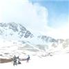
James Pk. (13294', Gilpin Co. HP) via St. Marys Glacier, 7/2/12, 7 mi. RT, 2920' of gain 2nd report of 6 on this tour This tour was about redemption for me. I have left a list of failed summits around the state and James was the most urgent miss to fix. Three years ago, I snuck in the backdoor, from Winter Park, and used the Ute Trail through Rogers Pass. I was about 1/2 mile from James' summit when I was thundered off...with graupel...then lightning. So returning here, on the east side, felt good. We had to transition from Boulder to Buena Vista today as well. We checked out of the Boulder hotel in the 4 am hour, ate breakfast, and drove the 80 miles to Alice. Without much more than a good topo from a previous TR, and the script from Roach's IPW book in my head, we started out at 6:55 am. We found the improved St. Mary's trailhead about 7 miles up Fall River Road from Interstate 70. We paid the $5 fee, backtracked a couple hundred feet and were hiking up the rutted road toward St. Mary's Lake. This was my first time viewing the Lake and Glacier, along with Fox Mountain...what a pretty spot. When it came time to hike along the right edge of the glacier, I realized this was not going to be as easy as I thought in trail runners. I was miffed as to why I had packed microspikes and not even considered bringing them today...they were in the car...duh. So we carefully made our way up the right side and I took a neat photo from the glacier back toward Fox Mountain and St. Mary's Lake. We met two hikers with two dogs having a blast coming down the glacier, then we entered the "Jamaica" meadow. We were on the obvious double-track until we met up with the Jeep road at a T-intersection. The guidance suggested turning left, then returning to a trail up James. I hesitated, something looked fishy to me as I looked at the map, then examined the landscape. I had mistaken Mt. Bancroft for James Peak and had been expecting to ascend the wrong summit. I showed Dave my rationale, pointing at features, then referring to the map. The good news is that we had not expended any additional energy aiming for Bancroft up to this point, although we would have figured out our mistake when we looked down cliff bands to the lakes. With that silliness out of the way, we took the cairned trail and it started to move up the REAL James Peak. We took a longer break close to the cliff edge where one can enjoy a nice view of five lakes. A party of three women closed on us, close enough to exchange pleasantries, then we moved on up the mountain while they started their own longer break as well. As we pressed up over 12500', then 13000', I led and Dave kept right on my heels. I felt like there was no way to shake him, he is such a strong hiker. I was surprised and complimented when Dave, huffing and puffing, told me that I was an excellent hill climber. It is fair to say that we enjoyed each other's company and pushed each other to be the best we could be, reminded each another to hydrate, eat something powerful, so forth. The summit of James finally yielded and I had my redemptive moment, at 11 am. At the same time I arrived, a male hiker came in from the northwest access/Ute Trail. I told him my story about being thundered off three years earlier. The 3 ladies caught up and the broad summit felt well-visited. I am so glad I opted to take the SE route, as it is a dry year in Colorado and St. Mary's Glacier is a very interesting...fun...way to gain James Peak. Dave really enjoyed it as well. We headed back down, making sure to take snapshots of the five lakes in the chasm. The clouds got thicker and by the time we were moving across Jamaica, we were doing so efficiently to avoid a thunderstorm. We reached the head of the glacier and carefully skipped down the northeast (left) side. It started to rain lightly, but never became troublesome. We met a lot of folks playing in the snow at the base of the glacier and chatted with a Canadian woman just below the glacier. There were a lot of folks in the camping area and hiking up from the access point toward the lake. We arrived back at the car at 1:19 pm. The fun acclimation hikes were over, now we moved on to longer Sawatch 14er routes. Thumbnails for uploaded photos (click to open slideshow):  St. Marys Glacier")
 Awesome!")
 View from James summit")
 Dave atop James Pk")
 Altitude")
 lakes")
 Dave on James")
|
| Comments or Questions | ||||||
|---|---|---|---|---|---|---|
|
Caution: The information contained in this report may not be accurate and should not be the only resource used in preparation for your climb. Failure to have the necessary experience, physical conditioning, supplies or equipment can result in injury or death. 14ers.com and the author(s) of this report provide no warranties, either express or implied, that the information provided is accurate or reliable. By using the information provided, you agree to indemnify and hold harmless 14ers.com and the report author(s) with respect to any claims and demands against them, including any attorney fees and expenses. Please read the 14ers.com Safety and Disclaimer pages for more information.