Download Agreement, Release, and Acknowledgement of Risk:
You (the person requesting this file download) fully understand mountain climbing ("Activity") involves risks and dangers of serious bodily injury, including permanent disability, paralysis, and death ("Risks") and you fully accept and assume all such risks and all responsibility for losses, costs, and damages you incur as a result of your participation in this Activity.
You acknowledge that information in the file you have chosen to download may not be accurate and may contain errors. You agree to assume all risks when using this information and agree to release and discharge 14ers.com, 14ers Inc. and the author(s) of such information (collectively, the "Released Parties").
You hereby discharge the Released Parties from all damages, actions, claims and liabilities of any nature, specifically including, but not limited to, damages, actions, claims and liabilities arising from or related to the negligence of the Released Parties. You further agree to indemnify, hold harmless and defend 14ers.com, 14ers Inc. and each of the other Released Parties from and against any loss, damage, liability and expense, including costs and attorney fees, incurred by 14ers.com, 14ers Inc. or any of the other Released Parties as a result of you using information provided on the 14ers.com or 14ers Inc. websites.
You have read this agreement, fully understand its terms and intend it to be a complete and unconditional release of all liability to the greatest extent allowed by law and agree that if any portion of this agreement is held to be invalid the balance, notwithstanding, shall continue in full force and effect.
By clicking "OK" you agree to these terms. If you DO NOT agree, click "Cancel"...
Well I believe this is my last trip to South Colony Lakes, and let it be known that I will not miss slogging up and down the old 4wd road. This is my first trip report although it was my 29th unique fourteener. We had already climbed Humboldt and Crestone Peak so the only one left for this TH was Needle. A couple of weeks ago I called my sister, and climbing partner, to see if she was ready to start this year's fourteener epic continuation. She was excited as always but said I would have to drive since she was missing one of the windows in her jeep. I told her 'Ok' and figured I would just bring the Pilot, it so turns out that my wife needed the pilot so I would have to make do with the Accord. Going back to my original statement, walking on roads is not one of my favorite things to do.
We stayed at the Westcliff Inn and got up at 3:30 with a departure time of 3:45 to head towards the TH. It is amazing to me what you can do when it is dark. Accord at the top of the 4wd road
I do not know the person standing in the background as this picture was taken after we descended and they were just in the parking lot. Obligatory sign in
We were on the trail by 4:30 and making our way up to the old 4wd trailhead, this is boring and dark so no photo for you here. Sun coming up on the needle
As we entered into the South Colony Lakes basin the sun was coming up and we could see our friend for the day. Last year we attempted the Peak to Needle traverse but ended up too high and had lost our instructions on the way so we had to turn back. Today it was just going to be Needle and I was really looking forward to it. Umm, this way.. this way
We were pretty sure we were headed the right direction
I had read a trip report from 8 days before from SnowLynx that had mentioned snow on BHP and a couple of snow fields while approachin BHP. I had never used an ice axe before nor did I own one, so I ran out and picked one up figuring it will probably come in handy for this trip and possibly in the future. I was glad I did. I was unaware how incredibly easy the ice axe makes it to travel up steep snow fields. Here is approaching the pass and ice axing up. Headed towards the pass Sometimes things are just kind of obvious Snowfield towards the constriction Trying out my new ice axe and Loving It
After making our way through BHP it was off to the East Gully as everyone has said before the rock is fabulous for climbing knobby and stable. But I cannot stress enough how important it is to keep track of where you enter the gullies and exit. I now understand how people get lost and get in trouble on this mountain. Jean ascending the East Gully
So we start to ascend the East Gully and find the going to be a little easier on the climber's right hand side. Before long we are heading up some fairly tough class 3/4 rock. This is when I realize because we are over to the right we missed the beginning of the dihedral and were about 200 - 250 feet above where you needed to make the crossover to the West Gully. Luckily I turned around to talk to my sister and was looking up at the ridge when I spotted a small cairn in the notch between the two gullies. So we had to descend and then crossover to the West Gully. Interestingly enough on our way down we ran into two climbers that were about to do exactly the same thing we had done. I believe he said his forum name was Wack215 and his climbing partner from New Mexico. I hope they had as good a day as we did. Marc in the East Gully trying to descend the 200 ft mistake
After the descent and crossover someone was nice enough to tie a yellow bungy cord to a large rock where you would have to exit the West Gully on the way down. This was very helpful so thank you. Entrance to the West Gully and the bungy cord Starting up the West Gully
We proceeded up the West Gully and marked the top of the gully with one of our treking poles. After that we made our way along the ridge and up onto the summit. Once again I cannot stress how important it is that you take in landmarks and pay close attention to where you are as you clear each ridge, we almost ended up going down the wrong gully because there are cairns all over the top of that mountain, I was lucky enough to have my sister with me who had taken note of a peculiar white rock that was next to a black cairn so she knew we were in the wrong place.
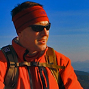
A couple of summit shots. We made it Summit shot and wildfire smoke haze
And then for the exciting/bummer part. We decided since we were not able to make the traverse last year we would wander over to the rappel point just to get a look at where we would have had to come up. Just after this picture was taken my sister got her shoelace caught on a rock and she fell just off the rock onto a lower flat spot on the summit. Just moments before the hand breaking incident
The problem was her foot had been taken out from under her so she fell on her hands and smacked her face pretty good on another rock. Turns out she broke her left hand. With the beautiful day and the injury we ended up spending about 45 minutes on the summit. Needless to say it was a little slower going on the way down but she made it. Looking down the West Gully into the valley behind BHP. Conditions look great
The descent was pretty uneventful except for the fact that there are some cairns that make it appear you should exit the East Gully too early on the descent. We did this and ended up at the top of another gully that looked like it might lead to the bottom of BHP in a manner that I was not comfortable with. So we backtracked and descended further then we came upon some other cairns and found the correct trail to the pass. On the way we came across two other climbers that were attempting the Needle that day. We gave them a few hints of things to look out for and headed back down. After the slog back down the 4wd road we were back at the car at 2:10 and on our way home.
Thumbnails for uploaded photos (click to open slideshow):
You said you had done Humboldt and Crestone Peak before. Were they seperate Hiles or is there someway to combine either those 2 and or any of them with the needle.
First of all, thank you for the great trip report, and the really nice photos. Second, how in the #$@% did you get a Honda Accord up that trail?! I felt like we were pretty lucky to get our 4WD Jeep up that thing. I bow to your off-road driving skills!
Amazingly enough the traction control is shot in that car, so it sends the power to the wheel that slips. Like I said it is amazing what you can do in the dark that you wouldn't try by the light of day.
That's awesome. I wouldn't write that area off; it's a beautiful area with amazing peaks (and amazing routes).
Congrats on completing the group, however.
Caution: The information contained in this report may not be accurate and should not be the only resource used in preparation for your climb. Failure to have the necessary experience, physical conditioning, supplies or equipment can result in injury or death. 14ers.com and the author(s) of this report provide no warranties, either express or implied, that the information provided is accurate or reliable. By using the information provided, you agree to indemnify and hold harmless 14ers.com and the report author(s) with respect to any claims and demands against them, including any attorney fees and expenses. Please read the 14ers.com Safety and Disclaimer pages for more information.
Please respect private property: 14ers.com supports the rights of private landowners to determine how and by whom their land will be used. In Colorado, it is your responsibility to determine if land is private and to obtain the appropriate permission before entering the property.


 Accord at the top of the 4wd road")
 Obligatory sign in")
 Sun coming up on the needle")
 Umm, this way.. this way")
 Headed towards the pass")
 Sometimes things are just kind of obvious")
 Snowfield towards the constriction")
 Trying out my new ice axe and Loving It")
 Jean ascending the East Gully")
 Marc in the East Gully trying to descend the 200 ft mistake")
 Entrance to the West Gully and the bungy cord")
 Starting up the West Gully")
 We made it")
 Just moments before the hand breaking incident")
 Summit shot and wildfire smoke haze")
 Looking down the West Gully into the valley behind BHP. Conditions look great")