Download Agreement, Release, and Acknowledgement of Risk:
You (the person requesting this file download) fully understand mountain climbing ("Activity") involves risks and dangers of serious bodily injury, including permanent disability, paralysis, and death ("Risks") and you fully accept and assume all such risks and all responsibility for losses, costs, and damages you incur as a result of your participation in this Activity.
You acknowledge that information in the file you have chosen to download may not be accurate and may contain errors. You agree to assume all risks when using this information and agree to release and discharge 14ers.com, 14ers Inc. and the author(s) of such information (collectively, the "Released Parties").
You hereby discharge the Released Parties from all damages, actions, claims and liabilities of any nature, specifically including, but not limited to, damages, actions, claims and liabilities arising from or related to the negligence of the Released Parties. You further agree to indemnify, hold harmless and defend 14ers.com, 14ers Inc. and each of the other Released Parties from and against any loss, damage, liability and expense, including costs and attorney fees, incurred by 14ers.com, 14ers Inc. or any of the other Released Parties as a result of you using information provided on the 14ers.com or 14ers Inc. websites.
You have read this agreement, fully understand its terms and intend it to be a complete and unconditional release of all liability to the greatest extent allowed by law and agree that if any portion of this agreement is held to be invalid the balance, notwithstanding, shall continue in full force and effect.
By clicking "OK" you agree to these terms. If you DO NOT agree, click "Cancel"...
Not much new here, just documenting another climb of Mt Sherman--so close, so comfortable, so beautiful, really.
We decided at the last moment to do Sherman instead of an Incline hike and left early (for us) from COS at 0430. Four in our party, including Anya, a "lowlander", but not a Flatlander from Lancaster CA. Her "only" other 14er was Whitney. We arrived at the trailhead at 0630 and were ready to hike at 0638, amazed by the total lack of wind and the clear skies with just a hint of forest fire smoke. The road (Four Mile Creek Rd) was in very good condition with no issues making it to the gate--in fact the gate was open and two SUVs had parked well up the traditional hiking trail .
I was first surprised to see the amount of recent damage done (presumably by wind) to the lower mining buildings at the trailhead and later to the bunkhouses at the first plateau. When you compare the photos below to a few of my earlier Sherman reports, you'll see the difference.
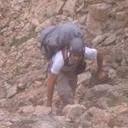
Two large groups were ahead of us and we passed them relatively quickly. Dave and I went ahead, thinking that we would add either Sheridan or Gemini to our agenda, then meet Dave at Anya along the way or at the car. The wind cooperated well and the ponds along the lower stretches of the trail made for some beautiful reflection shots.
The trail was in excellent condition most of the way, but some more social trails and shortcuts seem to have been cut leading to the first bunkhouse plateau area. The bunkhouses there had sustained major wind damage as cited above.
From here, we could see the snowy cornice on the Sherman-Sheridan saddle and there were a couple of folks descending by now, attempting to glissade down--it didn't look like a good idea without an ice axe and we made mental notes of the better routes around that area.
We only had one small snowfield crossing on the ascent and the trail was easily navigable behind the cornice and up the southwest spine of Sherman.
We met two more solo hikers descending while on the spine and made our way along the trail that skirts the north side of the ridge. Winds picked up slightly but were still well-below the Mt Sherman average that's blown me off the top more than once.
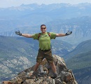
I made it to the summit in 1:24, taking photos along the way. I added a panoramic at the top while chatting with Dave and a newfound hiking buddy, Steve, in from Scotts Bluff NE.
Since Dave and Anya weren't in sight, we decided that we would do Gemini and then meet them back on the summit or during the descent. Steve joined us and we headed north along the ridge onto the tundra meadow.
We made it atop Gemini in a short 20 minutes and enjoyed our summit sodas there, taking in the views of the DeCaLiBro group, Collegiates, and Leadville below.
As we headed back, we could see throngs arriving at the Sherman summit, so I took my time and captured a few flower shots along the way.
We stayed at the Sherman summit for only a few minutes and headed southwest along the ridgeline, this time taking the south-facing branch of the trail in descent, catching up to Anya and Mike well before the saddle. They'd made the summit in right at two hours and had seen us on Gemini--I wore my optic yellow bike jacket for easy ID.
Anya joined Steve and me for a quicker descent, while Dave and Mike took a more leisurely pace. The descent was uneventful except for the standard surprise and dark comedy of crossing paths with so many woefully prepared groups just starting up the trail in the 1000-1030 timeframe as clouds were forming. We completed the hike and were in the cars four hours after we started, headed back to COS with plenty of pictures--all the while watching from our rearview as the clouds and precip envelope Mt Sherman and the clueless. All of the photos from this trip are available at my photo website.
My GPS Tracks on Google Maps (made from a .GPX file upload):
Nice report and enjoyed the climb with you guys. FYI, failed at the three today. apparently wasn't in good enough shape. Made it up to 12,455' at nearing the turn to head up Missouri. Just couldn't muster the steam for it. Next time.
I wish that I would have read this before I made a special trip to do some night photography on Sherman and the mining bunk houses. I got up there to shoot the bunk house that was the most intact to the East and much to my surprise it was a pile of rubble. Crazy that they would be up there 100+ years right? And just recently get flattened.
of a normally dull mountain. Some of those photos are incredible!!
Caution: The information contained in this report may not be accurate and should not be the only resource used in preparation for your climb. Failure to have the necessary experience, physical conditioning, supplies or equipment can result in injury or death. 14ers.com and the author(s) of this report provide no warranties, either express or implied, that the information provided is accurate or reliable. By using the information provided, you agree to indemnify and hold harmless 14ers.com and the report author(s) with respect to any claims and demands against them, including any attorney fees and expenses. Please read the 14ers.com Safety and Disclaimer pages for more information.
Please respect private property: 14ers.com supports the rights of private landowners to determine how and by whom their land will be used. In Colorado, it is your responsibility to determine if land is private and to obtain the appropriate permission before entering the property.


")
")
")
")
")
")
")
")
")
")
")
")
")
")
")
")
")
")
")
")
")
")
")
")
")
")
")
")
")
")