Download Agreement, Release, and Acknowledgement of Risk:
You (the person requesting this file download) fully understand mountain climbing ("Activity") involves risks and dangers of serious bodily injury, including permanent disability, paralysis, and death ("Risks") and you fully accept and assume all such risks and all responsibility for losses, costs, and damages you incur as a result of your participation in this Activity.
You acknowledge that information in the file you have chosen to download may not be accurate and may contain errors. You agree to assume all risks when using this information and agree to release and discharge 14ers.com, 14ers Inc. and the author(s) of such information (collectively, the "Released Parties").
You hereby discharge the Released Parties from all damages, actions, claims and liabilities of any nature, specifically including, but not limited to, damages, actions, claims and liabilities arising from or related to the negligence of the Released Parties. You further agree to indemnify, hold harmless and defend 14ers.com, 14ers Inc. and each of the other Released Parties from and against any loss, damage, liability and expense, including costs and attorney fees, incurred by 14ers.com, 14ers Inc. or any of the other Released Parties as a result of you using information provided on the 14ers.com or 14ers Inc. websites.
You have read this agreement, fully understand its terms and intend it to be a complete and unconditional release of all liability to the greatest extent allowed by law and agree that if any portion of this agreement is held to be invalid the balance, notwithstanding, shall continue in full force and effect.
By clicking "OK" you agree to these terms. If you DO NOT agree, click "Cancel"...
I just got back from a very satisfying and enjoyable climb of yet another wonderful Sierra peak. This one was Mt. Russell, one of twelve primary 14ers in the state of California (15 not counting the 300 foot of prominence rule). Russell, at 14,088 ft. is the 7th highest peak in California. I'm not gonna lie- the thought of climbing Russell, although I knew I was going to at some point, has scared me a bit. Being one of the most exposed 14ers in the state, it has a few world-class technical rock climbing routes on its broken and cracked south side (the Fishhook Arete and Mithral Dihedral), and seen from the north it resembles a steeply curved and smooth Conquistador helmet.
Russell's standard route is its east ridge, a classic if there ever was one which, only rated at class 3, is nonetheless amazing and tricky. Climbing it is what tightrope walkers must feel like at a circus. Russell's east ridge has very lethal consequences should you slip and fall in either direction. A fall to the north sends you skidding and then overboard completely 2,000 feet down to a nameless lake nestled against the sheer north face wall, and a fall to the south sends you in a free-fall for more than a thousand feet, only to come crashing down in the shattered boulders below. Indeed, Russell is a marvelous but scary beast, especially when climbing it solo unroped, and it now becomes my favorite 14er in either California or Colorado. It is that spectacular!
Early morning (Friday June 1st) I was up and on the trail at 3:30am from Whitney Portal at 8,350 ft. (gateway for climbing Mt. Whitney), hiking in the dark up the North Fork of Pine Creek, which was the launching point for assaulting Mt. Russell. I had some trouble locating the Ebersbacher Ledges in the dark, and these ledges are the only route past the sheer granite walls enclosing lower North Fork Pine Creek. Thankfully daylight slowly crept up across the land and soon enough I had zag zagged up the maze-like ledges and found myself at Lower Boy Scout Lake as dawn torched Whitney and its lower spires. I located the steep chossy chute that led to the mellower slopes of the Russell/Carillon plateau, and began whacking my way up it as the heat of the day began to build. This chute was awful, downright sucky in nature. It was a slumgullion stew of small rocks and soft sand, and for every two steps up, you would slide a step back. I tried to hug the lookers-right side of the chute as much as possible, as there were more solid rock ledges to climb and it was in the shade. Already at 9am it was sunny and getting warm.
Two hours of this slog-fest passed before I reached the top of it, which I am nicknaming "Devil's Artery" for its all around misery. But attaining the plateau was worth it. Out of the chute, you are instantly greeted by a pleasant and smile-inducing sight...a gentle sand and rock-speckled slope leading to the Russell/Carillon saddle. From there, Russell's fantastically sharp east ridge rose up to the west like a curving silver wave. Some people and publications (Super Topo for one) have suggested that this ridge is the best class 3 route you will ever do. Looking at it here, now, it didn't even seem like there was a class 3 route across it and I was curious as to where the actual route went.
I boulder-hopped up the start of the ridge and after 10 minutes the spicy climbing began. Instantly the ridge became a knife-edge, with serious and deadly exposure dropping off on both sides. I navigated this scary part to the northern side of the ridge, where magically a rock escalator materialized out of nowhere. This ramp was about two feet wide and traversed just below the ridge crest to the north. And so the route went, ever upwards, with massive and breath-taking exposure greeting you at every step. The north face just peeled off in a roll down to a nameless lake below, and it was a little nerve-wracking making sure every step and hand hold was solid before making the next set of moves. Fortunately, the granite here is bomber offering a buffet of good cracks and knobs to grab. Further along the ridge narrowed to a knife again, escalating the pucker factor once again. The route from this point forward (around 13,700 feet) was not always obvious and required some exposed yet solid moves, but when in doubt, I selected to climb the slabs on the north side of the ridge away from the ridge proper. A more solid climber than I would not have a problem here, but the exposed nature of this route in its entirety really plays on your psyche, and although you are now within reach of the summit, at this point you have been going hard for over six hours and pounded out just shy of 6,000 vertical feet in one single push.
After making some more leg-shaking moves, I finally attained the summit of Russell. Mt. Whitney instantly fills your eye as you gaze south, less than a mile away. So close it was I could see and hear some climbers at the top. Even though Russell reaches to 14,088 feet, it is obvious that Whitney is the undisputed monarch in these parts, as it looked much higher than where I was now. The views west into Sequioa National Park were spectacular of course, but I did not linger on the summit long, as the descent back along the harrowing east ridge loomed heavy on my mind. I just kept telling myself to take it slow and sure, and that is what I did. I finally got back to the saddle and instant relief washed over me, as I had reached much safer ground.
The descent down "Satan's Artery" was much improved from the climb up it. It's sandy complexion, so hard to ascend, made it so easy to descend. Ski-like movements were allowed as the foot met and sunk in the sand, sparing the knees of much jolting movements. The chute took two hours to climb and less than 30 minutes to get down. Then it was just a nice easy pace down out of the North Fork below Upper Boy Scout Lake, past LBSL and down the maze of the Ebersbacker Ledges. I reached the car at 3:30pm, with the whole nine mile, 6,000 vertical foot ascent and back taking about 12 hours roundtrip. At my age, I was unsure if I could pull off this climb car to car in a day, but I was able to do it and still drive back home to Tahoe afterwards.
In comparing Russell to what many consider Colorado's hardest 14er- Capitol, I would say that Russell is a degree or two harder than Capitol due to the length of its exposed ridge. While true that Capitol's summit ridge and its infamous "Knife" is very exposed and lethal to a fall, it is much shorter in length than Russell. Russell's class 3 designation would most certainly be class 4 in Colorado, and I wonder why the two states have such a discrepancy when determining the difficulty of the same type of terrain. Oh well. I have done both peaks and am glad to have accomplished them. Both Capitol and Russell are marvelous mountains.
looking to two eastern Sierra 14ers- Whitney and Russell, as seen from Lone Pine
looking up to Whitney Portal and Mt. Whitney
dawn fire lights up Mt. Whitney and its spires, as seen from Lower Boy Scout Lake
the jagged Whitney Crest reflected in Lower Boy Scout Lake in early morning light
Mt. Muir- 14,018 ft. juts out of the boney Sierra Crest
me on the Russell/Carillon Plateau, with Mt. Whitney behind
Mt. Russell stabs the sky
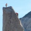
starting up Russell's east ridge
Koya high on Russell's east ridge- this is as far as she made it. Lake Tulanyio behind
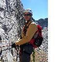
me on Russell's east ridge
looking to the slightly higher west summit of Russell, from its east summit
on the summit of Russell, with Mt. Whitney's north face behind
view north from Russell to Mt. Williamson- 14,375 ft.- 2nd highest peak in California
looking east across Russell's serrated east ridge to the hamlet of Lone Pine and the Owens Valley, 10,000 feet down
frozen lakes in the high basin just east of Mt. Russell
view off east ridge knife looking south to Upper Boy Scout Lake
view down the east ridge knife looking north to a nameless frozen lake, taken from the same spot as the preceding picture
Mt. Russell and its scary yet exciting east ridge, as seen from Mt. Carillon
looking 2,000 feet down "Satan's Artery"
Thumbnails for uploaded photos (click to open slideshow):
Hiked up past upper boy scout to the basin below Russel...what a peak! That route you describe to gain the ridge sounds as bad as it looks! Great job and thanks for the read
I don't think I've ever seen pics of Whitney and Russell taken from some of those angles before...I definitely miss the area, and your TR has increased both my excitement and trepidation at the idea of doing Russell someday! Congrats, and well done...
Wow, nice job on this route, it certainly is a beast. I attempted the east ridge as well back in '08 with my brother, but we backed off at the part where the ridge first knifes up-- just a bit too intimidating at that time. Your report perfectly captures the intensity of that ridge, and the fierce image of the peak from the east. Well done! This gets me amped for a return trip there to close the deal someday....
Caution: The information contained in this report may not be accurate and should not be the only resource used in preparation for your climb. Failure to have the necessary experience, physical conditioning, supplies or equipment can result in injury or death. 14ers.com and the author(s) of this report provide no warranties, either express or implied, that the information provided is accurate or reliable. By using the information provided, you agree to indemnify and hold harmless 14ers.com and the report author(s) with respect to any claims and demands against them, including any attorney fees and expenses. Please read the 14ers.com Safety and Disclaimer pages for more information.
Please respect private property: 14ers.com supports the rights of private landowners to determine how and by whom their land will be used. In Colorado, it is your responsibility to determine if land is private and to obtain the appropriate permission before entering the property.


 looking to two eastern Sierra 14ers- Whitney and Russell, as seen from Lone Pine")
 looking up to Whitney Portal and Mt. Whitney")
 dawn fire lights up Mt. Whitney and its spires, as seen from Lower Boy Scout Lake")
 the jagged Whitney Crest reflected in Lower Boy Scout Lake in early morning light")
 Mt. Muir- 14,018 ft. juts out of the boney Sierra Crest")
 me on the Russell/Carillon Plateau, with Mt. Whitney behind")
 Mt. Russell stabs the sky")
 starting up Russell's east ridge")
 Koya high on Russell's east ridge- this is as far as she made it. Lake Tulanyio behind")
 me on Russell's east ridge")
 looking to the slightly higher west summit of Russell, from its east summit")
 on the summit of Russell, with Mt. Whitney's north face behind")
 view north from Russell to Mt. Williamson- 14,375 ft.- 2nd highest peak in California")
 looking east across Russell's serrated east ridge to the hamlet of Lone Pine and the Owens Valley, 10,000 feet down")
 frozen lakes in the high basin just east of Mt. Russell")
 view off east ridge knife looking south to Upper Boy Scout Lake")
 view down the east ridge knife looking north to a nameless frozen lake, taken from the same spot as the preceding picture")
 Mt. Russell and its scary yet exciting east ridge, as seen from Mt. Carillon")
 looking 2,000 feet down \"Satan's Artery\"")