Download Agreement, Release, and Acknowledgement of Risk:
You (the person requesting this file download) fully understand mountain climbing ("Activity") involves risks and dangers of serious bodily injury, including permanent disability, paralysis, and death ("Risks") and you fully accept and assume all such risks and all responsibility for losses, costs, and damages you incur as a result of your participation in this Activity.
You acknowledge that information in the file you have chosen to download may not be accurate and may contain errors. You agree to assume all risks when using this information and agree to release and discharge 14ers.com, 14ers Inc. and the author(s) of such information (collectively, the "Released Parties").
You hereby discharge the Released Parties from all damages, actions, claims and liabilities of any nature, specifically including, but not limited to, damages, actions, claims and liabilities arising from or related to the negligence of the Released Parties. You further agree to indemnify, hold harmless and defend 14ers.com, 14ers Inc. and each of the other Released Parties from and against any loss, damage, liability and expense, including costs and attorney fees, incurred by 14ers.com, 14ers Inc. or any of the other Released Parties as a result of you using information provided on the 14ers.com or 14ers Inc. websites.
You have read this agreement, fully understand its terms and intend it to be a complete and unconditional release of all liability to the greatest extent allowed by law and agree that if any portion of this agreement is held to be invalid the balance, notwithstanding, shall continue in full force and effect.
By clicking "OK" you agree to these terms. If you DO NOT agree, click "Cancel"...
UN13285 and UN13111 In Attendance: Derek and Clay
Trailhead: About 2 miles shy of West Willow Creek TH
11.5 Miles
4,350' Elevation
This should be considered less as a "trip report" and more of a "route report" for anyone interested in hiking these. Hence the more nuts and bolts approach to it. I apologize if you were looking for a nice story to go with it.
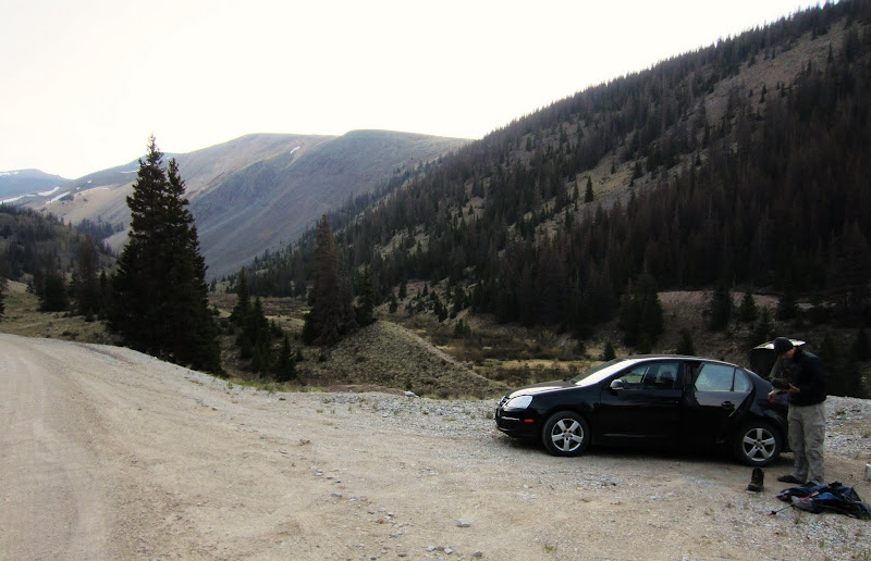
Clay and I left Denver around 7 PM Friday night, drove to Creede and began following the standard road (503) to the West Willow Creek Trailhead. Turns out this road is closed for a while due to a movie being filmed. (There is security positioned at the start of the road.) We backtracked and used CR504 which worked just fine. We reached a suitable pull off site about .5 miles shy of the Equity Mine around 11K. We could reach Equity Mine just fine in my VW Jetta, but anything beyond would require higher clearance. We finally rolled out the bivies and got to sleep around 12:30 AM.
UN13285
We started out at 7 AM the next morning. Instead of following the road up towards Equity Mine, we dropped east and crossed the creek that we had camped above and reached a paralleling old mining road on the other side. We followed this road about .25 miles north until we saw our best option for ascending the steep slope to our right. The slope took a little huffing and puffing, but we made it up without issue. Once on top of the slope, we were on the long slopes that led north towards the summit of UN13285. The top of this long slope also contains an old road that leads north towards the summit. This road is visible on most topo maps. We followed the road north over the gentle, rolling terrain until we reached the large rounded summit of UN13285. Or so it would seem. Turns out, the maps are incorrect on the location and elevation of this peak, and it is actually 13,300' and the true summit is about .15 miles east of where the map indicates is the high point. Knowing this ahead of time, we passed by the "fake" summit and topped out on the craggy top of the true summit. Views of San Luis and company from this summit are nice, although the haze from the fires made distant views sub par.
Parking/camp area about .5 miles shy of the Equity Mine. The slope we will be ascending is near where the trees end in the distance.
Ascending the 900' slope to the ridge top.
Equity Mine as seen from the slope.
Looking down the "leg-burner". -Photo by Clay
Ridge top and a smoky background, looking south towards Creede.
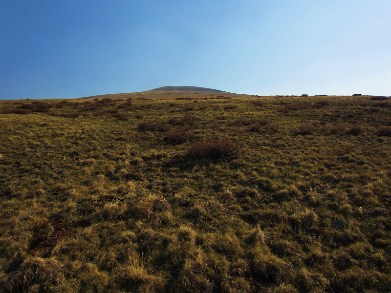
Looong gentle slopes to the summit of UN13285.
My footprints in the soft ground with UN13285 in the background. The ground here is almost like walking in sand.
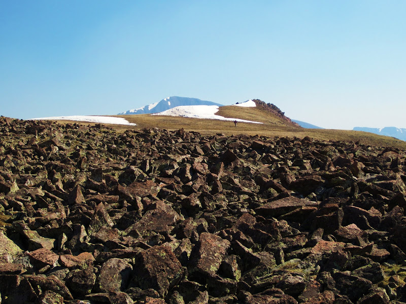
Clay near the true summit area of UN13285. The summit area indicated by the map is off to the left.
Clay scrambling near the summit. We traversed a short class three section to make sure we were on the true summit, but it was evident that the west point is higher.
San Luis Peak from the summit of UN13285.
UN13111
After a quick stay, we continued north along the ridge as slowly angled NW towards San Luis Pass. (San Luis Pass can also be reached directly by continuing on up the road that we drove in on, eventually turning to trail.) The descent of UN13285 was slow as there was a good amount of tricky talus on its north slope. The wind was also starting to really blow, which would be the norm for the day. We did not fully summit the 13,100 sub peak to the north of UN13285, mainly because we were trying to keep from blowing off the ridge. We bypassed the bump to the west, finally descending on a nice grassy slope towards Pt. 12540. Pt. 12540 is the rocky point that marks the first saddle on the south slopes route of San Luis. We passed around the point to the right, eventually reaching the Continental Divide trail. We then headed west until we reached San Luis Pass. From the pass, we continued along the Divide trail as it began to ascend towards the next peak of the day, UN13111. The peak was visible all the way from the pass. From the pass, there is around 1.25 miles and 1200' to reach the summit. The initial willows that block a direct ascent towards the summit are passed easily by the CD trail, and after the willows cease it is just a long, grassy slope up the east side of UN13111. The wind was pretty nasty, and any exposed skin felt like it was getting lots of little paper cuts from the blowing dry grass. It wasn't pleasant. Clay reached the summit first and found a nice hole to hide into until I got there. I joined him in the hole and we spent some time out of the wind. To descend, we headed cross country in a SE direction, aiming for the direction of the 4WD West Willow Creek TH which would allow us to follow the road back to the car. The grassy slopes provided easy walking (minus the wind) and any willow areas were easily passed through without issue. If going for UN1311 only, this would make a nice ascent route. It would be a very simple hike if you parked all the way at the 4WD trailhead. Once we finally reached the West Willow Creek 4WD trailhead, we follow the road another 2 miles south ending back at the car. We took off to Creede to enjoy a meal before meeting some others for a nice trip up San Luis the next day. (Greenhouseguy documented the next day nicely in his awesome trip report seen here: )
These mellow 13ers would make a nice addition to a weekend for someone in the area to climb San Luis Peak.
Traversing under the west side of Pt. 13100 along the ridge to San Luis Pass. UN13285 in the background.
UN13111 in the distant center from the ridge near UN13285. Looks like a long ways to go from here!
Clay riding the ridge.
Derek near Pt. 12540. -Photo by Clay
Looking back at UN13285 from near Pt. 12540.
On the continental divide trail with UN13111 in the distance.
Escaping the wind best we can on the summit of UN13111. Sorry, no real summit shots!
Clay tossing a couple stones in the air while on 13111, letting the wind shoot them away.
Scenic meadows we passed through on our descent from UN13111.
Pt. 13100 (l) and UN13285 (r) from earlier that morning in the distance during our descent.
Following the road back to the car. The ascent slope from the morning is seen on the left.
Route from the day- in red.
My GPS Tracks on Google Maps (made from a .GPX file upload):
Very nice. I love those long days above treeline on gentle slopes, almost looks like fall pictures. The La Garita's are one of my favorite places to visit.
Nice to see the details after having been there. Great TR.
Caution: The information contained in this report may not be accurate and should not be the only resource used in preparation for your climb. Failure to have the necessary experience, physical conditioning, supplies or equipment can result in injury or death. 14ers.com and the author(s) of this report provide no warranties, either express or implied, that the information provided is accurate or reliable. By using the information provided, you agree to indemnify and hold harmless 14ers.com and the report author(s) with respect to any claims and demands against them, including any attorney fees and expenses. Please read the 14ers.com Safety and Disclaimer pages for more information.
Please respect private property: 14ers.com supports the rights of private landowners to determine how and by whom their land will be used. In Colorado, it is your responsibility to determine if land is private and to obtain the appropriate permission before entering the property.


 >
>