Download Agreement, Release, and Acknowledgement of Risk:
You (the person requesting this file download) fully understand mountain climbing ("Activity") involves risks and dangers of serious bodily injury, including permanent disability, paralysis, and death ("Risks") and you fully accept and assume all such risks and all responsibility for losses, costs, and damages you incur as a result of your participation in this Activity.
You acknowledge that information in the file you have chosen to download may not be accurate and may contain errors. You agree to assume all risks when using this information and agree to release and discharge 14ers.com, 14ers Inc. and the author(s) of such information (collectively, the "Released Parties").
You hereby discharge the Released Parties from all damages, actions, claims and liabilities of any nature, specifically including, but not limited to, damages, actions, claims and liabilities arising from or related to the negligence of the Released Parties. You further agree to indemnify, hold harmless and defend 14ers.com, 14ers Inc. and each of the other Released Parties from and against any loss, damage, liability and expense, including costs and attorney fees, incurred by 14ers.com, 14ers Inc. or any of the other Released Parties as a result of you using information provided on the 14ers.com or 14ers Inc. websites.
You have read this agreement, fully understand its terms and intend it to be a complete and unconditional release of all liability to the greatest extent allowed by law and agree that if any portion of this agreement is held to be invalid the balance, notwithstanding, shall continue in full force and effect.
By clicking "OK" you agree to these terms. If you DO NOT agree, click "Cancel"...
Horseshoe Mountain (13 898 feet, 4 236 m, centennial 13er) Finnback Knob (13 409 feet, 4 087 m, unranked due to lack of prominence) Peerless Mountain (13 348 feet, 4 068 m, unranked due to lack of prominence) Mt. Sheridan (13 748 feet, 4 190 m, bicentennial 13er) Mt. Sherman (14 036 feet, 4 278 m, 14er) Gemini Peak (13 951 feet, 4 252 m, unranked due to lack of prominence) Dyer Mountain (13 855 feet, 4 223 m, centennial 13er) White Ridge (13 684 feet, 4 171 m, unranked due to lack of prominence)
I've been planning this trip for a while. One of the inspirations was a tripreport from Geojed, about his great achievement to hike almost the entire Mosquito Range in one day. Most importantly, I am not a fast hiker and also, I had nobody to go with so an option of parking one car at Fourmile Creek and another at Kite Lake was not there. So I had to plan something shorter and start and end at the same site. I am also peakbagging. One of my goals is to finish at least 100 mountains over 4000 m with prominence at least 100 m until mid August when I am leaving Colorado because I got a job in the Czech Republic. To achieve that goal, I am tempted to find groups of mountains to be hiked or climbed or mountaineered together in one day. Mosquito seemed to be an ideal range although I already hiked Sherman.
Morning view of White Ridge.
After rainy weekend, the forecast for Monday was the best possible. All day clear, sunny and no thunderstorms in the afternoon. Ideal for such a long trip. I started at an intersection of four roads at Fourmile Creek at about 11 600 feet. The plan was to hike all of the mountains and return from White Ridge. As on the first picture, the best way down seemed to be left of the summit where the slope seems gentle.
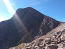
Horseshoe Mountain.
There are a lot of roads on the ridge to Horseshoe Mountain. I used one of them to get to the ridge, than I went through the tundra for a while and rejoined the same road a short distance before the saddle with Peerless. Ridge is mild, grassy, sometimes a bit of talus. Enjoyable hike. Once in the saddle, just continue to the summit of Horseshoe.
Sherman and company from Horseshoe.
Happy peakbagger counts another summit, #78 over 4000m.
Finnback Knob is an unranked bump on a shoulder of Horseshoe. I was not planning it first but then, on the summit of Horseshoe, I said, whatever, I am already here, lets go. Even though it will add about 700 vertical feet on my trip (its not possible/easy to bypass Horseshoe on the way to Peerless).
Horseshoe as seen from Finnback Knob.
Sheridan from Finnback Knob.
Peerless Mountain is not more of a mountain than Finnback Knob but at least it's on the way further..
Peerless summit photo.
And then the ridge leads you onto Sheridan. I love how this mountain looks from Sherman's slope, I remember it from years ago, when I hiked Sherman first. I wanted to hike it then and I was happy to achieve this goal.
Horseshoe from Sheridan.
Sherman from Sheridan
Sheridan from Sherman's slope.
Not mention that the views were awesome and the weather still looked exactly like in the forecast. No hurry, no rush, enjoy!!
The hike down from Sheridan is no big deal, hike up Sherman was supposed to be the 2nd largest elevation gain on this trip but it was no problem. The trail is good, snow was soft and only at some spots, in a comparisson to some of my recent 13er hikes, I'd call it an easy rosegarden walk-up.
Mt. Sherman.
On the summit of Sherman, the ridge stays snowy pretty long.
Gemini peak is just a walk from Sherman's summit.
Between Gemini Peaks.
And next target was Dyer Mountain. Another centennial 13er on my plan and at this time (3.30 pm) I started to be tired and thought about leaving it for another trip. But then, I said, lets go, try, and see in the saddle. It was not as deep as it seemed.
Next target - Dyer Mountain.
It was clear, that there are some snowfields to go over to the summit of Dyer Mountain. With microspikes and Ice Axe there should be no problem and it wasn't. Snow was soft and I'd have no problem to go for the summit without any of the gear.
Dyer Mountain.
Finally, at the summit of my 7th peak today and my 80th mountain over 4 000 m with at least 100 m prominence. Horray .
Dyer Mountain summited, happy peakbagger with his 80th peak over 4 000m.
Gemini Peak and Mt. Sherman from Dyer Mountain.
Back in the saddle, last view of Dyer Mountain.
And then I went back over Gemini Peak and continued back over a shoulder of Sherman. I though that the point on the right would be the White Ridge but it wasn't. White ridge was farther than I though.
Passed Gemini Peak, back towards Sherman.
So I passed that ridge and then I could see that White Ridge is about another mile far and lots of elevation to be lost and some elevation to be gained, over a false summit - of course. I was tired and not very pleased of it but I still had enough time, so, I decided to continue, although slowly.
Sunset oves Sheridan Peak.
It was easy hike again, the only thing that concerned me was how to get down to the road. I remembered, that the closer to the Sherman, the less steep the slope of White ridge looked. The summit is, of course, behind a false one.
White Ridge.
Sunset over Sheridan Peak.
Mosquito Range, Decalibron...
Sherman.
It was sunsetting and the view of the Mosquito Range was spectacular. I went back to the saddle between White Ridge and Sherman, to the lowest point and there is a gully starting. Its full of scree, deep and not slippery, very fine for walk down. I continued through a drainage, over some snow fields, towards the road. I made it and then I continued long walk to the car. I got there at 8.45 pm, 12.5 hours of hike.
I hiked Sherman in 2008. Just up and down. I liked it but this time I realized that being strictly tunned to 14ers made me miss a lot of beauty of the Rocky Mountains. If I should compare how I feel about the beauty of those mountains I hiked here, I'd say I love the look of Horseshoe, Sheridan, Gemini and Dyer more than Sherman itself. Horseshoe has the great bend, Sheridan looks like a roof, similar to Guyot and Grays, Gemini is a nice cone and Dyer was nice combination of snow and rock hike. During this trip, I had an opportunity to see the mountains from many different angles and perspectives. Much more than just a hike up the 14er and back to the car. And I enjoyed the great solitude. I did not meet anybody all the time. I hope I am not ruining this by writing a trip report on it.
And for the end, please, if you - great people on 14ers.com - like this report and have some suggestions of a group of fun and nice 13ers to hike before I leave, let me know.
Thumbnails for uploaded photos (click to open slideshow):
Congratulations on a great day of hiking for you--and reminding us that there's a whole lot more to our wonderful mountains than just going straight to the top of a 14er and back down to one's vehicle. All the best to you in the Czech Republic and getting to enjoy Europe's mountains.
Brian, the closet I found was this custom list, although I think their criteria is 300 feet of prominence rather than 100 m. I'd guess, there will be just several peaks softer ranked on this list of 547 peaks:
http://listsofjohn.com/PeakStats/Content/customlists.php?lid=487
Every time I see a photo of Boudoir Couloir this season I want to cry. Way to make a fun loop in the area! Horseshoe/Peerless/Finnback Knob/Sheridan was one of my favorites last year...you just took it a few steps further. Or, more accurately, about doubled it. Awesome.
Thanks SurfNTurf - it was on my list this year, I even wanted to PM you sometimes, I remember you replied on one of my posts about that earlier this year but its almost gone now .....
I appreciate the photos of the different views to identify peaks. I've never been in the Mosquito Range but am planning Sherman soon. Now I'll know what I'm looking at along the way!
My friend and I are planning to do this tomorrow. He came up from Houston Monday so I hope he is somewhat acclimated! We've been playing around Estes Park the last few days to get ready.
Caution: The information contained in this report may not be accurate and should not be the only resource used in preparation for your climb. Failure to have the necessary experience, physical conditioning, supplies or equipment can result in injury or death. 14ers.com and the author(s) of this report provide no warranties, either express or implied, that the information provided is accurate or reliable. By using the information provided, you agree to indemnify and hold harmless 14ers.com and the report author(s) with respect to any claims and demands against them, including any attorney fees and expenses. Please read the 14ers.com Safety and Disclaimer pages for more information.
Please respect private property: 14ers.com supports the rights of private landowners to determine how and by whom their land will be used. In Colorado, it is your responsibility to determine if land is private and to obtain the appropriate permission before entering the property.


 Morning view of White Ridge.")
 Horseshoe Mountain.")
 Sherman and company from Horseshoe.")
 Happy peakbagger counts another summit, #78 over 4000m.")
 Horseshoe as seen from Finnback Knob.")
 Sheridan from Finnback Knob.")
 Peerless summit photo.")
 Horseshoe from Sheridan.")
 Sherman from Sheridan")
 Sheridan from Sherman's slope.")
 Mt. Sherman.")
 On the summit of Sherman, the ridge stays snowy pretty long.")
 Between Gemini Peaks.")
 Next target - Dyer Mountain.")
 Dyer Mountain.")
 Dyer Mountain summited, happy peakbagger with his 80th peak over 4 000m.")
 Gemini Peak and Mt. Sherman from Dyer Mountain.")
 Back in the saddle, last view of Dyer Mountain.")
 Passed Gemini Peak, back towards Sherman.")
 Sunset oves Sheridan Peak.")
 White Ridge.")
 Sunset over Sheridan Peak.")
 Mosquito Range, Decalibron...")
 Sherman.")
 Horseshoe, Peerless, Sheridan in sunset.")