Download Agreement, Release, and Acknowledgement of Risk:
You (the person requesting this file download) fully understand mountain climbing ("Activity") involves risks and dangers of serious bodily injury, including permanent disability, paralysis, and death ("Risks") and you fully accept and assume all such risks and all responsibility for losses, costs, and damages you incur as a result of your participation in this Activity.
You acknowledge that information in the file you have chosen to download may not be accurate and may contain errors. You agree to assume all risks when using this information and agree to release and discharge 14ers.com, 14ers Inc. and the author(s) of such information (collectively, the "Released Parties").
You hereby discharge the Released Parties from all damages, actions, claims and liabilities of any nature, specifically including, but not limited to, damages, actions, claims and liabilities arising from or related to the negligence of the Released Parties. You further agree to indemnify, hold harmless and defend 14ers.com, 14ers Inc. and each of the other Released Parties from and against any loss, damage, liability and expense, including costs and attorney fees, incurred by 14ers.com, 14ers Inc. or any of the other Released Parties as a result of you using information provided on the 14ers.com or 14ers Inc. websites.
You have read this agreement, fully understand its terms and intend it to be a complete and unconditional release of all liability to the greatest extent allowed by law and agree that if any portion of this agreement is held to be invalid the balance, notwithstanding, shall continue in full force and effect.
By clicking "OK" you agree to these terms. If you DO NOT agree, click "Cancel"...
Here's my first attempt at a somewhat coherent TR. Bear with me!
After wrapping up my junior year in college for the semester, it was time to enjoy some outdoor adventures that were lacking thanks to the overwhelming homework load. Dang I hate personal responsibility..... Ok maybe not. I also needed some high altitude exercise so I can get in shape for the wildfire season that threatens to be very active. Ironically, the weather on this trip looked as if it was going mitigate wildfire hazards for the time being. Good news for the forest. Anyway, Mt. Columbia and I have a short history together. Every time I've planned on claiming the summit, the weather has other ideas in mind.
The Route
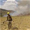
Beta for the Horn Fork Basin is basically the same as the last condition update. Road to TH is great. First 2.5 miles are basically dry with a little bit of live tree fall (about 5 trees total). There is a creek crossing where you turn of onto the Columbia snow route. After this junction the going gets significantly more difficult. We hiked the initial part of the trail that real kwick. From there on my partner and I experienced a big loss in momentum. We had a postholopolus or postholupoluzza in combination with like a bizzillion fallen trees on the trail that probably added and extra mile of meandering and wondering. Then we lost the trail in the snow and the fallen trees and wandered around for a bit never finding the turnoffs for the standard route.We also began following the Horn Fork through the muddy and icy marshes until we broke the clearing in the trees. We then reorientated and found ourselves missing the standard route turnoff. The presumable route we took, pink is the stretch of PHing and tree fall hazards Route viewed from Harvard in 2011 Route taken and not recommended
How about the weather? The Time Line
The story begins when we left GJ at 3am without a cloud in the sky, got to Leadville at 6...not a cloud in the sky. Started our hike at 7:15 not a cloud in the sky. Meandered through the forest until we broke treeline at 9:45 not a cloud in the sky and hot!
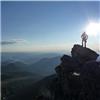
bluebird towards Harvard Mt. Yale
I was really breaking a sweat. 9:50 we have A cloud. 9:55 we got just a little bit of cloud. We got a cloud Zach pondering life's greatest questions
10:10 we got 75% overcast and dark cloud cover. I noticed Yale was getting a shellacking. In the interest in saving the trip, my partner and I decided to take a direct scramble to the summit ridge (not recommended scree mud mix).By 10:30 its snowing, 10:40 we got some thunder, 20 minutes later Zach climbing away things getting kwazy no visibility
11:30 we lost all visibility and gained the summit ridge. Originally I thought one of the bumps was the summit, but I couldn't find a summit register, a rock shelter, and the it didn't look familiar from my recollection of the summit panorama. Well I realized the route continued and because I could only see 10 yards in front of me, each "false summit" was very demoralizing.
By 12 we got to the summit with a glorious view of nothing. Socked in
We spent a total of 7 minutes on summit, complained about our cramping quads and ate some precooked bacon. We quickly moved across the ridge. I kept hearing weird electrical noises but there was sparse thunder. I figured that I am more likely to die from a wildfire than a lightning strike, so I wasn't "too" worried. There was still some concern. Our goal was to get to the snow route because we saw a lengthy patch of snow. One of our problems as we hiked the ridge is we couldn't see anything. I then spotted a small circular patch of snow and remembered seeing it in the morning. We argued for about 5 minutes whether or not this "drainage" was the snow route until we came to a consensus that it was the coliour. We had a mud scree mix for about 50% of the coliour. However, we were able to glissade for around 1000 ft. We quickly strapped on our gaiters, continued to complain about cramping quads, and descended the snow. Glissade via snow route Zach as a ghost Some dude I met. Ok maybe not
The route below treeline from the snow route was a bit of bush whack, but it was much more efficient than the ridiculous amount of tree fall on the standard trail. However, we were very pleased with the ease of the non traditional dry winter route we took. The clouds lifting briefly giving us some surreal views of Mt. Yale. Yale summit (Edited a little bit) Yale summit in fog
The fog set in pretty heavy on our way out and made walking around in the trees even more erie. fog setting in
It was also very dark and I was often confused about the time. At 2:30 it felt like 8pm with the relative lighting. Once we got by to the TH it poured. My partner and I decided to go back to GJ and not attempt Yale the next day since our summit views were absolutely pathetic. I'm currently regretting this decision after seeing the recent Mt. Elbert TR. I'm very jealous.
Hopefully this helps somebody. Happy climbing everyone.
RC Trail into Harvard. Snow thins out on main trail and becomes more hard packed past treeline
Thumbnails for uploaded photos (click to open slideshow):
We're going to attempt this duo this weekend, thanks very much for posting. I can't believe how dry the area is; the weather this week won't exactly help either. Glad you guys got down safely, sounds like it was a bit spicy up there!
RJansen77: If you are considering Columbia I would look into taking the snow route. It might actually save you some time rather than dealing with tree fall and post holing which there is a lot of. The trade offs include a lot of scree until you reach snow which is very stable and a minimal bushwhacking. I think it would save a ton of time. Unless you are looking at Harvard too. Good luck!
BostonBD: thanks for the positive comments. Happy climbing!
”........ glorious view of nothing”. 5/16/2012 9:04pm
I've seen that same view from several mountains. Who are those youngsters in the photo? We ”old white men” don't like having it rubbed in our faces by you kids half our age!!!
I did Columbia by its long SE ridge last winter. We had clear skies the entire slog up with postholing from the TH to the summit (took like 8 hours!) We also got to the summit and got fogged in...although once we descended a few hundred feet the sun was out again! WTF. Anyway, very well written TR!
Its not the first, but the most coherent and the best thus far. I love reading other TR's so I got to pay it forward. Even if it is Columbia.
PHing is definitely very frustrating, I had a terrible time with it at La Plata in March. PHoling to my waist in high flotation snowshoes. It sucked!
Caution: The information contained in this report may not be accurate and should not be the only resource used in preparation for your climb. Failure to have the necessary experience, physical conditioning, supplies or equipment can result in injury or death. 14ers.com and the author(s) of this report provide no warranties, either express or implied, that the information provided is accurate or reliable. By using the information provided, you agree to indemnify and hold harmless 14ers.com and the report author(s) with respect to any claims and demands against them, including any attorney fees and expenses. Please read the 14ers.com Safety and Disclaimer pages for more information.
Please respect private property: 14ers.com supports the rights of private landowners to determine how and by whom their land will be used. In Colorado, it is your responsibility to determine if land is private and to obtain the appropriate permission before entering the property.


")


 The presumable route we took, pink is the stretch of PHing and tree fall hazards")
 Route viewed from Harvard in 2011")
 Route taken and not recommended")
 Mt. Yale")
 20 minutes later")
 Zach climbing away")
 things getting kwazy")
 no visibility")
 Socked in")
 Glissade via snow route")
 Zach as a ghost")
 Some dude I met. Ok maybe not")
 fog setting in")
 Yale summit (Edited a little bit)")
 Yale summit in fog")
 bluebird towards Harvard")
 Zach pondering life's greatest questions")
 We got a cloud")
 Trail into Harvard. Snow thins out on main trail and becomes more hard packed past treeline")