Download Agreement, Release, and Acknowledgement of Risk:
You (the person requesting this file download) fully understand mountain climbing ("Activity") involves risks and dangers of serious bodily injury, including permanent disability, paralysis, and death ("Risks") and you fully accept and assume all such risks and all responsibility for losses, costs, and damages you incur as a result of your participation in this Activity.
You acknowledge that information in the file you have chosen to download may not be accurate and may contain errors. You agree to assume all risks when using this information and agree to release and discharge 14ers.com, 14ers Inc. and the author(s) of such information (collectively, the "Released Parties").
You hereby discharge the Released Parties from all damages, actions, claims and liabilities of any nature, specifically including, but not limited to, damages, actions, claims and liabilities arising from or related to the negligence of the Released Parties. You further agree to indemnify, hold harmless and defend 14ers.com, 14ers Inc. and each of the other Released Parties from and against any loss, damage, liability and expense, including costs and attorney fees, incurred by 14ers.com, 14ers Inc. or any of the other Released Parties as a result of you using information provided on the 14ers.com or 14ers Inc. websites.
You have read this agreement, fully understand its terms and intend it to be a complete and unconditional release of all liability to the greatest extent allowed by law and agree that if any portion of this agreement is held to be invalid the balance, notwithstanding, shall continue in full force and effect.
By clicking "OK" you agree to these terms. If you DO NOT agree, click "Cancel"...
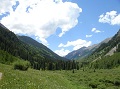
Dodging the winds, the ice fields and the willows of the Missouri Gulch
Dodging the winds, the ice fields and the willows of the Missouri Gulch
Routes: Up - Mt. Belford - Northwest Ridge (switchbacks); standard route to Mt. Oxford and back; Descent - Missouri Gulch via Elkhead pass Date: January 14, 2012 RT Distance: About 12 miles Elevation Gain: approximately 5,700 feet Time: 11 hours including the time on the summits and the time lost in the Missouri Gulch (more on that later) Who: Lynn (LynnKH) and Natalie (nkan02)
I am starting to suspect that climbing 14ers in winter is getting more and more popular. As we pulled into the parking lot of the Missouri Gulch TH shortly after 6 am, we found 5 or 6 parked vehicles - not that much difference from the summer scene. After gearing up (leaving snowshoes in the car, but taking more water than we normally would) we started out at 6.25am.
Alpenglow
The approach
It was my 2nd time in the Missouri Gulch and Lynn's 3rd, so we know what to expect - an unrelenting sequence of the switchbacks on the approach trail all the way up until the "old shack" (a.k.a. camping spot) at 11'200, and this time, we were mentally prepared. We were making good time on the boot-packed trail and reached the bottom of Mt. Belford shortly after 8.00am. As the number of the cars at the TH indicated, the trail was "crowded" (for winter, at least). We could see at least 6 people ahead of us ascending Belford, 2 behind us (Matt & Chris) and a few people going in the direction of Missouri.
First look at Belford
The climb
Going up Belford, our pace slowed considerably as the winds picked up and we stopped a few times to adjust the gear (and to admire the views of Missouri).
View of Missouri from Belford
Despite wearing 2 face masks (albeit not continuously throughout the day), both of us still ended up with a fair amount of windburn by the end of the day. The NW ridge trail was easily identifiable with very little snow, but we used microspikes for better traction. We reached the summit of Belford by 11am and stopped for 1/2 hour refueling break to prepare for the traverse to Oxford and back.
near the summit
We had the energy for another summit that day, but I knew it was not going to be a quick jaunt there and back. The mental game was on! On the descent from Belford we ran into amazing Roland and Laura who were already making their way back (they had passed us earlier in the day at the bottom of Belford). What an amazing speed and endurance! We carefully proceeded further, trying to save some energy for the return trip.
Heading over to Oxford
View of Harvard from the saddle
It felt very cold and windy above 13,800, but near the saddle, it was still windy, but the temperatures felt like 10-20 degrees warmer. We finally got to the Oxford summit at about 1pm.
Oxford summit
The views of Belford across the saddle were amazing. Matt & Chris soon caught up with us and we spent a few minutes on the summit together. Soon it was time to head back, and to reclimb Belford. This was probably the toughest section of the day, and the anticipation of which did not let me enjoy the Oxford summit as much as I otherwise would.
View of Belford from Oxford
Image #10 (not yet uploaded)
Belford ridge
The return
As we were going up Belford, we were discussing the return routes. We both did not want to take the Northwest ridge's switchbacks back. The couloir to the left of the NW ridge looked like an interesting option, but I was concerned about the snow quality. The couloir remained in the shade for the most part of the morning, and I worried that the snow would be very hard and crusty, making self arrest somewhat treacherous. Besides, I wanted to "save" the snow route for spring.
Belford couloir
Lynn mentioned that last time she came down the Elkhead pass route and it was fast. This option appealed to me as I wanted to check out the Missouri's East ridge and the interesting looking Emerald and Iowa which we spotted from Belford.
Emerald peak as seen from Belford
So down to the Elkhead pass we went.
Elkhead pass panorama (Emerald, Iowa, Missouri)
We knew that the route was going to add extra mileage, but we were hoping it would be reasonably fast going. The first part went according to plan. We quickly dropped elevation and were at the top of Elkhead pass in about 15 minutes since leaving Belford's summit ridge. The views of the nearby peaks were amazing. Then we promptly lost the trail leading down to the Missouri Gulch, as it was covered with snow. Our trail-less progress towards the Missouri Gulch was stopped by an expansive ice field/hill.
Icefield
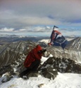
We decided to drop into the gulch bypassing the ice slope to the left of it vs. going around it. Lynn went with rocks and I went with snow. The snow conditions, as I had anticipated, were far from good - it was either sugary, posthole-prone snow or a bulletproof hard pack, rendering microspikes and ice ax nearly useless. It took me twice the time to descend the steep snow field vs. Lynn's option with talus.
Bulletproof snowfield near the top
Another look at snowfield
Couloir overview. A small dot on the right side is me.
Nasty looking icefield
The curse of the Missouri Gulch
The good news were were back on the Missouri Gulch trail and making decent time. However, this did not last long as the trail disappeared once again. Trying to identify the precise direction of the trail and to avoid snowfields proved to be challenging. The posthole fest began. We tried to follow existing tracks, but at some point, a promising looking track split 3-ways. We chose one set of tracks but soon they disappeared. Here we were, approximately last 100 feet away from merging into the Belford trail (we could see Matt & Chris who just descended from Belford), but separated from it by deep, deep snow. That section, done without snowshoes, zapped the little energy what was left in us. The message was clear: don't mess with the Missouri Gulch, even in the low snow year.
Willows of the Missouri Gulch
Once on the firm ground, we tried to make up for lost time, but it was getting late. We finally got back to the car at dusk, thoroughly exhausted but glad to have both summits in the bag.
Sunset
And now, this is all we have to show for an extra hour of detour. Was getting this view worth going an extra mile and an extra hour? I guess, the answer is - it depends
View of Emerald from Elkhead pass
Missouri's East Ridge
Thumbnails for uploaded photos (click to open slideshow):
Granted this is only my second winter season, but I agree with you on the crowds. I've noticed tons more people out this winter compared with last. Maybe once (if) the snow comes it'll thin out a bit. Nice work on a long, exhausting route! Let's get out again soon.
Caution: The information contained in this report may not be accurate and should not be the only resource used in preparation for your climb. Failure to have the necessary experience, physical conditioning, supplies or equipment can result in injury or death. 14ers.com and the author(s) of this report provide no warranties, either express or implied, that the information provided is accurate or reliable. By using the information provided, you agree to indemnify and hold harmless 14ers.com and the report author(s) with respect to any claims and demands against them, including any attorney fees and expenses. Please read the 14ers.com Safety and Disclaimer pages for more information.
Please respect private property: 14ers.com supports the rights of private landowners to determine how and by whom their land will be used. In Colorado, it is your responsibility to determine if land is private and to obtain the appropriate permission before entering the property.


")


")


 Alpenglow")
 First look at Belford")
 View of Missouri from Belford")
 Belford couloir")
 near the summit")
 Heading over to Oxford")
 View of Harvard from the saddle")
 Oxford summit")
 View of Belford from Oxford")
 Belford ridge")
 Elkhead pass panorama (Emerald, Iowa, Missouri)")
 Emerald peak as seen from Belford")
 Icefield")
 Bulletproof snowfield near the top")
 Another look at snowfield")
 Couloir overview. A small dot on the right side is me.")
 Nasty looking icefield")
 Willows of the Missouri Gulch")
 Sunset")
 View of Emerald from Elkhead pass")
 Missouri's East Ridge")