Download Agreement, Release, and Acknowledgement of Risk:
You (the person requesting this file download) fully understand mountain climbing ("Activity") involves risks and dangers of serious bodily injury, including permanent disability, paralysis, and death ("Risks") and you fully accept and assume all such risks and all responsibility for losses, costs, and damages you incur as a result of your participation in this Activity.
You acknowledge that information in the file you have chosen to download may not be accurate and may contain errors. You agree to assume all risks when using this information and agree to release and discharge 14ers.com, 14ers Inc. and the author(s) of such information (collectively, the "Released Parties").
You hereby discharge the Released Parties from all damages, actions, claims and liabilities of any nature, specifically including, but not limited to, damages, actions, claims and liabilities arising from or related to the negligence of the Released Parties. You further agree to indemnify, hold harmless and defend 14ers.com, 14ers Inc. and each of the other Released Parties from and against any loss, damage, liability and expense, including costs and attorney fees, incurred by 14ers.com, 14ers Inc. or any of the other Released Parties as a result of you using information provided on the 14ers.com or 14ers Inc. websites.
You have read this agreement, fully understand its terms and intend it to be a complete and unconditional release of all liability to the greatest extent allowed by law and agree that if any portion of this agreement is held to be invalid the balance, notwithstanding, shall continue in full force and effect.
By clicking "OK" you agree to these terms. If you DO NOT agree, click "Cancel"...
MOUNTAIN: Humboldt Peak (14,064') ROUTE: East Ridge RT GAIN: ~5,500 feet RT DISTANCE: ~13.5 miles RT TIME: 9.5 hours (from Rainbow TH, 8 miles and 4,300 feet) CLIMBERS: SurfNTurf (Jeff), dillonsarnelli (Dillon), MonGoose (Nick), Claybird (Clay), speth (Matthew), Brian Thomas (duh), nkan02 (Natalie), LynnKH (Lynn)
There are some winter days where you look at your partner and ask, "Is this really winter? Does this even count?"
The temperature is approaching the 30s, you're down to your baselayers, the sun roasts you like a tanning bed. (Ahem, not that I'd know what that feels like.) The wind is nothing more than a caressing breeze that wipes away the sweat from your forehead.
That's the kind of day Dec. 26 was supposed to be. With a forecast of 5-10mph winds, sun and a high of 25, it couldn't be better.
But Old Man Winter decided not to be so welcoming, after all.
With calendar winter beginning Dec. 22, a day off on Dec. 26 and no plane ticket to visit my folks back East, I decided to gauge interest on a Christmas weekend hike. The response was overwhelming. After a bit of discussion, we decided on Humboldt Peak's East Ridge. I wanted to throw in a winter camp to revisit fond memories of Horn Fork Basin last winter, and as plans firmed up a group of six of us planned on camping Dec. 25 and attempting the summit Dec. 26. A sizable group of dayhikers was supposed to meet us on the route, but in actuality only Lynn and Natalie ended up representing the one-day crew.
We arrived at the winter closure on Colfax Lane and started hiking up the road at about 4:45 p.m. Christmas night. We'd only made it a few steps from the cars before we saw a lone climber coming down. Spoke537 had summited, solo, and informed us we had a trench all the way to treeline. I had to restrain myself from hugging him. We knew we'd benefit from awilbur77's fine effort up to 11,600 on Dec. 24, but we had no idea the trail would be so long and well-established.
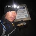
The group gearing up (photo courtesy Claybird)
Brian starting up the trail in fading light
Do you think Santa Claus will find us out here? (photo courtesy Claybird)
We figured we'd be dealing with darkness anyway, so we took our time getting up to camp - something like two hours to cover 2.5 miles and 1,300 feet. Nick was experimenting with a sled and I wasted plenty of time scribing goofy messages to the dayhikers in the snow. Anyway, we eventually set up our three tents via headlamp at the Rainbow TH and got a fire going. We melted snow, drank a couple beers, gobbled down calories and went to bed at 10:30 or 11.
Huddling around the campfire
We got a leisurely start the next morning, giving the dayhikers time to catch up. We left camp around 7:30 a.m. In retrospect, we should have started an hour or two earlier. The trail, established by awilbur77 and further packed by Spoke537, was a highway through the trees. I reluctantly left my brand new (Christmas present!!!) snowshoe tails in my tent. We'd heard wind during the night, but the forecast hadn't changed. We remained blissfully ignorant of what was to come.
First light at camp (photo courtesy Claybird)
Dillon, Clay and Matthew starting up the trail
Me and Dillon, reveling in the broken trail (photo courtesy Claybird)
The trail descends 50 to 100 feet to a creek, then starts steeply up. Eventually it gains a minor ridge and takes an abrupt left turn. The ridge flattens out for a good long while, and then the warm up is over. Once it starts getting steep again, don't expect a reprieve until you're on the summit - except for a short flat section high on the ridge.
Once the trees started thinning, we caught glimpses of Marble Mountain and the surrounding peaks. The Spanish Peaks had distinct snow plumes coming off their summits. We heard a bit of a growl up high. Uh-oh.
On top of the minor ridge, with the false summit and trench in view
Spanish Peaks, and our first hint of the wind to come
The track disappeared along with the rest of the trees, wiped away by the wind. We could see the distinct banshees and plumes dancing on all the surrounding summits now, including ours. The dream of a perfect bluebird day was dashed.
The trench fades away along with the trees (photo courtesy nkan02)
We climbed into the wind, breaking our own trail for a few hundred feet. The dayhikers Lynn and Natalie caught up to us about the time we stashed our snowshoes (buried under mounds of rocks to ensure they didn't become kites) at 12,600.
Wind gust (photo courtesy Claybird)
Our group, as first seen by the dayhikers (photo courtesy nkan02)
I told you it was windy (photo courtesy nkan02)
The wind gusted close to 50mph, routinely knocking us off balance. It diminished slightly on the false summit (which has its own false summit) so we regrouped as best we could there. Our destination was finally in sight: the summit of Humboldt Peak.
Humboldt comes into view on a flat area just past the false summit
Wind gust slams the group (photo courtesy dillonsarnelli)
Like a caged greyhound, Dillon scampered off toward the summit with seemingly limitless energy. The wind remained a nuisance, still gusting to 30-40mph. Considerable exposure lurked over the right side of the ridge. Most steps on the sugary, unconsolidated snow got one's attention. Despite the difficulties, we all summited between 1:30 and 2 p.m. It was virtually windless.
Me and Lynn starting the final push up the ridge (photo courtesy nkan02)
Getting closer...
Looking back on the East Ridge
Dillon summits! Followed by the rest of us...
The views of the Crestones, of course, were astounding. Kit Carson, Mt. Adams, Broken Hand Peak, the Blanca Group, the Spanish Peaks - the summit panorama didn't disappoint. Nick claimed the first Winter Tebow Ascent of Humboldt Peak, while I decided to start my own trend.
Dillon's first glimpse of the pristine summit (photo courtest dillonsarnelli)
And the best photo of the Crestones goes to... (photo courtesy nkan02)
Kit Carson Peak
Campers on the summit (L-R Nick, Clay, Brian, Jeff, Dillon) (photo courtesy dillonsarnelli)
Dayhikers on the summit (L-R Natalie, Lynn) (photo courtesy nkan02)
Cam Newtoning (he has a Superman TD celebration)
Realizing we'd be racing darkness, we started back at about 2:15 and high-tailed it down the ridge. The wind had abated a little, but it was still a pain.
Looking back on the way down, winds still whipping
Saying goodbye to the sun, from the snowshoe stash at 12,600
Me and Brian departing the ridge (photo courtesy dillonsarnelli)
Finding the start of our route back through the trees was a bit of an ordeal, as the wind had swiped away most of our tracks. We found it after about five minutes of searching and raced down to camp, which we reached at about 5 p.m. in the last remnants of daylight. We managed to break down our tents and get back on the trail in about an hour. Navigating by headlamp, we returned to the cars shortly before 7 p.m.
Breaking down camp. If it looks like we just went through a war, it's because we felt like it (photo courtesy dillonsarne
Head down, motor out... (photo courtesy Claybird)
It was a first winter ascent of Humboldt for everyone except Lynn (her second), and a new peak for me, Dillon and Nick.
Merry Christmas!
Thumbnails for uploaded photos (click to open slideshow):
No love for the gas station fiasco in the TR?... 12/28/2011 2:15am
probably for the better...
a caged greyhound - haha - I'm definitely not feeling like a greyhound today! Excellent report Jeff as always. Great weekend and couldn't of asked for a better way to spend the holidays in Colorado. Thanks again for putting it all together. Very good meeting all of you. This was a sweet group. Will see you all soon I hope.
I know, Anna, I can't believe I went back either! But the view of the Crestones was totally worth the repeat. Like Nat said, trying to find the trail at tree line all I could think was we didn't stand a chance in those white-out conditions. No wonder!
@Anna - actually, Lynn kept reciting to me your ”thrilling” hike last March on the way. We both sure were glad it took under 12 hours this time instead of 16 (and she finally got to see the snow-covered Crestones - it was totally worth the repeat visit). We only shaved maybe an hour off your time on the way up (and we had the snowshoe trench already in place), but had much better descent time. However, this was due to a much better weather also (no whiteout) and no snowshoe fiasco, so the following the trail on the way back was not an issue.
As SurfNTurf mentioned, even in nearly perfect weather, locating the snowshoe trail in the trees at 12K is not very obvious and took a little bit of time. Lynn said that in a white-out conditions like last March, you guys did not stand a chance.
Caution: The information contained in this report may not be accurate and should not be the only resource used in preparation for your climb. Failure to have the necessary experience, physical conditioning, supplies or equipment can result in injury or death. 14ers.com and the author(s) of this report provide no warranties, either express or implied, that the information provided is accurate or reliable. By using the information provided, you agree to indemnify and hold harmless 14ers.com and the report author(s) with respect to any claims and demands against them, including any attorney fees and expenses. Please read the 14ers.com Safety and Disclaimer pages for more information.
Please respect private property: 14ers.com supports the rights of private landowners to determine how and by whom their land will be used. In Colorado, it is your responsibility to determine if land is private and to obtain the appropriate permission before entering the property.


")

")

")

")


")
")
")
")

")
")


")
")

 (photo courtesy dillonsarnelli)")
 (photo courtesy nkan02)")
")


")

")
 Brian starting up the trail in fading light")
 Huddling around the campfire")
 First light at camp (photo courtesy Claybird)")
 Dillon, Clay and Matthew starting up the trail")
 On top of the minor ridge, with the false summit and trench in view")
 Spanish Peaks, and our first hint of the wind to come")
 The trench fades away along with the trees (photo courtesy nkan02)")
 Our group, as first seen by the dayhikers (photo courtesy nkan02)")
 I told you it was windy (photo courtesy nkan02)")
 Humboldt comes into view on a flat area just past the false summit")
 Me and Lynn starting the final push up the ridge (photo courtesy nkan02)")
 Getting closer...")
 Looking back on the East Ridge")
 Dillon summits! Followed by the rest of us...")
 Dillon's first glimpse of the pristine summit (photo courtest dillonsarnelli)")
 And the best photo of the Crestones goes to... (photo courtesy nkan02)")
 Kit Carson Peak")
 Campers on the summit (L-R Nick, Clay, Brian, Jeff, Dillon) (photo courtesy dillonsarnelli)")
 Dayhikers on the summit (L-R Natalie, Lynn) (photo courtesy nkan02)")
 Looking back on the way down, winds still whipping")
 Saying goodbye to the sun, from the snowshoe stash at 12,600")
 Breaking down camp. If it looks like we just went through a war, it's because we felt like it (photo courtesy dillonsarne")
 Cam Newtoning (he has a Superman TD celebration)")
 The group gearing up (photo courtesy Claybird)")
 Do you think Santa Claus will find us out here? (photo courtesy Claybird)")
 Me and Dillon, reveling in the broken trail (photo courtesy Claybird)")
 Wind gust (photo courtesy Claybird)")
 Head down, motor out... (photo courtesy Claybird)")
 Me and Brian departing the ridge (photo courtesy dillonsarnelli)")
 Wind gust slams the group (photo courtesy dillonsarnelli)")