Download Agreement, Release, and Acknowledgement of Risk:
You (the person requesting this file download) fully understand mountain climbing ("Activity") involves risks and dangers of serious bodily injury, including permanent disability, paralysis, and death ("Risks") and you fully accept and assume all such risks and all responsibility for losses, costs, and damages you incur as a result of your participation in this Activity.
You acknowledge that information in the file you have chosen to download may not be accurate and may contain errors. You agree to assume all risks when using this information and agree to release and discharge 14ers.com, 14ers Inc. and the author(s) of such information (collectively, the "Released Parties").
You hereby discharge the Released Parties from all damages, actions, claims and liabilities of any nature, specifically including, but not limited to, damages, actions, claims and liabilities arising from or related to the negligence of the Released Parties. You further agree to indemnify, hold harmless and defend 14ers.com, 14ers Inc. and each of the other Released Parties from and against any loss, damage, liability and expense, including costs and attorney fees, incurred by 14ers.com, 14ers Inc. or any of the other Released Parties as a result of you using information provided on the 14ers.com or 14ers Inc. websites.
You have read this agreement, fully understand its terms and intend it to be a complete and unconditional release of all liability to the greatest extent allowed by law and agree that if any portion of this agreement is held to be invalid the balance, notwithstanding, shall continue in full force and effect.
By clicking "OK" you agree to these terms. If you DO NOT agree, click "Cancel"...
Mount Harvard - standard route - a taste of winter
The 14ers Gathering in the San Juans aquainted me with lots of great new partners and a fresh snowfall beckoned for us to be out. 14ers.com users BenoftheEast (Ben), Nelsoq (Quinten) and I met in Buena Vista for the easy drive to the North Cottonwood Creek trailhead. Gearing up, we started up the lightly snow-covered trail at 8:30 AM.
Quinten ready at the trailhead
The pretty forest trail wound along the creek, crossing it a few times on bridges, and slowly gaining altitude over several miles.
When the trail turned north we knew it was leading into Horn Fork Basin.
Shortly after clearing treeline, a snow-dressed Mount Columbia came into view on our right.
Ben with Mount Columbia in background
The snow on the trail was still just a few inches deep and our packs were heavy so we began considering stashing our snowshoes. The trail steepened into switchbacks after another mile and the snowshoes were left to wait. When we topped the rise, Bear Lake could finally be seen behind us.
Bear Lake
The snow was deeper and we postholed occasionally but it was route-finding that was the growing difficulty. Large cairns appeared but infrequently and we had to refer to the route map/description and GPS waypoints.
Finally, we reached the steep and rocky slope below the summit ridge. The route description showed switchbacks between the rocks but any easy trail was hidden under unconsolidated powder that was sometimes waist deep. The rocks were coarse-grained granite that would have provided nice traction when wet or dry but the fresh powder snow greased it so every step required caution.
Dave demonstrates grovel technique for deep powder climbing
Ben took the lead and powered up the incline while finding a good path for us.
Ben leading up to the ridgeline
Shortly below the summit ridge, we could see the wind driving clouds and snow across the ridgeline so we stopped to throw on our windshells and goggles. We climbed along the ridge while staying a few dozen yards below the crest.
The weather cleared as we neared the top and the views were amazing.
The summit showed a final challenge with obvious class 3/4 climbing on what was supposed to be a class 2 climb.
Dave climbing near the summit
While Ben clambored up the snow and ice covered rocks, Quinten and I scouted further along the ridge and found a much easier path from the ridge that connected to Mount Columbia. With the team gathered at the summit, we celebrated for a few minutes but a time check showed it was already 5 PM. We started our descent after just five minutes at the top because we wanted to get down both of the steep slopes in daylight.
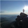
Ben's summit pic
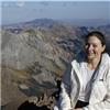
Quinten and Dave at summit
Shortly below the summit we met two climbers, 14ers.com users TheGreatCamillo and Dannyg23 coming up from the ridge to Mount Columbia. They had camped in Horn Fork Basin for an early start up Mount Columbia and were summiting their second 14er of the day in near-winter conditions. Kudos, dudes!
We made it back to the easy trail above treeline before dark but discovered that Quinten's headlamp was malfunctioning. Quinten had a small backup light and I offered to share the light of my headlamp but a bright moon reflecting off the clean snow made lighting almost unnecessary. Ben enjoyed most of the tramp through the forest trail by moonlight only!
Although we were hungry and more than ready for a good rest at the trailhead, our pace down the route was slowed by tiredness from the long day's efforts. When we arrived at the trailhead at 9 PM, a final event awaited. A Chaffee County Sheriff deputy was checking out my car and immediately asked for me by name. It turned out that my family could not remember exactly which peak I had told them we were climbing that day. They were accustomed to a call from me after summer climbs by early afternoon. When my call was hours late, my son reviewed my emails/14er.com posts to find out which peak we were on. Unfortunately, my son could only narrow it to Mount Harvard or Mount Antero. The Chaffee County Sheriffs checked for my car at several trailheads on each peak but were not very happy about the wasted time. The deputy made me promise to leave my family with a detailed written itinerary including team members and equipment on my next climb. My bad, I was wrong and I promised. Those guys do a lot of good work and I regret adding unnecessary work to their day.
It was a great adventure on a beautiful mountain with good friends!
Thumbnails for uploaded photos (click to open slideshow):
Hey, I'm one of the guys that came from Columbia - I really apreciated the trail you guys made coming down Harvard, you saved us a ton of route finding time on an already long day!
Nice write-up, Dave! Thanks for doing that. And thanks for the company. That picture of Bear Lake is at sunset on our way down. It sure was a sweet one!
I remember being surprised by the scrambling up there, too, when I climbed Harvard last March. I was expecting Class 2, but what I found was exposed Class 3/4. Not much fun in mountaineering boots and two layers of gloves. I've always wanted to go back in summer and see where the ”easy” route is...sounds like you might have found it.
Those pictures are beautiful. It looks as if you had a good time. Great Job!
Caution: The information contained in this report may not be accurate and should not be the only resource used in preparation for your climb. Failure to have the necessary experience, physical conditioning, supplies or equipment can result in injury or death. 14ers.com and the author(s) of this report provide no warranties, either express or implied, that the information provided is accurate or reliable. By using the information provided, you agree to indemnify and hold harmless 14ers.com and the report author(s) with respect to any claims and demands against them, including any attorney fees and expenses. Please read the 14ers.com Safety and Disclaimer pages for more information.
Please respect private property: 14ers.com supports the rights of private landowners to determine how and by whom their land will be used. In Colorado, it is your responsibility to determine if land is private and to obtain the appropriate permission before entering the property.


 Quinten ready at the trailhead")
")
 Ben with Mount Columbia in background")
 Bear Lake")
 Dave demonstrates grovel technique for deep powder climbing")
 Ben leading up to the ridgeline")
 Dave climbing near the summit")
")
")
")
 Ben's summit pic")
 Quinten and Dave at summit")