| Peak(s): |
The Index - 13,417 feet Little Finger - 13,212 feet Monitor Peak - 13,707 feet Turret Peak - 13,837 feet Animas Mountain - 13,789 feet |
| Date Posted: | 10/02/2011 |
| Modified: | 10/03/2011 |
| Date Climbed: | 08/08/2011 |
| Author: | sgladbach |
| Peak(s): |
The Index - 13,417 feet Little Finger - 13,212 feet Monitor Peak - 13,707 feet Turret Peak - 13,837 feet Animas Mountain - 13,789 feet |
| Date Posted: | 10/02/2011 |
| Modified: | 10/03/2011 |
| Date Climbed: | 08/08/2011 |
| Author: | sgladbach |
| The Index and Little Finger |
|---|
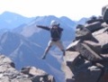
Youth- it's wasted on the young!Ruby Basin in the Weminuche Peter Blank- Rock Leader Steve Gladbach - Sack of Potatoes 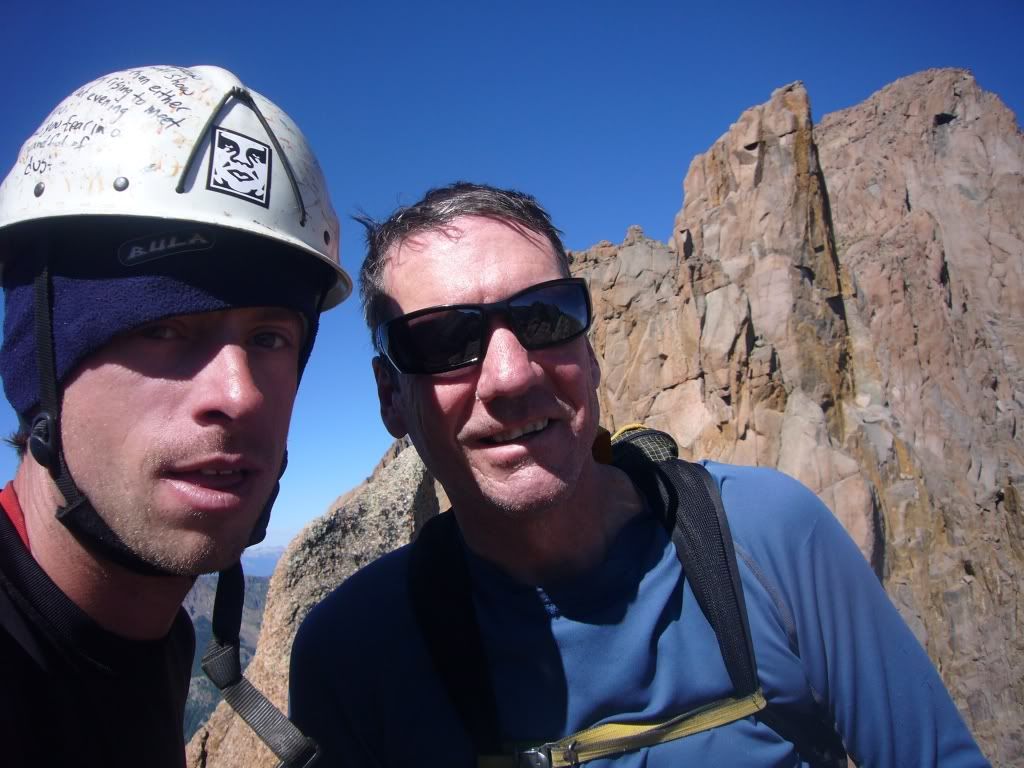 Purpose: The primary intent of this Trip Report is to provide much needed beta for The Index and Little Finger. There isn't much out there! If you need clarification, send me a PM. Major Goals: The Index 13,420' (Detailed on Day 11 ) Peak 17 (aka Little Finger) 13,220' (Detailed on Day 12 ) Secondary Goals: Pigeon 13, 972' (Day 10) Turret 13,835' (Day 2) Monitor 13,695' (Day 6) Peak 13 (The Scepter) 13,705' (Day 8 ) Animas Mountain 13,786' (Day 8 ) As I'm inclined to do, I have my eye on completing another "list" - climbing Colorado's USGS-Named, but "Unranked" peaks which are 13,000' or higher. There are 637 peaks on the list of Ranked summits over 13K' and another 106 (total 743) if you wish to include the USGS-Named, yet "Unranked" peaks. Actually, I've had my eye on this "Unranked" list for a good while. I consider it a worthy goal since only one climber, Peter Stabolepszky, is thought to have completed the list. The 637 Ranked and the original 106 named, Unranked peaks can be found in the index of Mike Garratt and Bob Martin's: Colorado's High Thirteeners: A Climbing and Hiking Guide. Having completed the 637 ranked 13ers, I've been working many years to climb those other 106 peaks. I've picked off those that Ken Nolan refers to as "The low-hanging fruit." However, there's been little progress for several years; about a dozen peaks remain for me to climb in order to complete the Unranked list. Some that I have yet to climb are easy, but three or four are pretty difficult and, thus, the real sticking points. Though my TRs over the years have left readers with the impression that I know what I'm doing, the truth is I am a skilled GENERAL mountaineer. My skills are weakest in the areas of technical rock and technical ice. Hence, in order to complete my list, I have needed to recruit rock-leaders. The problem with recruiting your average rock leader is that (s)he is primarily interested in exciting walls which provide good rock and acrobatic challenges. These can be found very close to town and only minor efforts are usually required to reach the base of the climbs. El Dorado Canyon, Shelf Road, Garden of the Gods, Ophir Wall, and similar world-class rock climbing can be reached by locals out for an afternoon of fun. Sport climbers generally are not interested in bushwhacking four hours to a remote campsite while carrying a 60lb backpack stuffed with technical gear and then starting at 4:30AM the following morning for a 3000' slog up a sharp, unstable couloir simply to reach the BASE of a short technical climb. The breed of climber I was looking for is probably best labeled an Alpinist, a Trad Climber, or a Mixed Climber. Generally, to catch their interest, there must be a level of intrigue surrounding the peak. This often combines interesting early ascents, few reported ascents, and little to no reliable data about what to expect. The Index and Peak 17 (Little Finger) definitely provide those qualities. For 6 years, I've been trying to recruit a rock leader for a trip to Ruby Basin (as the crow flies, about a mile little WNW of the very popular Chicago Basin in the Weminuche Wilderness.) In this inspiring cirque you are surrounded by heralded Centennial and Bi-Centennial ranked 13ers like Pigeon, Turret, Peak 15, Monitor, and Animas. Named, but Unranked 13ers in the basin include Peak 16, Peak 17 (Little Finger), Peak 13 (The Scepter), and The Index (located just west of Animas Mountain.) Collectively, the ridge from Turret to Little Finger is often called: "The Needles." A series of follies have plagued me for the past six years. I attempted Little Finger several times with partners who are my age-based peers. The first year, my partner and I reached the alcove on Little Finger, but found ourselves incapable of pushing the crux move. I didn't even attempt the more difficult Index. A year later, I planned the trip with a more accomplished trad-leader (an old buddy from Iowa). Unfortunately, a week before our trip was to begin he tore a rotator cuff while wrestling pigs on his farm. The third year, we scheduled the trip again, but I tore my shoulder Labrum. The two of us were quickly approaching our Golden Jubilee birthdays; that may explain how the fourth year arrived and the same partner tore his other rotator cuff! The fifth year, I recruited a leader who was a bit taken aback by the difficulty of humping all that gear to the campsite and then ascending the extreme scree field between Little Finger and North Eolus. Even so, once we reached the base of the climb he breached the crux on Little Finger and solved the second problem as well, but, unfortunately, impending darkness and difficulty figuring out how to finish the route drove us back to camp. We had packed it in about 50' shy of the summit. Now spent, physically and psychologically, the remainder of the technical portion of the trip was aborted in favor of some class 3 scrambles on 13ers. Obviously, it was time for some younger blood. I left the comfort zone of my regular partners and even the regular websites that I use to vet potential new partners. I started a thread on Summitpost and found a young man who typically hangs out on MountainProject. Peter Blank is 20 years younger than me and hungry for some Alpine ascents. His regular partners stick to the very difficult, but easy-to- reach walls of Telluride, Ophir and Ouray. Peter and I communicated via e-mail and phone. We didn't actually meet until the night before we boarded the train in Durango for what turned out to be a 12-day adventure with 9 nights at Ruby Lake and an extra trip to town to re-equip with hardware and re-stock some food. Day 1 On the morning of July 30th, Peter and I boarded the Narrow Gauge train in Durango bound for the Needleton Bridge. Disembarking at 12PM, we immediately diverged from the Chicago Basin-bound masses and headed in a northeasterly direction to Ruby Basin and a campsite at Ruby Lake. The lower portion of the trail is notoriously hard to follow and we, like many before us, lost the trail. Staying on the basic route, but inadvertently below the best trail, we lost some time making it to the lake. We were not using a GPS, but for those who do, the waypoints can be found in Dave Cooper's book: Colorado Scrambles: A Guide To 50 Select Climbs In Colorado's Mountains. Here are two big hints: 1.) There are two meadows to cross. The first is located about 3/8 mile into the hike and the second is 300 yards later. The first has a definitive trail across it, but the second meadow is overgrown in grass. Cross this second meadow on an easterly bearing. Cross at the widest spot; ignore any adjacent campsites. If you re-enter the woods at the correct spot, a trail will become evident within 100'. Do not pursue any faint game trails. Do not leave this area until you are confident that you have located the trail on the far east side of the meadow. There may be a decent cairn as the rail re-enters the forest; we built a nice one, but this meadow is a heavily used hunter's camp. 2.) At about the 1.5 mile mark, you will cross West Pigeon Creek. An old trail continues straight ahead and appears to follow a logical track. Do not go straight ahead. As soon as you cross the Creek, GO STRAIGHT UPHILL. The dirt and sand quickly congeal into a very steep, but recognizable trail. You should be confident in your choice within 60 yards or so. Here is a general map of the Route to Ruby Lake 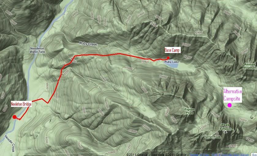 With a full pack, plan three to the 3 mile uphill trek to Ruby Lake. In the past, I've always used the "Alternative Campsite" located in a stunning meadow 900' above and one mile beyond Ruby Lake. Plan another hour. Last year, in a lightning storm above timberline, Peter had been rendered temporarily unconscious by a ground current; he awoke in a pile of vomit. Surprisingly, he had no interest in camping above timberline and, as the trip would eventually play out, we wound up spending nine nights at the lake. Two-thirds of the trip came with daily rain and lightning. Although we invested an extra 1 � hours each day on the round-trip to the meadow above, the Ruby Lake campsite turned out to be the best choice for our adventure. Pete also found other worthy lakeside pursuits 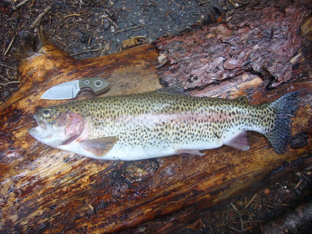 Day 2 Our first goal was to get an overview of potential routes on The Index, the peak about which we knew the least. To that end, we began our second morning with a 5:30AM departure for Turret and Pigeon. These peaks are located on the south side of the valley and provide the best views The Index to Monitor ridge on the valley's north side. Using the standard route to the summit, we stood on Turret by 9AM. However, as would prove the norm for the next 6 days, rain and thunder loomed early. Upon our 9:45AM return to the Turret-Pigeon saddle, we felt it imprudent to shoot for Pigeon. The skies were gray and the clouds were spitting gropple, so we headed down. As it turned out, electricity never developed. Turret Route 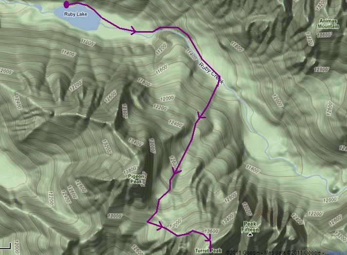 We THOUGHT our reconnaissance had revealed a route which we could use to breach the WSW branch of the Animas/ Index ridge which must be crossed to reach the summit block on the back (north) side of this auxiliary ridge. We eyed a steep, black couloir which we'd tackle the next day en route to the summit block of The Index. Little did we know! Day 3 and Day 4 A 5AM start on August 1st took us to the base of our chosen route to cross the WSW arm coming off the Index/Animas east/west ridge; we arrived at the base about sunrise. To reach this gully, we rounded the SW face of the Index and turned up the first major gully leading to the WSW ridge. The lower reaches went smoothly, but we had to rope and place pro to reach the top of the ridge. Once there, the same early precipitation and our lack of confidence in our chosen route (we couldn't determine our next move) sent us back to camp with no more information than the knowledge we needed a better approach to breach the ridge. We returned to the valley floor and lightning chased us back to the lake. We crawled in the tents about 1:30 and let the weather blow over. Later, on the evening of Day 3, from the lake we were able to eye-ball a second option for reaching the summit block of The Index. We'd tackle the most direct route, the SW face. Since we'd be directly under the summit block, this route avoids the necessity hike past the peak, turn around, and climb back in the direction from which we'd come in order to get to the SW face by climbing over the WSW ridge from the SE side (as we had tried earlier in the day.) Day 4: Reaching the summit block via the SW Face (as viewed from Ruby Lake) 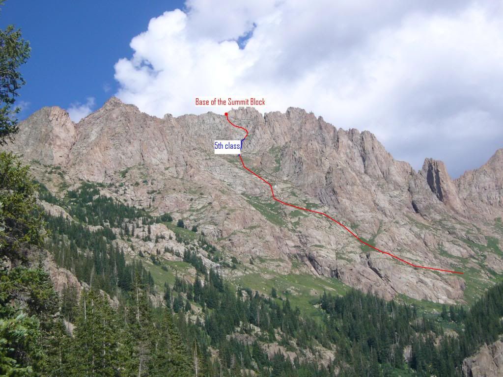 On the morning of Day 4, after managing a 4:30AM start; we were hopeful that the route we identified the evening before would deliver us to the summit block for an early attempt at the top. However, we only managed to learn a bit more about the best route to the summit block of The Index. The lower portion of the SW face went quite well, but in the upper reaches, we had to rope and set pro for a couple half-pitches. After maneuvering through this region we traveled unroped, passing under the spot where yesterday we had reached the ridgetop from the opposite side. As we completed our class 3 finish to the summit block, we identified an alternative route to this easy terrain that, like yesterday's choice, came from the opposite side of the ridge. We'd investigate more on the descent. We reached the summit block about 10:45AM. Only 200' below and 100 yards from the summit, we knew we could not attempt today. Ugly weather was looming. However, on our descent, we checked out the notch that we'd passed earlier which provided access to a couloir dropping to the meadows of the alternative campsite. A glance down looked as if this gully may be the answer to easily crossing the WSW ridge from the SE side, thus delivering the climber to the summit block without the need for class 5 climbing. At the couloir's upper entrance, we found a sling that had been used to rap a short 15' cliff at the top of the gully. After that, the gully easily descended toward the meadows located between Turret and Animas. Though in excellent condition right now, this gully surely holds snow and ice until late season. We were confident that on an ascent we could locate this gully even in pre-dawn light since the silhouette of the notch would be easily discernible from the SE side of the ridge. We etched strong mental notes into our brains for a third attempt. The route we discovered, and which we used for our next two attempts, is detailed below in green. Map of our three approaches to the summit block. To reach the best gully, Round the WSW face, pass the first set of gullies, and attack the ridge from the second gully-filled semi-basin. Photos to follow on Day 11. 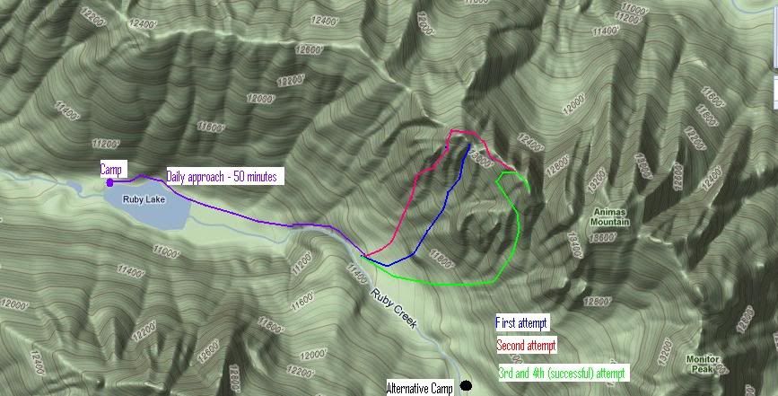 Day 5 Little Finger : Further detail on Day 12 Another discouraging day. Ready to take a break on The Index, we left camp at 5AM to tackle the nasty scree field that leads to the North Eolus / Peak 17 (Little Finger) saddle. There is more beta available on Little Finger than there is for The Index and I've twice stood in the alcove at the top of Little Finger's first pitch. Consequently, the approach to the base of the climb went quite smoothly. From a Ruby Basin camp, hike east to a difficult, loose, scree and sand-filled couloir. Ascending this couloir while laden with technical gear has taken me anywhere from one to two hours from the upper meadow. Little Finger and its Ascent Couloir 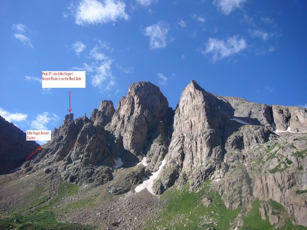 Once through the Peak 17 / North Eolus saddle, you drop 100' and then make a climbing traverse back to the ridge. You will find the route at the base of the wide, western couloir of the Little Finger pillar. A half pitch above the staging area is a giant alcove which provides the belay station for the crux. With Pete, we made as short a work as possible and reached the base of the technical work about 2 hours out of the lower, Ruby Lake camp. Pretty respectable, really. In this alcove, you are presented with the crux of the route. It consists of a very awkward, very off-width and difficult to protect chimney whose entrance is blocked by a 15' cliff. It is that cliff that defines the difficulty of the route. On one attempt, I'd stood here with Marlyn Peet. We were each unable to make the crux move. A year ago, Tom Pierce led me on this portion of the route without too great a difficulty, but he'd had to lead the route quite run-out. With lots of help, I'd reached the top of this second pitch, but a bit higher looming darkness and uncertainty about the remainder of the route turned us around. Today, Pete and I again reached the alcove, but, like Marlyn and I several years earlier, neither of us was able to tackle the crux. In addition to its normal difficulties, the gateway cliff was quite wet due to the daily rains we'd been experiencing. After a good 'ol college try, we left again in defeat. This time, we didn't have the weather (except for the wet route) to blame. Like The Index, we planned to return. Details Day 12. Day 6 We had five days and five nights behind us, and we'd merely managed to climb the easiest peak in the basin, Turret. Today we'd planned a third attempt at the Index, but it was raining steadily when we'd planned to leave at 4:30AM and we saw no reason to climb out of the tent until it finally subsided about 7:30AM. We crawled out of our tents prepared for a day in camp. As we sat around a morning fire, we both suddenly declared, "Let's do Something!" So, with an 8:30AM push-off we headed up-valley toward Monitor. We pulled off Monitor smoothly by its standard route, but when we returned to its saddle with Peak 13 (The Scepter), the weather forced us down. Normally, Monitor connects nicely with The Scepter and Animas, but, today, the thunder was clapping before our hurried descent brought us to the valley floor. Well, we had TWO peaks! Monitor's Standard Route 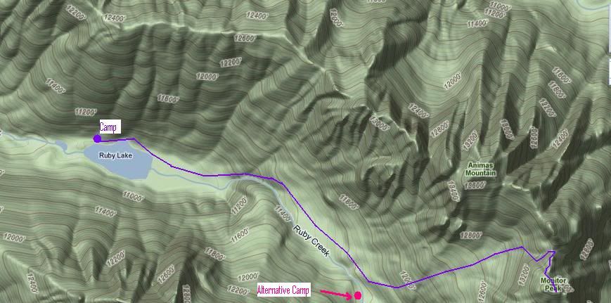 Day 7 Now confident with the approach to the summit block of The Index, we left camp at 4:30AM and stood at the base of the summit block at 8AM. The route is described in detail on Day 11. The short version is that the summit block consists of three towers. To begin, climb the first, but skirt the highest point. Next, downclimb 50' from the saddle of the first two towers and locate a 80' crack to the summit of the second tower. It was here, with the first accurate and unobstructed view of the final tower and its rumored awkward off-width, that Pete proclaimed, "We don't have the right pro!". Armed with the two #4 Big-Bros that rumor had it would be correct, Pete's sharp eye told him that the Big-Bros were too big and his rack was devoid of the #s 4.5, 5, and 5.5 cams that he felt he'd need. Still, we rapped from the summit of Tower II to its saddle with Tower three. Pete made a valiant effort to grab the true summit, but the final, unprotectable (with our gear) 15' left the summit unclaimed. SHITE!! A 100' rap from the second saddle took us back to our packs for the 3 hour walk of shame to camp. However, Pete showed no hesitation in declaring that we were headed back to Durango and his house in Ouray to get the correct gear! He was undaunted. Day 8 We had 2/3 of a day to kill before meeting the 3PM train from Silverton, so we decided to tackle the rest of the Ranked 13ers on the north side of the Valley. Usually combined with Monitor, weather had foiled our earlier plans for a three-peak day. Today, a 5AM start and a much simpler route than available on The Index or Little Finger allowed us to summit the peaks and return to camp before noon. We left the majority of camp set up and headed off to the train with very light packs. On the descent, we made careful mental notes so that, upon our return, we'd avoid the trail-finding issues we'd had on our trip in to Ruby Lake. The strategy worked well and we had no further problems with losing the trail to/from Ruby Lake. Our Scepter to Animas Route 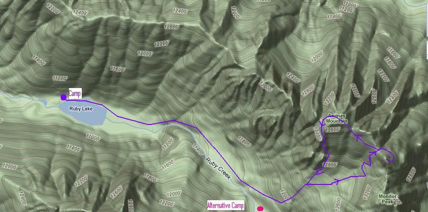 We arrived at the train stop in plenty of time to make the scheduled departure. However, during our 8 day foray, and its corresponding rains, a major mudslide had damaged the tracks and had closed the full route to Silverton. The DSNGRR company was backing a train in to Needleton, once a day, so that backcountry travelers could share a ride to civilization with the maintenance-of-way railroaders who were coming off-shift after working all day to clear the tracks. After waiting for the employees to join before heading to Durango, we arrived in town about 8PM. Day 9 Pete had the idea that rather than heading to Ouray for his large cam, and then hoping to locate another from one of his friends, and possibly purchase a third along the way, we'd be better off trying to get some in Durango. He planned to hit up the climbing stores in town in an attempt to "rent" some large cams. We both knew that no store would assume the liability to rent such gear, but the hope was that one of the techies at the climbing stores would know somebody who'd rent from his personal stash. Fortune shined upon us and, on the very first contact, a wonderful guy (who'll remain un-named) offered to loan us his personal stash. Having once been an aficionado of Vedauwoo's famous off-width routes, he was flush with the perfect cams. We had to beg him to accept payment and finally settled on two pounds of gourmet coffee. Due to his generosity, we were able to get the gear and food that we needed in a single day and re-board the train for Needleton on Day 10. Day 10 Once again bound for Needleton, we were re-supplied with more food and the proper pro. Days 8 and 9 had been dry and the week-long forecast was quite promising. Thus began three days of reality following plans! We followed the trail quickly and accurately. Eventually, we reached the high point of the trail's traverse along the west face of Pigeon; here, the trail begins a slow descent into Ruby Creek. At 1PM Peter loaded me with the heavy gear and he took off to summit Pigeon via a west ridge route. He returned to camp using a more standard Pigeon / Turret route which crosses the saddle between the two. His standard descent route is described in several guidebooks. He said the west ridge was harder than it looked. He came in to camp about 7PM. He had now climbed all the ranked 13ers traditionally reached from Ruby Basin. I had yet to get a single peak that I hadn't summited before. Peter's Pigeon Route 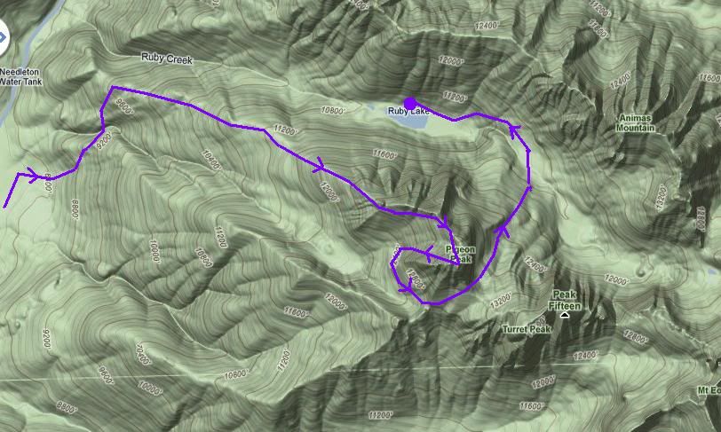 Day 11 Success on The Index: Full Route Description We wake intent on finally solving the problems on The Index. The first two days were used up learning the route to the base of the summit block and then bailing quickly due to weather. The third day we traveled efficiently to the base of the summit block and solved the problems of the first two towers. Peter conquered all but the final 15' of the third and final tower only to be beaten back by the lack of proper pro. Our recent trip to town had solved the pro problem; we carried out two #4 Big Bros and returned with #4.5, #5, and #5.5 cams. See Peter's Mountain Project Report for pro details from the leader's point of view. With renewed hope and vigor we marched out of camp at 4:30AM bound for upper meadows of Ruby Basin. Hoofing our way up the trail for a little under an hour, we reach a point where pre-dawn backlight on The Index's WSW ridge provides sufficient illumination to begin the climb. Even in silhouette, we are able to find our way to the correct couloir, arriving at its base just as daylight begins to reveal the path which will breach the WSW ridge. To reach this vantage point, follow the trail as it rounds the WSW ridge, crosses under a minor bowl formed by the runouts of a set of gullies, crosses under a minor south ridge and allows views up a second bowl, again formed by the concurrence of several gullies. If you were to proceed one gully further, you would see the Monitor-Peak 13-Animas amphitheatre. Those camped in the upper meadows would see both bowls, but hikers coming from the lake can not yet see Animas. These daylight photos should help locate the proper Couloir as viewed from the trail, just below the upper campsites. Summit Day Route Map 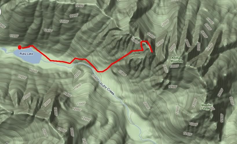 Aim for a major notch just west of the summit block. Animas is not visible in this photo. 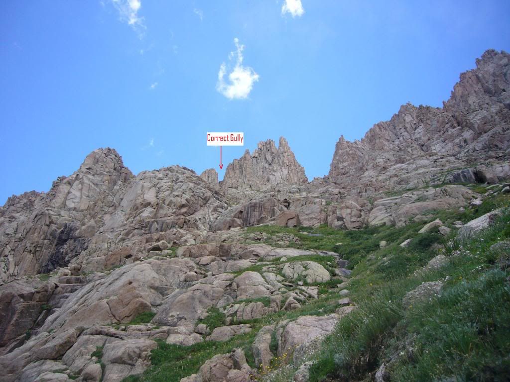 A View from 600' above the trail 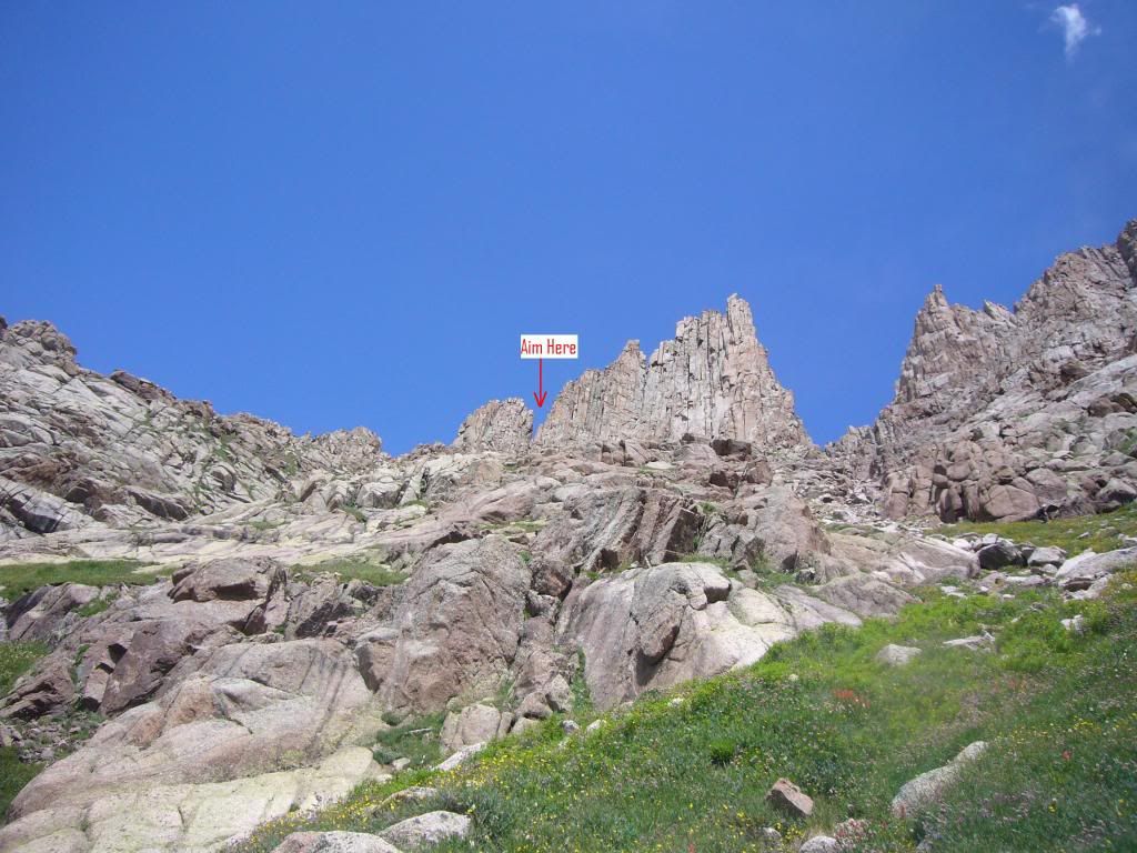 The critical gully will allow you to cross the WSW Ridge. This photo is marked from the descent perpective. You are still headed up! On ascent, a more direct line is preferable to avoid the sand. 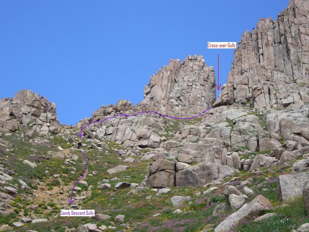 The gully will hold snow into August. There is a 15' cliff at the top that you may want to protect. 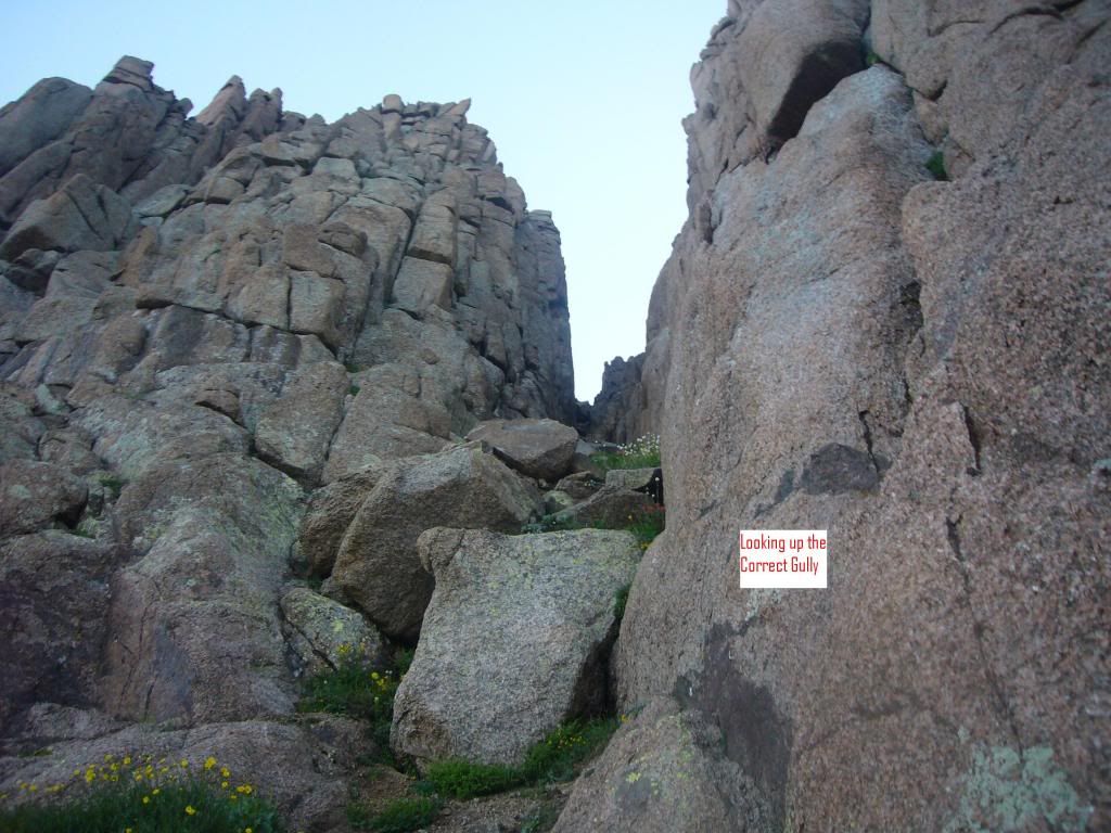 Once you clear the top of the gully, you break through the WNW ridge to surprisingly easy terrain on the West face. Climbing the West face to the summit block 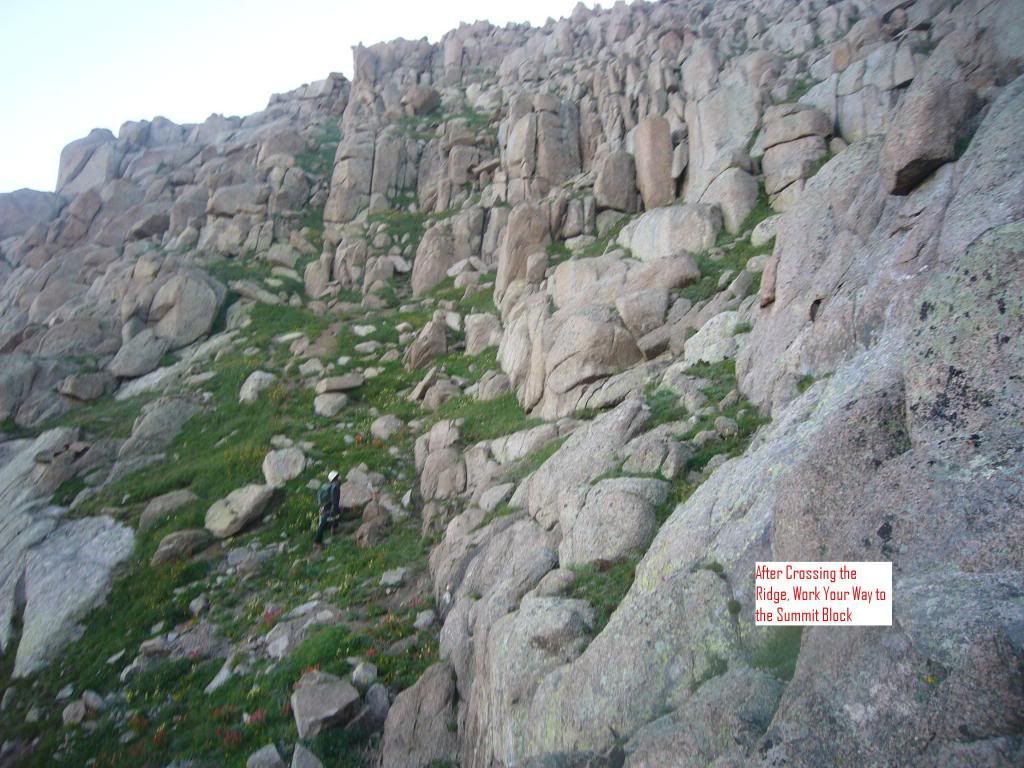 Working our way 250'up the West Face t the summit block 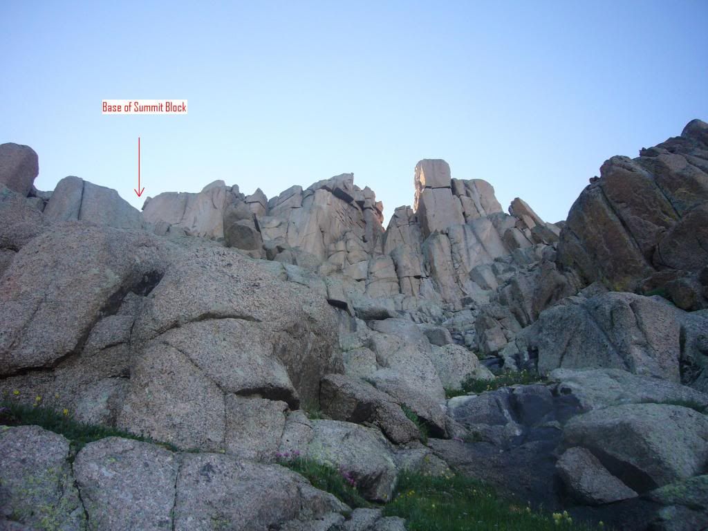 Still on the West Face, 200' below summit block 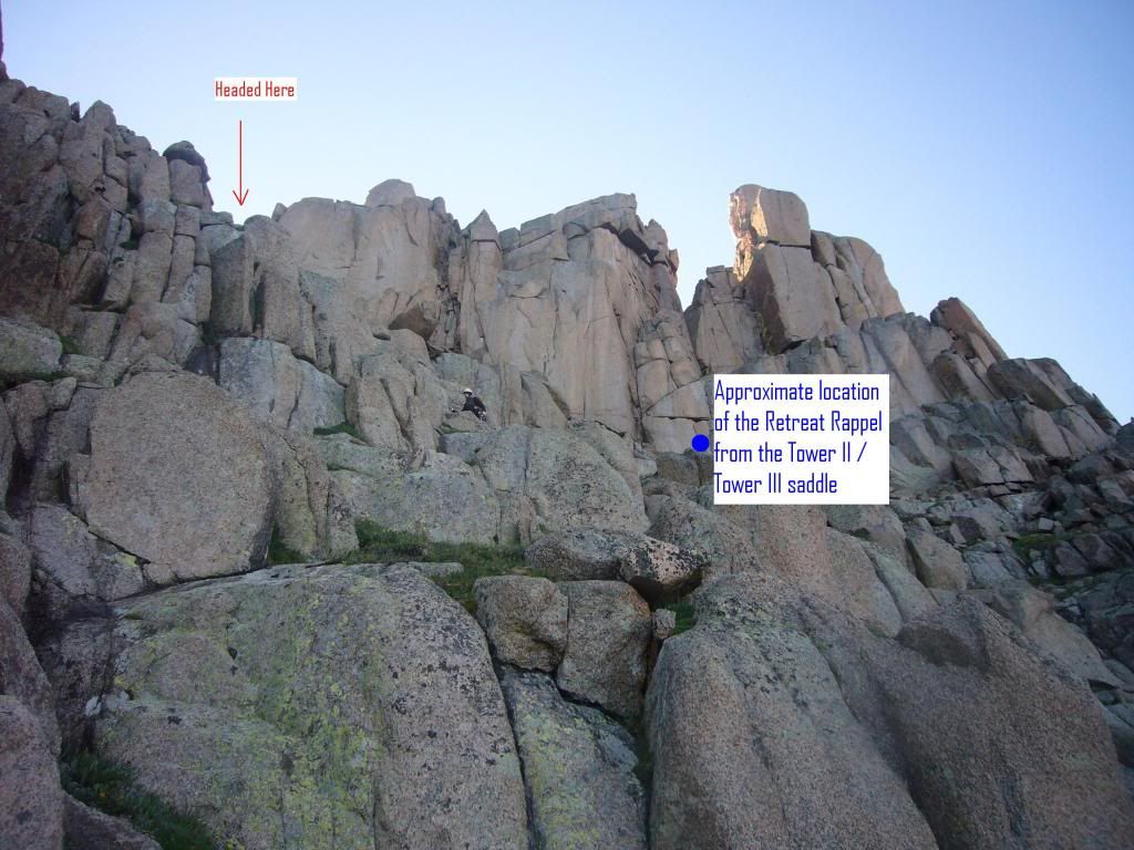 We reached the base of the summit block about 7:30AM; the trip took roughly three hours from Ruby Lake. At the base of the summit block, we took a 30 minute break to ready for the class 5 portion of the day. Having already solved most of the problems on Day 3, the first portions of the summit block went smoothly. Once prepped at the staging area for the summit block, Peter led onto the face of Tower I and used a convenient hand/foot crack to shinny through a rabbit hole that brings you to the base of Tower I . At the top of this 80' 5.5 pitch, he belayed me up to the tower's base. Though Peter had run right through, I had some trouble with the first 10' step onto the face. The rest of the climb through the rabbit hole to Peter's belay station seemed easy. The staging area and the first moved to the base of Tower I. Climb onto the face and sneek through a rabbit hole 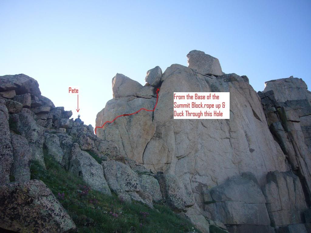 Once through the rabbit hole, Pete negotiated a 15' chimney to the base of the Tower I apex. Rather than summiting, he climbed left around the highest portion of the tower and landed at the tower I / Tower II Saddle. Pete, through the rabbit hole and at the base of the Tower I apex. He'll traverse left 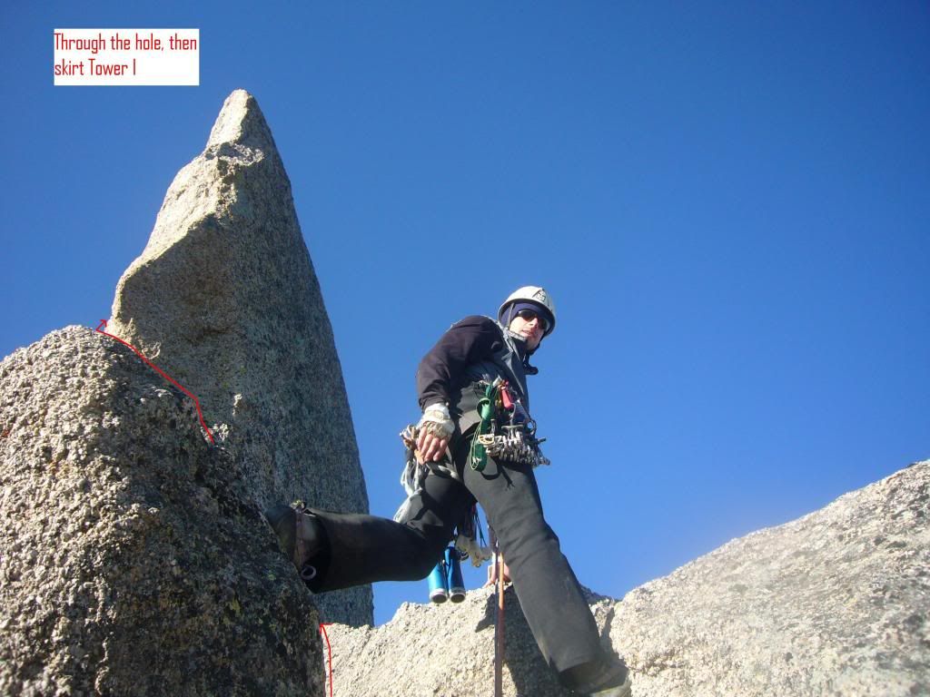 No need to top out on Tower I apex. Skirt left. 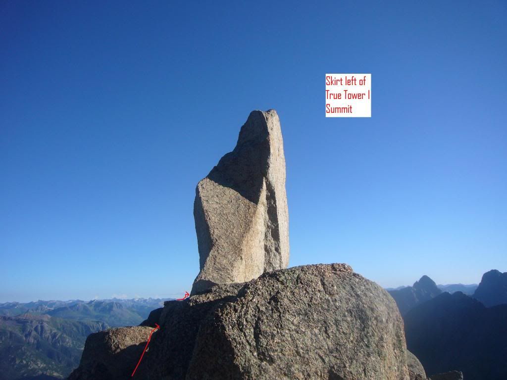 After skirting Tower I, the summit of Tower II is directly in front of your face. Rather that tackling the west face of Tower II, Pete chose a belayed 20' downclimb to reach the base of a crack which provides an alternative route to the Tower II summit. Pete spotted me from below with a top-rope belay through a rap sling and we set a new belay station at the base of the Tower II crack. In the photo below, look for Pete's helmet. The arrows indicate our downclimb on the left of the saddle and the crack route to the summit of tower II. Crack to the Tower II summit 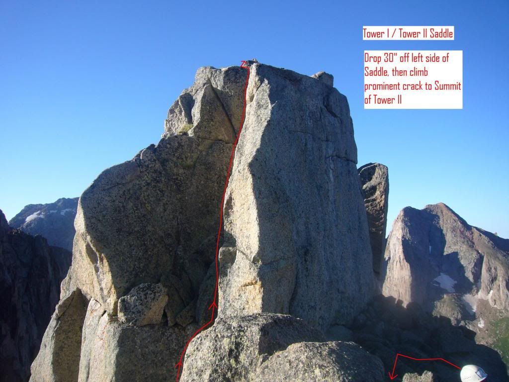 Pete finishing the crack to the tower II summit 5.7 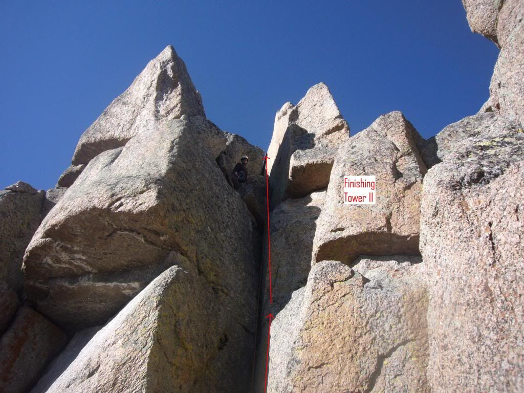 Upon completion of the Tower II crack, the climber finds himself on the true Tower II summit. At this point, Tower III and its problems are In Your Face. The tower is approximately 50' tall; it finishes with an extremely awkward 5.9, 25', off-width crack. Tower III, the Summit Crux 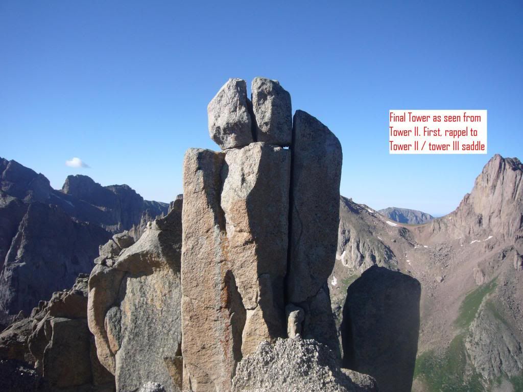 To reach the base of Tower III, you need to rappel 30' to the true Tower II / Tower III saddle. There is an old piton and another slung rock backs it up. The saddle is plenty wide and has several scattered pitons and slings for a belay station. Some also serve as rappel anchors for the final exit down the SW face. The view to the Tower II / Tower II saddle 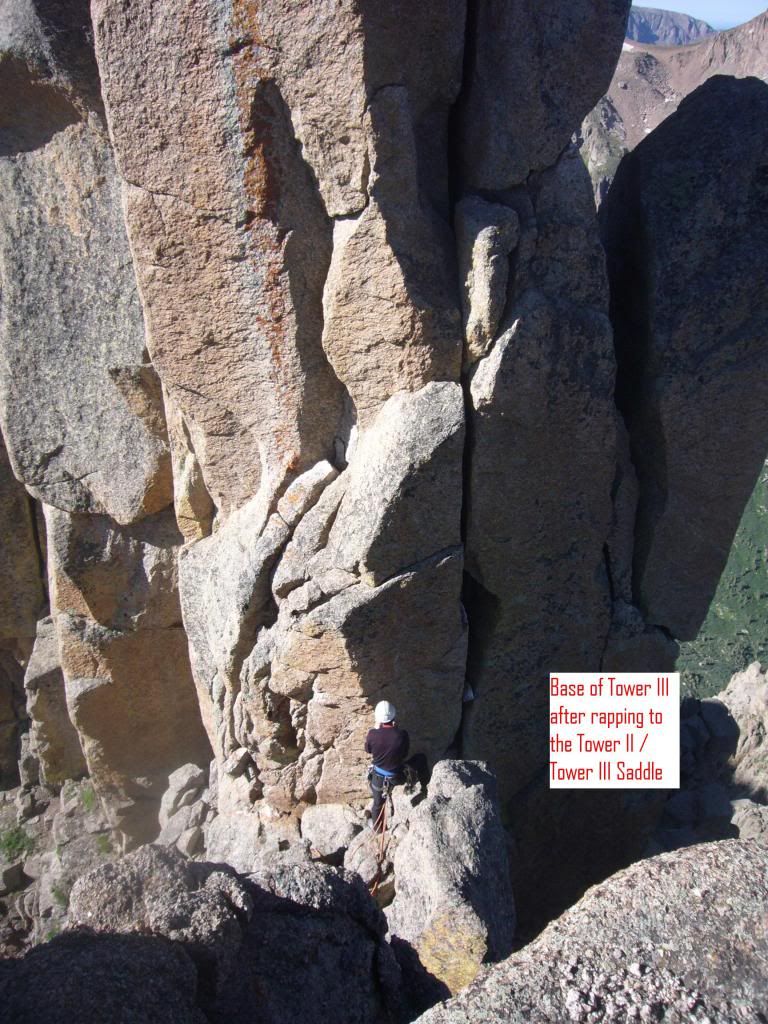 The 50' tall Tower III can be divided into three sections. The lower 1/3rd goes 5.6 and includes a round-about climb to leave and re-enter the major off-width crack. Lower route on tower III 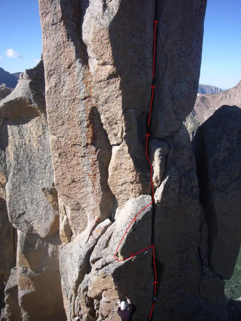 The middle section is not quite as off-width, so some folded joints will help a bit. Middle and upper two-thirds of Tower III 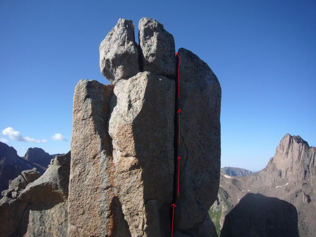 Peter on the final 15'. He gives it a 5.9 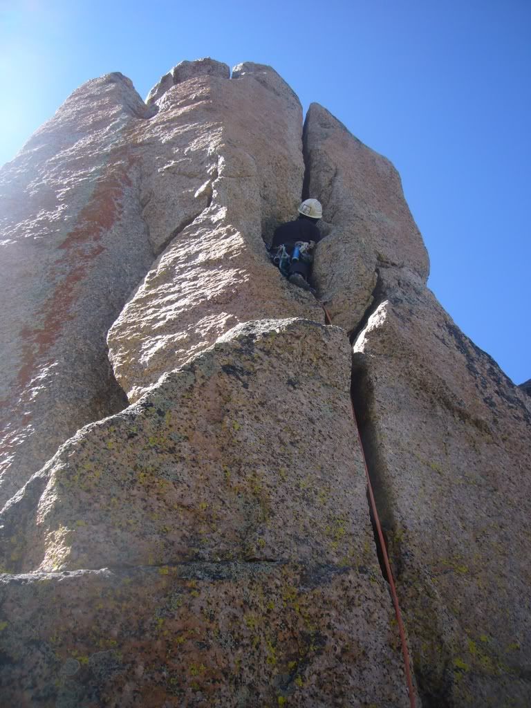 Properly protected, Peter finishes the final 15' that eluded him on day # 7. He set up a belay station and tried to quell my incessant anxiety that there wouldn't be enough room for the two of us to sit safely on the summit. Now, it was may turn. Never has there been such a pitiful display of climbing that actually resulted in a summit. Though Peter made the 5.9 moves, I was unable. On a tight rope, I got through the first 2/3rds, but then I went A-I. I had to grab the cams and pull up. Several times, I even walked the cams up the crack and pulled another few inches. My nerves were shot, my arms were shot, and several times I called out, "I can't do this; you'll have to lower me down!" Peter was quite the cheerleader and kept hauling. I'd yell "On the count of three, take ten inches" and I'd pull up with all the arm strength I had left. Peter finally retorted (paraphrased), "If that is 10", then I'm endowed w a 24" member!" Three feet from the top, there was a move that I should have been able to do without hauling on the cam and Peter encouraged me to go back to straight climbing, but I was so exhausted, I kept pulling on the pro. Twenty seconds later, I joined him on the summit of The Index. I was simultaneously excited and disappointed. I had summited a peak I'd been after for years. We had solved the route and pro problems and I knew that I'd be able to write and illustrate this TR, filling a large beta gap for Ruby Basin. But, my form had been so bad that I couldn't shake visions conjured by Hillary's supposed description of Tenzing "flopping about like a great fish" at the top of the Hillary step or the accounts that ".......in reality, Isabella Bird was dragged or hauled up the ascent (of Long's Peak) by the patience, skill and strength of Mountain Jim." Oh well, I wasn't wearing a skirt and even a comparison to a flopping Tenzing was admirable. I'll take it. There are two nice pitons positioned for a rappel to a landing just below the Tower II / Tower II saddle (on its north side.) A scramble back to the saddle allows the climber to setup for 2 short rappels down the west face to the ledges just under the summit block. Trace your ascent route back to the valley floor. Third short rap off the Summit Block 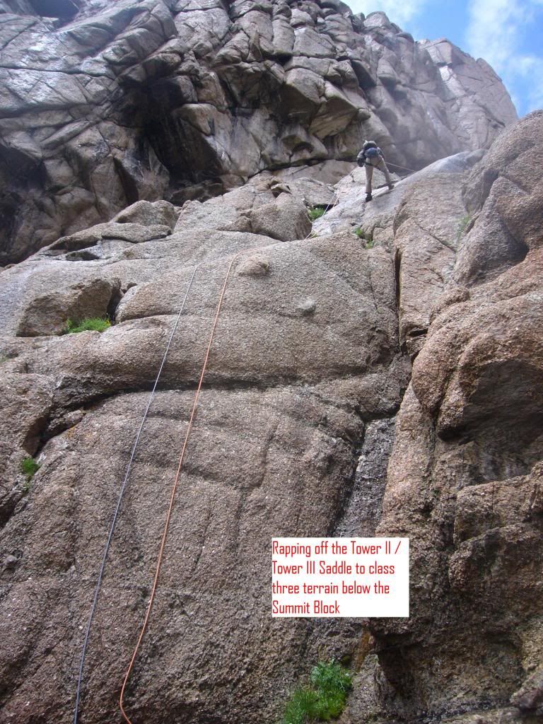 On the descent, watch for your exit back to the SE face. It was on the Day #3 descent that we found the couloir. There is a sling on a rock at the top if oyu want to rap the first 15'. 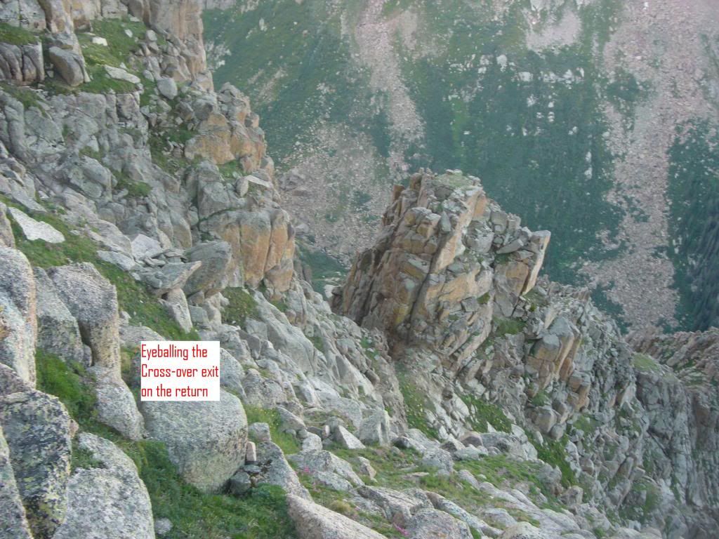 Looking down the gully from the short rap 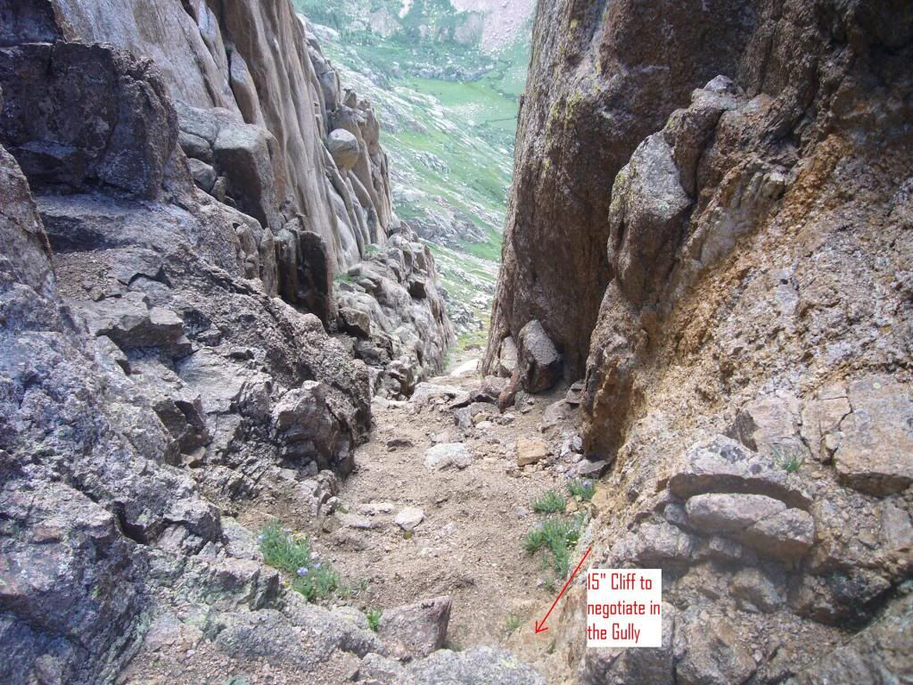 View Back up the Gully 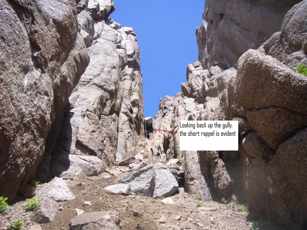 Day 12 Little Finger Route Description See Peter's Mountain Project Report for pro details from the leader's point of view. I was completely stoked about summiting The Index. I'd employed an unorthodox style (read: NO Style!), but had I pretty much expected that. Feeling confident, Pete wanted to take another stab at Little Finger. As you may recall (this TR is so long that you've probably lost track!), we had completed the first pitch of the climb on Day 5, but were unable to pull off the crux move. Pete definitely had renewed confidence and I wanted the peak, so we planned another attempt on Day 12. Just like day 5, we had no difficulties reaching the base of the climb. We left about 5AM and arrived at the base of the ascent couloir at dawn. The ascent couloir is sandy, steep, and, in places, loose. Unfortunately, it is much steeper than these photos imply. Route to the alcove on Little Finger 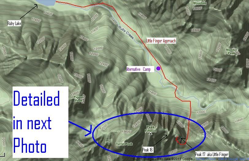 Panorama View: Turret to Peak 17 (aka : The Needles) 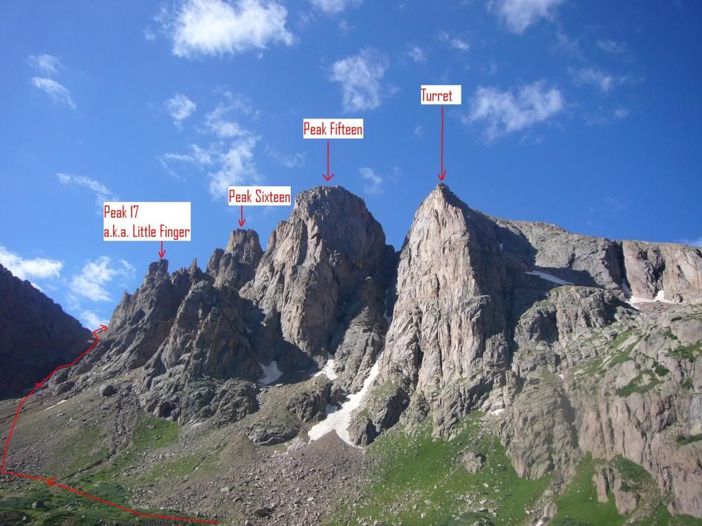 After passing through the Little Finger / North Eolus pass, the climber has two choices. Both are on the backside (south side) of the mountain; aim for the base of the first massif west of the saddle; it is only about 250 yards and 200' above. One choice employs a descending south-side traverse, moving 300 yards west while dropping 250 feet. Once around the base of a large loose gully, climb 350' up the perimeter of the gully's left side. The gully's shape will force you back toward the east, but continue to hug the left side until you can bend back west again. Another 100' of climbing will lead you to the SW corner of the Little Finger pillar. The gully's side consists of loose scree on slab and isn't particularly pleasant. As you reach the base of the climb, a broad pillar with at least two wide cracks appears in front of you. Climb up, aiming for the SW corner of the base of this pillar and look for a nice staging area located below the large western chimney (couloir?) that scars the south face of Little Finger. The second option begins at the same saddle, but does not give up any elevation. Traverse 60 yards west and 50' up to reach the base of a 12'wall. The key to this route is to locate a 20" cleft behind a large rock located above and to the right of the wall. After squeezing through this crack, continue on a westerly, slowly ascending traverse; you will be crossing the top of the same gully that the first option passed underneath. Reaching the Little Finger massif, pass under the south wall and eyeball the east and west cracks which run down its face. Head for the SW corner of the pillar. At the SW corner of Little Finger, look for a nice staging area at the base of the large western chimney that scars the south face of Little Finger. A significant alcove (the top of the first 50' pitch) is above your head. Drop your gear. A short jaunt around the left side of the peak and 100' up a sandy slope you will deliver you to the Peak 16 / Peak 17 (Little Finger) saddle. This saddle reveals airy views down the north cliff face to the camping meadows below. This side trip may help confirm that you've dropped your gear at the correct staging area. Peter stands in The Alcove. It is both the top of the first pitch and the base of the crux move 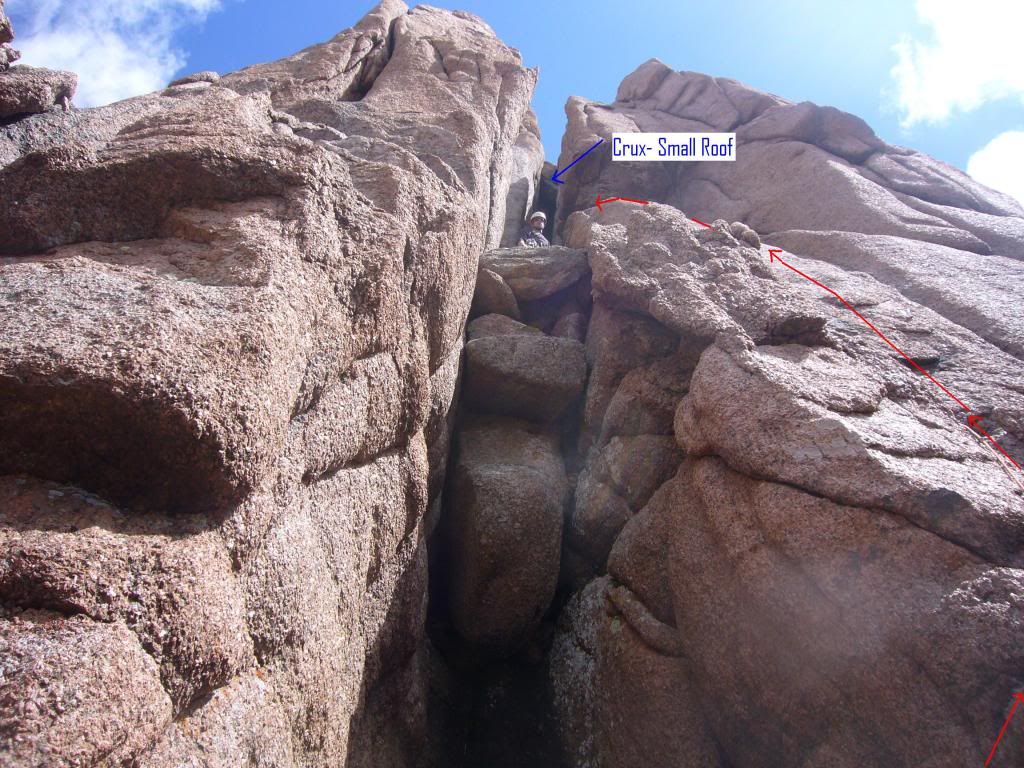 Peter quickly re-leads the 5.4, 50' climb to the alcove that he first led on Day 5 and I easily followed. Once neatly tucked into the substantial niche, the 5.8 crux presents itself. This is the spot where Marlyn and I had been foiled several years earlier and Pete and I failed one week ago. Today, however, conditions and attitudes were much improved. Four straight days of sunny weather had dried the wall in front of us. The moves that were covered in water last week provided holds that fingers and shoes could actually grip. Peter knew he could lead this pitch and I knew I could follow it (I actually HAD followed Tom Pierce's lead on this pitch a year ago, but we were turned back just short of the summit by uncertainty and impending darkness.) The Crux is a 18' wall defined on its sides by a chimney so off-width that stemming, when even possible, requires full body extension. It is a convenient place to be an NBA All Star. About 10' up the wall is a WWII era piton, firmly placed and seemingly able to hold the 8' leader fall that would save someone from hitting the deck. These 18' are a mixture of over-extended stemming and tiny hand/foot nubs that have a 50% chance of breaking off under stress. Pete found more pro placements than Tom had a year before, but all with the same verbal caveat that Tom had used, "This placement is sketch, but it may slow me down." Periodically, I'd hear a more welcome phrase. Maybe, "Ooooh, I like that one", but never "Now, there's a bomber piece." Shortly after making the first 18', the stemming becomes more reasonable. When about 40' of rope had been given out, Peter found a weakness in the right wall of the chimney that he used to leave the gully and create a stance on the rib which divides this west chimney from the east chimney 12' to our right. He exited the gully exactly where Tom had a year before. The stance between the two gullies still had last year's webbing and now has a new piece to boot. Seconding the crux went quite smoothly. I had seconded the same section last year under tom's lead and this year, I did a better job. Compared to yesterday, I was now climbing like Royal Robbins. Though held on a very tight string, I made most of the moves on my own. At least I FELT like I was making them on my own! From the stance on the rib which separates the two chimneys, the leader has two choices. Last year, Tom continued straight up the separation rib (really a face at this point) and found a belay stance 100' above. Here the rib intersects the east chimney. Peter, instead, dropped east, 5' off the rib, and rounded a corner which put him directly in the east chimney. He ran the rope up the chimney and set his belay stance at exactly the same place that Tom had used. Now, both leaders stood in the loosely defined upper east chimney. I was able to efficiently follow both leaders, but I preferred Peter's 5.4 route. Some easy stemming allowed both leaders to take the rope another 30' to a belay stance where the gully re-defined itself as a true chimney. The belay stance that was set here marked the high point of last years trip. An enormous chockstone creates a roof 25' overhead. Peter guessed that the route continued up this chimney and that upon reaching the chockstone, he'd find a way to climb over it using the crack created where the chockstone butts up against the left wall of the chimney. Peter was able to place his back against the left wall and work his way to the base of the chockstone. In order to negotiate the roof created by the stone, he moved to the front of the chimney and scooted on up. However, over the top of the roof, other chockstones appeared. Here, he faced the stones and jammed his hands and feet into the intersection crack. With one committing move, he climbed over the top of the highest stone and belayed me from a few feet left and above the final block. Again, I was able to make the moves w/o complete embarrassment. Peter relaxes in the Upper East Chimney, just under the Chockstone Roof 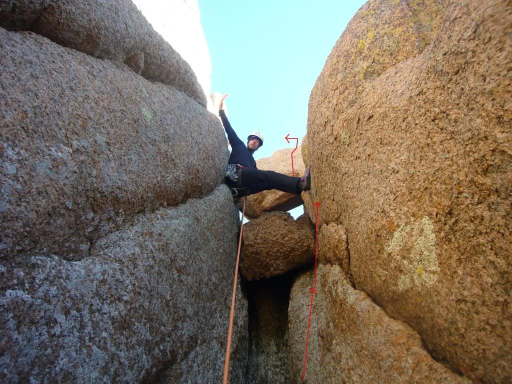 Yesterday, Peter had encouraged me to finish the route with style, but I had let him down by continuing to pull up on the gear. Today, I was having much more fun. I didn't have the feeling that I'd been "hauled" up the mountain. So, when Peter encouraged me to lead the final pitch to the summit, I was game. This short 5.3 pitch toys with a 2000' fall on its north side (but only 200' of fall on the other 3 sides). Thanks, Peter Steve Leads the Final Pitch to Little Finger 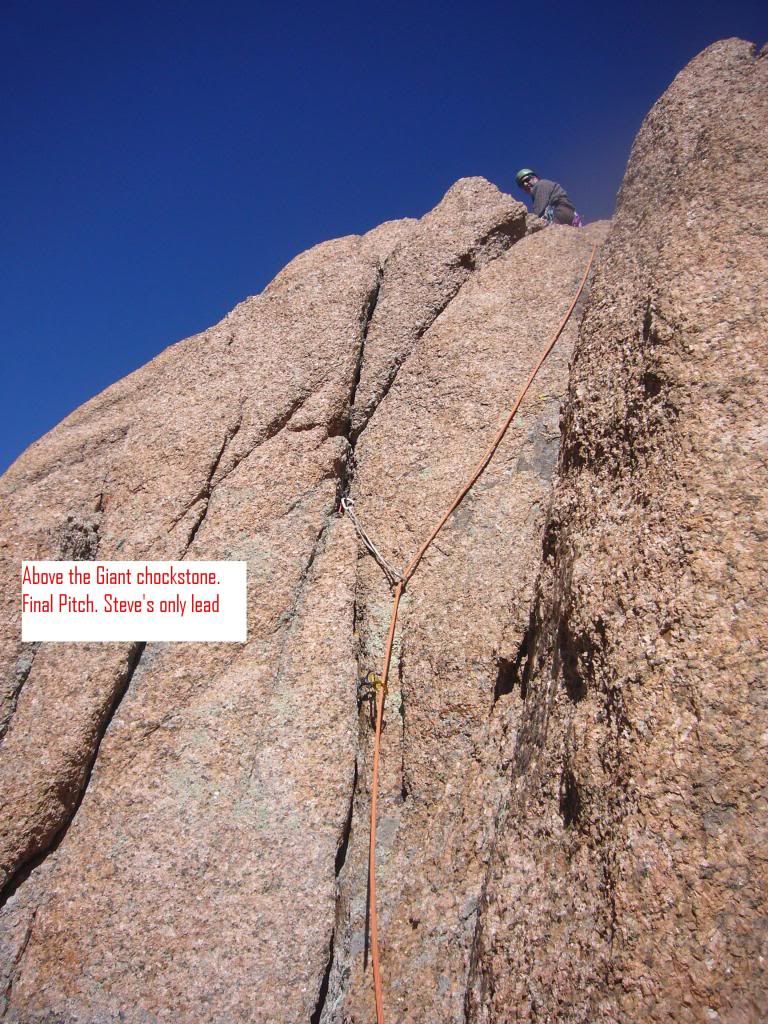 The register jar is stashed in a 4' wide seat a few feet from the true high point. It was 10:45. We were 5 � hours out from our Ruby Lake camp. A short belayed scramble allows the climber to walk around the back of the final crumbling pillar to sit atop the sphincter-scratching apex. Steve's Victory Photo 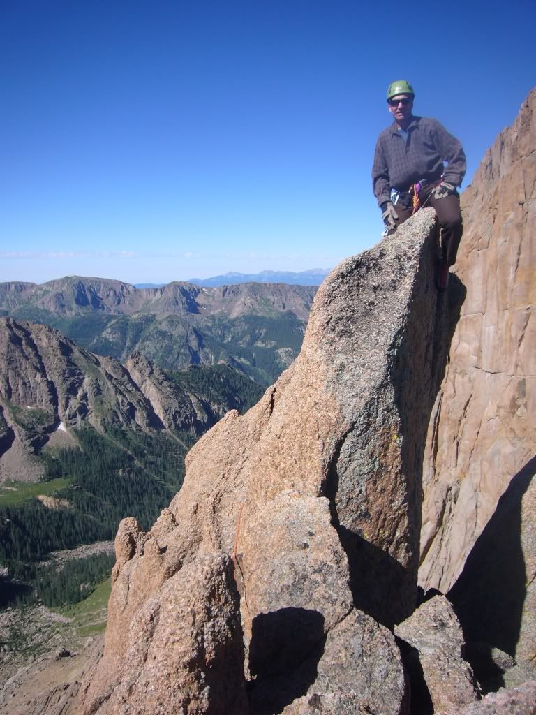 The descent is enjoyable and easy. You can rap directly off the summit and straight down the west chimney. There is no need to switch back and forth between chimneys. Even with the tag line, are short ropes necessitated 3 raps, but otherwise, we'd have spent the lat twelve days hauling around full-sized roped when half-size was more appropriate. Peter had a strong desire to attend an important family function the next day. His sister and brother-in-law in Durango would be appreciative but they knew that he might not be there. Ready to rap off the summit at 11:20AM, we decided to make a Persephonean effort to reach the train at Needleton by 3PM (similar to a Herculean effort, but modified to fit situations where the effort is expended on behalf of your sister.) We had our ropes, climbing shoes and pro stashed by 11:30AM, made our way to the descent saddle by 11:45, and reached our Ruby Lake camp at 12:30. We broke down our stench-filled tents from their 12-day perches and had all our gear crammed into the "big packs" 10 minutes later. At 12:45, we were stepping out of camp. Humping it like a lascivious Chihuahua on great Aunt Tillie's hosiery-covered calf, we flew down the trail bound for the station. We stopped only once in order to retrieve a six-pack stashed in a side stream 300 yards from the train stop. Arriving at 2:15PM, we'd managed to cover the trail a half-hour faster than we had with our empty packs on out Day 8 retreat. Conversing with the other climbers waiting to chug on into Durango, we were reminded that the "3PM" stamp on our return ticket referred to the train's departure from Silverton. It wasn't expected at this stop until 4PM. With a few beers on board and an hour and a half to kill, I snuck a bit downstream to find a skinny-dipping hole. Not that I'm an exhibitionist, but I knew I'd toned my one-pack (in contrast to Taylor Lautner's famous werewolf six-pack.) Twelve 3000'+ days of Class 3 to Class 5 scrambling all while foregoing Twinkies had left me 10 pounds lighter. Not to worry, I've replaced them with 12 new pounds. We boarded the train on time and arrived back in Durango in time for Peter to join his sister for a Pizza run. In the morning, I stopped at the coffee shop and later handed off two pounds of fresh ground to Peter who delivered them and the borrowed cams to our gracious benefactor. Originally, our Weminuche expedition had loftier goals. Exploration of the No-Name, Sunlight basins were planned, and Sunlight Spire was intended to, as a minimum, get a good recon. Still, the 12 day revised trip was satisfying. Peter had summited the cirque of ranked 13ers and lead two of the hardest (arguably the hardest) climbs on the list of named, un-ranked 13ers. Also, not insignificantly, I still have good reason to plan another Weminuche expedition: the penultimate Colorado climbing experience. |
| Comments or Questions | ||||||||||||||||||||||||||||||
|---|---|---|---|---|---|---|---|---|---|---|---|---|---|---|---|---|---|---|---|---|---|---|---|---|---|---|---|---|---|---|
|
Caution: The information contained in this report may not be accurate and should not be the only resource used in preparation for your climb. Failure to have the necessary experience, physical conditioning, supplies or equipment can result in injury or death. 14ers.com and the author(s) of this report provide no warranties, either express or implied, that the information provided is accurate or reliable. By using the information provided, you agree to indemnify and hold harmless 14ers.com and the report author(s) with respect to any claims and demands against them, including any attorney fees and expenses. Please read the 14ers.com Safety and Disclaimer pages for more information.