| Peak(s): |
Torreys Peak - 14,272 feet Grays Peak - 14,275 feet La Plata Peak - 14,344 feet Mt. Princeton - 14,200 feet Mt. Antero - 14,271 feet |
| Date Posted: | 08/23/2011 |
| Modified: | 07/05/2012 |
| Date Climbed: | 08/17/2011 |
| Author: | mike_kadow |
| Peak(s): |
Torreys Peak - 14,272 feet Grays Peak - 14,275 feet La Plata Peak - 14,344 feet Mt. Princeton - 14,200 feet Mt. Antero - 14,271 feet |
| Date Posted: | 08/23/2011 |
| Modified: | 07/05/2012 |
| Date Climbed: | 08/17/2011 |
| Author: | mike_kadow |
| Kelso Start to this 5 in 5 |
|---|
Season's Goal SurpassedTwo years removed from hiking, I was finally able to put a good season together. The season's goal was to add nine new 14ers to my six for a nice round number of 15. This trip put me at 16. The following are the recent four hikes. This is my first "official" trip report so bear with me. It's straight forward; nothing creative or humorous. Kelso Ridge - Wednesday, August 17 Fellow forumer, Jon, expressed a desire to hike his first 14er. I invited him over to talk about them. He seemed eager for something adventurous as was I. The standard route seemed too tame for our tastes. To make a long story short, he convinced me through no pressure of my own that he would be fine with exposure. Two nights later we were driving to Grays TH.   Weather and temps were fair all day - cool and breezy on the summits. Jon did great throughout. First timers can be iffy, but I felt confident in his ability.   Admittedly, I made what I consider a rookie mistake. Having never gone this route, I didn't realize how close we were to the "knife edge" already and I led around climber's left and hit that dead end. While I'm sure many people have "climbed out" from this dead end, there was no way we would even think about trying it. Those of you who have been to this dead end know what I'm talking about - there isn't much room for error to climb up here. Not knowing how to time out the "technical" aspects of Kelso for an itinerary, I gave us a conservative time of five hours. It took us almost four. Gaining Torreys' there were three pairs of hikers via Kelso and a handful of people on the summit. Heading over to Grays' I was reminded why these peaks are popular - relative hiking ease and proximity to towns and cities - I've never seen so many hikers on a 14er before. I would not want to be there on a weekend. Jon set his own pace back to the car (via standard route) and I arrived about an hour later - chatting a bit on the way down, snapping pictures, plus I REALLY wanted to get a shot of me on the rock outcropping.  Original itinerary had us at a conservative "first timer outing" of nine hours. Jon finished in six and is looking forward to more. **Pics from June 2012 trip at bottom. La Plata Peak - Friday, August 19 Leaving Denver at a late 9:15am, the weather forecasting 50% thunderstorms the next three days, the weekend looked iffy. Nate and I had been planning this for six weeks as what could be our last 14ers of the season. Parked at the 2nd closest parking area to the trailhead (what seemed about 200' from the TH). Started hiking at 12:15pm under overcast skies, but nothing ominous. Motivated by the weather we arrived at the summit in 2 hours 15 minutes, over one and a half miles an hour was pretty quick for us.  The summit weather couldn't have felt better. There were strong misting clouds around the other peaks and patchy sun on others. We wanted to stay longer, but had to set up camp at Mt. Princeton before the rains came. We got a few dozen mist droplets on the summit, but never felt threatened. Never saw lightning or heard thunder; being the 5th tallest, we could see far enough and nothing close to menacing. Descended in 1:50.    Some notes: there were some boggy/muddy areas at the base of the initial big incline. On our way up, we saw some young teenagers trying to "turf glissade" down the sandy/gravel stuff. While entertaining to watch, it could not have felt good. I figured they were tired, especially of loose stuff. Mt. Princeton - Saturday, August 20 Driving up the road rather late, all of the treed campsites were occupied and we secured the next open one around 11,280' at the apex of a hairpin. It was far from ideal, but a campsite (with a fire ring) nonetheless. It looks out over the valley to Buena Vista and up at Princeton. The grass to speak of is not level, but there was enough flat area for our two tents and another if need be.  Hit the trail at 6:00am and saw a couple more places one could camp before the trail turnoff.  Weather was good. We missed the switchback turnoff only realizing this when we reached the loose dirt. Confirmed by GPS, we decided to scramble straight up. If you like scrambling, this is no problem. Nate summitted exactly 2:15 like the day before and I came in 15-20 minutes later. Note: the summit push contains a fair amount of loose gravel and can be tempting to wander off around it like these eight guys that spread out right. The guys eventually made their way back to the trail, but with time and elevation loss. ") If there's one word to describe Princeton, I'd say "rocky". Mt. Antero - Sunday, August 21 Drove up to about 11,400' and found a nice campsite hiker's left close to a stream. There's also another campsite directly on the other side of the road roughly 125' and close to another stream. The road is as described, but good clearance 4wds should have no problem. We had a Jeep Liberty and to be on the safe side, we did move some rocks around to be sure we'd clear. Restless, we began hiking at 4am instead of 6. The road to the start of the switchbacks seemed steep. I'd attribute this to starting a hike on an incline and being worn from the previous two hikes. The switchbacks were a welcomed relief as they have less gradient.   Nate hit the summit in 2:20 and I came in 5 minutes later. While I'm impressed with our times of these last 3 hikes, I mention them only for others' reference. I gauge myself comfortable ascending on average 1mph per mile per 1000' gained, regardless of distance. These last three hikes were under 1000' gained per mile, thus the increased speed/more ground covered, etc. And being motivated by bad weather always seems to get an extra bounce in your step! ")  Needless to say, we were both happy the weather cooperated throughout the weekend. Cheers! and thanks for reading. And if anyone has any questions, please feel free to contact me. Addition: We recently did Kelso Ridge again (6/13/12) and here's another perspective of the Knife. 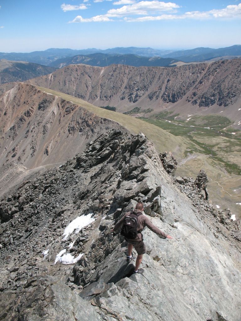 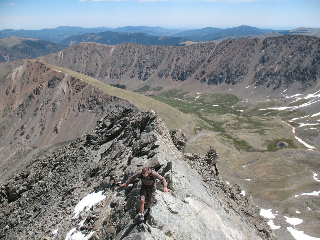 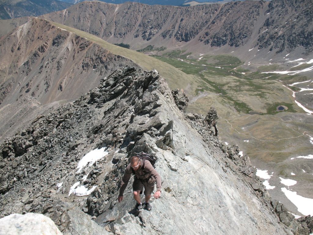 Thumbnails for uploaded photos (click to open slideshow): ")
 Jon looking comfortable")
 Fairly stable rock")
")
")
 Yes, I'm able to get away with cotton - I guess I don't sweat much.")
")
")
")
")
")
")
 Hard to see, but there are four pairs of hikers dispersed at center and some even right of center (powder blue coat)")
")
 (I need tips on shooting alpenglow.)")
")
|
| Comments or Questions | ||||||
|---|---|---|---|---|---|---|
|
Caution: The information contained in this report may not be accurate and should not be the only resource used in preparation for your climb. Failure to have the necessary experience, physical conditioning, supplies or equipment can result in injury or death. 14ers.com and the author(s) of this report provide no warranties, either express or implied, that the information provided is accurate or reliable. By using the information provided, you agree to indemnify and hold harmless 14ers.com and the report author(s) with respect to any claims and demands against them, including any attorney fees and expenses. Please read the 14ers.com Safety and Disclaimer pages for more information.