Download Agreement, Release, and Acknowledgement of Risk:
You (the person requesting this file download) fully understand mountain climbing ("Activity") involves risks and dangers of serious bodily injury, including permanent disability, paralysis, and death ("Risks") and you fully accept and assume all such risks and all responsibility for losses, costs, and damages you incur as a result of your participation in this Activity.
You acknowledge that information in the file you have chosen to download may not be accurate and may contain errors. You agree to assume all risks when using this information and agree to release and discharge 14ers.com, 14ers Inc. and the author(s) of such information (collectively, the "Released Parties").
You hereby discharge the Released Parties from all damages, actions, claims and liabilities of any nature, specifically including, but not limited to, damages, actions, claims and liabilities arising from or related to the negligence of the Released Parties. You further agree to indemnify, hold harmless and defend 14ers.com, 14ers Inc. and each of the other Released Parties from and against any loss, damage, liability and expense, including costs and attorney fees, incurred by 14ers.com, 14ers Inc. or any of the other Released Parties as a result of you using information provided on the 14ers.com or 14ers Inc. websites.
You have read this agreement, fully understand its terms and intend it to be a complete and unconditional release of all liability to the greatest extent allowed by law and agree that if any portion of this agreement is held to be invalid the balance, notwithstanding, shall continue in full force and effect.
By clicking "OK" you agree to these terms. If you DO NOT agree, click "Cancel"...
June 18, 2011
Mt. Sneffels Snow Climb via Lavender Couloir
Trailhead: Yankee Boy Basin Lower Trailhead
Round Trip Mileage: 6.0 miles supposedly - seemed much longer!
Start Time: 6:30 am
Return to Trailhead: 3:30 pm
We left Colorado Springs on Friday afternoon at approx 4 pm, stopping in Gunnison, CO for an "authentic" Mexican meal (that's what the sign said, anyway). We continued to Ouray, CO and then on CR 361 to Yankee Boy Basin. We could not find any available camping spots along the route so we continued all the way to the lower trailhead parking area (11,350'), arriving at midnight. We managed to sleep in our car a little over the next few hrs. and ignored the initial signs of daylight, finally rising at 5:45 am.
The road is clear to the lower trailhead where the restroom is located and we encountered no snow to that point. The last mile or so requires 4WD and higher clearance. A large snowdrift blocks the road at that point and there is still substantial snow between the lower and upper trailhead. I would guess that the upper trailhead will not be accessible for a few more weeks.
After arranging our gear and having something to eat we finally hit the trail at 6:30 am - about an hour later than we intended. We found the conditions to be perfect for our climb, with none of the rain/snow forecasted for Friday night.
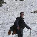
Starting out at Yankee Boy Basin trailhead
There were four in our climbing party, two middle aged men, a middle-aged woman and the youngster of the group, a 13 year-old young man who would surprise us all this time with his adroit mountaineering skills.
The early morning hike was pleasant, but we were all surprised and a little concerned at how soft the snow was. After some early postholing we put on our snowshoes and continued at a leisurely pace, enjoying the Yankee Boy Basin and the spectacular views of Kismet Mountain (13,694').
Kismet Mountain
We finally reached the upper trailhead and then continued northwest for another 1/2 mile till the trail angled north to the very broad Lavender Couloir.
Our first look at the Lavender Couloir
Already the snow was quite soft, which significantly impeded our progress up the couloir. The sun was bright and the skies clear, and it was warm enough at this point to shed layers, all the way down to a short-sleeved shirt and jacket. We put on our crampons and slowly made our way up the couloir to the saddle (13,560').
Halfway up the Lavender Couloir
View from the saddle (13,560')
Here we got our first glimpse at the steep, narrow couloir to the summit block.
Looking up at the steep couloir to the summit block
Here we took an extended break and consulted with a couple climbers, including one who turned back at this point because of the soft snow conditions in the couloir. One of our party decided to turn back, due in part to a nagging pain in the knee. The three of us continued on, encouraged by the sight of climbers ahead of us who seemed to be managing quite well.
We made slow, careful, steady progress up the couloir, taking care to leave plenty of space between the three of us. The youngest climber (13) amazed us with his speedy ascent while we two older men climbed much more slowly.
The couloir narrows as you approach the summit and gets quite steep at times. I'm guessing 45 degrees, but perhaps one of you readers has a more accurate estimate of the slope here?
Nearing the top of the couloir
At the top of the gully there is a "V" notch and there we met a middle-aged woman who was making her way down from the summit. I was surprised that she made the climb without crampons - just boots and ice axe.
We made our way through the narrow notch, then turned sharply to the right and scrambled up to the summit, finally arriving at 12:30 pm.
Finally at the summit!
The weather was absolutely perfect and we lingered for quite a while, enjoying a hard-earned summit view.
The snow continued to soften which required a very careful descent down the couloir. I stopped many times and enjoyed the indescribable views of the San Juans.
Breathtaking views
We were relieved to reach the saddle and then enjoyed a few glissades down the Lavender Couloir. The snow was so soft at this point that our glissades were frequently interrupted as we had to pull our rear ends out of the deep holes in the snow. Finally we gave up glissading altogether and made the slow walk back to the trailhead.
The route description indicates 6.0 miles roundtrip. We had quite a discussion about this. Either the length is significantly understated or this is the longest 6-mile hike of my life! I'm sure the soft snow conditions made it seem even longer. We finally returned to the trailhead at 3:30 pm, after taking a couple more stops on the way down.
We enjoyed quite a laugh when a family of four from Texas strolled by in their shorts and sneakers. We exchanged pleasantries and I enquired where they had been hiking. When they said they had made it "almost to the top of Mt. Sneffels" I was amused and kindly explained to them where Sneffels was located and what the conditions were like. They had been hiking just an hour or two but stuck to their guns - they had been nearly to the top of Sneffels, turning back just before the summit. They were a bit offended that I didn't buy their story. Whatever!
What a fabulous day! - one I will enjoy remembering for a long, long time, and one that I hope to repeat on another sunny, clear day in the San Juans somewhere down the road.
Can't beat springtime in the San Juans.
The narrow road to Yankee Boy Basin.
Thumbnails for uploaded photos (click to open slideshow):
Good to share Mt. Sneffels with you all last Saturday. Opted for Telluride over Moab but will be sure to take your advice when I eventually make it out there. Kudos to Candace (?) (of the CMC) -- who was certainly my inspiration that day. Still amazed that she did the couloir in snowshoes rather than crampons. And I agree -- the hike out seemed like the longest six miles I've hiked in a while.
nkan, snow conditions appeared to be changing rapidly. It will depend on the weather the next couple weeks. I recommend an EARLY start - we set out at 6:30 and that was at least 90 minutes later than we should have, but after arriving past midnight we were slow getting up in the morning.
for posting this report, very helpful. I wonder if the snow will stay until July 4th weekend though, when we plan to be there.
Caution: The information contained in this report may not be accurate and should not be the only resource used in preparation for your climb. Failure to have the necessary experience, physical conditioning, supplies or equipment can result in injury or death. 14ers.com and the author(s) of this report provide no warranties, either express or implied, that the information provided is accurate or reliable. By using the information provided, you agree to indemnify and hold harmless 14ers.com and the report author(s) with respect to any claims and demands against them, including any attorney fees and expenses. Please read the 14ers.com Safety and Disclaimer pages for more information.
Please respect private property: 14ers.com supports the rights of private landowners to determine how and by whom their land will be used. In Colorado, it is your responsibility to determine if land is private and to obtain the appropriate permission before entering the property.


")


 Starting out at Yankee Boy Basin trailhead")
 Kismet Mountain")
 Our first look at the Lavender Couloir")
 Halfway up the Lavender Couloir")
 View from the saddle (13,560')")
 Looking up at the steep couloir to the summit block")
 Finally at the summit!")
 Breathtaking views")
 Can't beat springtime in the San Juans.")
 The narrow road to Yankee Boy Basin.")
 Nearing the top of the couloir")