Download Agreement, Release, and Acknowledgement of Risk:
You (the person requesting this file download) fully understand mountain climbing ("Activity") involves risks and dangers of serious bodily injury, including permanent disability, paralysis, and death ("Risks") and you fully accept and assume all such risks and all responsibility for losses, costs, and damages you incur as a result of your participation in this Activity.
You acknowledge that information in the file you have chosen to download may not be accurate and may contain errors. You agree to assume all risks when using this information and agree to release and discharge 14ers.com, 14ers Inc. and the author(s) of such information (collectively, the "Released Parties").
You hereby discharge the Released Parties from all damages, actions, claims and liabilities of any nature, specifically including, but not limited to, damages, actions, claims and liabilities arising from or related to the negligence of the Released Parties. You further agree to indemnify, hold harmless and defend 14ers.com, 14ers Inc. and each of the other Released Parties from and against any loss, damage, liability and expense, including costs and attorney fees, incurred by 14ers.com, 14ers Inc. or any of the other Released Parties as a result of you using information provided on the 14ers.com or 14ers Inc. websites.
You have read this agreement, fully understand its terms and intend it to be a complete and unconditional release of all liability to the greatest extent allowed by law and agree that if any portion of this agreement is held to be invalid the balance, notwithstanding, shall continue in full force and effect.
By clicking "OK" you agree to these terms. If you DO NOT agree, click "Cancel"...
La Plata and East LP Via SW Ridge With a Gang from 14ers.com
Participants (Those who were with our group at least part of the day): SpringsHiker, globreal, Waggs, kushrocks, keystone4me, FCSquid, and speedyturtle, along with 3 friends of keystone4me. I know Beagle and Paula were there but I don't believe we met up on the trail.
After 43 summits I am long overdue for a trip report so here is my first one!
Conditions for hiking overall were very good but there is a LOT of snow in the basin. We encountered snow off and on from 11,200 through 12,300 and there is a great deal of water and boggy, soggy ground throughout the entire basin. The ridge out of the basin still has a lot of snow but it is mostly avoidable.
There was a bit of confusion among participants about our camping location in Winfield, the road to the TH (easy to miss the right turn required to go up the last hill before the TH) and even regarding where the TH begins. This strung hikers out over the starting area as we did not all know each others' locations. Five of us managed to start out together at 5:45 and were followed by a few other groups over the next 30-45 minutes.
Our group was joined by others and we bunched up or spread out at times. At one point in the basin there were 11 of us and 2 dogs.
8 of us and 1 dog crossing one of the drier portions of the basin
Climbing out of the basin to the first ridge included crossing some short snowfield sections but it was much better than crossing the basin. This was the one and only snowfield where we had to kick steps for the entire day.
Climbing out of the basin, mostly avoiding snow
As we gained the ridge and looked back we saw clouds moving in around from all directions. Sayres Benchmark is the prominent peak.
Sayres Benchmark. Clouds moving in. You can see others in our group along the trail on the ridge.
As we neared the talus-covered slope on our way to the 2nd ridge, clouds were moving in, bringing colder air and gropple, most of it bouncing off but occasionally hard when it was wind-driven.
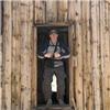
Gearing up
Looking down from the summit you can where we crossed the 2nd ridge, from left to right. If you look closely you can see one climber traversing near the edge of the snowfield. Sayres Benchmark is the peak on the left side in the background.
Summit group shot! The weather cleared just for a bit and five of us were able to get a group shot. FCSquid joined us on the summit minutes after this photo was taken.
LtoR: keystone4me, SpringsHiker, Waggs, kushrocks, globreal. You can just see Boomer (l) and Sophie the Super Dog (r)
As we started out for East La Plata (ELP) we had to drop down a steep snowfield.
Waggs starting down the snowfield on the way to ELP
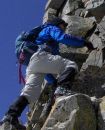
Four of us, myself, globreal, Waggs and FCSquid headed over to ELP and a little bit of technical fun on the short, 0.21 mile traverse. Sustained class 3 with a few class 4 moves.
View toward ELP along traverse
As we got out of the initial snow near the LP summit we started to encounter the rocky part of the ridge.
Waggs and SpringsHiker Moving Along the Traverse to ELP
The longest and hardest snow hit while we were nearing ELP. Our shot on the summit of LP was quick and we were on our way back.
SpringsHiker, FCSquid, and Waggs. (Thanks for the quick pic Britt!)
Looking back at the LP summit on our return. keystone4me was kind enough to wait for us and maintain radio contact as none of us knew how much more hard snow was to come. Fortunately the snow stopped shortly before we returned to the LP summit and the skies cleared for good.
Probably the crux of the route, we opted for a shorter, but tougher class 4 move here rather than skirt the rock formation down lower around the right side. The next two pictures show us making this move.
Waggs making a nice class 4 move
SpringsHiker on the same spot, with FCSquid providing guidance
As the skies cleared we stopped for some pics on the ridge.
Great mountaineering pic of Britt! (globreal)
Doggler was making his way up Ellingwood ridge during this time and we just missed him on the summit. He provided this great pic of the LP summit as he moved closer on the ridge.
Our return into the basin allowed for several nice glissades although it was a wet, slushy mess. Tracking through the basin on our way out was so wet it left everyone with completely soaked feet, but we did pretty well keeping postholing to a minimum. Only occassionally did I hit a posthole up to the waist.
We stripped down layers twice after reaching the basin. The lower portion of the trail around 11,300 was sunny and warm.
Kevin nearing the end of the hike
The basin to the west was beautiful with all the snow and blue skies. The afternoon weather in Winfield was just beautiful.
We were sorry that we missed a few other 14ers people at the start of the day. A few turned back due to missing the TH or concern over conditions, i.e. weather, postholing, etc. For those of us making it to the top it was a rewarding summit. Congrats to Waggs on his 4th 14er! And Britt for finally nailing ELP!
Credit for photos in this TR go to SpringsHiker (Scott), Waggs (Rob), globreal (Britt) and Doggler (Sean). kushrocks (Ryan) forgot his camera in the car--at least we could help him provide evidence of his successful summit. It was also great to meet up and hike with keystone4me (Adam), FCSquid (Phil) and speedyturtle (Paul), along with Adam's friends Kevin, Jamie and Erica. It was a great group to spend a day with on 14ers!
Just for fun, a few victory shots and others I skipped over in the report:
SpringsHiker approaching the summit of LP
SpringsHiker Victory Shot
kushrocks Victory Shot. That sandwich attracted some friends!
Waggs posing along the ELP-LP traverse
SpringsHiker posing along the ELP-LP traverse
Another scenic shot from the LP summit
Some cool cornices overhanging the ridge to the west of the basin
Thumbnails for uploaded photos (click to open slideshow):
My friend and I came up the other side, and summitted at 8am sharp right in the face of the wind/snowstorm - my favorite part of these things is the views from the top; looks like you ended up with a great window for sightseeing!
Next for me is Culebra and San Luis this coming weekend. After that I plan to turn my attention to the Elks. A few friends and I are planning a Chicago Basin trip in Sept. to enjoy the fall season in the San Juans.
Scott....
If this was your 1st trip report, then you did it like a pro. Nice job! Great use of pictures and recollections. I love the shot of the dogs going after the sandwiches!
What a day it was....and the longest 3 1/2 miles I've done in a while. But worth it all and especially making some new climbing buddies. Looking forward to climbing with you again.
Caution: The information contained in this report may not be accurate and should not be the only resource used in preparation for your climb. Failure to have the necessary experience, physical conditioning, supplies or equipment can result in injury or death. 14ers.com and the author(s) of this report provide no warranties, either express or implied, that the information provided is accurate or reliable. By using the information provided, you agree to indemnify and hold harmless 14ers.com and the report author(s) with respect to any claims and demands against them, including any attorney fees and expenses. Please read the 14ers.com Safety and Disclaimer pages for more information.
Please respect private property: 14ers.com supports the rights of private landowners to determine how and by whom their land will be used. In Colorado, it is your responsibility to determine if land is private and to obtain the appropriate permission before entering the property.


 and Sophie the Super Dog (r)")


")


")
")


 LtoR: speedyturtle, kushrocks, SpringsHiker, globreal, Waggs")
 kushrocks and speedyturtle")
 SpringsHiker and Waggs")
 8 of us and 1 dog crossing one of the drier portions of the basin")
 Climbing out of the basin, mostly avoiding snow")
 Sayres Benchmark. Clouds moving in. You can see others in our group along the trail on the ridge.")
 Gearing up")
")
 LtoR: keystone4me, SpringsHiker, Waggs, kushrocks, globreal. You can just see Boomer (l) and Sophie the Super Dog (r)")
 Waggs starting down the snowfield on the way to ELP")
 View toward ELP along traverse")
 Waggs and SpringsHiker Moving Along the Traverse to ELP")
 SpringsHiker, FCSquid, and Waggs. (Thanks for the quick pic Britt!)")
")
 Waggs making a nice class 4 move")
 SpringsHiker on the same spot, with FCSquid providing guidance")
 Great mountaineering pic of Britt! (globreal)")
 Ellingwood ridge view looking toward LP summit (Credit and thanks Doggler!)")
")
 Kevin nearing the end of the hike")
")
 SpringsHiker approaching the summit of LP")
 SpringsHiker Victory Shot")
 kushrocks Victory Shot. That sandwich attracted some friends!")
 Waggs posing along the ELP-LP traverse")
 SpringsHiker posing along the ELP-LP traverse")
 Another scenic shot from the LP summit")
 Some cool cornices overhanging the ridge to the west of the basin")