Download Agreement, Release, and Acknowledgement of Risk:
You (the person requesting this file download) fully understand mountain climbing ("Activity") involves risks and dangers of serious bodily injury, including permanent disability, paralysis, and death ("Risks") and you fully accept and assume all such risks and all responsibility for losses, costs, and damages you incur as a result of your participation in this Activity.
You acknowledge that information in the file you have chosen to download may not be accurate and may contain errors. You agree to assume all risks when using this information and agree to release and discharge 14ers.com, 14ers Inc. and the author(s) of such information (collectively, the "Released Parties").
You hereby discharge the Released Parties from all damages, actions, claims and liabilities of any nature, specifically including, but not limited to, damages, actions, claims and liabilities arising from or related to the negligence of the Released Parties. You further agree to indemnify, hold harmless and defend 14ers.com, 14ers Inc. and each of the other Released Parties from and against any loss, damage, liability and expense, including costs and attorney fees, incurred by 14ers.com, 14ers Inc. or any of the other Released Parties as a result of you using information provided on the 14ers.com or 14ers Inc. websites.
You have read this agreement, fully understand its terms and intend it to be a complete and unconditional release of all liability to the greatest extent allowed by law and agree that if any portion of this agreement is held to be invalid the balance, notwithstanding, shall continue in full force and effect.
By clicking "OK" you agree to these terms. If you DO NOT agree, click "Cancel"...
Peak(s):
Little Bear Peak - 14,041 feet
"South Little Bear" - 14,028 feet
Peaks: Little Bear and South Little Bear
Route: Southwest Ridge
Date: June 5, 2011
Length: 8.2 miles rt (If you can believe it - my body doesn't!)
Vertical: 5300 feet (...or 8,000. Who really knows?)
Time: 16 hours
Who: Lynn (LynnKH) and Natalie (nkan02)
Overview
There must be a black hole on this ridge! We found ourselves losing time, energy, water, food, hiking poles...where did it all go? In the end, after three epic fails on this route, we bagged the Bear. The complete elation was short lived as total depletion, mental and physical, set in.
Background
My hiking partner at the time and I first considered this route last summer after tmathews awesome, detailed report (Thanks, Terry!).
Attempt #1: I first visited the route last July 2010. During our drive down to the trailhead the night before, the thunderstorm we drove through was so powerful we had to pull over the side of the road. It continued to pour, NOAA bumped up the t-storm forecast for the next day, and we got lost looking for the "trailhead." We ended up on private property. "Not looking so good!" we decided. Instead of pushing on, we slept at the turnoff to Lake Como, found the th in the daylight the next day, and scouted the route to 10,000 feet in between storms. That trip turned out to be worth it - we found the old faded tape which led us straight to the ridge on attempt #2 a week later.
Attempt #2: Things were going great! Found the ridge through the forest, no problems. Bushwacking, what bushwacking? We didn't have a scratch on us! Following the tape and being familiar with the route served us very well. We made it to SLB in about 6 hours at 9:30am, started the traverse, and made it 2/3rds of the way. At the point where most now suggest to drop slightly to the right, we were a little unsure and spent some valuable time. The next thing we knew, we looked down into the basin and clouds appeared and started swirling...It was heartbreaking, but we turned around. By the time we got to about 13,800 we had less than 10 feet visibility and the lightning began cracking behind us. Hail followed shortly after (so thankful for the 'ole helmet!). We abandoned the ridge and dropped as quickly as we could without ending up on the wrong ridge at treeline. Let's just say that trying to "run" down loose talus to escape a thunderstorm immediately behind us knowing that we had at least 2 hours to tree line was the scariest and most miserable moments I've ever had on a mountain. And yet...
Attempt #3: Last December 2010 Dancesatmoonrise put out some questions about the route which I was happy to answer. Next thing I knew, I was on board to attempt it with him and 2 others. I knew I was sorely out of shape after a 21 credit hour semester and that his crew would otherwise be quite quick. I went anyway, less than 12 hours after my last final. By 13K I was totally drained and let them go ahead. The wind was too strong anyway - a stab at the traverse would be too dangerous.
Three attempts on the route took its toll mentally. I wanted this summit more than any other and knew that it would be my "crux" to completing all 58 14'ers. Committed to either completing this route before mid-June when thunderstorms would pick up or waiting until the fall, I watched the forecast and conditions on the peak closely for a few weeks. Finally I found a day with virtually no wind forecasted and low chance of thunderstorms. I hooked up with nkan02 on 14ers.com and took the plunge.
My Desktop Since December (Taken 12/12/10)
A Note About the Route
If you are considering this route in order to avoid the "hourglass," think again. While that is one benefit of the route (one other is avoiding Lake Como Road), there is nothing easy about this trip. The traverse is sketchy and if there are others in the hourglass below you, you risk kicking rocks down on them. Ultimately, for me the decision to summit LB using this route came down to finishing what I started more than anything else.
There's been a lot of discussion regarding the private property issue. Dancesatmoonrise did significant research and spoke with sheriffs in the area directly. I spoke with a landowner. Further, Roach decided to include the route in his latest version. I know I don't have all of the history, but I don't believe using this route is an issue. However, I do believe we should be respectful of landowners near the trailhead. Here are my driving directions, stated a little differently than others have. Hope it helps:
From Highway 160, turn North on 150
After 2.6 miles turn right (reset the odometer)
Drive straight on this dirt road for 2.4 miles where you pass a road on your right
After 2.5 miles on this road, turn right at the fork
After 3.1 miles, you should pass an abandoned white RV on the right
The road gets rough at 3.5 and a 4wd high clearance is necessary here
After 4.4 miles the road takes a hard left. Park here.
Gaining the Ridge
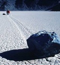
Natalie and I met at the turn off to Lake Como at 4am. We hopped in my car and drove to the TH where we began just before 5am. An earlier start may have been prudent, but I knew that we were basically banking on a day without thunderstorms. Quite the dangerous leap of faith.
One neat thing about this route is that each section creates a different obstacle. This first trick is route finding and gaining the ridge. In my experience, following the tape is a sure way of crossing Tobin Creek and gaining the ridge without too much bushwacking. However, it seems that some of the tape didn't survive the winter and this trip we struggled to follow the tape in the dark in a few sections. We took a chance and just bee-lined for Tobin Creek. We probably crossed too low (about 9,050) and had significant bushwacking. My arms are fairly cut up. The flip side: we saved some valuable time. Pick your poison. Regardless, after you cross the creek you'll make a line for the ridge where it becomes more steep.
Rocks and More Rocks to 12,880
We gained the ridge at about 6:30am (1 hr 30 mins) and felt pretty great. From here, route finding is no longer an issue. We just followed the tape and then kept the ridge. The bummer is that the talus hopping begins well before the trees end. Natalie found her hiking poles to be a pain and stashed them. I was glad not to have them as I could use my hands for a lot of the rock. We gained vert more quickly in this section. The rocks after tree line before point 12,880 are relatively stable and small.
Talus starts before treeline. Here the rock is much larger than from 12k to 13k. The view from Point 12880 of LB standard route. (With people on top) All that haze is from the fires.
Sticking to the Ridge - 12,880 to 13,500
At 9am (4 hrs) we reached Point 12,880 and finally the route came into view. Absolutely spectacular. We noticed three people on top of Little Bear who obviously used the standard route. At this point we were feeling a little fatigued so we took some time to rest and GU up. From here, we followed the ridge closely. Last August we skirted point 12,880 and the few crests beyond that. We may have saved some elevation loss, but we also encountered a lot of loose rock. This time, we stuck to the ridge and enjoyed a significant amount of stable rock, yet this section took us longer than I had planned. We ate and drank a lot and time just ticked away. At least we got a lot of pictures and tried to soak in the stunning views in front of us.
The Climbing Begins
The timeline is a little unclear to me here as perhaps we were a little complacent in pushing our pace. After about 13,300 we donned the helmets and began using our hands a lot more. We mostly kept within 10-20 feet of the ridge, but didn't feel the need to stay right on top of it. Again there is a lot of stable rock and the class 3 moves are pretty basic, but it just goes on and on. The last 500 feet to South Little Bear felt much, much longer.
Taken from about 13500 showing some of the route Class 3 climbing near SLB
South Little Bear
Finally, we reached Little Bear's little twin. The time? 12:30pm! I don't know where all that time went, I really don't. I also don't know where my water went. Or all the food I had carried with me. Normally on a mountain, elevation is my mental mile-marker. At 12,880, I knew we had a little over a 1,000 feet of vert left. That should translate to less than an hour. But there isn't anything normal about this mountain. Sustained class 3+ climbing and an unknown amount of gains/losses if you stick to the ridge really adds up. Natalie and I both consider ourselves solid hikers pace-wise. We're no animals, but we aren't pokey either. And we weren't having off days.
Anyway, we enjoyed the summit, took pictures, waved and hollered at the LB group who was now most of the way across the Blanca traverse. Finally, we set off to the final destination. At this point, I was pumped with adrenaline and feeling less tired. I had waited months to finally get the chance to have a rematch with this traverse.
The "Mama Bear" Traverse
I found the initial 10-15 feet (ish) downclimb from SLB to be fairly solid without too much exposure. We did drop a few rocks and had to listen to them painfully as they dropped...and dropped...and dropped. Creepy. But the moves weren't too hard. So far, so good. We traversed a bit, picked the middle ledge, and again, no problems. This ledge was a little exposed and we did turn in to face the mountain. After another set of ledges, we were more than half way across the traverse within 20 minutes of leaving SLB. Not so bad. Then we reached the dreaded section that cost me a summit last August. I know now that most people cross this small knife edge by stepping slightly to the right. I was considering this option but from our vantage, it seemed that it would be incredibly sketchy and exposed. Natalie suggested we scout out the west (left) side of the mountain a bit further. "There isn't just one right way to do this thing," she said. She was right. After some time spent really looking at options (at this point, we're either getting caught in rain or we aren't, right?) we ended up downclimbing about 20 feet. From there, we easily traversed over to the more normal route and did the bottom half of the downclimb into the hourglass. I had been worried about that part, but it wasn't too bad imo. The rock is solid just where you need it to be. On the other side of the hourglass notch we had just had less than 20 feet to climb back up. We followed the cairns as the climbing got much easier. The next thing I knew, I was within a few feet of the summit. Four trips and it wasn't until that moment when I knew I would make it. The summit was ours just after 1:30pm, a whopping 8.5 hours hours later.
Beginning of the traverse, including initial down climb and ledges Natalie on one of the ledges My tricky part. Most seem to go right, we went left. An extra credit downclimb. The hourglass is down there somewhere. Long awaited success!
Getting Back Down: The Mandatory Part
I did my best to take in the accomplishment on the summit. After putting months of effort into this route and three failed trips, this was my hardest earned summit to date. Further, with this mountain behind me I know I am set to complete all 58 (This was my 35th with a good handful of "hard" ones in the bag). The elation on the mountain only lasted so long before we made ourselves get back up and keep moving. We "only" had 4 miles left to get back to our car but it would take a very long time.
Getting back across the traverse was no problem and took about 40 minutes. From there, we slowed down considerably. We made the decision to drop from the ridge in a few places to avoid the gains/losses and realized why that is unadvisable as the rocks really do get more loose and the climbing gets harder. We ran into a few snowfields around 13,800 - 13,500 which also complicated matters. We decided to also skirt point 13,132 just to see if it was worth it. Again, not advisable and it cost us valuable time/energy. Skirting this point led us into a mine-field of large, loose rocks. Several large boulders tumbled under our feet and slid a ways down the mountain. Natalie fell a few times which could have been dangerous. From there, we learned our lesson and stuck to the ridge over 12,880. We lost some time after tree line looking for Natalie's poles. Why do we keep losing things? We think they are at about 11,100 if there are any good samaritans planning this route soon! Again, lost time. Natalie and I were both digging deep at this point. We were practically out of water and energy. We made it across Tobin Creek just before the sun set and back to the car about 9 pm. In short, it was one long, 16 hour day.
And now for an Oscar moment: I want to thank Jen, my summer 2010 hiking partner who had the fabulous/epically stupid idea to try this thing in the first place and had the brilliant idea of stopping at a hardware store to purchase a certain role of bright orange flagging tape on our way to the mountain the first time. Thanks to Jim (dancesatmoonrise) for the bonus December attempt and for encouragement to keep going. Thanks to Chris (cbauer10) for encouragement and advice in all things hiking. And lastly, Natalie (nkan02) for getting this thing done with me. I hope to enjoy a walk-up with you soon!
Thumbnails for uploaded photos (click to open slideshow):
OMG, I thought 3rd time was a charm for me - wow, you suffered for this line!
You deserved this summit, so bad!! Lynn, I'm so happy for you. Persistence really does pay off.
Thanks for a thoughtful, well documented trip report...
And congratulations on finally getting a beautiful, hard won battle!
Great effort and dedication. That route looks as difficult as it appeared from doing the ”normal” way. Exposed ridges are deceptive (as you likely know :loldue to all the ups/downs involved & route finding. No more jokes about South Little Bear. Is your middle name tenacious?
Thanks for all the congratulations! I feel great about this one so it was really nice to share with you all. and yes, the ridge does look longer than 4 miles, right??
thanks for discussing the sensitive private property issues with the trailhead and getting there. I forgot to include that in my report. It bears repeating - we don't want to mess up the access issues for others.
That's got to be the word for you Lynn. Way to finally achieve success....and to both of you. Having ”been there, done that” I know what you've been through. It's a long ridge with lots of verts and it's not easy climb.
Great report and photos....especially that summit shot. Those smiles tell it all!
You know months later (and now only 4 ”easy” ones to go), this is still my most proud summit! Thanks for the note. It is funny though, a few days before your post I bought a tee-shirt at a random gas station coming home from the Crestones that has a picture of a mountain climber and the lines, ”Tenacity: What you need to overcome your stupendous lack of good judgement.” So fitting!!
We did it!!! I look forward to the next thrilling hike with you. You were amazing! ok, it is time to unload MY camera with YOUR pictures.
Caution: The information contained in this report may not be accurate and should not be the only resource used in preparation for your climb. Failure to have the necessary experience, physical conditioning, supplies or equipment can result in injury or death. 14ers.com and the author(s) of this report provide no warranties, either express or implied, that the information provided is accurate or reliable. By using the information provided, you agree to indemnify and hold harmless 14ers.com and the report author(s) with respect to any claims and demands against them, including any attorney fees and expenses. Please read the 14ers.com Safety and Disclaimer pages for more information.
Please respect private property: 14ers.com supports the rights of private landowners to determine how and by whom their land will be used. In Colorado, it is your responsibility to determine if land is private and to obtain the appropriate permission before entering the property.


")

 All that haze is from the fires.")


 My Desktop Since December (Taken 12/12/10)")
 Talus starts before treeline. Here the rock is much larger than from 12k to 13k.")
 The view from Point 12880 of LB standard route. (With people on top) All that haze is from the fires.")
 Taken from about 13500 showing some of the route")
 Class 3 climbing near SLB")
 Beginning of the traverse, including initial down climb and ledges")
 Natalie on one of the ledges")
 My tricky part. Most seem to go right, we went left.")
 An extra credit downclimb. The hourglass is down there somewhere.")
 Long awaited success!")