Made it a little past the 2WD TH in a Subaru Legacy... parked about 0.3mi from the fork in the road to the main 4WD TH and to the left for Lulu Gulch. Lulu Gulch was a gorgeous hike - the road is switchbacks up... Middle Mountain is easy to see with the swithbacks, but we decided to skip that and go off the switchback road to climb up toward Browns Peak. Somehow, we did not follow the arrow in Photo 6 in the route description - we went farther over to the right - do not do this (see photo attached). It is steep, with lots of loose and unsteady rock (which also happened to be icy). We reached the ridge, realized where we were supposed to be, and followed the route. The traverse between Browns Peak and Huron (where the route meets with the standard route, NW slopes), is also full of unsteady rock (photo below). Pick your lines very carefully and test each rock (I think I was below the route in Photo 13). I did not traverse across the ridge, not sure if that would have been better. These rocks were also very icy and slippery. Amazing views of the backside of Huron though! Didn't see another person until meeting up with the standard route.
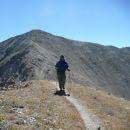
When you meet up with the standard route, it's a nice steep shot up to the summit - took about 20/30 minutes from the trail junction to the summit. There was no snow on any of the route - it was clear. Lots of amazing views of the apostles, La Plata, and more - including the Lulu Gulch route (see photo).
Probably the last few days for some gorgeous aspen colors. The road hike/walk down from the 4WD TH to the 2WD TH isn't too bad. We started a little before 7 and with our detour up Browns Peak and some serious scrambling, it took about 3.5/4 hours to summit... half that on the way down. Gorgeous day - sunny, no wind, not too cold. The clouds and rain started coming in early afternoon, but we avoided it. Keep an eye on the sky though - saw a few people heading up too late for comfort.
|