Download Agreement, Release, and Acknowledgement of Risk:
You (the person requesting this file download) fully understand mountain climbing ("Activity") involves risks and dangers of serious bodily injury, including permanent disability, paralysis, and death ("Risks") and you fully accept and assume all such risks and all responsibility for losses, costs, and damages you incur as a result of your participation in this Activity.
You acknowledge that information in the file you have chosen to download may not be accurate and may contain errors. You agree to assume all risks when using this information and agree to release and discharge 14ers.com, 14ers Inc. and the author(s) of such information (collectively, the "Released Parties").
You hereby discharge the Released Parties from all damages, actions, claims and liabilities of any nature, specifically including, but not limited to, damages, actions, claims and liabilities arising from or related to the negligence of the Released Parties. You further agree to indemnify, hold harmless and defend 14ers.com, 14ers Inc. and each of the other Released Parties from and against any loss, damage, liability and expense, including costs and attorney fees, incurred by 14ers.com, 14ers Inc. or any of the other Released Parties as a result of you using information provided on the 14ers.com or 14ers Inc. websites.
You have read this agreement, fully understand its terms and intend it to be a complete and unconditional release of all liability to the greatest extent allowed by law and agree that if any portion of this agreement is held to be invalid the balance, notwithstanding, shall continue in full force and effect.
By clicking "OK" you agree to these terms. If you DO NOT agree, click "Cancel"...
One of the joys of living in Colorado is a steady, mostly predictable supply of snow during the ski and snowboard "season," during which I ride the lifts and mostly forget about summits, except for occasional trips to NM or AZ. Once the lifts stop and the snow melts, it's time for hiking/climbing above treeline to summits. Winter is for the former, summer for the latter. That's how it works for me, anyway. You might guess, then, that 2011 has been trying my patience. Plans dreamed up back in March for peaks that are usually dry or close to it by early May have come and gone, but the freaking snow hasn't stopped.
Listening to and reading about the weekly exploits of some of the ski mountaineers on this site hasn't made this extended shoulder season any easier. While I work the weekend, do something around town, or hike some low peak, those guys are out in the places where I want to be. Sure, I could grow up a little and simply adapt to what's in front of me, but I'll come out and say it: I don't like hiking on snow or in the cold. Postholing in the trees sucks. Period. Maybe someday, my chatter about getting a splitboard or learning to ski will turn to action, but not yet--not when there are gifts from God like the Spanish Peaks last weekend.
While the eyes of others looked toward Berthoud Pass and Bakerville, my thoughts went southward, toward La Veta. Wednesday, I found this live webcam, which showed me exactly what I wanted to see"the "Breasts of the Earth" looking mighty bare. I think anyone who drives down I-25 past Pueblo has seen these things and wanted to get closer to them. They're spectacular. Right about then, I got an email from Ft. Collins resident ChrisinAZ, who was up for a springtime trip to explore East Spanish Peak and the weekend, indeed, my year, was looking up.
Along the way, we took a detour to the plains to visit Dry Bluff, the unranked, but wild Otero county highpoint.
Since we had ice axes, we brought them along (better safe than sorry) and I put mine to use spearing, then tossing cow pies around.
Here's Chris, with a token hero shot at the summit.
From there, we took a series of back roads across the plains to I-25. As we dodged random cattle and antelope, we soon saw our destination beckoning.
After a quick stop in Walsenburg, the culinary capital of Huerfano County, we hit the road, stocked with Pizza Hut and Subway's finest.
While the Spanish Peaks are visible from hundreds of miles away, the closer you get, the more impressive they become. East Spanish Peak looking dry
We had plenty of time, so we decided to drive around the area, specifically to see if access to class 3 8er Goemmer Butte, pictured below, were possible.
No dice. Private property. No matter. This area is gorgeous, and the vivid green of spring lit up the evening.
Given the scantily clad Spanish Peaks, we were surprised to see that the southern Sangres wore a full blanket of snow.
While I prefer the Wahatoya themselves, the "great dikes" of the Spanish Peaks are a nice piece of eye candy as well. Dike dwarfed by W. Spanish Peak
Finally, we headed out of town on CR360, taking the 4x4 road that forks right just before Wahatoya Camp. This road starts easily, and should not be difficult for any 4wd with high clearance. I read here that a Hyundai Santa Fe can handle the road (h/t Kevin Baker). I think taking anything with less clearance, even a Subaru, would be a challenge. It gets narrow near the top, so I was glad we didn't meet anyone else along the way. Passing could be a chore, as there are few pullouts. Driving the road cuts about four r/t miles and 1600' of gain off the hike from the lower TH.
The road tops out around 9850' with a small parking loop, a TH, and one big fire ring with some flat spots for tents. I had hedged my bets by not bringing a cooler (there's got to be some snow somewhere, right?) and hoping we'd find some firewood. There was firewood aplenty, but a scan of the surrounding area revealed no snow"ironic since we picked this hike to avoid it, but I'd expected enough to chill some beers. Fortunately, Chris came back a minute later with good news"a single patch of snow was about 30 feet from the truck.
We were in business!!!
As twilight faded to darkness, we sat around the fire marveling at our good fortune thus far. Looking up at the stars, sipping on Colorado-brewed Gordon and Modus, talking about peaks we've both done in Arizona and Utah, peaks we look forward to in Colorado and elsewhere, & thinking about our hike of East Spanish was exactly what I've needed for a while. I thought to myself, "This is why I live here."
Contrary to the billboards on I-70, no ski pass from Vail Resorts has anything to do with it.
Honestly, if some act of God had prevented our hiking the next day, I was ok with that, knowing I'd already outdone even the best day spent back in rainy Denver.
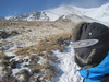
I awoke to 40 degree temps and the urge to get going. We decided to leave snowshoes/crampons in the truck, but took our axes and spikes just in case. About � mile down the trail, we met our first obstacle. It was a gutsy call, not going back to the car for crampons, but we crossed this snowfield safely, getting some use from Chris' axe.
The well-defined Wahatoya trail meanders for two miles, gaining only 400ft or so to the saddle between the peaks. Here are some shots along the way. First peek at our goal
We could see the west ridge and summit ahead.
Suddenly, Chris came to a jarring halt ahead of me, so I asked him why. Here's why:
Someone had installed what looked to be a flimsy trip wire across the trail.
Thankfully, Chris didn't fall, there were no IEDs attached, and the wire was not strung tightly. We cut it down and moved on.
From the saddle, either peak is doable, though the western of the Wahatoya is more of a handful. There are plenty of comfortable campsites available. An old fencepost marks the spot where you enter Las Animas county and head left (east) toward East Spanish.
We stopped for water and looked at W. Spanish just in time to catch the moon as it went into hiding.
From here to treeline, the trail gets faint at times, but there are plenty of cairns to help. After a short descent, the grade steepens to a grunt, and I grunted more than a few times gaining 700ft in 0.4 miles, reaching the ridge a little below treeline.
From there, the trail fades in and out, and was blocked at times by large snowdrifts, but staying close to the ridgeline made the right path obvious. Treeline comes abruptly, with a line of trees resembling a fence, and the talus begins. It starts loose, but is pretty stable overall.
Here are two shots from about 2/3 of the way up to the summit ridge. Looking back at W. Spanish
Up we went, crossing a couple bumps on the summit ridge, then topping out.
Views from the summit are tremendous, with clear shots at neighboring peaks of note: Blanca group, Lindsey, et al 12er Greenhorn Mountain, Pueblo County Highpoint Looking toward Westcliffe, with Mt. Mestas in the foreground Southern Sangres West Spanish Peak
After soaking up the views, snapping lots of pics, and making a halfhearted attempt to dig out the summit register, we made our way back down the talus, through the still-firm snowdrifts on the west ridge, on to the saddle, then back to the TH.
While the summit of East Spanish Peak falls short of the seduction lines of 14k and 13k, this peak has more than enough to recommend it, even after (if?) the snow melts further north. While the higher peaks are mostly where it's at for Colorado hikers, I've found that really prominent mountains, regardless of summit elevation, often feature expansive panoramas unmatched from peaks surrounded by others of similar height A trip here features vast 360 degree views across the Sangres, Wet Mountains, Pikes Peak, east toward the plains, and south to New Mexico and Oklahoma. It offers solitude, great camping, and a chance to diversify your peak list a little. For me, it provided a chance to rekindle the passion for being out in the mountains that brought me to Colorado in the first place. I'm grateful for the chance to have been there, and hope that someone who reads this puts it to good use and checks out the area.
I thought the Pyramid Ski Descent trip report got my heart racing. Man, can't believe you didn't rope up for that snowfield crossing. You young kids are really rocking it in the mtns this spring.
Nice report and great pics. I have been doing long hikes up in North Cheyenne Canyon lately and wondering where else I can do some training hikes as I wait for the Spring (Summer?) thaw. I don't mind doing 14ers in some snow, but come on! I see the Spanish Peaks from Colorado Springs on clear days but have never climbed them. Thanks for the great idea!
Watch out - there's kids that get on this website. But, something's missing ... speaking of ”scantily clad” ... where's the leg shots, my man?!?! 8) Heck, that's the only reason I clicked on this report. Lots of good humor in this report. And, what the h*ll is up with that trip wire ... like we need one more thing to worry about in the backcountry. Next thing you know, wire cutters will be added to the 10 essentials. Very enjoyable, Matt. Nice beer selection. Thanks for posting. Happy trails!
Nice write up, slick. That looks like a great location to hit, especially during shoulder season. I think I need to change my elevation diva ways and accompany you on the next southern colorado journey.
The trip wire has to be another gift from the texan mountaineers or whoever that rogue group is from the lone star state that is taking over our summit registers.
Having done West Spanish Peak twice and enjoying it.....you've driven me to return for East Spanish Peak. Not being a backcountry skier myself, the lure to get above treeline is tugging at me after this long winter.
Thanks to everyone for the comments.
Chris, thanks for helping make this a great trip.
Scot, I thought the lenticular shot you posted was tremendous.
Presto, sorry to disappoint. My legs were visible at the Herzog movie, though the 3D glasses might have distorted things a little...
Pap, I hope you come along for the next 12ers. Bison Peak?
Brian, if I get a splitboard, your exploits will be the driving force.
iluv80s girl, glad to be of service. I'm sure these will be right up your alley.
I can edit double posts, though.
Rick, I made some yellow snow afterward, but no.
Furthermore--Cloud Peak, San Gorgonio, Timpanogos/Nebo are the ultras I'd like to get next.
Loved the post! I have wanted to climb the Spanish Peaks for years as I see them often on my drives south to NM. Is West Spanish Peak much more difficult? It looked like there was more snow on it than the one you went up, any help as I might be inclined to hike it in the next few days as the mountains near Denver are still full of white.
WSP is easier via its standard route from Cordova Pass than either East or West from the saddle. Summitpost provides plenty of info. That route is a half day at its longest. We couldn't see that side of WSP, but a call to the forest service should tell you if the road to the pass is open.
First time I drove south through Colorado I was headed to Arizona for school. That was in '89. I had been to Colorado several times a year from my childhood but never that far south. First time I saw the Spanish Peaks I was reminded of an old girlfriend......
Anyway, 1)very happy you brought the Ice Axe, 2)what's up with the trip wire? That is just plain nasty, 3) I think I'll have a Modus with breakfast this morning. Nice report. I once flew with a flight attendant who didn't know what ”cow pies” or ”buffalo chips” are so she made a P.A. to see a show of hands if anyone on the plane knew..... funny stuff.
Caution: The information contained in this report may not be accurate and should not be the only resource used in preparation for your climb. Failure to have the necessary experience, physical conditioning, supplies or equipment can result in injury or death. 14ers.com and the author(s) of this report provide no warranties, either express or implied, that the information provided is accurate or reliable. By using the information provided, you agree to indemnify and hold harmless 14ers.com and the report author(s) with respect to any claims and demands against them, including any attorney fees and expenses. Please read the 14ers.com Safety and Disclaimer pages for more information.
Please respect private property: 14ers.com supports the rights of private landowners to determine how and by whom their land will be used. In Colorado, it is your responsibility to determine if land is private and to obtain the appropriate permission before entering the property.


")
")
")
")
")
 East Spanish Peak looking dry")
")
")
 Dike dwarfed by W. Spanish Peak")
")
")
")
 First peek at our goal")
")
")
")
")
")
 Looking back at W. Spanish")
")
")
")
 Blanca group, Lindsey, et al")
 12er Greenhorn Mountain, Pueblo County Highpoint")
 Looking toward Westcliffe, with Mt. Mestas in the foreground")
 Southern Sangres")
")
")
 West Spanish Peak")