Download Agreement, Release, and Acknowledgement of Risk:
You (the person requesting this file download) fully understand mountain climbing ("Activity") involves risks and dangers of serious bodily injury, including permanent disability, paralysis, and death ("Risks") and you fully accept and assume all such risks and all responsibility for losses, costs, and damages you incur as a result of your participation in this Activity.
You acknowledge that information in the file you have chosen to download may not be accurate and may contain errors. You agree to assume all risks when using this information and agree to release and discharge 14ers.com, 14ers Inc. and the author(s) of such information (collectively, the "Released Parties").
You hereby discharge the Released Parties from all damages, actions, claims and liabilities of any nature, specifically including, but not limited to, damages, actions, claims and liabilities arising from or related to the negligence of the Released Parties. You further agree to indemnify, hold harmless and defend 14ers.com, 14ers Inc. and each of the other Released Parties from and against any loss, damage, liability and expense, including costs and attorney fees, incurred by 14ers.com, 14ers Inc. or any of the other Released Parties as a result of you using information provided on the 14ers.com or 14ers Inc. websites.
You have read this agreement, fully understand its terms and intend it to be a complete and unconditional release of all liability to the greatest extent allowed by law and agree that if any portion of this agreement is held to be invalid the balance, notwithstanding, shall continue in full force and effect.
By clicking "OK" you agree to these terms. If you DO NOT agree, click "Cancel"...
I had a great time, despite the close-call learning experience (you'll understand soon). These 3 peaks all give great views of surrounding mountains, especially Torreys. Having already climbed the beast 14er peak that dominates the view, it's so nice to get beautiful new aspects of it from nearby 13ers!
13ers: Sniktau, Cupid, Grizzly Peak D
Time: 8 hours, 20 minutes
Distance: 8.0 miles
Elevation Gain: 5,220
My friend Aaron (spong0949), his friend Jordan, and I planned to head up Sniktau and see if we feel like busting up Cupid and possibly even Grizzly, and got a "lazy start" of about 7:40am.
Loveland Pass is an awesome trailhead in spring, and it gets you right to biz with motivating peaks staring at you from the start.
From the TH, you can see Cupid & Grizzly, but not Sniktau. Pics from the TH:
The "hub hump" of Pt 12,915:
12,915 on left, Cupid on right:
Cupid center, Grizzly on right:
On the way from Pt 12,915 to a false summit before Sniktau, Torreys is sure you know she's keeping an eye on you:
Aaron & Jordan getting up the false summit:
After that push, you know how it is when you THINK the summit is RIGHT THERE, yet you get frustrated to find that the actual peak you're headed for is just a bit MORE distance. Sniktau shows itself on the false summit:
Eisenhower Tunnel is visible from this area, reminding us that civilization is missing out on an awesome day in the mountains!
Heading up Sniktau:
Torreys from here, with Grizzly on right:
Grizzly in center, Cupid just to the right and closer:
A closer look at Grizz & Cupid:
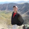
Enjoying the easily-earned summit of Sniktau (me, Aaron):
I didn't write it down, but I believe it was only around 1,700 of Elevation Gain to Sniktau's summit. We all had plenty of energy left, but since Aaron had already done Cupid & Grizzly very recently, he was going to enjoy a nice walk back to his truck and wait for Jordan & me.
So Jordan and I headed back over to Pt 12,915, and decided Cupid looked easy enough, so that's where we were headed.
Before long, we were on Cupid's "summit" (a big round buttcheek). The winds had given us a little trouble, but when you're dressed for it, it's not bad and didn't slow us down much. Here's Jordan on the actual summit of Cupid:
...and then we switched spots so he could have the now-way-closer Torreys (and Grays) as his backdrop:
Looking back to Sniktau from Cupid (it's the last peak on the right):
Alright, Jordan is a beast for making it this far. He had returned to Colorado from almost-sea-level TWO DAYS AGO. Wow. He expressed that he still wanted to be able to walk tomorrow, so he headed back to the truck.
Dumb mistake number one: Deciding to go on without my friends. If something bad should happen, I will want them there!
Having a look over to Grizzly and the 12,936-ft bump that I'll never forget:
Climbing down from Cupid did not seem like anything I'd had to do so far. It was a steep hike down and then over to the bump before Grizz.
View from partway down Cupid:
From the bump-Grizz saddle, looking up at the hardest obstacle of the day:
The wind was just relentless at this point, and all the way up Grizz. It sure kept me moving! It was steeper than I thought it would be, as a pleasant surprise. I love really working for it. Sniktau & Cupid just hadn't satisfied this desire!
Approaching the summit:
Torreys & Grays:
Nearby 13er Lenawee Mtn:
Okay, now I was getting a little tired and ready for the ride home. Oh but wait, there's some more ups & downs (as everyone knows about the return from Grizzly). But the cold winds, my ignored hunger, and desire to not make my buddies wait too much longer for me took too much of my attention on the way back...
Last look up Grizz before the big mistake of the day:
A little idea of the winds:
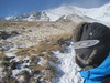
Okay I made it up to the 12,936-ft bump by Grizzly, but totally wasn't watching where I was walking (MISTAKE NUMBER 2, THE BIG ONE) and I walked out towards the cornice much too far. All of a sudden, quiet as a ninja, the ground just caved in and I found myself panicking to grab a hold of something that didn't exist around me. I braced for a fall, but it fortunately never happened... I soon found myself stopped from sinking any further, but I could see deeper into the hole I just formed and didn't want to cause myself to fall farther in!
The hole:
I was down enough where I could reach above "ground" with just my hand, outstretched above me, so my feet were probably 7 feet below the snow I had just been walking on. I froze for a minute trying to think of the best way to get out, then I slllooowwwwlllyyy tried to push and stand a little higher with my feet, but the snow beneath me simply crumbled and it did no good. Then I tried slowly pulling the snow with my hands that hadn't yet fallen in, where I had just been on, and some of it just fell in with me. I tried not to panic.
I decided to try putting more surface area of my body on more snow, so it had more chance to hold, so I lifted my left shin and placed it on some of the precarious snow that had partially fallen in. It held! I pushed up onto that shin slowly and used my hiking poles and forearms to transfer some more weight, and they held too! I was out before I knew it.
WOW. Thank you God!
I got another pic for more perspective, with my heart thumping louder than the wind around me:
I realized I had been on a cornice, without ever realizing that I had just walked right out there. I learned to always, ALWAYS watch where you're going!!!
The rest of the way back up Cupid and to the truck I made ABSOLUTELY SURE to stay on rocks peeking out of the ground, even though my tracks clearly were out a ways on my way here. Tracks mean nothing! I could have fallen there, too! And worse, I could have been in an AVALANCHE. This realization hit me more and more on my way back.
Climbing Cupid from Grizzly's side was way harder! The word "buttcheek" didn't cross my mind this time around. And I probably added difficulty by being super-paranoid and certain to climb on rocks, so I definitely went up very steep stuff. But, peace of mind was WORTH IT. I freaked out any time I had to cross even a patch of snow where I couldn't see some sign of ground beneath.
After writing about this as a forum topic, people also expressed similar experiences on this same spot: http://www.14ers.com/forum/viewtopic.php?f=7&t=29603
If you plan on hiking this in winter/spring, allow this picture to come to mind:
Thumbnails for uploaded photos (click to open slideshow):
I hiked Grizzly this tuesday and I saw that hole. I was wondering what caused that. Good work on getting out. Funny...now their is a packed down trial that skirts just a few feet to the west of the hole.
I saw this hole on my summit run of Grizzly. You are very lucky to not have fallen through the Cornice. That cornice was a nasty one. At least 30 feet across and protruding from the ridge. I took a pic of it from Grizzly. Also, did you see the fracturing line on that cornice?
Those cornices are brutal. I was there in the first week of June, nearly a month later, and they were still huge, although I believe May was a record snowfall month.
Fortunately, this 'trail' seems to give a lot of scrambling options to bypass snow formations.
Glad you made it out!!!
Caution: The information contained in this report may not be accurate and should not be the only resource used in preparation for your climb. Failure to have the necessary experience, physical conditioning, supplies or equipment can result in injury or death. 14ers.com and the author(s) of this report provide no warranties, either express or implied, that the information provided is accurate or reliable. By using the information provided, you agree to indemnify and hold harmless 14ers.com and the report author(s) with respect to any claims and demands against them, including any attorney fees and expenses. Please read the 14ers.com Safety and Disclaimer pages for more information.
Please respect private property: 14ers.com supports the rights of private landowners to determine how and by whom their land will be used. In Colorado, it is your responsibility to determine if land is private and to obtain the appropriate permission before entering the property.


")
")
")
")
")
")
")
")
")
")
")
")
")
")
")
")
")
")
")
")
")
")
")
")
")
")