Download Agreement, Release, and Acknowledgement of Risk:
You (the person requesting this file download) fully understand mountain climbing ("Activity") involves risks and dangers of serious bodily injury, including permanent disability, paralysis, and death ("Risks") and you fully accept and assume all such risks and all responsibility for losses, costs, and damages you incur as a result of your participation in this Activity.
You acknowledge that information in the file you have chosen to download may not be accurate and may contain errors. You agree to assume all risks when using this information and agree to release and discharge 14ers.com, 14ers Inc. and the author(s) of such information (collectively, the "Released Parties").
You hereby discharge the Released Parties from all damages, actions, claims and liabilities of any nature, specifically including, but not limited to, damages, actions, claims and liabilities arising from or related to the negligence of the Released Parties. You further agree to indemnify, hold harmless and defend 14ers.com, 14ers Inc. and each of the other Released Parties from and against any loss, damage, liability and expense, including costs and attorney fees, incurred by 14ers.com, 14ers Inc. or any of the other Released Parties as a result of you using information provided on the 14ers.com or 14ers Inc. websites.
You have read this agreement, fully understand its terms and intend it to be a complete and unconditional release of all liability to the greatest extent allowed by law and agree that if any portion of this agreement is held to be invalid the balance, notwithstanding, shall continue in full force and effect.
By clicking "OK" you agree to these terms. If you DO NOT agree, click "Cancel"...
Gear: pack w/Winter Essentials & Overnight Gear, map & compass Winter Essentials:
winter hiking boots (N Face w/Prima Loft insulation), gaitors (didn't need them), micro-spikes, CAMP Corsa ice axe (didn't need it), trekking poles, Lowe Alpine soft-shell pants, MHW (Mountain Hard Wear) Transition soft-shell jacket w/hood, MHW hard-shell jacket w/hood, Mont-Bell UL (ultra-light) Therma-wrap,
two pairs of OR (Outdoor Research) mittens (shell & insulated pair), BD (Black Diamond) fleece liner gloves, goggles & facemask, balaclava
Overnight Gear: OR Alpine bivy, 15 degree down bag, sleeping pads"closed cell & air, Jetboil, thermos, extra food....did not use any of it, because I ended up day-hiking the Peak
NOTE: The aforementioned gear list is a paid endorsement by: North Face, CAMP, Lowe Alpine, Mountain Hard Wear, Mont-Bell, OR, BD, & Jetboil.
(Well, not really. But, if there's a rep out there reading this, please send me your gear and I'll gladly use it while on my mountain adventures! You could consider it as a Christmas gift. ;) )
Resources Used for Trip Planning: prior experience and knowledge of the trail, NOAA forecast accessed from 14ers.com
Foreword
Every year, the small company I work for closes for the week between Christmas and New Years. So each year, I try to plan something fun to do. Generally, that means going to Ouray to climb in the ice park, but this year Ouray is not in the budget. Instead, I want to hike some peaks this year.
Most of my family is in New England (Vermont), therefore I don't have the holiday obligations, so Christmas Day for me is usually a solo affair.
A "solo affair" has its advantages. This trip is an example of that (i.e., flexibility in what I do).
My first plan was to hike up Barr trail, hang out at camp for a while, and then go to the timberline shelter (A-frame) to stay the night. On Sunday I would go to the summit and then descend back to the TH.
The second plan (thought of as I hiked up the trail) was to summit on Xmas day instead, and then descend to the A-frame (where I would stash my overnight gear on the way up), and spend the night. On Sunday, I would hike down.
The third and final (painful?) plan came about sometime during my ascent from A-frame to the summit, or, it might have been thought of on the summit. I'm not sure when I thought of it, but in the end, I stashed my overnight gear at the A-frame, went to the summit, came back to gather up my overnight gear, and descended all the way back to the TH.
Painful?
By the time I got back down to the TH at 9:30-ish, I was tired. This is the third time I've hiked the Peak up-and-down in a day, via the Barr trail. But it's been 7 or 8 years since I've done it. Today as I write this, I am glad I did it the way I did.
I was sore when I woke up.
But that's a good sore.
However, had I known in advance I would day-hike it, I would have left the ~10 pounds of overnight gear at home!
And, I would have replaced my batteries in my headlamp.
Note: I don't recommend descending from A-frame to the trailhead in the dark with almost dead batteries.
Now to the Highlights...
The week leading up to Christmas, Terry (tmathews) had posted on 14ers about going to Barr camp on Christmas Day. I didn't decide until Xmas Eve that I would go up Barr, and once I did decide I would do that, I didn't know when I would start at the TH.
Terry had posted he would leave at 6am.
As it turned out, I did get to the trail at 6am, but he didn't know I would show up because I never told him. He had already started, but quickly turned around because he forgot his sunglasses. I recognized him in the dark as he descended to get his glasses, so I waited a minute until he got back. From there, we hiked to camp together.
En route, we were treated to the sunrise over the Springs...
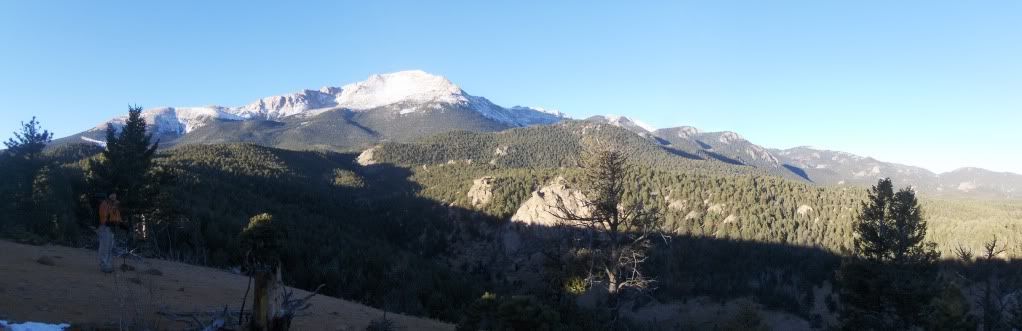
Once at No Name Creek, we hiked up the Experimental Forest trail. I'll often go this way on my way to Barr camp, or on my descent, because it offers a change of views and it mixes the hike up a bit.
The sign says it all...for now.
The Experimental Trail T's up with Longs Ranch road (to the right at the junction) and Bob's road to the left. At the T, we turned left onto Bob's road, where it would take us back to the Barr trail.
Views along Bob's Road...
On our way to camp, Terry had "tested" the weight of my large looking pack when I had taken it off to adjust a layer.
My pack, mostly bulk due to my sleeping pads and bag, looked heavy. He commented his was heavier.
At camp, I "tested" his pack. Holy sh.t! He was right.
Terry basically stocked the pantry of Barr Camp. ;)
It took us about 3hrs to get to camp, arriving around 9am.
Hanging out at camp can be a special occasion, as it was on this day. I met someone (Nikki) who I already "knew," I got to experience hot cocoa with spiced rum (recommended), and the warm fire in winter is always a treat!
There were some comments that I was getting too comfortable in the rocking chair, where I would likely stay for the rest of the day! It was a comforting thought, but, the summit called.
Shortly after 11am, I hauled my pack back on and headed up the trail.
Currently, the trail beyond camp has very little snow, and only a few patches of ice, which is avoidable.
I didn't use my micro-spikes on any part of my ascent.
Bottomless Pit trail turnoff....
I got to the A-frame turn-off at 12:25....
Colorado Springs from A-frame...
I stashed my overnight gear in the A-frame and took a short break before going up. It was almost 1pm when I started up. I figured I would be on the summit by 4pm, where I thought I would wait to watch the sunset.
Leaving A-frame, I was down to my base layers and my liner gloves were off. There was no breeze, it was sunny with mostly clear skies, and probably in the low 40's at 12,000 feet!
And we're now officially in calendar winter?
I don't think the Pikes Peak region is there yet. It felt like fall.
But hey! I'll take it. ;)
Ahead of me were two groups of two, by this time on their descent. Two had left from camp that morning, and the other two from the trailhead. They had the pleasure of "breaking" trail, which with our current snowpack on Pikes, it was probably with little effort. Regardless, their effort made my hike easier!
Just after the 2mi-to-go sign, I took a short side trip to a notch in the NE ridge.
Here's a look to the NW...
Getting back on the trail, I started across the E face, and by this time I had already met the descending parties.
Also by this time, the sun was further to the W and behind the S ridge, shading much of the E face. I stopped near the line where sunlight meets shade, and layered up for the expected cooler temp's I would soon be in.
2pm and I'm about to step into the dark side...
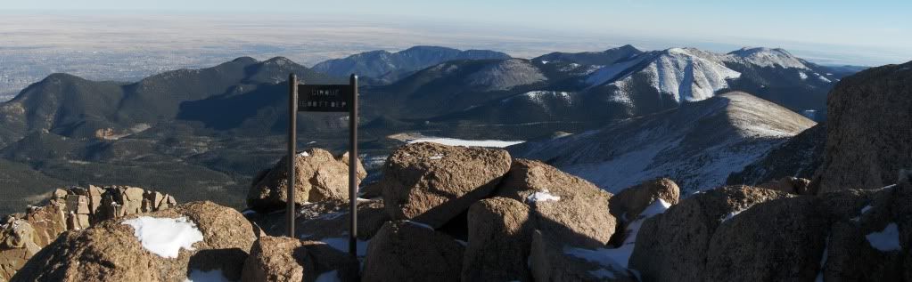
The Sign of the Cirque....
Me and My Shadow near the Summit...
The Aliens have Landed and are Awaiting Me.... Or maybe they're robots?
3:05pm at the tracks without a train in sight....
The winds found me on the summit, albeit a light wind, maybe in the low teens. But it was enough to put a chill in me, so I layered up with everything I had, including face mask.
The sun was still fairly high in the sky to the SW, so I started to have doubts about hanging out for the sunset.
I started doing laps around the summit house and parking area to kill time and to stay warm.
Pan to the W/NW...
Wind Sculptures....
There's a "buzz" in the air....
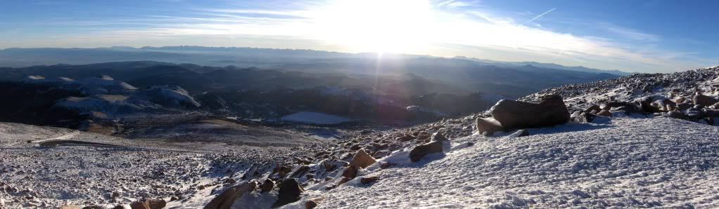
It's 3:50pm, the shadow of Pikes is growing while I'm getting colder....
At this point, I didn't think I could stay around for another 40 minutes to watch the sunset. I did some more laps, trying to stay in the sun for the warmth, but the wind was chilly. Only on the N side of the summit house was I able to get out of the wind, but there I was out of the sun!
Plus, my fingers were getting too cold because I had been taking my mitt off so I had better dexterity to take pictures. I wore my liner gloves, but they didn't provide much warmth while fiddling with the camera.
Oh, a couple more pictures anyway....
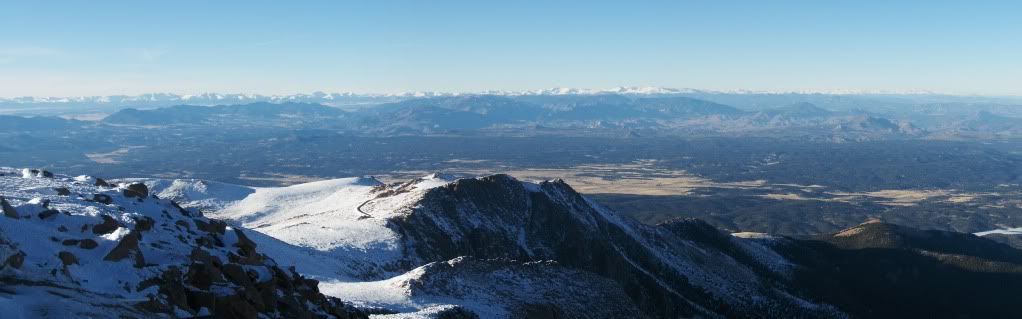
The Sangre de Cristo Range....
It's 4pm, I've been on the summit for almost an hour, and it's time to go.
I decide the sunset can be seen from the east side, at least the shadows it will cast.
The Shadow of Pikes over Colorado Springs and Black Forest....
Sun setting on the south slopes and Almagre Mountain...
As I descended the east slopes, my mind kept going to the thought of sleeping in my bed, versus sleeping in my bag and bivy at 11,900'.
I already realized that it was feasible to descend the whole way, although I would miss out on sleeping in the A-frame with the city lights below, and watching the sunrise in the morning.
I've slept in the A-frame before a few years ago on Christmas Eve; and it felt like a magical experience with the bright lights of Colorado Springs below. On that trip, I woke up to clouds and blowing snow, so I did not see the sunrise.
On this trip, I would experience the city lights as I hiked down Barr, but would forgo the sunrise experience once again. I can live with that, and sleep better (in my bed) knowing there will be other opportunities down the road.
I got to A-frame around 5:30pm, sat down for a short break and had a snack, then packed up. From here, I wore my micro-spikes down the trail since my vision would not be as good in the dark, with a headlamp with weak batteries. Slipping on snow or ice and falling going downhill would probably hurt. So the added traction of the spikes was welcomed.
I stopped at Barr camp to let Neal and Teresa know I was descending the whole way, because I had told them I would stop by on Sunday to let them know I got down safely. They graciously offered me some lasagna, and I mean they really had to twist my arm for this, so I stepped inside for a few minutes and refueled for the rest of my hike down. Dessert was fudge that a day hiker had brought them. Mmmm.....good stuff!
As I came within ~2mi's of the TH, a woman startled me when she said, "And here I thought I had the trail to myself!"
She was standing in the dark, shading her eyes & face as I stopped to talk with her.
As I departed, I asked her if she had a headlamp.
"No, I travel without one. That's why I shaded my eyes from your lamp so I didn't lose my night vision."
And here I am crying about a dim-lit headlamp with dying batteries! Jeez. I'm a sissy.
Thanks for reading, and Happy Holidays!!
Darin
Thumbnails for uploaded photos (click to open slideshow):
I'm a little jealous. I should do this on Xmas next year! By the way I'm a rep for a company that sells male bikinis. We'd love to sponsor your hiking adventures in exchange for using our product. What say you?
Can't believe you hiked that in a day. Ouch! I guess that's one way to milk everything out of a Christmas Day. And what a nice Christmas gift Neal & Theresa gave you with the lasagna dinner and fudge!
Impressive day, Darin! A winter up and down of Barr is tough regardless of the lack of snow. So is that Experimental Forest/Bob's Road route shorter than Barr Trail? I might have to try that variation some day. Glad the aliens didn't beam you up on the summit.
Great hiking with you, Darin! Thanks for showing me where Bob's Road is. I was actually back up at Camp yesterday; I hiked up from Waldo Canyon. Interesting route. Teresa told me that you went back home after the summit and didn't stay up at A-frame. That would have been a cold night!
I'm planning a hike up Pikes in Feb.... but do ~not~ plan on a single day round-trip. (yeah, I'm a wimp).
Q: Is the snow cover you found on the route 'typical' for this time of year? (With all the snow I've read about in CO... I would have thought Pikes would have heavier cover..)
Artvandalay, I think your offer is nice, but you probably put images in peoples' minds that they did not want. ;)
And by the way, are you an architect?
Tripper, the Pikes Peak region has been getting missed in the storms. Hopefully we'll get some soon though! Good luck and have fun with your hike!
Kevin, I don't think it adds much or less distance than Barr.
And, I wasn't the only one that dayhiked it Saturday. I was just the stupid one that carried waaaay too much stuff! I should plan ahead better.
Terry, do you mean you came up from Longs Ranch rd? and parked at Waldo? Nice hiking with you too.
Caution: The information contained in this report may not be accurate and should not be the only resource used in preparation for your climb. Failure to have the necessary experience, physical conditioning, supplies or equipment can result in injury or death. 14ers.com and the author(s) of this report provide no warranties, either express or implied, that the information provided is accurate or reliable. By using the information provided, you agree to indemnify and hold harmless 14ers.com and the report author(s) with respect to any claims and demands against them, including any attorney fees and expenses. Please read the 14ers.com Safety and Disclaimer pages for more information.
Please respect private property: 14ers.com supports the rights of private landowners to determine how and by whom their land will be used. In Colorado, it is your responsibility to determine if land is private and to obtain the appropriate permission before entering the property.


")
")
")
")
")
")
")
")
")
")
")
")
")
")
")
")
")


