Download Agreement, Release, and Acknowledgement of Risk:
You (the person requesting this file download) fully understand mountain climbing ("Activity") involves risks and dangers of serious bodily injury, including permanent disability, paralysis, and death ("Risks") and you fully accept and assume all such risks and all responsibility for losses, costs, and damages you incur as a result of your participation in this Activity.
You acknowledge that information in the file you have chosen to download may not be accurate and may contain errors. You agree to assume all risks when using this information and agree to release and discharge 14ers.com, 14ers Inc. and the author(s) of such information (collectively, the "Released Parties").
You hereby discharge the Released Parties from all damages, actions, claims and liabilities of any nature, specifically including, but not limited to, damages, actions, claims and liabilities arising from or related to the negligence of the Released Parties. You further agree to indemnify, hold harmless and defend 14ers.com, 14ers Inc. and each of the other Released Parties from and against any loss, damage, liability and expense, including costs and attorney fees, incurred by 14ers.com, 14ers Inc. or any of the other Released Parties as a result of you using information provided on the 14ers.com or 14ers Inc. websites.
You have read this agreement, fully understand its terms and intend it to be a complete and unconditional release of all liability to the greatest extent allowed by law and agree that if any portion of this agreement is held to be invalid the balance, notwithstanding, shall continue in full force and effect.
By clicking "OK" you agree to these terms. If you DO NOT agree, click "Cancel"...
October 5, 2010
~2.1 Miles, ~1,700 Gain.
Trailhead: End of the road in Hurricane Basin. 4WD.
Although 13,688 is not technically Wetterhorn's neighbor, I used this peak as a warm up the day prior and probably does not warrant a trip report itself so I combined it with this report.
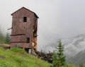
My wife and I made the drive to Lake City and thoroughly enjoyed the lack of people on the Engineer Pass road. A few miles short of the summit of Engineer Pass, we turned off at the Schafer Gulch road and drove our way up into Hurricane Basin. The road was fairly rocky and slow going in some areas but we made it and I parked next to an old mining building at ~12,500. I had orphaned this peak last week and was itchin' to get it climbed. Considering the condition of the peak last week, I am glad that I left the peak to be climbed on this separate occasion.
Upper Hurricane Basin.
From my parking spot, I hiked southeast higher in Hurricane basin and started climbing up a talus slope toward the 13,688-Wood saddle proper. This is not the correct route. I climbed to the 13,688-Wood saddle and was confronted with a short headwall. I climbed up the 15 foot headwall which was extremely crappy 4th class rock, and was greeted by a very narrow, extremely exposed ridge. If the rock quality was any good, I am sure it would have been a blast but the rock quality was everything but stellar. I down-climbed, very carefully, back down the headwall and back down the gully into the basin.
The nasty class 4 headwall. The wrong way.
The ridge traverse to Woods. Yuk.
Looking down the class 4 headwall.
The correct gully to the ridge was the 3rd gully to north of the gully that leads to the 13,688-Wood saddle. The 2nd gully was obvious that it didn't go. When I was in the correct gully to the ridge, the climbing was mostly class 2 with maybe a few moves of class 3. Once on the ridge, it was an enjoyable hike to the summit. From the summit, nearby peaks were getting smashed by some snow squalls and the skies were overcast.
The correct gully.
Looking down the correct gully.
South ridge to 13,688.
Snow squalls from the summit.
For something different, I descended the north ridge of 13,688 toward Gravel Mountain. There was an old trail that I followed until I could make a direct descent to my car. The descent was on lose talus all the way back into the basin. I arrived back at my car and drove down the basin where I caught up with my wife who hiked down the basin and from there, we made our way to our campsite at the base of the 4WD road at Matterhorn Creek. If I were to climb this peak again, I would climb the broad west slopes of Gravel and make the short traverse to 13,688. Much less talus and easier route finding.
Looking back at 13,688 from Gravel.
13,688 from Hurricane Basin.
Point 12,975
Point 13,201
Point 13,300
Broken Hill 13,256
October 6, 2010
~11.2 Miles, ~5,000 Gain.
Starting Trailhead: End of road 870. Ending Trailhead: Matterhorn Creek TH, same TH for Wetterhorn.
I set the alarm for 5:30 AM and I was greeted with rain, so I went back to sleep and woke up again at 6:45 AM. At least the rain had stopped but the skies were overcast. Despite the weather, I decided to give my climb a try. My wife dropped me off at the end of the road (870) where I was quickly greeted by a gate, some nasty signage and a for sale sign. Being a good citizen, I proceeded directly up the hill to avoid the private property. Continuing upward, I finally hiked out of treeline and headed for the 12,599-12,975 saddle. The weather wasn't improving.
By the time I reached the 12,599-12,975 saddle, I was completely engulfed in clouds. I hiked up the mellow south slopes of 12,975 and arrived on the summit at 8:45 AM with solid views of white. From the summit of 12,975, I carefully navigated my way toward Point 13,129 and not very long after descending off of 12,975, I encountered an interesting section of ridge. To avoid some towers, I dropped about 100 feet below the ridge on the northwest side and hiked northeast towards 13,129. Once on top of 13,129 the weather cleared for a moment and I made the short easy traverse over to the summit of 13,201 arriving at 9:45 AM.
Easy south ridge to 12,975.
Ridge during a clearing somewhere along the 12,975 - 13,201 traverse.
13,201 from 13,129.
Break in weather.
My route up 13,201 from 13,129.
Again, the weather had moved in and my views were a bit limited. My descent off of 13,201 was the most frustrating part of the day. Just below the summit was a short cliff band that couldn't be easily down-climbed. I headed south from the summit until I could find a weakness in this cliff band, and once I found an easy area to down-climb I headed back to the north ridge. The fog made things exciting as I kept getting cliffed out by large cliffs which didn't allow access to the 13,201-13,300 saddle.
13,129 from 13,201.
Cliffs on the north ridge during a clearing. From the bottom, after my traverse.
I ended up climbing back up the base of the summit cliff band an worked my way down the south ridge until I could find a way toward Mary Alice Creek. Eventually, I found a route downwards and once below the cliffs I traversed north on some talus to the 13,201-13,300 saddle. Once I reached the saddle, I found a gully that would have given me better access to the saddle but it certainly wasn't obvious from the top down, especially when the route was engulfed in clouds.
North face of 13,201. I think the gully on the right would go with a traverse below the initial summit cliff band.
The weather was clearing again, and 13,300 appeared to be an easy hike from the saddle. I hiked up the easy south slopes to the summit arriving at 11:15 AM and again, was completely engulfed in clouds. I spent a few moments roaming the flat summit to make sure I found the high spot. After a short break I headed down the east ridge of 13,300 to the 13,300-Wetterhorn saddle.
Easy slopes up 13,300.
Neat Spires on my descent off of 13,300.
East ridge of 13,300.
Wetterhorn during a clearing.
From the 13,300-Wetterhorn saddle, I traversed toward Point 13,117 where I met up with the Wetterhorn trail. It was nice to have a trail as I followed the trail down to ~ 12,500. I broke off the trail and headed toward the Matterhorn-Broken Hill saddle and from the saddle, Broken Hill was an easy climb. When I reached Point 13,052 on my way toward Broken Hill, the weather finally started to clear out. At last I made the summit of Broken Hill at 1:00 PM and finally had some decent views of Uncompahgre and Wetterhorn.
Coxcomb. No snow, wtf?
13,300 from my traverse around Wetterhorn.
Broken Hill.
Uncompahgre during a clearing.
Wetterhorn and Matterhorn from Broken Hill.
Uncompahgre from the summit of Broken Hill.
After absorbing the views, I headed back to the Broken Hill-13,052 saddle and then west directly down towards Matterhorn Creek. The descent was steep and I arrived back at my car at Matterhorn Creek Trailhead at 3:30 PM.
Neat waterfall on the descent from Broken Hill.
Route Maps.
Thumbnails for uploaded photos (click to open slideshow):
I went up the east ridge of 13300 descending from Wetterhorn at the Fall Gathering and got pics of those same giant hoodoos (albeit in better weather). Cresting the top and catching that view of Coxcomb almost took my breath away - astounding!
I'm surprised you didn't make the short out-and-back to 12983 (although given conditions, maybe you didn't even see it?) It was one of the more interesting points I saw in the area - the topo doesn't really give you a feel for the drama of the north face). The cairn on the summit must be six or seven feet tall since I could see it clear as day from 13300.
Those are some seriously cool pics of Coxcomb, Uncompahgre, Wetterhorn, and Matterhorn under some exciting but harmless weather. This a great time of the year to be in the mountains, and your report really conveys that.
Its' been a few years since I did these. I found the descent off 13201(Mary Alice Peak) (coming up from Mary Alice Ck., using old trails to get to timberline)to the NW, easy walking NE to the 12500+ saddle, then up 13300. In respect to the wonderland of pinnacles and volcanic forms, the peak is most appropriately named Mary Jane Peak, also of course in deference to the new industry of medical marijuana. This hike in the fall is highly recommended as you can see from the pictures that have sunlight.
Caution: The information contained in this report may not be accurate and should not be the only resource used in preparation for your climb. Failure to have the necessary experience, physical conditioning, supplies or equipment can result in injury or death. 14ers.com and the author(s) of this report provide no warranties, either express or implied, that the information provided is accurate or reliable. By using the information provided, you agree to indemnify and hold harmless 14ers.com and the report author(s) with respect to any claims and demands against them, including any attorney fees and expenses. Please read the 14ers.com Safety and Disclaimer pages for more information.
Please respect private property: 14ers.com supports the rights of private landowners to determine how and by whom their land will be used. In Colorado, it is your responsibility to determine if land is private and to obtain the appropriate permission before entering the property.


")
")
")
")
")
")
")
")
")
")
")
")
")
")
")
")
")
")
")
")
")
")
")
")
")
")
")
")
")
")