Download Agreement, Release, and Acknowledgement of Risk:
You (the person requesting this file download) fully understand mountain climbing ("Activity") involves risks and dangers of serious bodily injury, including permanent disability, paralysis, and death ("Risks") and you fully accept and assume all such risks and all responsibility for losses, costs, and damages you incur as a result of your participation in this Activity.
You acknowledge that information in the file you have chosen to download may not be accurate and may contain errors. You agree to assume all risks when using this information and agree to release and discharge 14ers.com, 14ers Inc. and the author(s) of such information (collectively, the "Released Parties").
You hereby discharge the Released Parties from all damages, actions, claims and liabilities of any nature, specifically including, but not limited to, damages, actions, claims and liabilities arising from or related to the negligence of the Released Parties. You further agree to indemnify, hold harmless and defend 14ers.com, 14ers Inc. and each of the other Released Parties from and against any loss, damage, liability and expense, including costs and attorney fees, incurred by 14ers.com, 14ers Inc. or any of the other Released Parties as a result of you using information provided on the 14ers.com or 14ers Inc. websites.
You have read this agreement, fully understand its terms and intend it to be a complete and unconditional release of all liability to the greatest extent allowed by law and agree that if any portion of this agreement is held to be invalid the balance, notwithstanding, shall continue in full force and effect.
By clicking "OK" you agree to these terms. If you DO NOT agree, click "Cancel"...
Let's start with the basics: Started on trail: 6:35AM
One 20 minute break @ 11,400'
One 10 minute break @ 12,500' Summited: 10:35AM
Lunch 1:10 minutes Headed down at 11:45AM Back at trailhead 3:20PM
Up in 4:00 hours (or 4:20 for the rest of my group). Down in 3:35 hours (we stopped for many photos since the fall colors were spectacular). Total time: 8:45 hours.
GPS (two separate units) averaged:8.4 miles RT.
Elevation gain: approximately 4,100'.
Weather: Sunny, cloudless, fairly light winds...perfect.
34 degrees @ the start and 70 degrees @ the car after the hike.
Hikers: Downhill Bri (me), the Uphill Queen (wife), Minnesota Di and Minnesota Doug (adventurous friends).
We stayed in Twin Lakes at a very nice cabin called the Treehouse:
open main level, three bedrooms and a terrific wraparound deck with views of Twin Lakes and Mt. Elbert. We found it at www.VRBO.com/311743.
It was very convenient with a 1.2 mile paved road drive (10 minutes) to the lower trailhead (South TH).
Add 1.8 mile drive (an additional 20 minutes) on a bouncy 4WD road (very doable with any moderately high clearance vehicles)
to the upper trailhead parking area where we parked.
(There is a lower TH parking lot if you want to add extra miles to your hike...but why would you want to???)
The sun had not yet risen when we crossed the bridge onto the Colorado Trail and began the hike. The trail is well defined and well marked where the Mt. Elbert
route branches off.
The well marked trail
We made a bet as to when the sun would peek over the eastern mountains and Diane won with a guess of 7:10. (She had to "buy" beers back at the car.)
The sun filtered through the trees making the trail quite tranquil.
The morning trail
The trail rose sharply through the aspens and pines where we caught up with a lone hiker named Steve (from Kansas) who was reconquering the peak. He was
the only other person we encountered on this route during our uphill climb. As we gained elevation, the trees thinned and the sun warmed the morning air.
The Uphill Queen & Minnesota Di nearing the treeline
We took a light "snack" break around 11,400' near the treeline.
First break at 11,400' with Elbert looming above
Beyond the trees we were afforded great views of Twin Lakes and the colorful fall aspens behind us. The trail was hardpacked, wide and comfortable.
After another break at a huge rock around 12,500', I found my step/breath rythym and told my companions I was going to forge ahead.
Step-inhale, step-exhale, step-inhale, step-exhale, repeat, repeat, repeat.
The trail up was a steady rise to a longer "flat" section where trail turned southeast where someone thoughtfully used stones to outline
and spell out " 14,000' " across the trail.
I knew I was close...well, sort of...probably about .7 miles and 400+' to go. A series of long switch backs headed to the summit.
No scree, no talus, no false summits. The trail intersects the standard route trail and was a short 100 yards to the peak.
I was the first to the summit at 10:35 and enjoyed the quiet and views in solitude. I relaxed until my trailmates arrived.
The "slow pokes" arrive at the summit
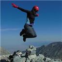
We enjoyed a celebration of achieving the summit of the highest point in Colorado, the second highest in the lower 48 states. SWEET!
We ate lunch and smiled for the camera.
Minnesota Di & Minnesota DougThe Uphill Queen and Downhill Bri (me)Group shot at the summit
We signed the log and watched as small groups of hikers reached the top.
10 to 12 people who made the trek up the Standard/Northeast Ridge Route summited as we were finishing lunch;
one woman celebrated her 50th birthday on the top with her friends. When we began our descent, Steve of Kansas arrived.
Going down was wonderful because we had the lakes and yellow aspens in view all the way down.
The way down to Twin LakesThe afternoon's fall colors
We met one group of three and a second of two heading up.
It seems the South Route/East Ridge had far fewer hikers and was shorter with a bit less elevation.
The overall gain for both routes is about 1,000' per mile.
The photo opportunites kept popping up all the way down.
Best Friends ForeverKnuckle-bump buddies
When we entered the trees, the aspens glowed like golden sunlight against a deep blue sky.
The down trail through the treesSunlit aspens and blue sky
Minnesota Di paid off her winning bet back at the upper TH with ice cold beers from the cooler.
A silly beer
Trip Summary: This was our 10th 14er and Doug & Di's 2nd.
Is is our favorite hike. We all enjoyed the well defined trail, the ease of hiking on a hardpacked path, the longer distance,
no false summits, the "healthy" elevation gain and the lack of crowds on our route. _______________________________________________________________________________________________________________________________
I apologize for not posting this report sooner but after our return, our sweet, beloved dog, Chelsea (the Hiking Pup) passed
away on 9/23/10.
"The Hiking Pup" on the trailChelsea was happy in the mountains
She was a Golden Retriever who, at 15 years, 2 months, was too old to hike any more.
Her spirit is now hiking the trails of Colorado she loved so much.
May she rest in peace and love
Thumbnails for uploaded photos (click to open slideshow):
Great pictures! I did this route yesterday and it was still gorgeous, but one of the hillsides was already wiped of color. I ended up going over to S. Elbert and then couldn't find a great route to go down, but eventually made it back to the trail. So sorry to hear about your hiking pup, she looks like a sweetie.
Caution: The information contained in this report may not be accurate and should not be the only resource used in preparation for your climb. Failure to have the necessary experience, physical conditioning, supplies or equipment can result in injury or death. 14ers.com and the author(s) of this report provide no warranties, either express or implied, that the information provided is accurate or reliable. By using the information provided, you agree to indemnify and hold harmless 14ers.com and the report author(s) with respect to any claims and demands against them, including any attorney fees and expenses. Please read the 14ers.com Safety and Disclaimer pages for more information.
Please respect private property: 14ers.com supports the rights of private landowners to determine how and by whom their land will be used. In Colorado, it is your responsibility to determine if land is private and to obtain the appropriate permission before entering the property.


")


 The well marked trail")
 The morning trail")
 The Uphill Queen & Minnesota Di nearing the treeline")
 First break at 11,400' with Elbert looming above")
 The \"slow pokes\" arrive at the summit")
 Minnesota Di & Minnesota Doug")
 The Uphill Queen and Downhill Bri (me)")
 Group shot at the summit")
 The way down to Twin Lakes")
 The afternoon's fall colors")
 Best Friends Forever")
 Knuckle-bump buddies")
 The down trail through the trees")
 Sunlit aspens and blue sky")
 A silly beer")
 \"The Hiking Pup\" on the trail")
 Chelsea was happy in the mountains")
 May she rest in peace and love")