| Peak(s): |
Uncompahgre Peak - 14,318 feet Wetterhorn Peak - 14,021 feet Mt. Sneffels - 14,155 feet |
| Date Posted: | 08/14/2010 |
| Modified: | 08/15/2010 |
| Date Climbed: | 08/01/2010 |
| Author: | Vinegaroon |
| Peak(s): |
Uncompahgre Peak - 14,318 feet Wetterhorn Peak - 14,021 feet Mt. Sneffels - 14,155 feet |
| Date Posted: | 08/14/2010 |
| Modified: | 08/15/2010 |
| Date Climbed: | 08/01/2010 |
| Author: | Vinegaroon |
| My First 14er Trip - San Juan Range (Part One) |
|---|
|
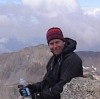
I have been hiking and peak bagging in Southern New Mexico, Arizona and West Texas for a long time, but just recently was bitten by the 14er bug. I did some reading, bought some guide books, and did most of my research right here at 14ers.com. I decided to take a week and do a few in the San Juan Range because I was hoping to avoid the crowds - and I did. I ended up bagging 6 14ers, and I will comment on all the peaks climbed in this report... I drove into Lake City, CO on evening of July 31. I setup camp at Elkhorn Campground in Lake City. I was initially going to camp at trailheads during this trip, but I convinced my family to join me for the last half of the week by staying at a campground with hot showers, BBQ grills and free WI-FI... ;-) In hindsight, I really enjoyed this campground, and the facilities were nice, the camp was clean, and the owners (Floyd and Janet) are VERY nice! I would recommend Elkhorn Campground to anyone who was going to camp in the Lake City area and wanted some creature comforts... Great place for RVs and camper trailers, but also a pretty cool place for tent camping. August 1, 2010 - Uncompahgre Peak: Got up at about 0500 and drove to the Uncompahgre Nellie Creek trailhead. This was my first time in the area, so I tried to do my research and understand where I was going before heading out. I have 4x4 Dodge Ram with a 6-inch lift and BFG AT tires, which do well in the desert mountains, and I was pretty confident I would be able to get to the upper trailheads on the climbs I had planned. I made it up to the Uncompaghre trailhead in short order, over a couple streams and found a couple 4x4s trucks already there. If I recall correctly, I started hiking about 0630 or so. It was a cool morning with light rain/mist. I ate breakfast and checked my gear, etc. before I took off...  In hindsight, this was one of my favorite hikes. I saw more wildlife on this climb than any other...  Mother and two baby foxes were out and about...  This was my first experience with marmots and I had a good laugh observing them. At one point two of them came running right at me on the trail. Glad I had my camera ready...  Having climbed a lot of class 3 and some 4 in New Mexico and Arizona I was anxious to see how those climbs ranked compared to Colorado. Uncompahgre is rated as a class 2 and it was a nice hike for me... No issues with terrain or difficulty EXCEPT I had only been at altitude for about 10 hours and I could really feel the difference. I ski yearly in Colorado, but this seemed much harder on my system... As a side note here - I had no problems with altitude sickness during my trip, and felt stronger every climb (until the last day, details below)... The trail was well marked and easy to follow. Very little to no route finding skills needed here... Met some cool folks on the summit who clicked this victory shot of me on my first 14er!  August 2, 2010 - Wetterhorn Peak: I met some folks who thought that Uncompahgre and especially Wetterhorn seemed like an unlikely introduction to Colorado 14ers, but not having climbed 14ers does not mean you have not done a bunch of high exposure scrambling. Having read most route descriptions, I am pretty sure that I can do them all, so why not have some fun on my first trip? Wetterhorn was the most challenging climb if my trip, and it rained almost the whole day. I do not remember much about the drive to the Matterhorn Creek trailhead. I do remember thinking that North Henson Creek Road would be especially hard on a vehicle without high clearance, but might be attempted with a 2x4 pickup or SUV when dry. But today it was very wet... The hike to the "V Notch" was peaceful and beautiful, yet much of the ridge and summit were unseen because of the low clouds and rain. I saw only 2 other groups out there that day, and they were well in front of me. The shot below was really the best view I had of Wetterhorn all day. The summit made a brief appearance and I tried my best to get a good shot.  I enjoyed the upper basin where there are a bunch of boulders you weave in between in route to the saddle/ridge, as this location is where a bunch of marmots and pikas live. One pika in particular squealed and squeaked warning his friends of my approach. Yet, he let me get within a few feet, and posed for a picture...  Below is what I could see of the rest of the climb from the ridge. I believe that is the Ship's Prow on the left, and the Summit is still in the clouds... As a first-timer I was/am unsure about exactly what I was seeing when I was climbing, and what was still unseen, until I was very close. Visibility was tough the higher I got.  and Ridgeline from Wetterhorn Ridge...") Here I am at the "V Notch", ready to push toward the summit in the clouds...  Below is a shot of the Prow from above the second notch (on the slab) near the final pitch. This was really taken on my descent, and there was a brief clearing of the clouds below...  Here I am on the summit (below). Alone. In the rain. The hardest rain actually came on the summit, and it made me slightly nervous. I knew I needed to get off fast, and that the scramble below was getting slicker by the minute. I snapped a quick summit shot and turned around. I wish I would have had some views on this climb, but it was not meant to be. At least there wasn't any electricity in the clouds while I was up top, although I did hear some thunder as I approached treeline on my descent.  August 4, 2010 - Mount Sneffels: I took a rest day on August 3 (it was another rainy day) and did some geocaching and sight-seeing in the lake city area. I took some cool photos of North Clear Creek Falls and Brown Lake Falls, and explored some other wonderful places nearby. On the 4th I decided to knock out Mt. Sneffels before my family joined me in Lake City. I talked to Floyd (owner) at Elkhorn Campground and he recommended that I drive north on 149 up to 50 west to Montrose and down to Ouray on the 550... I asked him about taking Engineer Pass or Cinnamon Pass, and he advised against it. He said that it would take me about the same time (3 hours or so), although it is a fraction of the mileage. After looking at my maps, and now having been as far as Matterhorn Creek on my way to Engineer Pass, I decided to allow for some extra time and 4x4 it through the mountains. I actually took County 30 out of Lake City, past the trailheads for Handies (Grizzly Gultch and American Basin) and the trailhead for Redcloud and Sunshine (Silver Creek), over Cinnamon Pass and on to Silverton. It took me only 1 hour to reach Cinnamon Pass and just another 40 minutes to reach the town of Silverton. I was humping pretty good, in light rain, in the dark, on some pretty dicey shelf road at times, but there was no one else out there. As a side-note: I think it is actually safer to travel these jeep trails in the dark, given that they are used a lot by ATVs during the daylight hours, and because if there is someone coming at you, you will see their lights around a corner before you see them - which is not true during the day. Be careful of wildlife. I saw quite a few deer on this road at night... Anyway, I picked up the county road to Yankee Boy Basin south of Ouray. The rain stopped and the sky cleared, but the road was a bit muddy with potholes full of water. Most vehicles could have made it to the lower trailhead, but aggressive tires would certainly help. I took my Ram all the way to the upper trailhead, and although the sign recommends a short wheel base (and my quad-cab is not even close), I correctly assumed that I would have the clearance if not the turning radius. There was one or two times I had to back up just a bit and realign in order to navigate the hairpin 4x4 switchbacks to the top. And there was only one small section of mini cliff-bands in the road that challenged my clearance. With the right clearance and driving skills, the upper trailhead is attainable without incident with a regular or longer wheelbase 4x4. Go for it!  Below is a shot of the ridge between Blue Lakes and Yankee Boy Basin...  The climb on Sneffels, after following the easy to navigate trail through Yankee Boy Basin is basically a talus trek... The huge gully is eroding from traffic, so if you choose, you can pick your way through the loose sand and scree. Alternately, you can choose a route on larger rocks and talus. Either way, the gully is wide, but steep, and the obvious route to the Lavender Col (saddle). Below is a shot of the sharp Sneffels ridgeline from the main gully...  The smaller gully is also well traveled, and the left side presents some obvious, and eroding routes. I traversed a bit as I traveled up this gully because there was some traffic above me and a few rocks were being kicked loose. Be careful here because of the "bowling alley" effect when there are climbers above you. I talked to a guy on his decent that commented that a rock almost hit his dog in the head on the way up. Of course, I left my helmet in the truck ;-)  I popped through the notch on the left, just shy of the top of the small gully and quickly gained the summit. The traffic that I encountered in the small gully was coming down, so I found myself alone at the summit... Well, not really alone...  I was rewarded with relatively clear skies and awesome views. Blue Lakes look very cool from the summit. If my family was not in route to Lake City, I would have hiked over on the Blue Lakes Trail, since the climb up Sneffels was a short one from the upper trailhead. But alas, I had to get going back to camp.  I wanted to grab a nice shot of Sneffels from the north, as I took the "car route" on the way back to Lake City, but the sky clouded up and a huge rainstorm hit with hail and lightning on my way out of Ouray. I had a nice lunch in Ouray though, and some ice cream. What a nice little town! Love it! This is Part One of "My First 14er Trip - San Juan Range" for Part Two - the Trip Report for Handies, Redcloud and Sunshine click here... Thumbnails for uploaded photos (click to open slideshow):  Mama Fox on Uncompahgre Peak...")
 My Only Clear View of Wetterhorn Peak All Day...")
 Pika On the Rocks - Wetterhorn Peak...")
 Baby Fox #1")
 Prow (left) and Ridgeline from Wetterhorn Ridge...")
 Marmots Stampede on Uncompahgre...")
 Morning at the UncompahgreTrailhead...")
 Victory at 14,309 Feet - Uncompahgre Summit...")
 Vinegaroon @ The Notch...")
 The Ship's Prow from Above...")
 Wetterhorn Peak Summit Mugshot...")
 Ram - Alone @ Upper Trailhead - Mt. Sneffels...")
 Smaller Gully on Sneffels...")
 Blue Lakes Trail in Yankee Boy Basin...")
 Sneffels Ridge...")
 Marmot Enjoying the View...")
 Blue Lakes from Sneffels Summit...")
|
| Comments or Questions | |||||||||||||||||||||
|---|---|---|---|---|---|---|---|---|---|---|---|---|---|---|---|---|---|---|---|---|---|
|
Caution: The information contained in this report may not be accurate and should not be the only resource used in preparation for your climb. Failure to have the necessary experience, physical conditioning, supplies or equipment can result in injury or death. 14ers.com and the author(s) of this report provide no warranties, either express or implied, that the information provided is accurate or reliable. By using the information provided, you agree to indemnify and hold harmless 14ers.com and the report author(s) with respect to any claims and demands against them, including any attorney fees and expenses. Please read the 14ers.com Safety and Disclaimer pages for more information.