Download Agreement, Release, and Acknowledgement of Risk:
You (the person requesting this file download) fully understand mountain climbing ("Activity") involves risks and dangers of serious bodily injury, including permanent disability, paralysis, and death ("Risks") and you fully accept and assume all such risks and all responsibility for losses, costs, and damages you incur as a result of your participation in this Activity.
You acknowledge that information in the file you have chosen to download may not be accurate and may contain errors. You agree to assume all risks when using this information and agree to release and discharge 14ers.com, 14ers Inc. and the author(s) of such information (collectively, the "Released Parties").
You hereby discharge the Released Parties from all damages, actions, claims and liabilities of any nature, specifically including, but not limited to, damages, actions, claims and liabilities arising from or related to the negligence of the Released Parties. You further agree to indemnify, hold harmless and defend 14ers.com, 14ers Inc. and each of the other Released Parties from and against any loss, damage, liability and expense, including costs and attorney fees, incurred by 14ers.com, 14ers Inc. or any of the other Released Parties as a result of you using information provided on the 14ers.com or 14ers Inc. websites.
You have read this agreement, fully understand its terms and intend it to be a complete and unconditional release of all liability to the greatest extent allowed by law and agree that if any portion of this agreement is held to be invalid the balance, notwithstanding, shall continue in full force and effect.
By clicking "OK" you agree to these terms. If you DO NOT agree, click "Cancel"...
Elbert Southeast Ridge
Left Trailhead: 5:40 AM
South Elbert Summit: 9:15-9:20
Elbert Summit: 10:25-10:50
Arrive at Trailhead: 12:45
Mileage: 11 miles
Elevation Gain: 5300 feet
I missed my first chance to climb this summer last week, so when the weekend looked like it would be stormy and snowy, I wanted to get up above timberline and on a summit on Friday before the ugliness. The Southeast Ridge of Elbert looked like a good first climb, so I set out at 3:20 from Denver and arrived at the trailhead at 5:30.
I have always believed that no matter how hard you train for the summer climbing season, the first peak you summit will push you more than expected. Running the streets of Denver gets me in shape, but different muscle groups or muscle usage or the first time at altitude in a year makes the first one harder than it should be. That would be the theme of the day. The first 3.5 miles of the hike gains 3700 feet, followed by a ridge that's mostly up and down with no real "walls" to contend with. The real work is getting to the ridge, and it felt straight up.
I know nobody likes a math geek, but when I got home, I did some math to figure the average feet gain per mile on all the 14er standard climbs so I had something to compare to. This got me a really misleading number because it doesn't take into account the distance of the climb. Quandry and Huron both gain more elevation per mile than Longs, because they're short climbs, even though Longs gains more elevation and is longer. Still, I did find that most standard climbs gain between 400-600 feet per mile on average. From trailhead to the ridge, this Elbert route gains 1057 feet per mile. Maybe it wasn't my imagination- maybe it really was straight up.
Along the way:
early morning on the path
rising into the basin
further up into the basin
first view of La Plata
The trail is pretty easy to follow- the second river crossing got confusing and I had to bushwhack some willows, but it was clear where the route was taking me, and easy to find. Steep into the basin, then it let up a bit, but after the sharp right turn up the ridge, the elevation gain seemed pretty relentless. Much of it was steep and smooth enough that I had to step only with my toes, with no place for my heels to set. Sure enough, my calves are still soar two days later.
Finally I made the ridge, and after a quick snack, started to really enjoy the views. La Plata is breathtaking from this side. There was a really chilly breeze, but South Elbert kept getting closer and closer, so I felt good. I love the moment of a hike when you simultaneously pull out suntan lotion, winter hat, and gloves, and use them all at once. I reached South Elbert at about 9:15, but with Elbert beckoning, I didn't stay long.
on the ridge
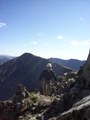
further along the ridge, South Elbert on left, Elbert on right
on South Elbert, La Plata in the back
looking down into the basin I came up
on the saddle looking toward Elbert
About the time I reached South Elbert, I saw someone up ahead along the ridge. At 10:25 I reached the summit of Elbert, and met tmatthews from Colorado Springs. A third climber summited from the other side, and proceeded to light a cigarette! Very strange behavior, indeed. I hunkered down out of the wind and rested with a snack of summer sausage. It's just not as good without cheese and crackers.
on the summit, Massive in the back
Terry (tmatthews) and I walked out together, and it was nice to have company on the descent. By the time I started down off the ridge, my legs felt worked, but it was good to feel pushed a little bit. As we got down lower into the basin, we got some consistent sun and it was a really pleasant walk.
the last view of La Plata from the lower basin
This was a far more challenging route than the standard Elbert route, but if you're looking for the challenge and want to work on your "climbing legs," I would recommend it. It's close to Denver, few people, and the basin is pretty, although not transcendent. A challenging and enjoyable first day to the season. I'll be back to this route again.
Thumbnails for uploaded photos (click to open slideshow):
I then multiplied the number of miles on the route by the feet per mile gained to get a number that might be a more accurate measure of endurance for each route. This made quite a bit more sense, but was still not always consistent with what my legs tell me at the end of a hike. I gotta get some friends. Great talking to you as well, Terry.
I like to calculate my ascent in "chases" per hour. Chase = (distance (in miles))/2 + (elevation gain (in feet))/1000. So, something that's 8 miles and 1000 elevation gain is equivalent to something that's 6 miles and 2000 feet gain, which I think is about right.
Caution: The information contained in this report may not be accurate and should not be the only resource used in preparation for your climb. Failure to have the necessary experience, physical conditioning, supplies or equipment can result in injury or death. 14ers.com and the author(s) of this report provide no warranties, either express or implied, that the information provided is accurate or reliable. By using the information provided, you agree to indemnify and hold harmless 14ers.com and the report author(s) with respect to any claims and demands against them, including any attorney fees and expenses. Please read the 14ers.com Safety and Disclaimer pages for more information.
Please respect private property: 14ers.com supports the rights of private landowners to determine how and by whom their land will be used. In Colorado, it is your responsibility to determine if land is private and to obtain the appropriate permission before entering the property.


")
")
")
")
")
")
")
")
")
")
")