Download Agreement, Release, and Acknowledgement of Risk:
You (the person requesting this file download) fully understand mountain climbing ("Activity") involves risks and dangers of serious bodily injury, including permanent disability, paralysis, and death ("Risks") and you fully accept and assume all such risks and all responsibility for losses, costs, and damages you incur as a result of your participation in this Activity.
You acknowledge that information in the file you have chosen to download may not be accurate and may contain errors. You agree to assume all risks when using this information and agree to release and discharge 14ers.com, 14ers Inc. and the author(s) of such information (collectively, the "Released Parties").
You hereby discharge the Released Parties from all damages, actions, claims and liabilities of any nature, specifically including, but not limited to, damages, actions, claims and liabilities arising from or related to the negligence of the Released Parties. You further agree to indemnify, hold harmless and defend 14ers.com, 14ers Inc. and each of the other Released Parties from and against any loss, damage, liability and expense, including costs and attorney fees, incurred by 14ers.com, 14ers Inc. or any of the other Released Parties as a result of you using information provided on the 14ers.com or 14ers Inc. websites.
You have read this agreement, fully understand its terms and intend it to be a complete and unconditional release of all liability to the greatest extent allowed by law and agree that if any portion of this agreement is held to be invalid the balance, notwithstanding, shall continue in full force and effect.
By clicking "OK" you agree to these terms. If you DO NOT agree, click "Cancel"...
Crestone Needle: 14,197
Route: Standard route (South Colony Lakes over Broken Hand Pass)
Crew: The "Fab 4" (explained later.)
Climb date: Sunday, June 08, 2010
Start Time: 4:22am
End Time: 4:47pm
Total Time: 12 � hours (total hiking/climbing/summit time)
Trip Length: 13.3 miles (according to my GPS)
Elevation Gain: 4,400 feet (according to 14ers.com)
Looking on 14ers.com, there has only been one trip report since September of 2009. So, I am adding some extra info that may benefit those in the climbing community looking to do this climb. (At least I hope it's beneficial.)
Our quest for "The Needle" began on Saturday, June 7. This peak has the reputation of being one of the harder 14ers in the state. We decided to camp at the trailhead the night before in order to get SOME sleep and an early start. (I am no longer a fan of getting up at midnight, driving across the state, climbing all day, and then driving all the way back home trying not to fall asleep!) For me, it works better camping at the trailhead.
On our drive over to the South Colony Lakes area Saturday night, Paul suggested we stop in Penrose, CO at the truck stop/SubWay sandwhich shop to get some dinner. This turned out to be a smart idea as the convenient store/SubWay shop in Westcliffe, CO closes at 8pm. In fact, from my last 3 climbs involving a return through Westcliffe, I can attest, there are NO restaurants open after 8pm. Ravenous outdoorsmen, be forewarned!
This alpine start began pre-dawn at the new parking lot that has just been established this last year. If you haven't been up there since last fall, you'll find that there is a big honkin' steel gate that prevents you from driving up to the previous "4WD TH." This gift from the forest service adds 2.6 miles each way to your hike. Bill Middlebrook has already accounted for this, here in his route descriptions. They have also put in a few tent sites at this TH and have added some new signage. Note, in the dark we missed the new trail that actually leaves this parking area. We ended up bush-wacking our way along until we found the really nice, new bridge that crosses South Colony Creek. So, to find the actual start of the trail, go to the new signs at the west end of the parking lot, and turn LEFT, don't go straight into the forest!
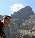
Here we are ready to start the day....the "Fab 4." For some reason, Paul posted on his Facebook page the day before the climb, that the four us going on this climb are the "Fab 4." (I still don't know why he wrote that.) Britt (globreal), Paul, (paulperea), Steve (sgladbach), John (Fepic1),
As it turns out, there can be up to 5 creek crossings on this trip; four of them before you reach the lakes. Not all of them are "bridged." This was John showing us how to do it. However, as you can see, it's almost not worth trying to keep your boots dry! (This shot was on our return when the creek was higher due to the warm afternoon temperatures.)
We heard that there was some snow up around the lakes but no snow from the "new 2WD TH" up to what use to be called the old "4WD TH." Therefore, we opted to save the weight and leave the snowshoes in the truck. Now, there are two ways to get to the lakes; a somewhat direct route which heads from the "old 4WD TH," northwest through the trees, or follow the "old road" that loops southwest along the canyon walls which is � mile longer. In using our "mountain minds" trying to guess which route will be best this time of year, we decided to take the longer route. Our rationale, the weather had been sunny, with highs in the 60's and lows in the 40's the entire week previous, and therefore the sun will have done it's work. We figured the route in the trees would still full of snow like our climb last weekend up to Snowmass Mnt. Wrong on both ideas. However, we got extremely lucky as the snow was actually firm and we didn't encounter much postholing at all on the longer loop route. Our decision to not take snowshoes turned out to be the right choice.
When summer finally arrives in the rockies, it's a wonderful thing. Reaching the campsites around the lower lake, the forest was green and beautiful. Steve and Paul are contemplating our next phase of the trip...Broken Hand Pass.
For some reason all of us were dragging today. We all commented on feeling sluggish. We thought leaving the heavy snowshoes back at camp would help. It didn't seem to. Maybe it was the weight of the crampons in the pack slowing us down. This being the leeward side of the mountain, we knew we would want them here ascending Broken Hand Pass.
Having traveled this route in late July 2009 when I climbed Crestone Peak, I can tell you, doing this as a snow climb is WAY better than when it's all melted out. It's nothing but a scree-fest then. The climb gets a lot steeper the higher you go and therefore, the ice axe was welcomed weight worth carrying....especially on the return trip! (photo by paulperea)
After reaching the saddle of Broken Hand Pass, you turn right or NW. It is hear that you are treated to a good look at where you are heading...up....way up! From here you climb about 1,350 feet in � mile. We head for the east gully which currently still has snow remaining in it. You certainly can't tell from this photo, but this is one steep, grizzly mountain!
This mountain is made up of conglomerate rock. It's like all kinds of rocks fused together with concrete.
After reaching the east gully, things change dramatically! It's at this point where this little jaunt turns from a hike to a climb!
I've climbed Wetterhorn Peak which is rated as Class 3. This peak is rated Class 3 on 14ers.com. What? This didn't feel like any class 3 to me! In fact, after this first section in the east gully, I asked Steve, okay...what would you say that pitch was? His reply, "oh, that was probably a 5.2, 5.3." I'd believe it!
And yeah, there was some exposure to be found! (photo by paulperea)
Even though it's quite steep, the solid rock helps makes it somewhat more comforting. I said "somewhat." I found myself really having to pay attention to each move, taking special care to secure "4 points of contact" constantly telling myself, "don't rush,"
"go slow," & "take your time, we've got all day." (photo by paulperea)
As we ascended the gully, we viewed some amazing gendarmes along the way. These rocks shouldn't stick together like this!
One of Paul's Facebook quotes after our trip...."This was a climb not a hike, used all 4's most of the day." Here is Paul using "all 4's"....being followed up by John.
It says on the 14ers.com route description: "Climb approximately 300' in the east gully until you reach a section where the center of the gully becomes deep and narrow. Above this area, the gully becomes more difficult. Yep, I'd agree with that!
14ers goes on to say... The easiest/standard route (Class 3) involves crossing from the east gully to the west gully."
Steve has climbed this peak approximately 20 times (that's right 20!). He was able to find the place to cross over to the west gully. Crossing the snow in the center of the gully was a bit challenging. While it looked harmless enough, Steve's first step on the snow had his feet go right out from underneath him.
Underneath that snow was a layer of glazed ice. Thankfully he was able to self-arrest and not slide to the bottom of the gully.
Seeing Steve's fall on the ice, the rest of us decided to put our crampons back on even though it was less than 20 feet across. And Steve had some webbing in his pack. I belayed him across and then he belayed us across. (I prefer to play it safe.)
Going up and over this rib I think just may be the crux move. While it's a short climb, it's got some vertical to it!
(taken on the descent)
This is John just after crossing over into the west gully which is marked by a cairn. I think you can tell, we're not in Kansas anymore.
Higher up this west gully starts to open up, and we are rewarded with some amazing views. Steve takes in the scenery over the South Colony Creek valley and the Wet Mountains out to the east. Hidden down in those trees below is where country road 120 (the approach road) lies. Somewhere in there is where we began our day.
Even though it was a slow and sluggish climb, the hard work and diligence pays off. We made it successfully to the top of this distinctive mineral composition in about 6 hours and 45 minutes. We didn't care that we were slow today. The weather was gorgeous and about as perfect as you can get. Paul was the first to reach the summit about 11:15am.
Steve and John earned a well-deserved rest. Time to sit, eat lunch, and enjoy the views of 14,064 foot Humboldt Peak. Steve offers everyone some of his salami and cheese sandwiches. Wow! That was so much better than my peanut butter and honey sandwich!
The views to the north of Crestone Peak, East Crestone, and Kit Carson off in the distance, under these clear blue skies are nothing short of amazing.
Here we are the "Fab 4" on the summit of the Crestone Needle, enjoying what has become a celebratory summit snack tradition....sugary ORANGE SLICES. Yum! Paul, John, Cooper, Steve, Britt
Now, let me give a word of caution to the novice climber doing this rock pile for the first time. This peak can really be a route finding nightmare! There are no easy trails to follow that are carved into the rock like happens on forest floor or tundra. Had we not been with someone who has climbed this thing more times than John has in his total 14er peak list, I'm sure we would have gotten way off route, stuck, or lost. It may look easy, but all this rock can get confusing when buried in the bottom of a deep gully. At one point I went my own way. I didn't veer back right and follow Steve. I looked up the gully I was in and thought, "oh, it just goes to the top," and maybe it did. However, I went my own way and my route got steeper and steeper. So, later I decided I should crawl up the side of "my gully" and look over into the true "west gully." It was much easier terrain over there. Now, to get back to following the trip leader. Crap! To do so involved another 5.3 move. Scarry! I learned my lesson. Just follow the guy who has been here before. And that's the moral of this little suggestion...if you can, go with someone who has climb this peak before. This is Paul saying, "Did we come up over here or over there?"
What can appear from a distance is a nothing more than a giant mound of bland, browish rock, can come alive we you observe the detail. This lichen had the most brilliant color growing underneath some overhanging rock.
The part we all looked forward to the most, was the glissade down Broken Hand Pass. And it proved to be one of the most invigorating parts of the day. This butt slide was fast and fun! Aside from skiing, glissading has got to be the best way to descend down a mountain.
And this glissade went from just a short ways below the saddle, practically all the way to the lake! Paul got tired off filling his shorts with snow so on the last section he dove face first and went for it! Every now and then grown men act just like boys, right?
We had such a diversity of terrain and ecosystems on this trip. One minute we were on a forest floor, the next minute on snow, then we would be on tundra in an alpine environment, then on rock, and then it would all change again. Passing by this crevasse was an example. Steve must be walking on snow that is 10 feet deep here.
A simple fact is that a slip of a handhold, a rock slipping away, a cornice breaking out from underneath us, could quickly result in death. We prayed as a group before we started our climb that God would keep us safe and allow us to return safely to our homes and families. I know that as humans we are as frail as the flowers on the forest floor and we get to trod through these mountains only as He gives us another day. He answered our prayer for safety, and while I don't think we, as the "Fab 4" are too fabulous, God gave us another fabulous day to enjoy His creation. Steve's boot next to a new crop of White Globe Flowers.
Psalm 103:15-17
As for man, his days are like grass, he flourishes like a flower of the field;
the wind blows over it and it is gone, and its place remembers it no more.
But from everlasting to everlasting the LORD's love is with those who fear him.
Thumbnails for uploaded photos (click to open slideshow):
I totally agree with you about route finding on the needle! One thing that helped me was the little flag on top of the sharkfin, was it still there? How does this rank on your favorites list?
Awesome report Britt! Good to see you guys had a great time.
And I second Bill‘s comments - it is definitely Class 3 in the later summer - but hey, Steve‘s good at making things interesting - right? Either way, I was the one route finding when I went up last year, and there are definitely a few places you can miss if you aren‘t paying attention!
JA_son27, I didn‘t notice a flag. In fact, I didn‘t notice the sharkfin. Favorite? Yep, one of the top peaks. Definitely one of my top climbing days ever!
Bill, no ice on the rock...just in the gully. But I guess that makes the point...even with someone who has been there, route finding is a moving target that‘s hard to hit.
ctb, hey...don‘t limit yourself. The rock is solid and makes a big difference.
Kevin...yeah there‘s Class 3 in there...it‘s just hard to stay on it...even if you ARE paying attention!
Excellent report Britt! I enjoyed every bit of your report. I climbed the Peak and traversed to the Needle last August and it definitely is my favorite hike/climb to date. Kudos for taking your time and emphasizing safety.
Right now, the gully has some hard ice in it. You may find yourself, as we did, opting foe periodic harder scrambling to avoid crossing back and forth across the gully to stay on the easiest, cairned route. Most spots, the two choices are only a matter of 15-20 feet apart. Pick you preferred terrain. (The overall best route doesn‘t change.)
Thanks for the great report and pictures. A group of us are hiking to S. Colony Lakes Saturday (6/12) afternoon and climbing Humboldt on Sunday (6/13). Your report & pictures provide a great account of snow conditions and is perfect intel for our climb.
is looking on up the east gully from the top of the cross-over.
Pic 18 is looking down into the east gully from the top of the cross-over.
Pic 19 is taken in the west gully looking at John who just came over the cross-over into the west gully from the east gully.
Thanks for this nice report, it was useful to us last week when we attempted Crestone Needle. We did not make it because of weather and time but we will try again.
By the way, how did the dog do in your trip? there are some pretty steep rock climbing there, did he jump the crossover point? it is amazing he made it, what a cute climber dog!
Oh, and if you were doing 5.2 and 5.3 pitches, Steve was making you work waaayyyy too hard unless there was ice covering the easy stuff. When dry, it's definitely possible to keep the climbing at Class 3.
for the pictures. I needed recent beta on this one and this report is right on time. If Steve led the team through 5.2-5.3 I'm sure there was good reason behind it. I think Class 3 is over-rated anyway .
Excellent Trip Report and photos! You really captured a lot of my feelings about what it must be like to climb that Peak. A couple of years ago I went up and over Broken Hand pass on the way to Crestone Peak but we chose not to climb it that day and turned back. That glissade really looked awesome. Glad everything went well and you had a stellar weather day.
It was great to link up with you guys again. This group works well together I hope to do it again soon. The short rock climbing sections were great practice for someone without a rock climbing background they were short and had plenty of holds. The glissade was the funnest part of the day.
Caution: The information contained in this report may not be accurate and should not be the only resource used in preparation for your climb. Failure to have the necessary experience, physical conditioning, supplies or equipment can result in injury or death. 14ers.com and the author(s) of this report provide no warranties, either express or implied, that the information provided is accurate or reliable. By using the information provided, you agree to indemnify and hold harmless 14ers.com and the report author(s) with respect to any claims and demands against them, including any attorney fees and expenses. Please read the 14ers.com Safety and Disclaimer pages for more information.
Please respect private property: 14ers.com supports the rights of private landowners to determine how and by whom their land will be used. In Colorado, it is your responsibility to determine if land is private and to obtain the appropriate permission before entering the property.


")
")
")
")
")
")
")
")
")
")
")
")
")
")
")
")
")
")
")
")
")
")
")
")
")
")
")
")
")
")