| Peak(s): |
Mt. Massive - 14,427 feet "South Massive" - 14,157 feet "Massive Green" - 14,311 feet |
| Date Posted: | 05/24/2010 |
| Modified: | 06/10/2010 |
| Date Climbed: | 05/22/2010 |
| Author: | travis19877 |
| Peak(s): |
Mt. Massive - 14,427 feet "South Massive" - 14,157 feet "Massive Green" - 14,311 feet |
| Date Posted: | 05/24/2010 |
| Modified: | 06/10/2010 |
| Date Climbed: | 05/22/2010 |
| Author: | travis19877 |
| Mt Many False Summits (Massive 5/22/10) |
|---|
|
Mount Massive - 2/22/10 Introduction This hike included myself, my Dad (Boomerang,) Kevin (Kevin8020,) and a friend from school new to 14ers, Jared. Both Jared and Kevin elected to camp at the trailhead (North Halfmoon Creek,) and my Dad and I, due to an untimely baseball banquet, awoke at 12:55 and drove down the following morning. We arrived at the trailhead at 4:30, and I got to put my brand new Princeton Tec headlamp to use! We were able to make it all the way to the summer trailhead, and Jared and Kevin slept in a tent just short of it. At one point Jared got so hot he had to sleep completely shirtless, quite an encouraging sign considering i've stayed overnight three times and froze my butt off everytime! We all brought snowshoes, and with the exception of my dad using them because of personal preference, they stayed in the car. The majority of the hike was on dry ground, solid snow, or melted snow. With the exception of maybe an hour window when the snow was at prime "post-holling" conditions, they were not needed. An ice axe is next to a must have for this trip, one for some dicey ridge climbing in high winds near the summit(s), and two for time saving glissades down half the mountain. Crampons never hurt on these spring climbs, especially when there are steep slopes like you will see on Massive. The Hike We hit the trail at about 5:00 Am and set off at a somewhat brisk pace. We only took a few breaks for breakfast until we reached the willow field at approximately 2 miles in. Everyone sat down here for the first extensive rest and figured it was time for a picture. , Jared, and Me.") Unfortunently the sun wasn't far behind our backs, as you can see from the last picture. So, my new beautiful headlamp didn't get to see THAT much action. We hiked through a moderate section with several creek hopping sections that gave Jared a nice intro to spring 14ers. This was a fun time to show him the tips and tricks of tightening backpacks so different body parts feel less stress, and of course letting him try our favorite snacks so that he can figure out what he likes. At this point the weather was very fair, we all elected to strip down to at the very least a fleece layer, and I even chose to wear just a t-shirt. A beautiful Colorado sunrise began to reveal itself to us.  After a short section of somewhat difficult route finding, we turned right at the junction instead of continuing on towards the lakes.  We then hiked a quarter of a mile on unusually nice carved out steps on a trail. I was already on a brisk pace, which was weird to the rest of the group, especially considering i got maybe 3 hours of sleep. Anyways, as I was scouting out the route ahead, a BIG marmot ran passed the trail several hundred feet ahead. Immediatly and without thought, I completely bolted. Now that I think about it, it's weird lol, but thats just how i reacted haha. For all you wondering the outcome of the witty marmot, he did manage to hide from me long enough to drive me on towards my real goal.  Shortly following this wild marmot hunt, I looked back to see our route finder extraordinaire analyzing his map to verify we were on route to the summit.  At this point there were two opinions on the route, both leading to the same place. Option A involved steep snow climbing, and option B involved some fun rock scrambling, I might even go as far as to call it "Bouldering." Anyways, Jared and I chose the rock route, and my Dad and Kevin took the snow route. This worked out because about halfway through their section, they both realized the snow was steep, my Dad strapped on snowshoes for traction and Kevin threw on his crampons. It was during this intermission that my Dad snapped off another shot of a good looking Mt Elbert.  Following the fun rock climb, we rendezvous at the top of the basin. It was only a short while after that Kevin and Jared came to the realization that they weren't going to make the summit. It was a pretty tiring trip, and Jared's first extensive hike. Kevin made the call for two reasons, one because he was tired himself after summitting on Antero the day before. Two because he felt much more comfortable accompanying Jared down than leaving him sitting on a dangerous mountain. My Dad and I however, were in it for the summit, and more.  just shy of South Massive's summit.") My dad and I gained our first Sub Summit within an hour of Jared and Kevin's turn around. This was South Massive, not a ranked fourteener because it doesn't meet the standards for being it's own peak. Anyways, after summiting the wrong peak, and realizing our fault, we began a long ridge hike with high winds (50+) and many many false summits. On this adventure, we quickly bagged South Massive, Massive Green, and Mt Massive. We did not, however, have the energy to grab North Massive.     Note: I have MANY other beautiful summit pictures, I could see the Sangres, The Elks, and numerous mountains from the Front Range. If anyone wants to see these, contact me. They are above 12 megapixels, so I cannot upload them without going through a big hassle. We began a fast downclimb after meeting a few skiers on another sub summit. After a fun initial glissade we found that the snow was a little to slushy to safely stop and I didn't feel comfortable for a good while longer. Soon after however, we found a nice patch of snow where we managed a glissade that lasted a couple hundred yards. Here though we had to move over to a rock patch because the snow was no longer as deep, and it was pretty much a minefield. Minefield; a word we used many times on the decent whilst avoiding shallow sections of snow with unseen rocks hiding below. Note: We then pulled over and watched skiers descending, if you know who these skiers are or are them. We have some excellent video of your descent, so if you would like to see that please contact me. After Hike After making it back to the car, it was a relatively boring post - hike. We changed out of our muddy clothes, and moved over to Dillon for a nice dinner at Arby's. Kevin and Jared, after ending the trip early. Made way back to camp and took a nice nap, here they waited for us, and ended up leaving about 5 minutes before we arrived. My only regrets are.. NOT USING SUNSCREEN. I hate sunburns. I really don't understand how i forgot, but i most definitely did. Now i get to experience Exam week walking around looking like a racoon. Thankfully I get to avoid studying by writing up a TR =) Summary Date Climbed - 5.23.10 Start Time - 5:00 Am Summit Time - 12:00 Pm Finish Time - 3:30 Pm Distance Hiked - 7.45 Miles Elevation Gained - 8,600 feet Route Ascended - SW slopes Route Descended - SW slopes Difficulty - Class 2-3 Weather - Sunny with High Winds Trail Conditions - 1/2 dry 1/2 snow covered. Some "postholling". Descent was very wet due to fast snowmelt. (Info taken from my Dad's fourteener passport. Credit to Boomerang) Thanks for reading! Thumbnails for uploaded photos (click to open slideshow):  Left to right, Kevin (Kevin8020), Jared, and Me.")
 Sunshine on Mt. Elbert")
 Turning right at the junction to the lakes.")
 A marmot caught my eye as I sprint towards its exposed burrow.")
 The routemaster carefully analyzes our path.")
 Again, Mt. Elbert lookin' good.")
 My dad (Boomerang) just shy of South Massive's summit.")
 Dad hiking the ridge to Mt Massive summit, South Massive in the background.")
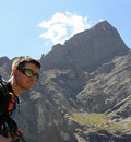
 Me with the final pitch to the last of the false summits, belive me there were lots!")
 \"Oh no this isn't it, oh well just one more..!\"")
 At Last!")
 Another massive sub summit.")
|
| Comments or Questions | |||
|---|---|---|---|
|
Caution: The information contained in this report may not be accurate and should not be the only resource used in preparation for your climb. Failure to have the necessary experience, physical conditioning, supplies or equipment can result in injury or death. 14ers.com and the author(s) of this report provide no warranties, either express or implied, that the information provided is accurate or reliable. By using the information provided, you agree to indemnify and hold harmless 14ers.com and the report author(s) with respect to any claims and demands against them, including any attorney fees and expenses. Please read the 14ers.com Safety and Disclaimer pages for more information.