Download Agreement, Release, and Acknowledgement of Risk:
You (the person requesting this file download) fully understand mountain climbing ("Activity") involves risks and dangers of serious bodily injury, including permanent disability, paralysis, and death ("Risks") and you fully accept and assume all such risks and all responsibility for losses, costs, and damages you incur as a result of your participation in this Activity.
You acknowledge that information in the file you have chosen to download may not be accurate and may contain errors. You agree to assume all risks when using this information and agree to release and discharge 14ers.com, 14ers Inc. and the author(s) of such information (collectively, the "Released Parties").
You hereby discharge the Released Parties from all damages, actions, claims and liabilities of any nature, specifically including, but not limited to, damages, actions, claims and liabilities arising from or related to the negligence of the Released Parties. You further agree to indemnify, hold harmless and defend 14ers.com, 14ers Inc. and each of the other Released Parties from and against any loss, damage, liability and expense, including costs and attorney fees, incurred by 14ers.com, 14ers Inc. or any of the other Released Parties as a result of you using information provided on the 14ers.com or 14ers Inc. websites.
You have read this agreement, fully understand its terms and intend it to be a complete and unconditional release of all liability to the greatest extent allowed by law and agree that if any portion of this agreement is held to be invalid the balance, notwithstanding, shall continue in full force and effect.
By clicking "OK" you agree to these terms. If you DO NOT agree, click "Cancel"...
Last week I posted a report of getting stormed off the El Diente West Ridge. Since pictures of the lower part of the ridge are posted there, I will pick up this report where that one leaves off. The only new information I have is that when approaching the West Ridge, the Roach guide suggests going to the West end of Navajo Lake and doing a long gradual traverse over scree to the ridge proper. I did that last week and didn't care for it. A nice alternative, and one that took about 30 minutes off the time it took to get to the ridge, is to go just about 1/10 of a mile past the trail intersection with the Woods Lake trail. A sign here says 3/4 mile to Navajo Lake. The trail descends steeply for a while after the sign. When it levels out, look for an animal trail to the creek, cross and head straight up. In a short while you will come out of the trees and be on the scree just slightly east of where you want to be.
On this attempt we camped again at the Navajo Lake trailhead. In our usual fashion, we got an early alpine start, about 7:30 a.m. The day seemed like the weather would cooperate, but by 11:00 there were some nasty looking clouds about and we ducked behind a ridge while a brief snow squall passed by. Seeing mostly clear skys to the west, but hearing thunder to the east, we pressed on.
The first real difficulty was bypassed dropping to the N side of the ridge past one of the very few cairns marking this interesting route. This was one of the trickier sections where trying to stay on the ridgecrest turned out to be unwise. After a while we scrambled around to the S side again and found this lovely section to climb.
After this section there was some very interesting climbing traversing right on what might be the most technically challanging bit. I brought a 100' length of 7 mil rope and a couple slings for anchors and used it several times to belay Elly past some of the steeper pitches.
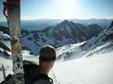
About 1/2 way througth the difficulties of the ridge we took these pictures looking both ways.
Looking back gave a nice sense of accomplishment.
But looking ahead it seemed like there was much more to be done. In fact, from here the climb went quite quickly and it was much less difficult than it appeared.
For the most part the route stays on the S side of the ridge. There is a very prominent gray gully. Once you find yourself here you are nearly finished. Access the ridge by this gully and finish on the ridge proper or just to the N side. The next image is looking down this gully.
And then from the same vantage looking back down the ridge.
And looking up toward the summit after exiting the gray gully.
When you see the dayglow green moss it is an easy scramble to the top, just a few minutes away.
Elly on the summit with Mt. Wilson in the background.
And me looking a little too relaxed.
I had done the traverse from Mt. Wilson to El Diente years ago and descended the North Slope of El D. so this would be the first time going the other way on the ridge. I remembered most of the route, but had forgotten the descent at the end before getting to Mt. Wilson. Getting up from the low spot between Mt. Wilson and the El D traverse proved a little trickier than expected, especially since we were not prepared for any snow travel. When we finally did top out and could look across to see Wilson Peak I realized I had left my camera somewhere down below. I will remember the route better now, having done that 300 vertical feet three times in succession.
At 5:30 p.m. we decided we might as well get on top of Mt. Wilson again. It was only about 10 minutes up from where we would begin our descent back into Navajo Basin.
It turned out to be a beautiful evening. Here is a look back at the descent from Mt. Wilson from high up in Navajo Basin.
This next picture has nothing to do with the climb, but I thought it was cool.
Heading home past Navajo Lake.
And a final look up at the West Ridge of El Diente.
Thumbnails for uploaded photos (click to open slideshow):
The traverse is grade III and I would say it is an easier III. The West Ridge is a solid IV and getting anywhere offroute you will easily find yourself on 5th class rock.
The West Ridge took about three hours once we accessed the ridge, the traverse about 2.
In short, on the traverse, you would have to try hard to fall. On the West Ridge you have to try hard not to.
Looks like a blast! I am heading up there this week and was thinking of going up Kilpacker and then traversing and descending the north slope of Mt. Wilson. Can you help me out with the snow conditions? I wonder because you mention not being prepared for snow travel, is the north slope Mt Wilson gulley carrying snow and require crampons?
I didn‘t spend enough time in Kilpacker to say what you will find there. As for the North Slope of Mt. Wilson, we kept our feet dry on the descent from Mt. Wilson. AVOID the temptation to descend the gullies that appear as the obvious way down. Instead, traverse high on Mt. Wilson ridge following cairns all the way till you overlook the Wilson glacier then go down parallel to the Wilson Glacier. Don‘t get on the snow, but angle always to climbers right to find a good trail back to the Navajo Basin trail. Doing this we went from the summit of Mt. Wilson to the trail in under an hour and never set foot in any snow at all.
How would you compare El Diente's West Ridge to the ElDiente/Mt Wilson traverse?
Steve
Caution: The information contained in this report may not be accurate and should not be the only resource used in preparation for your climb. Failure to have the necessary experience, physical conditioning, supplies or equipment can result in injury or death. 14ers.com and the author(s) of this report provide no warranties, either express or implied, that the information provided is accurate or reliable. By using the information provided, you agree to indemnify and hold harmless 14ers.com and the report author(s) with respect to any claims and demands against them, including any attorney fees and expenses. Please read the 14ers.com Safety and Disclaimer pages for more information.
Please respect private property: 14ers.com supports the rights of private landowners to determine how and by whom their land will be used. In Colorado, it is your responsibility to determine if land is private and to obtain the appropriate permission before entering the property.


")
")
")
")
")
")
")
")
")
")
")
")
")
")