Download Agreement, Release, and Acknowledgement of Risk:
You (the person requesting this file download) fully understand mountain climbing ("Activity") involves risks and dangers of serious bodily injury, including permanent disability, paralysis, and death ("Risks") and you fully accept and assume all such risks and all responsibility for losses, costs, and damages you incur as a result of your participation in this Activity.
You acknowledge that information in the file you have chosen to download may not be accurate and may contain errors. You agree to assume all risks when using this information and agree to release and discharge 14ers.com, 14ers Inc. and the author(s) of such information (collectively, the "Released Parties").
You hereby discharge the Released Parties from all damages, actions, claims and liabilities of any nature, specifically including, but not limited to, damages, actions, claims and liabilities arising from or related to the negligence of the Released Parties. You further agree to indemnify, hold harmless and defend 14ers.com, 14ers Inc. and each of the other Released Parties from and against any loss, damage, liability and expense, including costs and attorney fees, incurred by 14ers.com, 14ers Inc. or any of the other Released Parties as a result of you using information provided on the 14ers.com or 14ers Inc. websites.
You have read this agreement, fully understand its terms and intend it to be a complete and unconditional release of all liability to the greatest extent allowed by law and agree that if any portion of this agreement is held to be invalid the balance, notwithstanding, shall continue in full force and effect.
By clicking "OK" you agree to these terms. If you DO NOT agree, click "Cancel"...
Our day began early with a 2:00 am departure from Leadville. There were still some people milling around on Harrison avenue after bar closing time. We had not been able to get in much party time considering our 7:30 pm bedtime the following evening! After suffering through some moderate bumpiness in the dark on CR 365 we arrived at the trailhead unscathed around 3:15 am.
Brian, Steve, Trent - headlamps on and ready to go!
The air was crisp, but temperatures were still above freezing. The night was clear and moonless, so we had a spectacular view of the night sky when we extinguished our headlamps. The trail was very easy to follow in the dark and we were well into Horn Fork Basin and above tree line before daylight.
Looking back down the basin with early morning light on Yale
Carrie and Steve making way up out of basin
Brian working his way up the slope with view of Mt. Yale and Bear Lake in the background
Steve and Trent approaching the ridge for the final push to the summit
Approaching the summit crux
Steve determining what line to take - although not obvious in the photo, there are actually several well worn paths and the rock is very stable with plenty of handholds and footholds.
After a brief and invigorating scramble, you soon find yourself atop the small summit block This took us a little over 5 hours from the time we left the trailhead.
Trent celebrating number 7 14er for this trip with Mt. Columbia (left) and Mt. Yale (right) in the background.
Carrie briefly celebrating her 6th summit before deciding the exposure was a little too extreme for her liking!
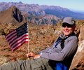
Several other views from the summit
After summiting Harvard, Carrie and Brian turned back while Steve and Trent began the traverse over to Columbia. The traverse proved to be even more arduous than anticipated (even after reading many accounts of people saying exactly the same thing!). Matters were complicated by first descending into the wrong gully and then questionable weather moving in. Columbia was never officially obtained because with audible thunder and nasty looking clouds we each beat a retreat to the relative safety of 'closest' tree line. This might have been too much paranoia as many hikers were continuing to ascend Columbia. But at the end of the day, we all made it back to the trailhead and were all smiles as we recounted the days activities and drama.
This hike was voted the most "intense". Everything from the early start, long distance, and tight summit area made this a great hike that none of us will soon forget!
Brian enjoying life on the way back down!
Ominous clouds building
Nice easy trail through the forest
This bridge is an example of the trail's high degree of maintenance
Ahhh...trailhead!
This hike concluded our trip. DeCaLiBron, Yale, Massive and Harvard made for a wonderful four days. We had plans to do Grays and Torreys on the way out, but rain in the front range and our long day on Harvard made us reconsider. Instead, we opted for a leisurely breakfast at Doc Hollidays and then made our way back to DIA and our flights home. We had a great time on this trip and are already anticipating our next venture to the Colorado 14ers!
Thumbnails for uploaded photos (click to open slideshow):
It took us about 5 hours up and 4 hours down at a fairly leisurely pace. You really can make good time for the first portion of the hike (even in the dark) because the elevation gain is very moderate.
Caution: The information contained in this report may not be accurate and should not be the only resource used in preparation for your climb. Failure to have the necessary experience, physical conditioning, supplies or equipment can result in injury or death. 14ers.com and the author(s) of this report provide no warranties, either express or implied, that the information provided is accurate or reliable. By using the information provided, you agree to indemnify and hold harmless 14ers.com and the report author(s) with respect to any claims and demands against them, including any attorney fees and expenses. Please read the 14ers.com Safety and Disclaimer pages for more information.
Please respect private property: 14ers.com supports the rights of private landowners to determine how and by whom their land will be used. In Colorado, it is your responsibility to determine if land is private and to obtain the appropriate permission before entering the property.


")
")
")
")
")
")
")
")
")
")
")
")
")
")
")
")