Download Agreement, Release, and Acknowledgement of Risk:
You (the person requesting this file download) fully understand mountain climbing ("Activity") involves risks and dangers of serious bodily injury, including permanent disability, paralysis, and death ("Risks") and you fully accept and assume all such risks and all responsibility for losses, costs, and damages you incur as a result of your participation in this Activity.
You acknowledge that information in the file you have chosen to download may not be accurate and may contain errors. You agree to assume all risks when using this information and agree to release and discharge 14ers.com, 14ers Inc. and the author(s) of such information (collectively, the "Released Parties").
You hereby discharge the Released Parties from all damages, actions, claims and liabilities of any nature, specifically including, but not limited to, damages, actions, claims and liabilities arising from or related to the negligence of the Released Parties. You further agree to indemnify, hold harmless and defend 14ers.com, 14ers Inc. and each of the other Released Parties from and against any loss, damage, liability and expense, including costs and attorney fees, incurred by 14ers.com, 14ers Inc. or any of the other Released Parties as a result of you using information provided on the 14ers.com or 14ers Inc. websites.
You have read this agreement, fully understand its terms and intend it to be a complete and unconditional release of all liability to the greatest extent allowed by law and agree that if any portion of this agreement is held to be invalid the balance, notwithstanding, shall continue in full force and effect.
By clicking "OK" you agree to these terms. If you DO NOT agree, click "Cancel"...
San Luis Ski Descent
Trailhead: Equity Mine 4WD at 11,400'
Ascent of South Ridge
Ski Descent of East Face and Upper Cochetopa Creek
5200 vertical, 13 miles
San Luis has been a bit of a thorn in my side for the past few years. I intended to ski it during the winter the past few seasons, but never seemed to get the right combination of conditions, time and partners to do it. On Saturday, my first view of the Yawner Gullies, a route I intended to ski, made we wonder if this mountain was toying with me.
Photo: Debbie Baker
I knew however, I had the right partners:
Debbie
Photo: Joe Brannan
Prakash:
Photo: Joe Brannan
After whacking some willows instead of following the road, we hit the first pass on the day. If you do this route and you can find the old mining road which is not on the map, follow it to around 12,300', it will make your life easier. The snow was still very firm so we took care while getting down over the cornice.
White-N-Brown:
Photo: Joe Brannan
We then traversed on skis down across the Upper West Fork of Spring Creek Basin.
Traversing:
Photo: Joe Brannan
Along the way, it was clear we didn't want to backtrack this exact route in the heat of the day.
Objective Hazards:
Photo: Joe Brannan
After Debbie and Prakash reluctantly ditch their sticks...
Photo: Joe Brannan
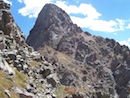
...we headed up the Colorado Trail to our next pass. A few of the La Garita Mountains hold interesting terrain:
Rugged Corner of the La Garitas:
Photo: Prakash Manley
Next? Traverse across the Upper East Fork of Spring Creek Basin.
I Hope It Froze:
Photo: Joe Brannan
Promising:
Photo: Joe Brannan
Unfortunately, it didn't freeze. We found conditions best described as swimming...
Perhaps Freestyle?
Photo: Joe Brannan
We knew the ridge route on the way back would be best at this point. Staying low on the descent did afford some spectacular Hoodoo viewing:
Ancient Volcano Hoodoos:
Photo: Joe Brannan
Next? The final climb up the gentle yet deceivingly long South Ridge.
1600 vert to go:
Photo: Joe Brannan
Springtime is here. The clouds briefly appeared threatening over Organ:
Organ Positron?
Photo: Joe Brannan
But as is common in the early spring, there just wasn't enough juice in the sky to get the clouds really building. We slogged up to the summit and claimed our kill:
Summit Brutality:
Photo: Joe Brannan
After I scoped out the East Face and deemed it a go for skiing, we took a half hour snooze and ate some lunch. The air is so fresh up there. Eventually we decided to part ways. Debbie and Prakash back down the South ridge, me down into Cochetopa Creek...
Summit Ski #53:
Photo: Debbie Baker
Tight But Continuous Off the Top:
Photo: Debbie Baker
Fun slush was found on the gentle East Face:
Photo: Debbie Baker
Follow the Snow!
Photo: Debbie Baker
The upper route:
Photo: Joe Brannan
The lower route:
Photo: Joe Brannan
The route, in general:
Photo: Joe Brannan
I climbed back out to the South Ridge, were I found Debbie and Prakash waiting in the sun.
Spot them? (hint, two tiny black dots just right and down from center)
Photo: Joe Brannan
After another four hundred feet of hiking up, we skirted around point 13,155:
This route: UP DOWN UP DOWN UP DOWN UP DOWN UP DOWN UP DOWN UP DOWN
Photo: Joe Brannan
Some scrambling through the crumbling hoodoos:
Photo: Joe Brannan
And yet another climb back out of Spring Creek had us gazing out upon San Luis for the last time:
Photo: Joe Brannan
A long day deserves some Red-N-White:
One left... thanks for following along.
Thumbnails for uploaded photos (click to open slideshow):
I admit I was skeptical when you told me you were going down there. Looks like it held in for you though. Funny, the last time I was up there I believe we stashed some Silver Bullets in that same stream. Good work!
I did this route last summer and wondered about those precarious boulders sitting on top of those spires... they are volcano hoodoos? What does that mean?
Last Memorial Day my partner and I skied the Yawners and were pretty much on continuous snow from the moment we parked his car 3 miles below the normal trailhead until the moment we got back to the car. There‘s no way we would‘ve gone through with it had we seen what you saw at the first pass. Kudos on your perseverance.
Caution: The information contained in this report may not be accurate and should not be the only resource used in preparation for your climb. Failure to have the necessary experience, physical conditioning, supplies or equipment can result in injury or death. 14ers.com and the author(s) of this report provide no warranties, either express or implied, that the information provided is accurate or reliable. By using the information provided, you agree to indemnify and hold harmless 14ers.com and the report author(s) with respect to any claims and demands against them, including any attorney fees and expenses. Please read the 14ers.com Safety and Disclaimer pages for more information.
Please respect private property: 14ers.com supports the rights of private landowners to determine how and by whom their land will be used. In Colorado, it is your responsibility to determine if land is private and to obtain the appropriate permission before entering the property.


")
")
")
")
")
")
")
")
")
")
")
")
")
")
")
")
")
")
")
")
")
")
")
")
")
")
")