Download Agreement, Release, and Acknowledgement of Risk:
You (the person requesting this file download) fully understand mountain climbing ("Activity") involves risks and dangers of serious bodily injury, including permanent disability, paralysis, and death ("Risks") and you fully accept and assume all such risks and all responsibility for losses, costs, and damages you incur as a result of your participation in this Activity.
You acknowledge that information in the file you have chosen to download may not be accurate and may contain errors. You agree to assume all risks when using this information and agree to release and discharge 14ers.com, 14ers Inc. and the author(s) of such information (collectively, the "Released Parties").
You hereby discharge the Released Parties from all damages, actions, claims and liabilities of any nature, specifically including, but not limited to, damages, actions, claims and liabilities arising from or related to the negligence of the Released Parties. You further agree to indemnify, hold harmless and defend 14ers.com, 14ers Inc. and each of the other Released Parties from and against any loss, damage, liability and expense, including costs and attorney fees, incurred by 14ers.com, 14ers Inc. or any of the other Released Parties as a result of you using information provided on the 14ers.com or 14ers Inc. websites.
You have read this agreement, fully understand its terms and intend it to be a complete and unconditional release of all liability to the greatest extent allowed by law and agree that if any portion of this agreement is held to be invalid the balance, notwithstanding, shall continue in full force and effect.
By clicking "OK" you agree to these terms. If you DO NOT agree, click "Cancel"...
Peaks:
Purple Mountain (12,958') - 662nd highest
Augusta Mountain (12,559') - 960th highest
Richmond Mountain (12,501') - 991st highest
Hancock Peak (12,410') - not ranked
Oh-Be-Joyful Peak (12,420') - not ranked
Afley Peak (12,646') - 896th highest
(Not climbed due to weather: Purple Peak, Mount Owen and Ruby Peak)
Approximately 12 1/2 miles horizontal and over 5000' vertical
The Ruby Range is a sub-range of the Elk Mountains located to the northwest of Crested Butte. The range spans from Yule Pass at the northeast end to Kebler Pass at its southwest and forms the eastern boundary of the Raggeds Wilderness. With no fourteeners and only one peak over 13,000' (Mt Owen at 13,058'), this range is largely overlooked by climbers and provides an opportunity for solitude and adventure not usually found on the more popular peaks. My friend Ben and I went into this climb with no real route information and not really know what to expect. Our plan was "simple" enough in concept: Gain the ridge at Yule Pass and stay as close to the crest as we could all the way to Ruby Peak, then drop to Lake Irwin where his wife would pick us up. We even planned to toss 50 pushups in at the end to really beat ourselves up. The ridge crest crosses the summits nine peaks (five ranked 12ers, three unranked 12ers and one 13er) and never drops below 11,700'. We calculated the mileage would be about 13 miles and the total elevation gain about 6,500'. This could be done in a day, but it would be a long one!
We made our way to the appropriately named Paradise Divide where we started hiking just after sunrise. The trail initially contours around Cinnamon Mountain on a former mining road. This road is now the trail, and several mudslides have washed parts of it out. The trail is relatively flat, but due to these washouts and the loose rock on the sides of the trail, extra care should be taken. As we traversed this section of trail, the morning alpenglow coated our first objective, Purple Mountain, in beautiful light.
Purple in Alpenglow
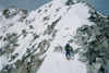
We reached Yule Pass and had a snack/sunscreen break and began our way up the peak. Surprisingly there was a climbers trail if you continued on past Yule Pass a short way. This was the key to the route as it avoided the extremely loose rock that rises directly from the pass. The rock in that area was so thin and loose that it was like a deck of playing cards had been tossed across the slopes. It had the same sensation as postholing to walk on it and we were glad to find the trail. We gained the ridge crest at a small saddle and began a steep ascent of loose rock on the ridge. The initial going wasn't too bad and the ridge had really great colors.
Ridge to Purple Mountain
The ridge quickly steepened and this section was similar to the Maroon Bells in rock quality. There was some third class scrambling required, and while the scrambling was not difficult, careful planning was required to find the more stable rock.
Me ascending Purple
Photo by Ben White
The ridge abruptly ended at the cairned summit and gave us our first up-close view of the daunting task that lay ahead. Mount Owen looked really far away! We didn't linger too long, a quick snack and some photos and we began our descent. Again the rock was loose, and near the summit was a short third pitch that we had to down climb. It was along this section that we first started to realize that the route was going to be more complicated that we expected. The climbing was not difficult so far, but as you descend along the ridge crest you really don't get much of a view of what you are approaching until you are looking down it, and you find that dropping steep sections of loose rock is all too common. I guess this should be expected, it is the Elks after all!
Ben descending Purple
The climbing would only get tougher, the ridge to Augusta Mountain has many rough gendarmes and narrow exposed sections of loose rock. This was one of the sketchiest parts of the entire traverse. There was some good rock to be had, but as this route see so little traffic it had not been "cleaned" and loose blocks and debris litter the ledges.
Ben traversing to Augusta
The going was slow and methodical and we were soon presented with a series of two gendarmes that looked like they belonged on Bells Traverse. We decided to drop below these two and contour around.
Tower we avoided
This wasn't a bad idea, but the side hilling on the loose talus and scree was not fun, and it may have been worth it to just climb over the second tower instead. We then ascended grassier slopes back to the ridge crest. From here we ascended loose slopes to the summit of Augusta Mountain. The ridge was steep, but not as much so as Purple and as a result the footing was a little more sure. There were even some patches of climber's trail.
Route up Augusta
The summit of August is about a mile and a third from Purple, and another mile and half to the next summit, Richmond. The first three summits on this ridge are the farthest apart, and those gaps along the way are loaded with loose rocky outcrops and difficult route finding. The ridge to Richmond was even harder and contained the most challenging climbing of the day.
The initial descent from Augusta was not bad, but we soon found ourselves back into the up and down over loose rock that we had previously experienced. The rock was different this time though, it seems on this ridge that the rock changes every half mile or so. First it was loose and shale-like; then we had a section near Angel Pass where it was more solid, and white granite like that on Snowmass or Capitol. In our attempt to stay as close to the ridge crest as possible we ascended a steep section of imposing rock that looked like a barricade from a medieval fortress.
Ridge point near Angel Pass
It was fun climbing, and required a hard 4th class or even low 5th class move to start. This seems like something that could be bypassed. This section of difficult climbing was all around the 12,104' point on the map that is near Angel Pass.
Me ascending ridge point near Angel Pass, kinda gray
Photo by Ben White
We continued on over the rough granite through a notch, traversed some slightly easier terrain and then we went up another steep step with some easier 4th class climbing before topping back out on the ridge crest. This tower turned out to be our "crux", but we didn't know it yet.
Approaching what turned out to be our "Crux" tower
I think this can be bypassed and kept at 3rd class, but please don't take that as a guarantee. We were climbing solid and difficult 4th class rock in this area and although it looked like those sections could be bypassed, the entire ledge system was not visible to us, so we cannot be sure. Please keep that in mind if you decide to try this route.
Ben gaining the tower
So far we were doing good, on occasion we had to drop below the ridge crest to bypass some sketchy looking exposed towers, but for the most part we had managed to stay on or near the ridge crest and keep the difficulties from exceeding our abilities. That may have meant the occasional 4th or 5th class move or some awkward exposed step around a funky block, but it was manageable. Well so far anyway...
We soon found ourselves at our first backtrack moment on the route when I peered over a 25' sheer rock step on the backside of this tower and decided there was no way we were down climbing that! We back tracked to a chunky gully and some loose 3rd class to an exposed 4th class ledge that was narrow and had other chunky blocks projecting at our bellies. There were a few "blind" steps, the last one which we had to feel for the hold with our feet as we couldn't see it around the blocks. We each took our time through this part to ensure good footing. The hands were good though and this difficult step could have been avoided if we dropped an additional 15-20 feet.
Ben on the narrow "blind" corner
The rock changed again and we bypassed some steep fingers of loose rock on an exposed loose slope to reach our crux tower of the day.
Ben bypassing sketchy towers
The route went back to the more solid granite, this time gray, but the ridge was narrow and avoiding these towers would drop us more than we wanted to. There was a steep narrow gully of good granite on the side of this imposing step to get us back on the ridge crest that was guarded by a short slab section of low 5th class climbing. The blocks above were good solid 4th class climbing, and very enjoyable if you are into that sort of thing. We were so glad to find something this solid that we had to climb it, despite it upping the difficulty.
Ben ascending the steep gully
Down climbing this tower proved to be difficult, the easier way was to go around, but I managed to find a small (1-2" wide) ledge halfway down the face that I could lower myself on to and needed most of my 6'1" frame to reach it. I could then drop the remaining distance to the notch. Again, we probably could have bypassed the tower on the backside of the notch, but we didn't want to loose that much elevation gain.
Me reaching for the little ledge
Photo by Ben White
The remaining section of ridge through here was not nearly as difficult either in route finding or technical difficulty. We were able to bypass any remaining towers with the usual sections of loose class 2 and 3 slopes and ledges with mild to moderate exposure before the ridge on Richmond became more defined.
Remaining route to Richmond
These slopes were similar to Augusta, just class 2 loose talus. The ridge flattened out for the final traverse to the summit of Richmond, the approximate halfway point in distance, but only the 3rd summit. It was now about 1pm and it was time for a well earned lunch break. This ridge has to get easier, right? It was starting to look like our 6pm scheduled pick up was going to be difficult to meet.
After lunch we continued on our way, over two false summits on the back side of Richmond and we began the steep loose talus descend towards Oh-Be-Joyful Pass. The ridge soon flattened out, and while dramatically exposed to our east, we finally were getting on reasonable terrain: Gentle, and stable. Up to know we were thinking the Oh-Be-Joyful was a sarcastic name, but it turned out that the slopes around the pass truly were joyful. The scenery here, and really everywhere along this ridge just was spectacular. This is a special place.
Me admiring Oh-Be-Joyful Basin
Photo by Ben White
The ascent of Hancock was a mix of grassy slopes and stable talus and was a nice reprieve from the difficulties we had experienced so far and we enjoyed a short break on the summit while enjoying the views.
Ascending Hancock
The ridge to Oh-Be-Joyful Peak was back to the familiar pattern of loose bumps, although the climbing was more in the class 2 realm and went quickly. A short break and we continued on our descent towards Afley Peak down the steep loose slopes of Oh-Be-Joyful.
Ben descending Oh-Be-Joyful Peak
The connecting ridge here was again smooth sailing. Grassy and stable the ridge was gentle and kept at class 2. There was one steeper section of dirt right below the summit, but at this point it didn't bother us.
Route to Afley with Purple Peak and Owen beyond
Unfortunately the weather was starting to catch up to us. So far we had been in and out of clouds, but stayed dry. We watched a small shower cut across the valley from Axtell toward Crested Butte and off into the main bulk of the Elks, but now it was our turn to get wet. It was more of a sleet than rain, and it was gentle but soon we heard a rumble in the direction of Kebler Pass and decided this was going to be the last summit of the day. The ridge to Purple Peak once again looked to be steep and loose and probably 3rd class or higher, so not the place to be stuck in weather. From our perch we could see a talus bench that contoured Purple Peak and let to a rounded gap at the base of Scarp Ridge that would get us to the Lake Irwin side of the peak. The down climb to the Afley-Purple saddle was not fun, however. We were moving quickly to get to safety and I don't have any images of it.
It was wet, slick, and loose. In some spots there was black sand the consistency of coffee grounds. This dirt reminded me of the area at the base of "Coffeepot" in the San Juans. We had to traverse a slope of this loose dirt that was over a gully to get to our talus ledge, and with it wet, the footing was not so sure. The good news was that our brief storm was moving off and pockets of sun were breaking. At least we would get to Scarp Ridge safely. There was some rain in the distance moving our way just to make sure we didn't have any ideas of climbing Purple. We didn't get "suckered" by this Glory Hole. This is an overview of our escape route over to Scarp Ridge from the summit of Afley before it got yucky out. We went over the cliffs across the talus to the grass and then up and over the low point below Purple Peak.
Our escape route
Talus bench was actually flatter and more stable than it looked like it would be and it soon transitioned to grass as we approached the base of Scarp Ridge. We went over the ridge and soon found the old mining trails above Irwin that led us to the road and eventually to where we found Ben's wife reading in the car. It was 5.30, we were early and 3 peaks shy of our goal, but at least this crazy idea we had of traversing the Ruby Range in a day had successfully returned us to our intended finish point in one piece.
If you think this route is something you would like to give a shot keep in mind a few things we figured out along the way. A, it takes longer than you would think due to route finding and loose rock. B, it is difficult to keep at class 3 and you will likely have some class 4 climbing, combined with the looseness of the rock this is not recommended for Elk "noobies". C, This route is spectacular, gorgeous scenery and so much variety of climbing, if you are up for it, it is truly a treat.
Thumbnails for uploaded photos (click to open slideshow):
Or option D: Enjoy this trip from the safety... 9/23/2008 2:35am
...of your livingroom couch, where that slight vertigo you‘re feeling will result in - at worst - a fall of about two feet, onto lush carpeting. I pick D! What a great trip - and in one day - wow! I would be tempted by those views, if you didn‘t keep mentioning ”loose rock.” Will have to settle for your fine photos and description instead - thanks for sharing!
Kinda makes me want to do this one again next summer, it‘s been a few years. We added a quick side trip to summit Mineral Point from Augusta as well, although that means you have to re-trace your steps a little. Great TR
Thanks for the comments everyone!
Keith- I had this trip planned for a while to visit my friends down there, I had hoped the votes would come in for the 20th for the gathering, oh well. You will all have a great time I am sure!
Susan- There are definitely some sketchy sections, it was definitely a route where you had to test your holds!
GB- Its a wonderful area you guys have down there, we were already planning the next trip! Probably Cinnamon to Treasure as an ”out and back”.
Sarah- You should definitely check this part of the traverse out, if you don‘t want to run the whole ridge to Ruby you could escape at Oh-Be-Joyful Pass and hike that trail back out with a car shuttle as well. Your variation sounds like it made a nice southern Ruby Range tour and allows for a single car to be used!
Kevin- The Rubys are really nice, its amazing how much variety exists along the way, it was always new and fresh and the element of discovery was high, very enjoyable!
I ran the ridge from Ruby to Hancock but I still need to climb Purple, Augusta and Richmond. Sounds like that part is fairly interesting. I'm looking forward to getting back there. Maybe I'll give the whole ridge a try. You're escape route looks very familiar. We used it to get from the main ridge over to Scarp, Peeler & Garfield.
The Cinnamon to Treasure trip is good, mostly because of the views of Snowmass, Capitol, Hagerman and the Maroon Bells area. There's almost zero scrambling unless you want to try the direct traverse between Treasure & Treasury which is rumored to be 5th class, rotten, and exposed. I don't know of anyone who has accomplished it. We dropped 1000+ feet between the two.
Great job, Mike! It‘s a shame, though, that now you have to join us this weekend to finish what you started and get Ruby, Owen and Purple Peak... ;-) Oh, don‘t forget Carfield off to the east.
Caution: The information contained in this report may not be accurate and should not be the only resource used in preparation for your climb. Failure to have the necessary experience, physical conditioning, supplies or equipment can result in injury or death. 14ers.com and the author(s) of this report provide no warranties, either express or implied, that the information provided is accurate or reliable. By using the information provided, you agree to indemnify and hold harmless 14ers.com and the report author(s) with respect to any claims and demands against them, including any attorney fees and expenses. Please read the 14ers.com Safety and Disclaimer pages for more information.
Please respect private property: 14ers.com supports the rights of private landowners to determine how and by whom their land will be used. In Colorado, it is your responsibility to determine if land is private and to obtain the appropriate permission before entering the property.


")
")
")
")
")
")
")
")
")
")
")
")
")
")
")
")
")
")
")
")