Download Agreement, Release, and Acknowledgement of Risk:
You (the person requesting this file download) fully understand mountain climbing ("Activity") involves risks and dangers of serious bodily injury, including permanent disability, paralysis, and death ("Risks") and you fully accept and assume all such risks and all responsibility for losses, costs, and damages you incur as a result of your participation in this Activity.
You acknowledge that information in the file you have chosen to download may not be accurate and may contain errors. You agree to assume all risks when using this information and agree to release and discharge 14ers.com, 14ers Inc. and the author(s) of such information (collectively, the "Released Parties").
You hereby discharge the Released Parties from all damages, actions, claims and liabilities of any nature, specifically including, but not limited to, damages, actions, claims and liabilities arising from or related to the negligence of the Released Parties. You further agree to indemnify, hold harmless and defend 14ers.com, 14ers Inc. and each of the other Released Parties from and against any loss, damage, liability and expense, including costs and attorney fees, incurred by 14ers.com, 14ers Inc. or any of the other Released Parties as a result of you using information provided on the 14ers.com or 14ers Inc. websites.
You have read this agreement, fully understand its terms and intend it to be a complete and unconditional release of all liability to the greatest extent allowed by law and agree that if any portion of this agreement is held to be invalid the balance, notwithstanding, shall continue in full force and effect.
By clicking "OK" you agree to these terms. If you DO NOT agree, click "Cancel"...
This is part 1 of the report. Participants: trishapajean and cftbq
Day 0: The train and the hike in
Mileage: 25 by rail, 7 on foot
Vertical: ~2,900 ft.
Everybody who's been there knows the routine: Leave Durango on the 9 am train, and get off at the Needleton stop about 11:30. The train ride along the Animas River is scenic, but the expense is an annoying addendum to your climb. So is having to go on the train's schedule.
We hiked the 0.8 miles to the start of the Needle Creek trail, and headed up. The weather was nice, although clouds threatened and the bugs were out in full force.
We decided to camp at the lower end of the allowed camping area in Chicago Basin to minimize the amount of hiking we would have to do with our full packs"especially going out on Friday. Our luxurious campsite:
Day 1:Sunlight Peak (14,064 ft.)
Windom Peak (14,087 ft.)
Mileage: ~6
Vertical: ~3,750 ft.
We were up just before 4:30 am and on the trail at 5:40. Not quite as early as we had hoped, but still OK; this day we had all day. It had rained in the night, but the clouds seemed to be breaking up and the temperatures were mild. After the steep climb to Twin Lakes, we got our first, cloud-filtered, look at Sunlight Spire:
With only intermittent breaks, the clouds continued to wrap most of the high peaks as we made our way up the red gully toward the Sunlight Peak/Sunlight Spire saddle. We saw a group of 7 or 8 hikers heading up toward Windom. The climbing got slowly but steadily harder as the average size of the rocks increased with altitude.
Shortly after turning left just below the saddle, the big steps and crack climbing began. After giving up a few feet of elevation, we came to a rather large shelf where the exit choices consisted of a handful of equally difficult-looking cracks, until we noticed an arrow, constructed of pebbles, indicating the one at the far left. We decided to go with it and it worked!
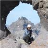
Almost at the top, we got our final surprise, which had not been mentioned in any of my advance reading"an actual tunnel under an overhanging rock which we had to climb to reach the bench leading to the register and benchmark. Maybe there's a way around it, but I certainly didn't see it. Trishapajean coming up the tunnel:
The clouds still weren't gone, but we did have the clearest weather of the day for the 20 minutes or so we spent at the summit. We got there just about 10:30 am. Finally seeing the summit in person was amazing.
We signed the register, left only five days earlier and bearing about thirty names. Then we retraced our steps back to the top of the red gully and began scouting out the most efficient route over to Windom.
I'd read various estimates of how far down one has to go, but I think we ended descending only about 800 feet to where we had an easy shot at Windom's west ridge. We could see the large party of climbers coming down off the ridge as we made our way over. We picked our way across the tops of a couple of the few remaining snow fields, moving mostly on easy rocks. We gained the west ridge at the saddle between Windom and the small ridge point which separates it from Peak 18.
I got one decent shot of Sunlight on the way up.
Clouds were closing in, not breaking up by this time. We met two climbers coming down who said they were abandoning their summit attempt, fearing rain. We decided to press on, knowing that we didn't have very far to go. We found the route fairly well cairned. We also found it easy to stay near the ridge crest regardless of the exact route we took through the rocks. We also found the climbing relatively easy, after Sunlight.
About 2:00 pm we hit the summit under total cloud cover. It's just plain weird. We found the register canister hanging from a rock wall just under the high point, but empty, since its lid was missing. We replaced the register, improvised a temporary lid with a Ziploc bag and a rubber band, and placed the canister on the shelf above its attachment point, in hopes that this would help our temporary fix survive longer. The sooner some foresighted climber can get up there with a proper cap, the better.
Since we couldn't see a thing, and it was after noon, we headed down fairly quickly.We hadn't gotten very far when it did indeed begin to rain. Fortunately, it was fairly gentle, and there was no thunder or lightning, and only lasted about fifteen minutes. This happened a couple more times on the way down.
We actually met one other person coming up! He said he had climbed Eolus that morning, and just needed Windom to finish the basin. We wished him luck.
After a fairly uneventful hike down, we made it back to camp about 5:30 pm. And then, as if to mock us, the skies mostly cleared, and we had warm sunshine at the end of our day!
The next day's adventure is covered in a separate report.
Thumbnails for uploaded photos (click to open slideshow):
Hey, Joey; nice to hear from you! Strangely, we only saw a grand total of 3 goats on the whole trip. Maybe the weather didn‘t agree with them! Yes, I did the summit block; it‘s 99% psychological but I was glad the rock was dry. (The picture is in Trisha‘s camera, which I haven‘t downloaded yet.) Many campsites were already taken, but there was no real problem...of course, that was mid-week. There are some more photos on my picasaweb album, but, in my haste, I forgot to put a link in the TR. I‘ll include it in part 2, which covers our odd adventure on Friday.
Adventurgal: Good luck! I hope this helps. It looks like bureaucratic inertia may just spare us all any inconvenience with the bridge after all. Otherwise, it‘s an extra 7 miles each way! You‘d better expect lots of company there over a holiday weekend, though.
How long and hard is the hike in? I was toying with the idea of starting from Silverton. I think the train drops you off at 3:30 or something close to that.
Kzar--It‘s about 7 miles with 3,000 ft. of elevation gain from the train stop to the camping area. You can hike a bit farther if you want a start closer to the peaks, but not much farther. The trail is well-traveled and clear, so it‘s not too hard, aside from the significant net grade. It took us 3:50 going up and 2:40 coming down. The train from Silverton does indeed get to Needleton at 3:45 pm. However, the northbound train, coming from Durango, drops you off at 11:30 am, which is why that‘s the one most hikers take. I have read that one advantage of starting from Silverton is that you can find free parking for your vehicle, which isn‘t available in Durango.
Caution: The information contained in this report may not be accurate and should not be the only resource used in preparation for your climb. Failure to have the necessary experience, physical conditioning, supplies or equipment can result in injury or death. 14ers.com and the author(s) of this report provide no warranties, either express or implied, that the information provided is accurate or reliable. By using the information provided, you agree to indemnify and hold harmless 14ers.com and the report author(s) with respect to any claims and demands against them, including any attorney fees and expenses. Please read the 14ers.com Safety and Disclaimer pages for more information.
Please respect private property: 14ers.com supports the rights of private landowners to determine how and by whom their land will be used. In Colorado, it is your responsibility to determine if land is private and to obtain the appropriate permission before entering the property.


")
")
")
")
")
")
")
")
")