Download Agreement, Release, and Acknowledgement of Risk:
You (the person requesting this file download) fully understand mountain climbing ("Activity") involves risks and dangers of serious bodily injury, including permanent disability, paralysis, and death ("Risks") and you fully accept and assume all such risks and all responsibility for losses, costs, and damages you incur as a result of your participation in this Activity.
You acknowledge that information in the file you have chosen to download may not be accurate and may contain errors. You agree to assume all risks when using this information and agree to release and discharge 14ers.com, 14ers Inc. and the author(s) of such information (collectively, the "Released Parties").
You hereby discharge the Released Parties from all damages, actions, claims and liabilities of any nature, specifically including, but not limited to, damages, actions, claims and liabilities arising from or related to the negligence of the Released Parties. You further agree to indemnify, hold harmless and defend 14ers.com, 14ers Inc. and each of the other Released Parties from and against any loss, damage, liability and expense, including costs and attorney fees, incurred by 14ers.com, 14ers Inc. or any of the other Released Parties as a result of you using information provided on the 14ers.com or 14ers Inc. websites.
You have read this agreement, fully understand its terms and intend it to be a complete and unconditional release of all liability to the greatest extent allowed by law and agree that if any portion of this agreement is held to be invalid the balance, notwithstanding, shall continue in full force and effect.
By clicking "OK" you agree to these terms. If you DO NOT agree, click "Cancel"...
Missouri Mountain
8/9/08
Northwest Ridge
Trailhead - 7:15 am
Summit - 11:00 am
Trailhead - 2:00 pm
I found this to be an enjoyable hike, not as tiring as expected, but the summit ridge was a bit challenging in places, due to the mud.
Fellow 14ers.com member Don Eberl and I both have done Belford/Oxford, but wanted to come back and attempt Missouri. I was out of town all week and didn't have a good feel for the weather, but we figured to give it a shot.
We left Denver at about 4:45am and arrived at the trailhead right about 7am. It was fairly cloudy on the drive over; I would have guessed we would be rained out and wondered if we would even step out of the car.
The hike up into Missouri gulch was uneventful, most people were taking the Belford trail, but we pressed on into the gulch. The trail through the gulch is very easy up to the sign, and turn off for Missouri Mountain.
Shot of Missouri Mountain with fog/clouds near the top. This is what we looked at to the summit.
From a bit up the trail to the saddle, looking up at the grassy slopes.
From the intersection up to the saddle was strenuous, but wasn't that bad. The trail actually winds its way up to the right of the photo, and traverses back across the face of the point on the right, crossing the grass slope, and then switching back on the rocks on the left. The trail is solid, with plenty of rock steps, making the segment up to the saddle quicker and easier than expected.
From the saddle, looking up at point 13,930.
Looking back toward the saddle from the point
Once you get around point 13,930, you can again see the summit of Missouri farther down the ridge. To me it was a bit farther than expected.
Looking down the ridge at Missouri
The ridge walk for the first section was easy. It was fun peeking down into the couloirs.
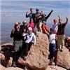
Shot of folks on the ridge and on the summit. Note the small hump to the left of the hikers in the center of the photo.
At a point closer to the summit, the first of the significant rock towers along the ridge presents a choice. You can either descend a dirt filled gully to the right and bypass the tower, or go over the top. We descended on the ascent and went over the tower on the return. For the smaller tower, I recommend going over the top. It was solid, and not very difficult.
The descent down and to the right
The smaller rock tower
We didn't try the second one, so I have no information on that. We bypassed it on the west side.
After the two rock towers, we were up a short slope and on the summit.
Looking down into Missouri Gulch
Looking back along the ridge, with a hiker left of center bypassing the rock towers on the west. She is climbing the dirt gully back to the ridge.
We didn't stay on the summit long due to the weather. As we were walking back along the ridge past the rock towers, we heard some thunder over near Huron, and picked up our pace to get below the saddle.
Looking west toward Huron
We made good time back down into the gulch. At that point, the clouds broke a bit and we took some shots of the flowers remaining in the gulch.
The attempt at being artistic
Looking back at Missouri
We took our time getting back to the trailhead. We both enjoyed being in the gulch above tree line. If we continue to attempt new 14ers, it may be a while until we come back, and we weren't anxious to leave. We chatted with a few other hikers and eventually made it back to the car.
Given the weather, both of us felt fortunate to get to the top (and back) of Missouri and felt that the enjoyable, dry, and safe hike was a nice gift for the weekend.
Thumbnails for uploaded photos (click to open slideshow):
I passed you yesterday (I was hiking alone) when you and your friend were coming down the 1st rock tower to the dirt gully near the summit. I am glad the weather held out for the day. The fog/low clouds gave the hike an interesting ambiance.
Jodi
Caution: The information contained in this report may not be accurate and should not be the only resource used in preparation for your climb. Failure to have the necessary experience, physical conditioning, supplies or equipment can result in injury or death. 14ers.com and the author(s) of this report provide no warranties, either express or implied, that the information provided is accurate or reliable. By using the information provided, you agree to indemnify and hold harmless 14ers.com and the report author(s) with respect to any claims and demands against them, including any attorney fees and expenses. Please read the 14ers.com Safety and Disclaimer pages for more information.
Please respect private property: 14ers.com supports the rights of private landowners to determine how and by whom their land will be used. In Colorado, it is your responsibility to determine if land is private and to obtain the appropriate permission before entering the property.


")
")
")
")
")
")
")
")
")
")
")
")
")