Download Agreement, Release, and Acknowledgement of Risk:
You (the person requesting this file download) fully understand mountain climbing ("Activity") involves risks and dangers of serious bodily injury, including permanent disability, paralysis, and death ("Risks") and you fully accept and assume all such risks and all responsibility for losses, costs, and damages you incur as a result of your participation in this Activity.
You acknowledge that information in the file you have chosen to download may not be accurate and may contain errors. You agree to assume all risks when using this information and agree to release and discharge 14ers.com, 14ers Inc. and the author(s) of such information (collectively, the "Released Parties").
You hereby discharge the Released Parties from all damages, actions, claims and liabilities of any nature, specifically including, but not limited to, damages, actions, claims and liabilities arising from or related to the negligence of the Released Parties. You further agree to indemnify, hold harmless and defend 14ers.com, 14ers Inc. and each of the other Released Parties from and against any loss, damage, liability and expense, including costs and attorney fees, incurred by 14ers.com, 14ers Inc. or any of the other Released Parties as a result of you using information provided on the 14ers.com or 14ers Inc. websites.
You have read this agreement, fully understand its terms and intend it to be a complete and unconditional release of all liability to the greatest extent allowed by law and agree that if any portion of this agreement is held to be invalid the balance, notwithstanding, shall continue in full force and effect.
By clicking "OK" you agree to these terms. If you DO NOT agree, click "Cancel"...
Left Denver Friday around 3PM with psycholoco (Mike), Summer, and Jackie Brown to meet Tomas and Coda in Carbondale. The full moon started to rise over the Elks as we reached Marble, and the views from the upper road on the way in were pretty amazing.
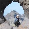
This is your tour guide Summer. Thanks Summer for taking the pics!
Let's go hiking. Left from Crystal Trailhead at 7 (we were slack).
The place was lush!
Above Geneva Lake (coming up to Little Gem Lake) our route came into view and, uh-oh, there was snow in all the gullies. We are supposed to climb the Y-shaped gully on the left.
I had not planned for this contingency by bringing crampons or ice axe (none of us had). So, we proceeded up to the grass patch to the left of the gully to see how it would go.
Looking back down on where we had come from the base of the gully.
We stayed left of the gully from here to the summit. The rock was sloper and loose all the way. Not exactly my idea of a good time! We spread out and mechanically scrambled up the 2,000 vertical ft without incident. I'm sure the easy path was just under the snow to our right. And it looks like it will be a good snow climb for a couple more weeks. On the ascent, we stayed a bit more to the left, where the rock was steeper but more solid. I'm no expert, but it did not seem like much class 2 to me- more like Class 3 most of the way we were going. I caught the rock rib in the center of where the snowfield splits and stayed close to the main snowfield all the way the the ridge just north of the summit. My companions, to varying degrees, gained the ridge above and to the left, which took them onto more steep, loose, and complicated terrain, which I believe only psycholoco could enjoy. Once on the North Ridge it was a thrilling and exposed (yet solid!) scramble to the top. That's Capitol in the background.
Tomas on top of the world.
Huddled for lunch in the small piece of shade.
Going down, we bypassed the North Ridge altogether, and headed west 50 yds or so from the summit to where you could enter the gully in a class 2 fashion. psycholoco (Mike) stands here above the S ridge- he is about to head North and enter the gully. The distance back to the trucks, where Jackie and Coda await our return, is clear: as far down as you can see.
Tomas had almost-mountaineering boots, and was able to kick step all the way down the snowfield, where he sat and watched the rest of us crab-walk down the face. The snow was far too steep and firm to safely glissade, in my opinion. Our perspective was improved, however, and we tended to stay closer to the gully on less steep but more gravelly terrain. The descent was easier than I had expected based on what we had gone up.
We arrived back at the trucks with sore feet but a pretty good sense of accomplishment. About 5 hours up and 4 down. The West Face was steep and exposed, and gave you a real sense of being "out there" in the air. It was sort of a unique vibe compared to every other 14er I've done. For this reason, it is a top-5 favorite so far.
Thumbnails for uploaded photos (click to open slideshow):
You could def summit in 4 hours or less if you are fast. We did a lot of route finding. As you pass Geneva Lake, stay left and up the hill. A sign that points to ”site 4” is actually your trail. We placed a small cairn.
The weather was perfect, so we took our time routefinding up the the face as well. I wanted to keep mental notes on where to climb down. You had to test every hold, too, so it took a while.
if you have anymore photos of the downclimbing you did, I would love to see more of what it looks like. I am fine going up, just not down on loose rock, esp loose class 3 crappy rock.
Lo siento no hay mas photos. If you wait for the snow to melt, and route-find better than we did, you could probably keep it at Class 2 most of the way. I think the intended route is more in the gully in some places than we went or could go because of the snow. And on the down climb, we were able to route-find better, and stayed closer to the gully, and it was more like Class 2 mostly. I spent a lot of time on my hands and/or butt scooting down stuff, and my good gloves are my new favorite piece of gear. Take care and take your time and you can do it!
Caution: The information contained in this report may not be accurate and should not be the only resource used in preparation for your climb. Failure to have the necessary experience, physical conditioning, supplies or equipment can result in injury or death. 14ers.com and the author(s) of this report provide no warranties, either express or implied, that the information provided is accurate or reliable. By using the information provided, you agree to indemnify and hold harmless 14ers.com and the report author(s) with respect to any claims and demands against them, including any attorney fees and expenses. Please read the 14ers.com Safety and Disclaimer pages for more information.
Please respect private property: 14ers.com supports the rights of private landowners to determine how and by whom their land will be used. In Colorado, it is your responsibility to determine if land is private and to obtain the appropriate permission before entering the property.


")
")
")
")
")
")
")
")
")
")
")