Download Agreement, Release, and Acknowledgement of Risk:
You (the person requesting this file download) fully understand mountain climbing ("Activity") involves risks and dangers of serious bodily injury, including permanent disability, paralysis, and death ("Risks") and you fully accept and assume all such risks and all responsibility for losses, costs, and damages you incur as a result of your participation in this Activity.
You acknowledge that information in the file you have chosen to download may not be accurate and may contain errors. You agree to assume all risks when using this information and agree to release and discharge 14ers.com, 14ers Inc. and the author(s) of such information (collectively, the "Released Parties").
You hereby discharge the Released Parties from all damages, actions, claims and liabilities of any nature, specifically including, but not limited to, damages, actions, claims and liabilities arising from or related to the negligence of the Released Parties. You further agree to indemnify, hold harmless and defend 14ers.com, 14ers Inc. and each of the other Released Parties from and against any loss, damage, liability and expense, including costs and attorney fees, incurred by 14ers.com, 14ers Inc. or any of the other Released Parties as a result of you using information provided on the 14ers.com or 14ers Inc. websites.
You have read this agreement, fully understand its terms and intend it to be a complete and unconditional release of all liability to the greatest extent allowed by law and agree that if any portion of this agreement is held to be invalid the balance, notwithstanding, shall continue in full force and effect.
By clicking "OK" you agree to these terms. If you DO NOT agree, click "Cancel"...
Crestone Needle (14197) June 28, 2008 Route: South Face, East Gulley Round Trip: 6.25 miles, 7.5 hours Elevation Gain: 3300 ft. Hikers: KirkT
My plan was to hike Crestone Needle on Saturday solo, and then head down to Lindsey to meet a handful of 14er.com members coming up from Culebra for a hike on Sunday. After working out my details I left the city around 2:30am Saturday morning and headed towards Westcliffe. I arrived at the lower South Colony trailhead at 5am. I continued up the newly improved road all the way to the upper trailhead. I arrived there at 6am. For those wanting to know the conditions of the road...I drove my Ford Escape all the way to the upper trailhead without much incident. The road has been greatly improved since last year. Still not a highway, but greatly improved nonetheless.
After gearing up and lubing with sunscreen, I was off at around 6:15. The first part of the hike is covered with alot of snow. It is however easy to navigate and well packed down from all the traffic. I made pretty quick time and was at Colony Lake in about 40 minutes. There were several tents scattered all around the lakes. The snow around the lakes is melted out pretty good. There are alot of great camping spots to be had right now. After loosing the trail and bushwacking for about 20 minutes, I finally found the trail again and headed up Broken Hand Pass. This part of the trail is still covered with alot of snow. I was able to climb it carefully with my boots and trekking poles. I met up with a group of 4 who were also attempting the Needle. They were not so experienced on snow and were moving at a fairly slow pace which was ok with me. Better to hike slow with a group than fast and lonely I always say.
We made pretty good time up to the bottom of the East Gulley. We started up the Gulley in single file with myself leading the way. The plan was to climb to around 13600ft and traverse over to the West Gulley to the summit as per Bill's descriptions. The weather was incredible with sunshine and clear skies. You could see for miles. I knew however, that the forecast was for severe storms later in the day. Knowing this, I kept up a fair but steady pace up the mountain and up the Gulley. The group I was with consisted of two couples. The gals in this group were not overly comfortable with this type of hiking and were beginning to slow considerably. They decided to wait at about 13400 and we continued up towards the summit. We arrived at the summit at 10:15.
I snapped a few pictures from the summit and started back down. We started back down the West Gulley in quick fashion. There were a few clouds beginning to form to the North and West. I knew we were on borrowed time according to the previous days forecast. We continued on down the Gulley and found the cross over back to the East Gulley. We made it back to where the girls were waiting and continued on down to the bottom of the Gulley.
I reached the lower portion of the pass in quick fashion. The clouds were beginning to build rapidly and thunder could be heard in the distance. I grabbed my axe and glissaded down about 250 ft. to where the cross over to the Colony Lakes started. As I hiked a quick pace back to the trailhead. I made it back to the trailhead a 1:40. I ate my sandwich and headed down South Colony road and started my trip down to Mt. Lindsey where I was going to meet some fellow hikers for a climb on Sunday.
First light on the Needle.
Crestone Needle trail split.
Broken Hand Pass.
The South Face of the Needle.
Looking up the class 4 section of the East Gulley.
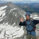
Crestone Peak from the summit.
Blanca group to the south.
Incredible clouds forming over Humboldt.
South Colony Lakes down below.
Treking down the West Gulley.
Needle on the way out.
Thumbnails for uploaded photos (click to open slideshow):
Thanks for sharing all of this good info. Looked like you had a beautiful morning. What were the snow/water conditions in the East and West gullies on the Needle? I‘m heading up there with a group in 2 weeks and am planning my trip.
Good point on checking the weather forecast before you go - and planning accordingly (extra early descent). Looks like the weather was getting ready to take a crap up there... thanks for the nice report, and pictures, too.
I have been waiting for some beta on the Crestones. I appreciate the TR as always.
Caution: The information contained in this report may not be accurate and should not be the only resource used in preparation for your climb. Failure to have the necessary experience, physical conditioning, supplies or equipment can result in injury or death. 14ers.com and the author(s) of this report provide no warranties, either express or implied, that the information provided is accurate or reliable. By using the information provided, you agree to indemnify and hold harmless 14ers.com and the report author(s) with respect to any claims and demands against them, including any attorney fees and expenses. Please read the 14ers.com Safety and Disclaimer pages for more information.
Please respect private property: 14ers.com supports the rights of private landowners to determine how and by whom their land will be used. In Colorado, it is your responsibility to determine if land is private and to obtain the appropriate permission before entering the property.


")
")
")
")
")
")
")
")
")
")
")