Download Agreement, Release, and Acknowledgement of Risk:
You (the person requesting this file download) fully understand mountain climbing ("Activity") involves risks and dangers of serious bodily injury, including permanent disability, paralysis, and death ("Risks") and you fully accept and assume all such risks and all responsibility for losses, costs, and damages you incur as a result of your participation in this Activity.
You acknowledge that information in the file you have chosen to download may not be accurate and may contain errors. You agree to assume all risks when using this information and agree to release and discharge 14ers.com, 14ers Inc. and the author(s) of such information (collectively, the "Released Parties").
You hereby discharge the Released Parties from all damages, actions, claims and liabilities of any nature, specifically including, but not limited to, damages, actions, claims and liabilities arising from or related to the negligence of the Released Parties. You further agree to indemnify, hold harmless and defend 14ers.com, 14ers Inc. and each of the other Released Parties from and against any loss, damage, liability and expense, including costs and attorney fees, incurred by 14ers.com, 14ers Inc. or any of the other Released Parties as a result of you using information provided on the 14ers.com or 14ers Inc. websites.
You have read this agreement, fully understand its terms and intend it to be a complete and unconditional release of all liability to the greatest extent allowed by law and agree that if any portion of this agreement is held to be invalid the balance, notwithstanding, shall continue in full force and effect.
By clicking "OK" you agree to these terms. If you DO NOT agree, click "Cancel"...
Mount Antero 14,269 Feet (10th highest in Colorado)
West Slopes Route
Baldwin Gulch Jeep Road Second Creek Crossing (11,100 Feet)
Grade II, Class 2
June 22nd, 2008
About 8 Miles Roundtrip
Elevation Gained: Approximately 3,169 Feet
Greenhouseguy (Brian), Slow Moving Fun Seeker (Jay), and RockFarmer (Zach)
On the Rocks
Mount Antero was named for a peaceful member of the Uintah band of Ute Indians, Chief Antero. His name translates roughly to "Graceful Walker." The names of the other fourteeners in Mt. Antero's group (Mt. Shavano and Tabeguache Peak) also have Ute origins. Shavano was a Ute Indian chief, and Tabeguache was the name of a band of Utes. Mount Antero is widely known for its mineral wealth; it has one of the highest concentrations of aquamarine crystals in the world. Topaz and smoky quartz crystals are also commonly found on Antero's slopes. There are several active mining claims in the area.
My first attempt on Mt. Antero ended in disaster. My Jeep died about � mile up the Baldwin Gulch Jeep Road. I was able to roll back into a turnout, but I was unable to call for help because there was no cell phone reception. Fourteeners members USAKeller and Comin2getcha helped us turn around, and we coasted all the way down to the hot springs. My wife brought tools and parts all the way from Brighton, and I was able to patch the Jeep back together and drive home. The auto parts were cheap compared to the gasoline used in the recovery effort and the steak dinners for my family members who helped me. A prompt rematch was in order.
Jay and I rode down from Denver together, and we met Zach at the trailhead. He had driven up from Colorado Springs on Friday night and enjoyed the deluxe accommodations in the back of his Jeep. We loaded his gear in the back of my vehicle and started up the fabled Baldwin Gulch Jeep Road.
The lower part of the road was extremely rocky. My Jeep Cherokee with 30" tires had plenty of clearance, but low-clearance vehicles would not do well on this road without an exceptional driver. Picking lines through the rocks was tedious and nerve-wracking. After about 2.5 miles, we reached the Baldwin Creek crossing. Many drivers choose to stop at the creek, but fording the creek is easier than it appears. The creek bed is level, both banks are fairly level, and the water is only about a foot deep. It would be difficult to cross the creek on foot without getting soggy. We continued about 0.2 miles to a second creek crossing, an parked on the far side of the creek at about 11,100 feet. There were several good campsites in the area.
Gearing up just past the second creek crossing
Aquamarines are not the only gems on Mt. Antero. The wildflowers were quite showy, and I noticed some alpine wallflowers and red columbine before we even got started.
Red columbine (Aquilegiaelegantula) near the second creek crossing
The road above the second creek crossing was much smoother than the lower part of the road. There were wet spots and small patches of snow, but hiking on the road was refreshingly easy.
The Baldwin Gulch Jeep Road at about 11,200 feet
We passed a nice campsite at about 11,700 feet, just below treeline. The switchbacks heading up the west side of Pt. 13,800 were clearly visible.
Looking at Pt. 13,800 from the Jeep Road at 11,700 feet
Mt. Antero is not known as one of Colorado's most beautiful mountains, but the views became pretty impressive as we slowly gained altitude.
Looking back at the road from treeline (about 11,800 feet). The valley framed an incredible view in the background.
There are two gullies on the side of Pt. 13,800 that make excellent shortcuts when they are filled with snow. When the snow melts, the fragile tundra is susceptible to erosion from foot traffic. The snow in these gullies is rapidly melting, but there were still a couple of snowy sections that would make useful shortcuts between switchbacks. We stuck to the road on the ascent, but several other hikers used the gullies.
The first gully on Pt. 13,800's west side
At about 12,000 feet, the road started to switchback up the west side of Pt. 13,800. The road was clear and navigable up to about the third switchback; at this point, a short but impenetrable snow bank blocked the road.
The switchbacks on Pt. 13,800's west side. Mt. Antero looms in the distance.
Tight bends in the switchbacks make this a difficult road for long-wheelbase vehicles. Even under ideal conditions, this is not a road for the faint of heart. The road goes up and over a pass to Brown Lake; this would be an interesting place to start the Northeast Slopes route on Tabeguache Peak.
Tight switchback on Pt. 13,800
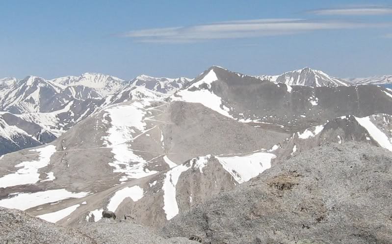
One of the most incredible-looking peaks in the area is the unofficially-named "North Carbonate." Its north and east ridges look like they would present a healthy challenge.
"North Carbonate" (13,870 feet) seen from the Baldwin Gulch Jeep Road
The most common alpine wildflower was the sky pilot (Polemoniumviscosum). Its blue flowers are spectacular, but one should admire them from a distance; the foliage has a skunky scent!
Sky Pilot (Polemoniumviscosum) along the Jeep road
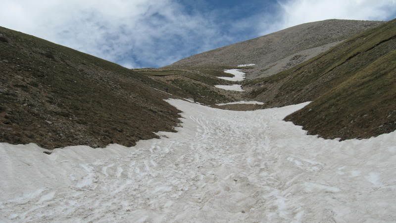
As was previously mentioned, the snow gullies are rapidly melting out. The image below shows the amount of snow remaining in the longest gully on Pt. 13,800.
Snow gully on Pt. 13,800
We took a brief detour from the Jeep road at about 12,950 feet. A narrow trail ascends the side of a ridge, while the road loops around the end of the ridge. This shortcut is a real timesaver.
Trail on Pt. 13,800's southwest ridge
We picked up the Jeep road again on the south side of the ridge, and headed east. I had checked out this part of the road from Mt. Shavano's summit on May 31st, when the road was covered with snow. The snow had melted, and we made good time on the road.
Mt. Antero and the switchbacks on the south side of Pt. 13,800 as seen from Mt. Shavano on May 31st, 2008
The road led to the south side of Pt. 13,800, where it switchbacked about 500 feet to a pass near the summit. This subpeak is where some of the gem mining activity takes place.
Mt. Antero's summit viewed from the pass on Pt. 13,800
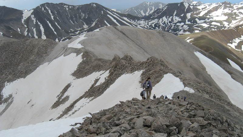
The pass on Pt. 13,800 topped out at 13,730 feet. A gnarly ridge stretched out before us, with a steep pile of talus behind it. The spine of the ridge reminded me of a huge dinosaur. There were quite a few hikers ahead of us, and they were bunching up as the terrain became more difficult.
Mt. Antero's south ridge and summit cone viewed from the trail at 13,730 feet
There was an easy trail along the ridge, but we had to scramble around a couple of snow-covered sections. The weather was fantastic, but we were exposed to a chilly breeze on the ridge. The 0.3-mile ridge led to the steep and rocky summit cone.
Mt. Antero's approximately 375-foot summit cone
I dreaded hiking up the steep summit cone, but it wound up being far easier than it looked. An easy trail zigzagged through the talus towards the summit. A huge snowfield blocked the trail as it angled across the south face to the northeast, but another obvious trail stuck to the ridge and led straight to the summit. A group of more than a dozen people were lounging in the sun on the summit when we arrived.
Mt. Antero's busy summit
The summit was smaller than many that I've visited, and it was a little bit crowded. We enjoyed views of the Collegiate Peaks, the Elk Range, and the Sangres. Mt. Shavano and Tabeguache Peak were the nearest fourteeners.
Mt Shavano (left) and Tabeguache Peak (right)
Mt. Princeton was the closest fourteener to the north.
The southwest side of Mt. Princeton
To the north beyond Mt. Princeton, I could see Mt. Yale, Mt. Columbia, and Mt. Harvard.
Several of the Collegiate Peaks seen from Mt. Antero's summit
Summit shot (L to R): Greenhouseguy (blue), SlowMovingFunSeeker (red), and RockFarmer (orange)
Moments after I commented about the fine weather on the summit, a huge black cloud moved in. There was no thunder or lightning, but the entire summit cleared out in about 30 seconds. Nobody wanted to be on that ridge if a storm moved in!
Hikers descending Mt. Antero's south ridge
The dark cloud passed, and we continued downward at a leisurely pace. Like many hikers, I was hoping to find some sort of valuable gemstone. I found a 3/8" flake of green fluorite, but did not find anything of value. Flashes of blue kept catching my eye, but it was just alpine forget-me-nots.
Alpine forget-me-nots (Eritrichiumaretioides) at about 13,000 feet
I was anxious to catch a couple of glissades on the way down, so I scouted out a steep section of the snow gully and made it most of the way from one switchback to another. I waited for Jay and Zach to come down the road, then I took another much longer glissade. The snow was not of the best quality, and it was suncupped and full of bootprints. I managed to find every bump and protruding rock on the way down, and soaked myself in the process. It was, however, a much faster way down the mountain.
Looking back up the snow-filled gully
We arrived back at the Jeep and took a few minutes to gear down. We changed into more comfortable shoes, hydrated, and started back down that dreadful road. The hiking was pretty mellow, and I was not particularly tired until I started to drive. I missed most of the big rocks, but even the small rocks jarred my bones. We met several vehicles on the road, and had to back up to the nearest turnout to allow them to pass. I found the driving to be more exhausting than the hiking.
Link to video of the Baldwin Creek crossing on the way down
Mt. Antero is not one of the lovelier peaks, but it is a great beginner or training hike. The route is easy to follow, non-technical, and the only steep section is fairly short. The summit views were rewarding, and made the hike worthwhile. The road to the second creek crossing would probably overwhelm many inexperienced drivers. Hiking from the lower 2WD trailhead would add significant distance to the hike, but it might be preferable to the brain and vehicle damage resulting from driving on the Baldwin Gulch Jeep Road. I won't be eating Rocky Road ice cream for a while, that's for sure.
Thumbnails for uploaded photos (click to open slideshow):
Nice trip report. Finally found it by the way Can‘t wait to see the one on Princeton.
Caution: The information contained in this report may not be accurate and should not be the only resource used in preparation for your climb. Failure to have the necessary experience, physical conditioning, supplies or equipment can result in injury or death. 14ers.com and the author(s) of this report provide no warranties, either express or implied, that the information provided is accurate or reliable. By using the information provided, you agree to indemnify and hold harmless 14ers.com and the report author(s) with respect to any claims and demands against them, including any attorney fees and expenses. Please read the 14ers.com Safety and Disclaimer pages for more information.
Please respect private property: 14ers.com supports the rights of private landowners to determine how and by whom their land will be used. In Colorado, it is your responsibility to determine if land is private and to obtain the appropriate permission before entering the property.


")
")
")
")
")
")
")
")
")
")
")
")
")
")
")
")
")
")
")
")