Download Agreement, Release, and Acknowledgement of Risk:
You (the person requesting this file download) fully understand mountain climbing ("Activity") involves risks and dangers of serious bodily injury, including permanent disability, paralysis, and death ("Risks") and you fully accept and assume all such risks and all responsibility for losses, costs, and damages you incur as a result of your participation in this Activity.
You acknowledge that information in the file you have chosen to download may not be accurate and may contain errors. You agree to assume all risks when using this information and agree to release and discharge 14ers.com, 14ers Inc. and the author(s) of such information (collectively, the "Released Parties").
You hereby discharge the Released Parties from all damages, actions, claims and liabilities of any nature, specifically including, but not limited to, damages, actions, claims and liabilities arising from or related to the negligence of the Released Parties. You further agree to indemnify, hold harmless and defend 14ers.com, 14ers Inc. and each of the other Released Parties from and against any loss, damage, liability and expense, including costs and attorney fees, incurred by 14ers.com, 14ers Inc. or any of the other Released Parties as a result of you using information provided on the 14ers.com or 14ers Inc. websites.
You have read this agreement, fully understand its terms and intend it to be a complete and unconditional release of all liability to the greatest extent allowed by law and agree that if any portion of this agreement is held to be invalid the balance, notwithstanding, shall continue in full force and effect.
By clicking "OK" you agree to these terms. If you DO NOT agree, click "Cancel"...
Route: Wilson Peak, NW face, Silver Pick Basin
Elevation Gained: ~4,000-ft
Roundtrip Mileage: ~8-mi
Time: 10-hr
Group: Scott (scotthsu) & Amy (Nice Axe!)
Andy & Sarah (CincyBearcats)
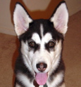
Nina (our pawed companion)
(Though Sarah and I have been working on our 14er checklist for a couple of years now, this is the first trip we've done that's FINALLY been worthy of a trip report. However, I must admit that, by writing this trip report, I am merely stealing Scott and Amy's thunder. This route was well beyond our comfort range, and we never would have been able to do the final push to the summit without their guidance. Their coaching inspired confidence when it was all but gone.)
After dinner in Telluride, we drove up the road towards the Silver Pick Trailhead on Saturday evening. We were stopped by the snow around 9,700-ft, which was just over half a mile shy of the summer trailhead. Before we retired for the night, we were treated to a spectacular sunset.
(Wilson Peak doused in alpenglow)
The following morning, we started skinning up the remainder of the Silver Pick road around 5:15 AM. About an hour later we arrived at the summer trailhead, and we reached the second gate on the road around 6:45 AM.
(Coming out of the trees into Silver Pick Basin)
Once we reached the private property line, we left the road and veered east up onto the hillside in an effort to avoid trespassing. We then traversed along the hillside until we fell into stride with Big Bear Creek. We then continued farther up into the basin, and Wilson Peak quickly came into view. From this point, we picked our way safely through the avalanche terrain up into the successive bowls below the face. With careful route-finding and switch-backing, we were able to stay on gentle slope angles that our skins could handle.
(Our first glimpse of the NW face)
(Looking back on the NW face after our descent)
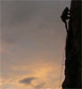
After picking our way up through the highest bowl, we worked our way across the bench and onto the base of the NW face. At this point, we switched from skins to crampons. There was over a foot of fresh wintry powder on the lower slopes of the face from the recent storm. The fresh snow had little cohesion, reducing the potential for a slab, and the bed surface was stable. Scott took the lead and laid down an amazing snow staircase. Only an escalator could have beat his boot pack. The slope on the open face was sustained around 40-deg.
(The end of the skinning)
(After our descent, looking back up the boot line towards the summit gully)
(Scott takes a well deserved break to pose with Sarah and Nina. The summit gully is just over Sarah's left shoulder.)
Once we reached the top of the open face, we entered a deep, narrow gully that led to the summit. Near the entrance, the slope steepened to 45-deg. The wintry powder slowly transitioned to a hardened crust that could be penetrated only by the front points of our crampons. Amy took the reins at this point and led us to the end of the snow line. The slope continued to steepen a few more degrees until, much to our dismay, the snow ended at a rocky face a few hundred feet below the summit. We conceded that a proper summit ski descent would have to wait for another day. Instead, we faced a few spicey moves to get off the snow and onto the summit ridge. The climbing was sustained class 3 for a few dozen feet, but it wasn't much fun with ski boots. A few sweaty palms and knocking knees later, we found ourselves on the summit ridge just a few yards from the summit proper. We were standing on the top of our world by 12:30 PM.
(Andy and Nina take a breather while perched just above the entrance to the summit gully.)
(Amy leads the way up the summit gully, and Sarah follows suit. The headwall is just to the right of Amy at the highest point in the snow.)
(The end of the line.)
(Andy approaches the headwall of the summit gully)
(Looking down the lower portion of the headwall, Nina ponders the advantages of four-paw-drive over the opposable thumb.)
(Amy makes her way off the headwall from the gully and onto the summit ridge)
(Nina attentively awaits as Andy and Sarah push through the final few steps to the summit)
(Scott and Amy are all smiles on a fantabulous summit.)
(Andy and Sarah pose on the summit while Nina has a rare camera-shy moment.)
(Mt. Wilson and El Diente draped in white glory)
Although a few choice words resounded from the steep face on a few occasions, the descent from the summit back to the opening of the summit gully passed without incident. With the rocky, icy down-climb behind us, I issued a bellowing sigh of relief. From there, we got down to business: sucking down as much wintry powder as we could hound on a gorgeous May day. After a short break in the shade along the road to cool off, we arrived back at the car at 3:15 PM, capping off a splendid ski descent.
(Scott beats the slope into submission with all the tele style of a rock star.)
(Amy opens the throttle and lays down her line.)
(Andy, Nina, Sarah, and Amy tear up the spring corn in the lower reaches of Silver Pick Basin)
Thanks again to Scott and Amy for taking us to the next level in our 14er quest. They were patient and encouraging every step of the way.
Thumbnails for uploaded photos (click to open slideshow):
first shot of the peak in the sunset, I love it from that angle. I‘d yell on the summit with joy as well if I was up there, great report and a perfect day.
I peered down the NE face but couldn‘t see very far down. There is continuous snow from the summit down at least a couple of lines within sight. If you want, either Andy or I could email you an 8 Mpixel shot of the NE face taken from the Silver Pick Rd. By zooming in, you can see that there may be one or two billygoating sections up high, but otherwise a continuous ski descent is probably in.
Awesome job all of you. Scott and Amy- good for you to help Andy and Sarah (and Nina) get to a higher level. I like the last photo of you guys skiing down together.
what andy forgot to mention is that the slope beat me into submission. lower down i had a tele-implosion and did a full-on ragdoll somersault, during which i remember seeing only my two skis and the clear blue sky
Your making me wish I brought my skies last year, looks like it was a great line! You definitely climbed more of the ridge than we did last year, which gully did you use to get to the summit? The one we used left us only 20 steps from the summit and it was all snow to the summit ridge, no rocky exit. I think your route was more to the right than ours? Just curious...
chicago transplant, yes, it looked like there were 2 other upper gullies just to climber‘s left of ours. but with the reduced snow, it wasn‘t obvious how to get into them, and they were pretty snow-free anyway. so we stayed in our (climber‘s right) gully, which required about 100 vertical ft. or so of class 3 rock scrambling in ski boots before we reached the location where you guys reached the summit ridge.
Thanks for the comments everyone. After being deemed a ”lurker” (at the time, I didn‘t even know what that was) on Uncompahgre by Caroline and David, it feels good to finally make a (albeit, small) contribution to the community. This is one of the few times that we‘ve strayed from the ”standard” summer route, for which a TR from me wouldn‘t stand up to Bill‘s terrific route descriptions.
Mike: It was very demoralizing for me when I saw that there wasn‘t enough snow to reach the summit. Since we were there a few weeks earlier than you guys were last year, we were confident that there would be plenty of snow, especially since it‘s be such a good snow year in CO. After pouring over your photos and ours, I‘m quite confident that we entered the same couloir. It just seems that you found an exit that wasn‘t available to us. I actually did a sketchy down-climb back through the top half of the couloir to see if we had missed your route, but there just wasn‘t enough snow for us to make a safe exit. Really, our only option was to climb the headwall at the very top.
I wonder why there was so much less snow in that gully for you guys this year, especially being earlier. Its good beta for anyone looking at this route this year, just goes to show that even in back to back good snow years there can be a lot of variation in conditions!
by the lack of snow. when scott mentioned you guys were headed that way i thought you‘d have pictures with snow loaded here and there. guess the winds have been doing a number up there!
nice job folks despite not getting that summit ski. there are worse things than having to climb wilson peak again for that accomplishment.
Wow- impressive! A huge congrats to you and Sarah on ”the next level.” Scary, yet exciting isn‘t it?!! Looks like your trip sure beats the crowded runs a weekend warrior endures at summit county ski resorts!
Great TR CincyBearcats! You guys rocked it and Nina‘s avalanche/backcountry travel training is coming along great! What a super-canine, she really hauls in the POW, and sporting a wide grin the whole time except for that hairy summit ridge move! Thanks for letting us share your 40th peak! Way to push it!
it was a fun day on a beautiful mountain with you guys. what a great summit, the kind that makes you holler at the top of your lungs with joy. you guys did great! hopefully we'll be able to join you on a few more on your way to finishing the 14ers. special thanks to shanahan96 for PMing me some route beta for the upper gully; I was amazed there was less snow compared to their Memorial weekend trip from last year! think snow 8)
Caution: The information contained in this report may not be accurate and should not be the only resource used in preparation for your climb. Failure to have the necessary experience, physical conditioning, supplies or equipment can result in injury or death. 14ers.com and the author(s) of this report provide no warranties, either express or implied, that the information provided is accurate or reliable. By using the information provided, you agree to indemnify and hold harmless 14ers.com and the report author(s) with respect to any claims and demands against them, including any attorney fees and expenses. Please read the 14ers.com Safety and Disclaimer pages for more information.
Please respect private property: 14ers.com supports the rights of private landowners to determine how and by whom their land will be used. In Colorado, it is your responsibility to determine if land is private and to obtain the appropriate permission before entering the property.


")
")
")
")
")
")
")
")
")
")
")
")
")
")
")
")
")
")
")
")