Download Agreement, Release, and Acknowledgement of Risk:
You (the person requesting this file download) fully understand mountain climbing ("Activity") involves risks and dangers of serious bodily injury, including permanent disability, paralysis, and death ("Risks") and you fully accept and assume all such risks and all responsibility for losses, costs, and damages you incur as a result of your participation in this Activity.
You acknowledge that information in the file you have chosen to download may not be accurate and may contain errors. You agree to assume all risks when using this information and agree to release and discharge 14ers.com, 14ers Inc. and the author(s) of such information (collectively, the "Released Parties").
You hereby discharge the Released Parties from all damages, actions, claims and liabilities of any nature, specifically including, but not limited to, damages, actions, claims and liabilities arising from or related to the negligence of the Released Parties. You further agree to indemnify, hold harmless and defend 14ers.com, 14ers Inc. and each of the other Released Parties from and against any loss, damage, liability and expense, including costs and attorney fees, incurred by 14ers.com, 14ers Inc. or any of the other Released Parties as a result of you using information provided on the 14ers.com or 14ers Inc. websites.
You have read this agreement, fully understand its terms and intend it to be a complete and unconditional release of all liability to the greatest extent allowed by law and agree that if any portion of this agreement is held to be invalid the balance, notwithstanding, shall continue in full force and effect.
By clicking "OK" you agree to these terms. If you DO NOT agree, click "Cancel"...
Route: East Face Trailhead: Cross Mountain TH at 10,000' Partner: Cynthia Adams Distance/Vertical/Time (RT): ~6.4 miles, ~4,800, 8.25 hours (with high camp at 11,800') Additional Stuff:
Introduction
Sometime back in October or November 2006 Cynthia had sent me an e-mail with her proposed winter peak climbing schedule. For all of the climbs but one I was either busy or not exactly excited about it. But one of her suggestions stuck out and intrigued me--Gladstone Peak, a high 13er in the San Juan Peaks. I had been next two it on three previous visits to the area to climb neighboring 14ers but had never had the time or opportunity to climb it. Without giving thought to logistics or route, I committed to the date--the weekend of February 9th. We'd figure out the details later.
Later came faster than expected and we still hadn't decided how to tackle the peak. Struggle with a long, likely crappy and illegal approach through Silver Pick Basin, check out the Sunshine Mesa trailhead or figure something else out. And then as luck would have it, Ken Nolan posted a trip report on 14erworld.com from his successful climb of Gladstone's east face in early January 2007! His route looked and sounded great and very doable. We planned to follow in his footsteps even if new snow and wind had literally obliterated the tracks. Because we hoped to climb the neighboring 14er, Wilson Peak, we'd setup a high camp just on the north side of the Cross Mountain-Lizardhead saddle.
Friday, February 9th
We awoke at 5:10am in our hotel room at the Rico Hotel. We had driven from New Mexico on Thursday night to arrive at the quaint hotel with "spartan" rooms. It was good enough for 5.5 hours of sleep. A short drive up the road got us to the Cross Mountain Trailhead by 6:30am. The trailhead area was plowed enough for 10 vehicles to park and was dry. By 7:00am we started off in warm conditions and had a nicely packed skin/snowshoe trail to follow through the trees all the way to the Cross-Lizardhead saddle. Our packs were heavy with comfort items but we figured it was such a short hike we might as well camp in relative style. Likely I frustrated Cynthia as I chose to use my splitboard snowboard for this trip rather than snowshoes and made quick time as she was forced to plod in snowshoes. But she didn't show any signs of being heavily slowed and kept a great pace all the way to our camp.
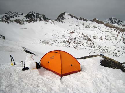
We chose to descend north off of the saddle for about 100 feet to a nice snow/rock outcropping in a shallow gully for our camp. Quickly we shoveled out a nice platform and setup camp by 11:00am. I even had a short bit of time to cut some snow blocks to give camp that nicely appointed feeling. We'd be there two nights, might as well make it nice!
Lodging for two for two nights with a view. No hot tub though.
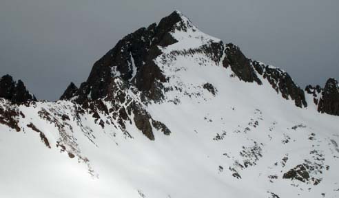
After camp was assembled we reconnoitered the planned route. All the obvious landmarks from Ken's report were visible and the line looked obvious. Hopefully we'd find nice consolidated snow over yonder. As Cynthia descended from camp down and across the upper basin towards Gladstone I assembled my snowboard and enjoyed a few hundred feet of turns into the basin. The snowpack was as I was expecting given the recent windy and warm conditions in the San Juans. It was nearly bullet proof and well consolidated. We were very encouraged by the stability of the snow. To be sure, though, we stuck to rocky ribs where we could as we climbed towards the prominent rock outcropping in the center of Gladstone's east face just below the major cliff band.
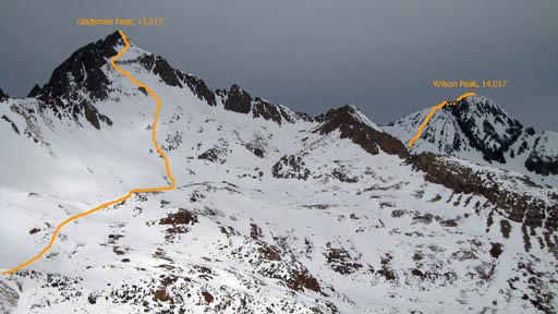
Photo showing our routes for both peaks for the weekend. The lower portion of the route on Wilson Peak is obscured here by Gladstone's east ridge.(/b:b8cb03221f)
As we approached the 12,500' level the terrain became steep enough and slick enough that the splitboard skins and snowshoes were no longer effective. We cached the board and shoes on a rock and donned the crampons. From there the snow was perfect styrofoam just ripe for kicking great steps at times but then would turn to a crusty surface with a few inches of sugary snow just below in other spots closer to the rock bands. We did our best to find the good snow and stick to it. Just below the major rock outcropping we spaced out and took turns ascending the steeper headwall to distribute the weight on the snowpack for safety's sake.
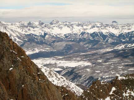
Ah, the view! Looking northeast towards the Telluride valley. Mount Sneffels can be clearly seen.
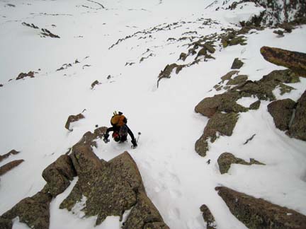
Once above the rock outcropping we had a great view of the cliff band and headed towards a farily obvious weakness in the left side. The climbing through this section was borderline 4th class but with the decent snow, it went with only a couple of grunt moves. We used the exposed rock for hand holds a couple of times as we climbed through it.
Cynthia climbing through the cliff band.
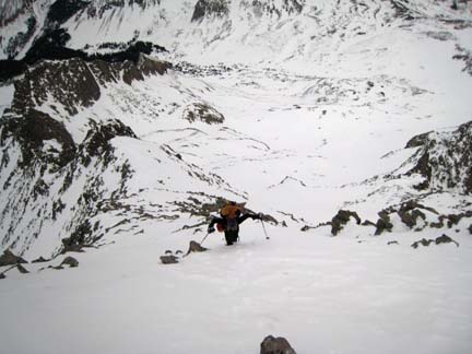
Once above the cliff band we had a foreshortened view of the small summit face and it looked so close. But my altimeter showed we still have at least a few hundred feet remaining. We gained the southeast ridge proper and wow, what a view! A dramatic drop to the south looking into the bowl on Mount Wilson's east face kept us well away from the corniced ridge as we kicked steps upwards. We even found a short section of Ken's previous tracks from a month ago along the ridge here. To gain the east ridge proper we climbed up a steep, shallow snow gully.
On the east ridge proper only ~100 vertical feet from the summit.
At 2:30pm we arrived at the summit! Conditions were amazing for February in the San Juans and I was in awe that we had actually reached the summit of this fine peak. The temperature was in the mid-20s and the wind was quite calm. In fact, I was wearing only a ball cap and sunglasses on my head and only a long-sleeved polypro shirt on my upper body and was very comfortable in that. The clouds had lifted on the surrounding peaks revealing a great view in all directions. The north ridge of Gladstone stretching towards Wilson Peak was quite dramatic. This also gave us a great opportunity to view the upper slopes of Wilson Peak's south face to plan our route for tomorrow!
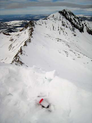
I got my shovel out and started digging for the summit register. I wasn't sure I'd find it but low and behold in only a couple of minutes I saw the red lid of the plastic peanut butter jar register that Ken had placed in September 2006!
Looking at the north ridge of Gladstone connecting to Wilson Peak.
With the exception of two other parties' entries in September, Ken's entry from January was the only other entry on the register. We felt quite lucky to be on the summit of Gladstone in February no doubt.
After the normal summit photos and about 20 minutes of summit time, it was time to descend. While I was pleased with the stability of snow on the ascent, I couldn't really relax until we reached the tent. Off we went plunge-stepping our previous tracks.
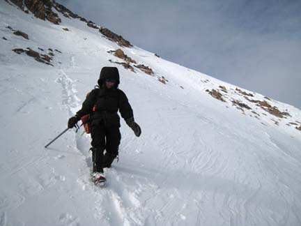
Cynthia descending the upper slope just above the cliff band.
As we descended, the weather improved and blue sky was appearing all over the place. The views continued to improve for the remainder of the afternoon and evening. The descent to 12,500' was uneventful save one of Cynthia's crampons popping off just 100 feet above where we had cached our snowshoes/snowboard so that wasn't much of a problem. I was excited to reach the snowboard and strap in for 1000 vertical feet of riding down and across the upper basin. I quickly cruised across the hard snow and while the turns weren't the highest of quality, it certainly was an efficient and fun return trip. And, nicely, I was able to see Cynthia from camp so I could monitor her progress as it was, after all, avalanche terrain. I spent the extra time melting snow, heating water and improving the snow wall around the tent to include a snow bench. As Cynthia reached the camp the clouds and sunset were making for a beautiful scene. It was damn hard to beat this outing! (Although we'd try with our next days attemp on Wilson Peak: .)
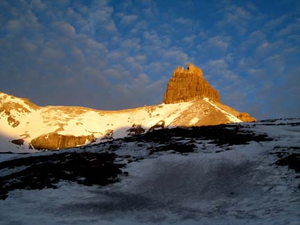
Evening light on Lizardhead seen from our high camp.
Comments or Questions
Caution: The information contained in this report may not be accurate and should not be the only resource used in preparation for your climb. Failure to have the necessary experience, physical conditioning, supplies or equipment can result in injury or death. 14ers.com and the author(s) of this report provide no warranties, either express or implied, that the information provided is accurate or reliable. By using the information provided, you agree to indemnify and hold harmless 14ers.com and the report author(s) with respect to any claims and demands against them, including any attorney fees and expenses. Please read the 14ers.com Safety and Disclaimer pages for more information.
Please respect private property: 14ers.com supports the rights of private landowners to determine how and by whom their land will be used. In Colorado, it is your responsibility to determine if land is private and to obtain the appropriate permission before entering the property.