Download Agreement, Release, and Acknowledgement of Risk:
You (the person requesting this file download) fully understand mountain climbing ("Activity") involves risks and dangers of serious bodily injury, including permanent disability, paralysis, and death ("Risks") and you fully accept and assume all such risks and all responsibility for losses, costs, and damages you incur as a result of your participation in this Activity.
You acknowledge that information in the file you have chosen to download may not be accurate and may contain errors. You agree to assume all risks when using this information and agree to release and discharge 14ers.com, 14ers Inc. and the author(s) of such information (collectively, the "Released Parties").
You hereby discharge the Released Parties from all damages, actions, claims and liabilities of any nature, specifically including, but not limited to, damages, actions, claims and liabilities arising from or related to the negligence of the Released Parties. You further agree to indemnify, hold harmless and defend 14ers.com, 14ers Inc. and each of the other Released Parties from and against any loss, damage, liability and expense, including costs and attorney fees, incurred by 14ers.com, 14ers Inc. or any of the other Released Parties as a result of you using information provided on the 14ers.com or 14ers Inc. websites.
You have read this agreement, fully understand its terms and intend it to be a complete and unconditional release of all liability to the greatest extent allowed by law and agree that if any portion of this agreement is held to be invalid the balance, notwithstanding, shall continue in full force and effect.
By clicking "OK" you agree to these terms. If you DO NOT agree, click "Cancel"...
Peak: Capitol, Elk Range Date Climbed: September 3, 2007 Group: Jon (ossie322) and Ben (benners) Route: Knife Ridge RT Distance/Elevation Gain: 17 Miles, 5,800 Feet Time: 8 Hours 25 Minutes
A long time friend of mine, Jon (or Ossie322 on 14ers.com) and I decided to go for Capitol Peak on Labor Day. For Jon, Capitol represented one of the larger hurdles in his quest for the 14ers (as it did for me a year ago and as it does for many of us). Thus our primary goal was to summit the peak, obviously. A secondary reason for me to repeat this beast was to gather some first-hand beta on the ridge direct route as Marmotman and I will be attempting Capitol on December 21 of this year.
Jon and I left from Golden at 12:30am and arrived at the Capitol Creek TH at 4:00, we hit the trail at 4:30. We decided on the increasingly popular Ditch Trail to avoid the elevation loss and hiked at a good pace under the waning crescent (moon), arriving at Capitol Lake in 2 hours flat. We took a small break, pumped some H20 from the lake and continued on to the top of the Capitol/Daly saddle. Jon and I both seemed to be on the same page for the entire day; we were able to achieve efficient rythms and move very quickly for the majority of the climb. From the saddle we traversed underneath the ridge across the large cliff band over rock outcroppings and ledge systems, reaching the boulder field 500 feet below K2 without ever losing much elevation from the saddle.
The ledge system, Mt. Daly in the background
This is the same route that USAKeller suggested in her Capitol report, it is sort of a compromise between dropping all the way down into the valley southeast of Mt. Daly and ridge hopping all the way from the saddle to K2.
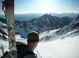
Capitol from just underneath K2
We ascended quickly to K2 and contoured underneath the summit. Here we ran into 3 people from France and Washington D.C. This was the last time we ever saw them though, we think they turned back at the knife edge.
Looking back at the Capitol/Daly saddle and Mt. Daly
Jon and I made quick work of the ridge, arriving at the base of Capitol's summit pyramid in 30 minutes. We decided to take a direct line up a class 4 ledge system leading to the summit rather than contouring around below the summit to the west. We topped out at 8:55am making the entire ascent from the car in 4hrs and 25min.
Jon downclimbing off of K2
. . . and working his way across the knife edge
Capitol's summit is great, it is a particularly rewarding summit to be on. Jon and I felt very good about our ascent time, I think we suprised ourselves at how quickly we were able to move. We snapped some photos, including one with a Which Wich bag for a free sandwich.
Free sandwich! Snowmass in the background
Pierre Lakes
After 25 minutes on the summit we began out descent. I was interested in the ridge direct route so I headed directly east off of the summit, Jon descended to the south and we eventually met lower on the ridge (we were always within earshot of each other). Mainly I was looking for rock horns and cracks and things to use for anchors when Stu and I try our winter ascent. It seemed to me that staying on or near the ridge will be our best bet, there are abundant places to throw slings around rocks to create running belays. Having gotten the beta I needed I rejoined Jon on the ridge and we quickly traversed under K2 and down the boulderfield.
Looking down the ridge direct route near the summit
A fun ridge
Looking up the ridge direct route at the summit
We traversed back across the same ledge system, arrived at the saddle and considered the 6.5 mile trek back to the car. I think it was Jon's idea but for some reason we decided to run back.
The massive north face of Capitol Peak
Jon and I ran most of the time from the saddle to the car, arriving back at the TH at 12:50pm for a round trip time of 8hrs and 20min.
The weather taking an afternoon turn
Thumbnails for uploaded photos (click to open slideshow):
I completely agree that the ledge system was the way to go. I got the idea from your TR USAKeller, so thank you! It saved us so much elevation loss and was pretty enjoyable on the way up. On the way down I wish that we had just stayed directly on the top of the ridge though. Next time right?
Traversing below that ledge system is definitely the way to go!! Too bad you couldn't join us a few weeks ago, but we'll have to get out and climb something (anything!!) soon! Awesome trip report, Ben!
Caution: The information contained in this report may not be accurate and should not be the only resource used in preparation for your climb. Failure to have the necessary experience, physical conditioning, supplies or equipment can result in injury or death. 14ers.com and the author(s) of this report provide no warranties, either express or implied, that the information provided is accurate or reliable. By using the information provided, you agree to indemnify and hold harmless 14ers.com and the report author(s) with respect to any claims and demands against them, including any attorney fees and expenses. Please read the 14ers.com Safety and Disclaimer pages for more information.
Please respect private property: 14ers.com supports the rights of private landowners to determine how and by whom their land will be used. In Colorado, it is your responsibility to determine if land is private and to obtain the appropriate permission before entering the property.