Download Agreement, Release, and Acknowledgement of Risk:
You (the person requesting this file download) fully understand mountain climbing ("Activity") involves risks and dangers of serious bodily injury, including permanent disability, paralysis, and death ("Risks") and you fully accept and assume all such risks and all responsibility for losses, costs, and damages you incur as a result of your participation in this Activity.
You acknowledge that information in the file you have chosen to download may not be accurate and may contain errors. You agree to assume all risks when using this information and agree to release and discharge 14ers.com, 14ers Inc. and the author(s) of such information (collectively, the "Released Parties").
You hereby discharge the Released Parties from all damages, actions, claims and liabilities of any nature, specifically including, but not limited to, damages, actions, claims and liabilities arising from or related to the negligence of the Released Parties. You further agree to indemnify, hold harmless and defend 14ers.com, 14ers Inc. and each of the other Released Parties from and against any loss, damage, liability and expense, including costs and attorney fees, incurred by 14ers.com, 14ers Inc. or any of the other Released Parties as a result of you using information provided on the 14ers.com or 14ers Inc. websites.
You have read this agreement, fully understand its terms and intend it to be a complete and unconditional release of all liability to the greatest extent allowed by law and agree that if any portion of this agreement is held to be invalid the balance, notwithstanding, shall continue in full force and effect.
By clicking "OK" you agree to these terms. If you DO NOT agree, click "Cancel"...
Routes: Torreys Peak's Kelso Ridge, Traverse to Grays, Traverse to Edwards, Traverse across McClellan, Descent via Jeep Couloir.
Distance: 7.42 Miles
Gain: 5,242 Feet
Participants: stevevets689, Skasgaard, Chris P., Shad
A very long time ago, I was looking randomly through route descriptions on 14ers.com to try to get a feel for what peaks outside the Sangre de Cristo Range (my home range) were like. When I took a look at Torreys Peak's Kelso Ridge route, I was instantly interested. For some reason, it just looks like a great route. So, when Kiefer (Skasgaard) proposed that we climb together sometime, I proposed a Kelso Ridge ascent for the 4th of July. He was a go. We then found out that Chris P. was going to show up as well. We decided to meet him at the Trailhead. Finally, when we arrived at the TH, we encountered Shad, who had planned to do the ridge solo but decided to tag along. The Kelso Ridge Team was assembled!
Of course, Kelso alone would not take all our time, and we decided to do Grays Peak while we were at it. Then Kiefer asked if we would like to head onto the ridge going to Mount Edwards, a Centennial 13er. Why not just knock the bastard off altogether? Ok, now we're doing three peaks. What about a descent route? Hmm, a couple of the gullies coming off of McClellan Mountain look doable. Plan set. We're getting up at 0400 for a 0430 start.
After some "extra-curricular" activites that night, including a small hike to get a better look at our surroundings, scheming to take our neighbor's Tiki Torch to the summit, and chatting with some girls from California, we hit the sacks. 0400 definitely did not roll around quickly enough, but eventually it was time to get up. We were a little late in getting up but everyone was already packed, so we were quite on time to begin the hike. We used our lights for a while, but were able to put them away after about a mile.
Kelso Ridge at dawn
About an hour in, we arrived at the climbers' trail to the Torreys Peak-Kelso Mountain saddle. The trail gets pretty steep going up to the saddle, and that was our day's introduction. Once on the saddle, Kelso Ridge looks like a jagged, complex route to say the least. The beginning is simply a trail, but before we knew it a tower was blocking our progress. As with most of the obstacles on this ridge, the tower has a few ways around or over it. Kiefer and Shad decided to go around, but Chris and I picked a more direct route, as it looked "go-able." This had us pulling a few class 4 moves, but nothing terrible. Nonetheless, since this was my first actual "climb," I decided to take the easy routes from then on, as Chris continued to take every obstacle head on.
Kiefer and Chris on typical Kelso Ridge terrain
Sunrise next to Kelso Mountain
After a good amount of class 2 and 3, I was falling behind the other guys (as usual.) Kiefer stayed back with me for the most part. The ridge basically has the theme of some class 2 ridge walking with sections of class 3 to enjoy. Kelso Ridge joins up with the North Ridge at around 13,700 feet and the ridge becomes class 2 for a good distance.
Chris climbing up Kelso Ridge
Looking back down
Kiefer climbing up Kelso Ridge
Kiefer starting up the easy section
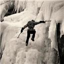
After that, we encountered the crux of Kelso Ridge: a rock buttress, leading to the Knife Edge and the White Tower. Kiefer and I took a ledge around to the right of the buttress and then up (class 3), to gain the start of the Knife. Kiefer made it across quickly and called some advice to me. Shortly, I found myself straddling the Knife myself. It is definitely not that hard, only exposed. The rock is quite "featured" with cracks and holds, so the best way across is to straddle the edge, both feet standing on holds when you have them, and hands clutching the Knife. I concentrated on my movements and got to the White Tower, which seemed easy. I traversed around the top of it to the right.
The Knife Edge and White Tower
Looking back at the Knife
Chris walking the Knife Edge
I small class 2 hike later, we were on the summit at around 0740. The Californian girls met us there, gocking at our route. We hung out a little up there, took summit shots, and continued on to the top of Grays at 0840. No story there; I'm afraid to say that I found Colorado's ninth highest peak to be pretty boring. As a class 1 hike near to Denver, Grays had hoards of happy Americans hiking to its highpoint that day. We stayed there for a little bit, and then eyed the traverse to Mount Edwards. It didn't look to be far away, but looks can be deceiving.
Grays Peak from the summit of Torreys
The traverse to Mt. Edwards
We took a well worn trail off of Grays' summit and headed in the direction of our Centennial. The ridge takes a lot of ups and downs with many false summits. Even the false summits had their own false summits. It took about another two hours to reach this summit, with a bit of scrambling on the way. Of course, since no one seems to climb 13ers, we had this mountain to ourselves. We tried to count the number of people hiking Grays, but could not put a number to them. Anyway, clouds were building, time to begin the descent.
Proctor of the Grays-Edwards traverse
The Edwards Traverse
McClellan Mountain viewed while climbing Mt. Edwards
Grays and Torreys from the summit of Edwards
Evans and Bierstadt from the summit of Edwards
We traversed over McClellan Mountain, an unranked 13er with just over 150 feet of prominence. We passed a couple ATVs and their owners parked near the summit, looking down the impressive east face. We hiked on easy terrain for a while until we found the gully we had planned on descending with a dilapidated vehicle parked about a quarter of the way up.
Heading up McClellan Mountain
Chris, Shad and Kiefer on the summit of McClellan
Starting down the gully
At the top of this gully, my "Mountaineering 101" moved into a difficult section. The gully is amazingly loose, and any move you make will send you and countless rocks sliding from six inches to four feet or more down-slope. Our axes came out and the other three guys gave me their best guidance of how to use it to aid my descent. It took some getting used to, but I did eventually figure it out. That did not make this descent easy, however... how could 1,300 vertical feet of evil, frictionless rock be easy? It took us around two hours to get back into the valley floor, beating out a thunderstorm just in the nick of time *whew*.
Our descent route
Google Earth image of our route from near McClellan Mountain
Back at the parking lot a few minutes later, I mused at the day's accomplishments. I had: doubled my 14er list for the second time (from two to four), doubled my centennial 13er list (from one to two), accomplished my first big Front Range peaks, climbed my first sustained class 3 terrain routes (thoroughly enjoyed them as well), and tagged three ranked peaks in one day with 7.42 miles and 5,242 feet of gain. What a way to spend the 4th!
For more pictures from this climb, please visit my homepage: .
Thumbnails for uploaded photos (click to open slideshow):
Steve, way to go man! You wrote a great TR and the pics are outstanding! I am a sucker for animal shots...love those goats! We had snow in the gullies for the descent from Edwards/Mclellan summit...much easier than the nasty scree!
Sweet little report here, Steve. We'll definately be doing more scrambles and climbs in the future, count on it! This is a good report, Steve and Congrats on navigating that scree nightmare gully.
BTW, I'll bring more beer next time!
Thanks for the great report, I've been looking at bagging this pair, and the Kelso Ridge looks like the way to go. was there much traffic on that route or did you have it to yourself?
Wasn't hard, you said? I'm dong Capitol the 29th and was told I should do the knife edge on Kelso first. Your pics and descriptions were helpful Way to get those lame peaks out of the way the cool way
Caution: The information contained in this report may not be accurate and should not be the only resource used in preparation for your climb. Failure to have the necessary experience, physical conditioning, supplies or equipment can result in injury or death. 14ers.com and the author(s) of this report provide no warranties, either express or implied, that the information provided is accurate or reliable. By using the information provided, you agree to indemnify and hold harmless 14ers.com and the report author(s) with respect to any claims and demands against them, including any attorney fees and expenses. Please read the 14ers.com Safety and Disclaimer pages for more information.
Please respect private property: 14ers.com supports the rights of private landowners to determine how and by whom their land will be used. In Colorado, it is your responsibility to determine if land is private and to obtain the appropriate permission before entering the property.