Download Agreement, Release, and Acknowledgement of Risk:
You (the person requesting this file download) fully understand mountain climbing ("Activity") involves risks and dangers of serious bodily injury, including permanent disability, paralysis, and death ("Risks") and you fully accept and assume all such risks and all responsibility for losses, costs, and damages you incur as a result of your participation in this Activity.
You acknowledge that information in the file you have chosen to download may not be accurate and may contain errors. You agree to assume all risks when using this information and agree to release and discharge 14ers.com, 14ers Inc. and the author(s) of such information (collectively, the "Released Parties").
You hereby discharge the Released Parties from all damages, actions, claims and liabilities of any nature, specifically including, but not limited to, damages, actions, claims and liabilities arising from or related to the negligence of the Released Parties. You further agree to indemnify, hold harmless and defend 14ers.com, 14ers Inc. and each of the other Released Parties from and against any loss, damage, liability and expense, including costs and attorney fees, incurred by 14ers.com, 14ers Inc. or any of the other Released Parties as a result of you using information provided on the 14ers.com or 14ers Inc. websites.
You have read this agreement, fully understand its terms and intend it to be a complete and unconditional release of all liability to the greatest extent allowed by law and agree that if any portion of this agreement is held to be invalid the balance, notwithstanding, shall continue in full force and effect.
By clicking "OK" you agree to these terms. If you DO NOT agree, click "Cancel"...
Itinerary:
Day 1: Left Snowmass Creek Trailhead at elevation 8,400 ft. at 4:15pm and hiked 8 miles and camped about a 1/4 mile below Snowmass Lake by 8:30pm at 10,800 ft.
Day 2: Left camp at 5:30am and summited Snowmass via the East Slopes around 11:30am.
Day 3: Broke camp near Snowmass Lake at 10am and hiked over Buckskin Pass and started up the standard approach to North Maroon and made camp.
Day 4: Left camp at 5am and summited North Maroon at 9:30am. Descended via Maroon Lake and drove back to Snowmass Creek Trailhead to pick up Jeep and got to Aspen Brewing by 3pm.
A few miles into the standard Snowmass Creek Approach you will hike through some beautiful Aspens.
About 6 miles up the approach to Snowmass Lake you come across the log jam. There were some good camp spots around this location. If you are tired of hauling a heavy pack, this is a good place to camp. Otherwise you need to push another 1.5 miles up some steeper switch backs before you get to other viable camp sites.
In the morning of day two, we hiked up to Snowmass Lake and filtered water and got some great photos of Hagerman Peak, Snowmass, and Snowmass Lake.
The next photo shows the route up the East Slopes of Snowmass taken from Snowmass Lake. We climbed with ice axes so we were able to take a more direct line up the snowfield near the summit. This allowed us to bypass a lot of the loose dangerous rock on the ridge.
The path through the willows around the left side of the lake requires some patience in the early morning because there are a few trails that lead away from the Lake. We actually were a little higher than we needed to be on one of those trails and had to down climb back toward the lake at one point on the ascent.
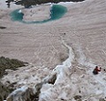
The next photo looks back down to Snowmass Lake near the steep, loose section of the climb. There isn't a good sustainable trail during this steep section. So you'll have to push through this part. The steep scree from 11,300 to 12,000 feet was the least enjoyable section of this route.
The next photo shows Stiffler_From_Denver gaining the ridge below the summit by climbing the snow field.
When you take the more direct variation route up the snow field, you don't have much of the ridge to navigate before you're on the summit.
Here's the obligatory Snowmass summit shot of Exiled Michigander and Stiffler_From_Denver.
We met a group of climbers what had various skill levels between them: some with many 14er summits and one young lady who had only done one easy class 1 summit before attempting Snowmass. We were disappointed to see that the so-called experienced hikers that brought her up Snowmass quickly hiked ahead and left the newer hiker to route-find and tackle Snowmass's loose exposed ridge on her own. So just a reminder to climbers out there to stay together and be cognizant about introducing new climbers to the rotten Elk range rock.
The next photo shows the Exiled Michigander beginning his descent down the steep snowfield with an ice axe. Again, this route should only be done with an ice axe.
Here's Exiled Michigander starting to descent the top of the snow
The snowfield gave up some good spots to glissade safely with our axes.
Exiled Michigander takes a break and admires the scenery and wild flowers.
After a successful summit of Snowmass, we chilled around the lake for bit before heading back to camp for some dehydrated beef stroganoff and some camping.
The next day we broke camp and made the trip over Buckskin Pass to position ourselves for a summit attempt on North Maroon for the following day. Here's a great view looking back at Snowmass from Buckskin.
You get great views of Maroon from Buckskin Pass.
We had to drop down below 11,000 feet to reach the turn off for the North Maroon trail. We continued up to about 11,500 where there are a few good places to camp and a lot of intrigued mountain goats. The steep talus section around 11,200 has a number of very well-constructed stone stairs.
Camping this high up allowed us to start at the boulder field first thing and get to the first gulley and the real climbing very early on.
The following morning, we met BNCPatrick at our camp at 11,500 feet at 5am who had left the parking lot at Maroon Lake at 3am. So we were crossing the boulder field in the dark and made the turn to start up the first gulley right around 6am.
This photo looks down the second gulley.
After route-finding up the first and second gulleys, there is still a lot of fun climbing remaining before the summit. Above the second gulley you'll discover the class 4 chimney move.
Above the chimney move you still have to contend with that loose Elk rock but you get great views of Capitol and Snowmass.
Summit photo of BNCPatrick, Stiffler_From_Denver, and Exiled Michigander with Snowmass and Capitol in the background.
Some more photos of the steep descent
Thoughts:
Snowmass and North Maroon were my 42nd and 43rd 14ers. Of all my 14er trips, this one left me feeling the most accomplished because I had been nervous about these two for some time given each's ability to cause injury or worse. It's hard to find more breath-taking views than the beautiful sights I saw on Snowmass, Buckskin Pass and North Maroon. This was a great way to knock out two Elk Range 14ers and get to see part of the 4-Pass Loop trail.
Thumbnails for uploaded photos (click to open slideshow):
When camping at Snowmass, what would you say the temp was over night? I'll be there in late August, wondering how cool it may get for sleeping. Thoughts on best place to camp the night before climbing Snowmass? Enjoyed your write up, thank you for sharing.
Caution: The information contained in this report may not be accurate and should not be the only resource used in preparation for your climb. Failure to have the necessary experience, physical conditioning, supplies or equipment can result in injury or death. 14ers.com and the author(s) of this report provide no warranties, either express or implied, that the information provided is accurate or reliable. By using the information provided, you agree to indemnify and hold harmless 14ers.com and the report author(s) with respect to any claims and demands against them, including any attorney fees and expenses. Please read the 14ers.com Safety and Disclaimer pages for more information.
Please respect private property: 14ers.com supports the rights of private landowners to determine how and by whom their land will be used. In Colorado, it is your responsibility to determine if land is private and to obtain the appropriate permission before entering the property.


")
")
")
")
")
")
")
")
")
")
")
")
")
")
")
")
")
")
")
")