| Peak(s): |
Mt. Aetna - 13,747 feet Unnamed 13440 - 13,440 feet Bull Hill - 13,758 feet |
| Date Posted: | 05/18/2016 |
| Date Climbed: | 05/12/2016 |
| Author: | bergsteigen |
| Additional Members: | BillMiddlebrook, EatinHardtack, Leopard233, cliz |
| Peak(s): |
Mt. Aetna - 13,747 feet Unnamed 13440 - 13,440 feet Bull Hill - 13,758 feet |
| Date Posted: | 05/18/2016 |
| Date Climbed: | 05/12/2016 |
| Author: | bergsteigen |
| Additional Members: | BillMiddlebrook, EatinHardtack, Leopard233, cliz |
| Tale of Three 13ers: The Good, the Bad and the Ugly |
|---|
Mt Aetna: The GoodTrailhead: Monarch Lodge Mileage: 8.13 Elevation Gain: 4000' Partners: Bill and Zach Route: Grand Couloir We had planned to ski this route the previous weekend, but the weather just wasn't cooperating. So with Thursday's weather, we were finally a go. It was pretty amazing that none of us had skied this line before. It's a classic! Bill had talked to the owner of the Monarch Lodge, so we were parking there. The snowmobile business at the start of the 4WD road has no parking signs all over the place, and when Bill checked the road (only open for about a half mile), he didn't notice the tiny winter trailhead parking. I had been up Taylor and Aetna in late fall, and did a hut trip to the base of the Grand Couloir, and managed to park in various places based on the road and parking situation. But better safe than sorry when parking next to ornery businesses. So at o-dark thirty, we started booting up the road. We saw the point where Bill turned around at the first patch of snow, and kept booting, since the road was still quite patchy for some time. At the turn off for the road where we started for Taylor, we finally switched over to skinning. We made short work of the approach, and as we made it to the base of the avy debris fan at the base of the couloir, the sun was starting to peak up over the horizon and make the world light again. Though we had a strong wind coming down the face of the couloir at us. In the dark, this was a very chilly wind, and after a short break, we all started up the couloir at our own pace to keep warm. Looking at this couloir from Monarch Pass, I didn't quite realize that we could skin most of it, until the upper stretch, but that made for a very simple and easy approach!    After a very frozen approach where we were quite chilled by the wind, we took a break and waited for the sun to hit our position. Oh the celebration as the sun reached our fingers and finally our feet! It took awhile to fully warm up, or at least beat the screaming barfies in the hands, but the morale boost was quite nice. On with the crampons for the rest of the climb. At first, not bad. But then came the fresh snow from the few days before. Below it was dust on crust. Up here, it was actually getting thick. Bill plowed through the snow for as long as he could. Even making a snow angel at one point (couldn't get the camera out quick enough for that shot). When he got tired, he thought Zach should take over, but I decided to take lead, since I had fresh legs.   Bill booting up  All bundled up - Photo Credit:Bill  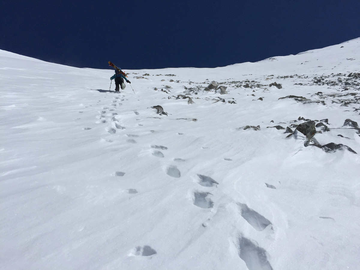 Pinch Booter - Photo Credit:Bill  Tilting the camera makes the slope look steeper. Or maybe I was a bit off kilter trying to not fall down the slope while taking a photo After the end around the rocks, it was a short traverse over to the summit, where amazingly the wind died down. Quite nice now in the sun, as I waited for the guys to show up. With the wind and the sun only arriving recently, we were going to have a nice long wait on the summit for the snow to soften. I like a little bit of waiting on the summit. Too much spring skiing is racing up and down!   Zach topping out  Bill taking a nap at the top of the climb  Bill finishing his nap on a more horizontal surface   After a nice long rest on the summit, it was finally time to ski this wonderful big long line! Bill starts the traverse out first to test the fresh snow. Not seeing anything troubling, he calls us over. Still following the ski protocol, we ski individually watching each other - just in case. Bill drops first and jumps around in the thick fresh snow. Nothing moved, so I was good to go once Bill got to a safe spot. I dropped below and waited for Zach to make his way down to us. From there it was a fun leap frog down the couloir. At our transition point on the way up, the slope dropped off dramatically and the corn really came into its own. By the bottom, we had to be a bit more careful, as the snow wanted to grab our skis a bit. I even took a hip as the deep snow caught me by surprise.   Me making the first turn down the Grand - Photo Credit: Zach  Me dropping below Bill on the first drop - Photo Credit: Bill  Zach skiing the upper zone  Zach skiing past Bill - Photo Credit: Bill   Zach ripping past me  Me skiing with a view - Photo Credit: Bill  Zach kicking up some freshies!  Me approaching our transition spot, and the lower couloir - Photo Credit: Bill  Me dropping the lower couloir - Photo Credit: Bill  Bill avoiding my powder pit and making it look easy, as usual.   Slush running up my ski boots, but there's a smile on my face - Photo Credit: Bill   Happy to have skied a really fun line! - Photo Credit: Bill Once back down to the trail, it was a fairly easy egress out. The snow was still supportive, and we only had to stomp up a few little hills and around one mini stream crossing. Even the final boot out was short and easy! Ah, the GOOD ski. This is why we do this!  Pt 13,460: The BadTrailhead: LaPlata Gulch Mileage: 9.73 Elevation Gain: 3,993' Partner: solo Route: North Face, East Face saddle After leaving Bill and Zach, I refueled in Salida and headed up to the South Elbert campsite to make sure I knew where the gathering was, and to have great cell reception. Kinda nice to be stay connected until you fall asleep. The next morning I was in no rush. I was skiing a north facing line, so I could sleep another hour or 2. I was treated to a wonderful sunrise from camp, and on the drive up to the regular LaPlata trailhead.  Red clouds in Twin Lakes  Sun blushed Mt Hope  Sunrise reflections on 3 13ers I got to the empty trailhead and quickly geared up for my exploratory ski. I had attempted this peak last year after a ski of Sayres Benchmark. But I had started a bit too late, the freeze wasn't very good, and I chose a bad route. I got into some super steep trees, and I could no longer skin uphill well, so I tried transitioning to booting. All I managed to do was wallow up to my chest horizontally. No uphill movement. So after looking at my watch, and realizing that I couldn't go down and try another route, I had to call it. But so it goes with adventure, sometimes you win, sometimes you turn around. Today the freeze was pretty good, and I booted up the road and started to investigate the stream crossing. It was not going to be fun. Too deep and wide to cross with boots, and I forgot my sandals, so I would have to go barefoot in the mine polluted stream - yuck! I found a shallow but wide section and took off my ski boots. Cold and icy slimy. I got to the other side, and all I could think of was - I have to cross this in the afternoon? Do I want to? I guess I could drop the east side to egress...  After putting my boots back on and battling the willows, I started skinning up to the rock and avy debris zone that had fewer trees. I figured this had to be a better route than my previous attempt, even though it was a bit steeper. With the hard snow and frequent tiny trees, the going was slow. The thought of skiing this with mashed potato collapsible snow was also weighing heavily on my mind. This would suck and be potentially dangerous. Hmmmm. After getting out of the tiny trees, the skinning got easy for a little bit, until it got too steep for my skins. So I started the transition to crampons. Should have stuck my skis into the snow, as one ski made a break for it (despite my brakes) and slid down hill. Thankfully it stopped, and I had to go and down climb 20-30 feet to get it. From there it was an easy booter up the rock strewn slope to the base of the north face and ridge. Even the rock strewn slope didn't look like a great ski either. I guess I will have to find a safe way down the east side of the ridge. As I got closer, I figured I would gain the ridge further lookers left and use that as my reclimb position too. Why make 2 booters? The line I wanted to ski looked wind loaded on one side, and wind scoured on the other. So if I ski down the center, I get powder, but little danger. Awesome!   I got to the ridge and saw the huge cornices almost 100% of the length of the ridge. Hmmm I hope as I go up, I'll get a good view of my surroundings and see something better to drop the east side. I made sure to give the cornices a huge berth as I went up the ridge. The wind had been howling up from behind me the entire climb up. No rush at all, since it was keeping the snow very cold. But as I reached the summit, the wind stopped and the solar oven turned on. Quite the views all around. The other summit area bugged me though. It looked really close to my elevation. Did I chose the right summit? Would I "fail" a second time. The north face off that summit looked mellow, so I guess I could return for it, again. No data service up here, so I couldn't check. At least the line off this summit was more interesting, it would be a great ski irregardless. But it does turn out I had the real summit, so that's good.      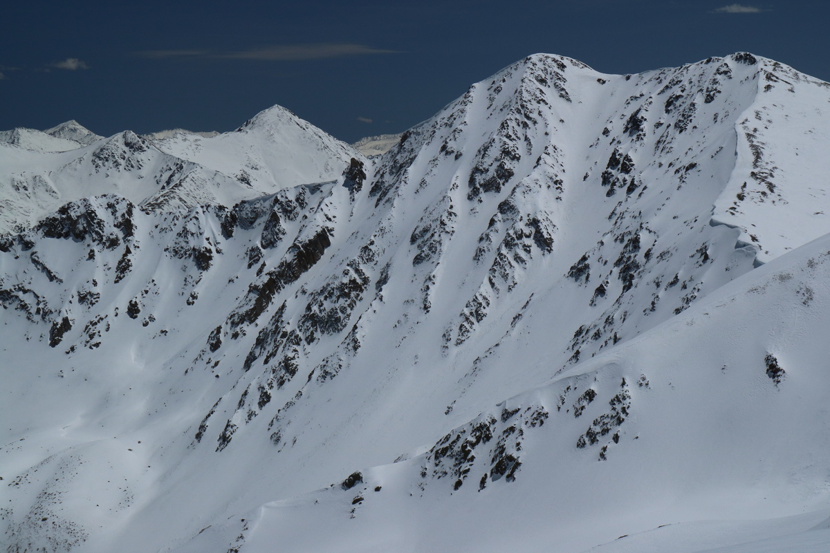 Sayres Benchmark with Xrated and Grand Central Couloirs After dropping onto the north face and contouring around to the ridge, I carefully made my way over to the start of my line. Can't get too risky with that cornice. The start of the line was all nice and fluffy and cold as I made my first set of turns. As I got lower down, I started to notice a bit of warming, but nothing significant. At the base, the new snow was a lot thinner, and I got a firm bite into the base with my edges for the last couple turns as I avoided the slough debris. I stopped briefly at he base to admire my success, and then traversed high over to my booter. It was hot! Time to get off the snow.  View down my north couloir  Powder turns! You can see the transition from cold powder up top, to warming up snow below. Bottom was corn.  View of my line and summit area from my reclimb As I got to the top of the ridge and saddle with 13300D, I found one of the few zones without a cornice and the lowest angle slope on the east side. Since it was now late in the day, I wanted to ski the lowest angle slope possible off the east ridge to avoid any wet slides. Quick transition back to skiing, and I found my entrance. I tested the start, and the wind that had been howling all morning had been keeping the entrance cool. A few feet below though, and it was all corn. Got in a few nice big corn turns before I turned to follow the drainage out and around. Nice low angle corn turns all the way down into the bottom of the valley, where I got a nice view of last years ski on Sayres. It looks so nice right now! Wish I could go ski X-rated, it looks fat!     Creamy turns off the ridge. My entrance point by the rocky breach in the cornice.  Low angle cream  I figured the egress out on this side *should* be easier than the steep and nasty on the other drainage. At first the slide out was easy, then it got a bit unsupportive. I couldn't wait to get into the trees! Maybe there the snow would be a bit better. I had seen tracks on the other side of the stream before, and I was really really curious. Would it be better than skiing down the trail? Since if I try to ski it now, it will be a post hole with skis on fest. I'll ruin the trail for any gathering types coming up tomorrow. So curiosity got the best of me and I skied down on the other side. At first not so bad. Then the downed trees happened. And the steep slope with downed trees. Every contour line was an accomplishment as I ski traversed down through the mangled mess. Eventually the slope eased off as I neared the trail, and even the downed trees became less. But where was this trail? I had a trail marked on my GPS, but I passed over it without seeing tracks. So I ended up next to the big stream gully where the bridge is, and no bridge. So I skied next to the stream, high up on the plateau until I found the trail and the bridge. Woohoo! The bushwhack is over! As I start over the bridge, I hear voices, which is impressive since the stream is roaring with evening snow melt. It's Scott and Britt! They were scoping out the trail and way up Sayres for the next day. So we hiked out the last bit of trail together and I told them of my adventures of the day. Even got to show them the line I skied from the main bridge.  It was nice to get the peak and line I wanted to ski on try #2. This is true freedom of the hills. See a line - ski a line. Looking at photos, topos and just going out adventuring. Sometimes that adventure involves nasty bushwhacks on the approach or egress, but the ski line makes it all worth it. Have to take the bad with the good! Bull Hill: The UglyTrailheads: Echo Canyon to Black Cloud Mileage: 7.5 Elevation Gain: 3,786' Partners: Bill, Zach, Craig, Ben, Sam Route: ESE Face Arriving at the gathering campsite, I see Bill and Craig parked in my spot from the evening before. So to keep the skiers together, I pull up behind them. We wait for Zach and his friend Sam to show up. But in the meantime, what do we ski? The freeze will be marginal, and the next day will be hot. Wallowing after LaPlata sounds horrid, even if the north face looks stacked. I've skied Lackawanna's southwest couloir already. Nice but no need to repeat that just yet. So after a while, we settled on Bull Hill. I had a photo from the day before showing the mining road - partially in snow. The west facing couloirs looked fun, and we could sleep in. Or there was an east face that could be good and corny once we summit too. With all the vehicles, we could even car shuttle to keep our options open. At the gathering, we make the acquaintance of another skier that wants to join. We lose Nick and Ben, but gain another Ben. Couldn't stay long talking to friends I hadn't seen in a few years, we had a 3:45am start time! Thanks to ear plugs, I missed the neighboring unrelated gathering's hooting and hollering all night long. Their campsite was still awake as we drove past! We drop Sam and Ben's truck over at the eastern trailhead, and drive on to Echo Canyon, where there's just enough room for 3 cars, sort of. We gear up and the guys realize they can't boot up in hiking shoes and leave them (without having to hike back up in the afternoon), so we all start out in ski boots. Up the road and then onto a trail that looks like an old overgrown road. Mostly booting on dry trail to start, but soon enough the snow patches start. With our skis on the back, post holing through unsupportive snow is tiring, but we're all together in our wallowing. Much cursing throughout the group. It's a rough go. The ugly has begun. We decide that it would be easier to claw our way up a steep slope to get up to the road, than to continue on the trail section we're on. There we can finally put our skins on our skis and make easy work of it. Or so I thought. Around the next switchback, Zach looks back and says to not get excited. So off with the skis. Then on, then off... repeat repeat repeat. I think in total there were 14 or more transitions. Not efficient, slow going and just really really ugly. So have you heard the joke about the woman with really small hands? They make her skis look so huge!!! So note to all future and current partners. I can't carry my skis in my hands and post hole, walk on ice or wobbly rocks. Skis go on my pack. I've already proven just walking can break my leg. No need to complicate that with wobbly skis that kill my balance. So I lost 5-10 minutes each transition putting skis on and off my pack. By then end, I was beyond exhausted. I bushwhacked through trees carrying my skis to avoid the last transition. I was done. If there was a ski down at this point. I may have bailed. This approach was horrid to me. Not my style. But then, the snow became continuous. So I decided to cut a switchback on the continuous snow and I managed to beat the group up! Ha! A bit of steep skinning saves the day. From there up, was steep icy and sloping skin along the road, but this was so much easier than before. For me at least. Craig was having problems and kept sliding downhill, so he ended up carrying his skis. Just proving, what works for one person, doesn't work for everyone. Unfortunately the west side gullies all had slide debris, and I don't think any of us wanted to go out on that "trail". So east side time!  Morning light on LaPlata     At the mine and end of the road, we booted on up to the ridge. From there, it was a quick jaunt over to the summit. The ugly was over, for now. At first it was only Ben and me skinning up the slope. Then Sam converted, and eventually Zach. Half way, Craig transitioned to skinning. Bill was the lone hold out and booted the entire way up to the summit. The wind started as soon as we got to the ridge, and followed us up onto the summit. Had hoped that it would stop, just like the last couple days, but no go. It stayed windy, so we huddled and got our skins off, ate and drank and relaxed a little bit. But soon we were off! Time to gang ski some corn!  The group skinning up - Photo Credit: Bill  Craig and Bill making their way up  Summit transition - Photo Credit: Zach      We decided to wrap around the summit area to the north then around, since the east face was a bit rocky in places. With 6 of us, it was good the terrain was fairly gentle, so we could simul ski it. We had roving clouds that made skiing difficult. So we tried to find the sunny patches to ski. Sometimes we waited for them. Other times, not. We would yell sun! and all gang ski lower down. Leap frog simul ski. A rare treat, except for the photographer.   Craig taking a spin downhill with Elbert behind  Sam skiing the initial drop in the clouds  Big face ski, with Sam ripping - Photo Credit: Bill  Ben's turn - Photo Credit: Bill  Ben carving - Photo Credit: Bill  Me coming in HOT- Photo Credit: Bill  Me skiing down with LaPlata behind - Photo Credit: Zach  Zack pointing the pink pole  Ben Skiing down  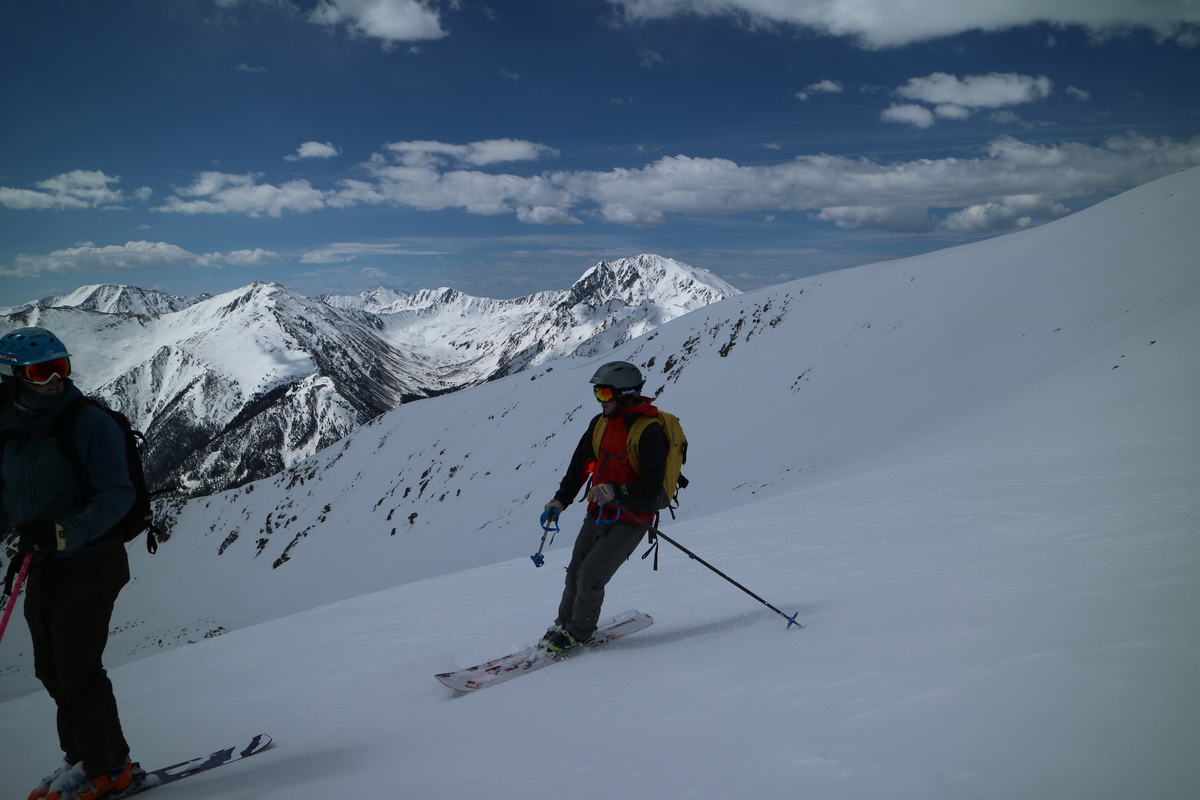 Sam coming to a stop in front of LaPlata  Sun's out, gang ski!  Bill and Zach enjoying the corn  Gang skiing! - Photo Credit: Zach  Bill skiing a farther drop with Elbert behind    The gang nearing the end of the easy ski - Photo Credit: Zach  We managed to ski pretty far down into the drainage, and I even skied all the way to the trail and the end of the snow, almost. The snow got collapsable in places, and most people fell at least once. We walked through mossy streams, crossed a couple dry patches and downed trees. But soon the downhill easy slide was over. So skis on the pack and a dry trail was had for the last 0.75 mile. By the end, it got hot. Really hot, and we were all happy to make it to the car shuttle. The day started out really ugly, with post hole wallowing, transition mania, and steep side hill skinning, but then the ugly transitioned into the sweet. Sweet enough to forget the ugly of the morning. We relaxed for a while at this trailhead, before finally shuttling to get cars and relax some more in good company. Thumbnails for uploaded photos (click to open slideshow):  Starting up the Grand")
 Bill breaking trail up the couloir")
 We skinned till here")
 Bill and Zack starting the boot pack")
 Zach making his way up")
 Zach and Bill on the dogleg")
 Ouray and friends")
 Shavano group")
 Bill starting down the Grand")
 Bill skiing in the upper couloir")
 View of the line")
 What ski mountaineers do after skiing a line: Take a photo!")
 Aetna from Monarch Pass")
 13460 from the road")
 Approaching the north face")
 Looking at the north facing ridge line")
 View of the summit from the saddle")
 Grizzly")
 Lackawanna")
 Elbert and Bull Hill")
 La Plata")
 Nearing the ridge on my reclimb - my tracks up and ski down visible in the snow")
 Summit ridge from drop point #2")
 Sayres Benchmark - check out that X Rated!")
 Skiing out with Sayres behind")
 View of my tracks from the road")
 Lackawanna's more impressive east face")
 La PLata")
 Bill on the slopey icy mining road on Bull Hill")
 Booting and Ben skinning")
 Casco")
 French")
 La Plata")
 Elbert")
 Massive")
 Craig skiing in the sun with Elbert behind")
 Zach skiing with a view behind")
 The ESE face of Bull Hill")
 Tracks out in the lower drainage")
 Skiing into the woods, now the fun begins")
|
| Comments or Questions |
|---|
|
|
Caution: The information contained in this report may not be accurate and should not be the only resource used in preparation for your climb. Failure to have the necessary experience, physical conditioning, supplies or equipment can result in injury or death. 14ers.com and the author(s) of this report provide no warranties, either express or implied, that the information provided is accurate or reliable. By using the information provided, you agree to indemnify and hold harmless 14ers.com and the report author(s) with respect to any claims and demands against them, including any attorney fees and expenses. Please read the 14ers.com Safety and Disclaimer pages for more information.

