Download Agreement, Release, and Acknowledgement of Risk:
You (the person requesting this file download) fully understand mountain climbing ("Activity") involves risks and dangers of serious bodily injury, including permanent disability, paralysis, and death ("Risks") and you fully accept and assume all such risks and all responsibility for losses, costs, and damages you incur as a result of your participation in this Activity.
You acknowledge that information in the file you have chosen to download may not be accurate and may contain errors. You agree to assume all risks when using this information and agree to release and discharge 14ers.com, 14ers Inc. and the author(s) of such information (collectively, the "Released Parties").
You hereby discharge the Released Parties from all damages, actions, claims and liabilities of any nature, specifically including, but not limited to, damages, actions, claims and liabilities arising from or related to the negligence of the Released Parties. You further agree to indemnify, hold harmless and defend 14ers.com, 14ers Inc. and each of the other Released Parties from and against any loss, damage, liability and expense, including costs and attorney fees, incurred by 14ers.com, 14ers Inc. or any of the other Released Parties as a result of you using information provided on the 14ers.com or 14ers Inc. websites.
You have read this agreement, fully understand its terms and intend it to be a complete and unconditional release of all liability to the greatest extent allowed by law and agree that if any portion of this agreement is held to be invalid the balance, notwithstanding, shall continue in full force and effect.
By clicking "OK" you agree to these terms. If you DO NOT agree, click "Cancel"...
This TR details an attempted ski descent of Mt. Shasta via the Avalanche Gulch route by me and my wife, Chelsea, this past weekend (April 30-May 1, 2016). Mt. Shasta is a very special place for us and this is not our first time there, and I could go into a lot of detail on these things, but I'll try to keep this succinct and informative to convey the lessons we learned for those aspiring to ski (or just climb) this magnificent mountain.
In somewhat characteristic style for us, the plan for this trip was hatched on Tuesday, April 26 - five days before anticipated summit day. As has previously been the case, the original impetus was the particularly abysmal weekend forecast for the entire state of Colorado. In contrast, the entire northern half of the west coast was supposed to enjoy sunny skies and warm temperatures the entire weekend, but particularly on Sunday. In addition, recent condition reports suggested that Shasta's south-facing Avalanche Gulch route was in prime condition for climbing in skiing, with good freeze-thaw cycles promoting corn formation. The temptation was irresistible: a Cascade volcano climb followed by a 7000-plus-foot descent back to the trailhead? Kind of hard to beat. On top of that, nearby Ashland, Oregon happens to be Chelsea's hometown, and my father-in-law still lives there. So, it would be a mountain trip AND family trip all in one. What could be better?
Three days later, giant duffel bags bursting with skimo gear, we're off to DIA, thrilled to be leaving the wintery mix of the Front Range behind. The next morning, we're headed down south along I-5 in a borrowed Tundra with a camper top. As we pass into California, our mighty objective comes into view. Holy crap, that mountain is huge. Among all the mountains in the lower 48, only Rainier beats Shasta in prominence...no doubt this vastness is part of its magical lure. After a few last-minute errands in Shasta City (word to the wise: the new hardware store, Solano's, in the shopping center on Commercial Ave off of Lake St., carries an entirely respectable selection of freeze-dried), we're at the Bunny Flat trailhead (el. 6800'). It is PACKED. We end up having to turn around and drive a few hundred yards back down the road before we can even find a spot for the hefty truck. After a quick lunch, we pack up, fill out our permits, click into our skins and start skinning up toward Lake Helen - the high camp at 10,400' on the mountain.
Ready to go! Thanks truck
Snow was fully continuous all the way to the trailhead, allowing for uninterrupted skinning. Despite somewhat chilly temperatures, especially when a stray cloud obscured the sun or the breeze picked up a little, the snow was in prime corn condition on that beautiful afternoon. Shasta's immense south face, with the Avalanche Gulch route visible up to about the top of the Red Banks (~13,000'), was in full view. The first couple miles of Avalanche Gulch are very low-angle, easy skinning. Still, with overnight packs, avy gear, etc., it was fairly hard work (this was our first ever overnight ski trip that involved camping, rather than a hut). But the skinning conditions were excellent, and the beauty of the surroundings, along with the anticipation of the descent as we watched skiers float down the vast, undulating terrain of Avalanche Gulch, took our minds off the effort. Moreover, conditions on the upper route looked excellent, with continuous coverage on the upper headwall connecting to the Thumb Rock saddle and beyond. Summit day looked as promising as ever.
Blubird day on Shasta
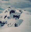
View from the approach. That mountain is BIG
Around 8500 feet (a little ways above the Horse Camp cabin), the terrain steepens somewhat. Avalanche gulch actually has two drainages; the main ascent route (when covered with snow) takes the climber's left (west) drainage, closer to the craggy Casaval Ridge, while on the downhill many skiers take the slightly steeper east drainage, closer to Green Butte. The pitch alternates between steeper 25-30 degree headwalls separated by gentler "rests"; however, the entire thing was very much skinnable. Skinning up the gulchThe Casaval Ridge Due to our very late start, we arrived at Lake Helen around 6 PM - just as the snow was beginning to firm up again. This "lake" (which presumably does exist somewhere under the snow, though apparently it has only melted out a couple of times in the last century) is hidden in a shallow depression that creates a low, but fairly long (maybe a few hundred yards), natural wind block, resulting in a very peculiar high camp consisting of a line of tents strung out along the barrier, with varying degrees of additional protection depending on people's level of laziness and faith that the present windless conditions (a true rarity on Shasta) will last. Knowing better, we took about half an hour to make at least a passable shelter for our 4-season EV-2; melted a bunch of snow; ate dinner; enjoyed the beautiful sunset (the colors in this part of the world are something else!); and went to sleep in the almost eerily still night, in eager anticipation of our summit attempt.
Red Banks from Lake Helen
Melting snow at camp
Casaval at dusk
State of Jefferson colors
We woke up around 4 for a 5 AM departure. The temperature had dropped enough that our water bottles were starting to freeze even inside sleeping bags in the tent, so we had to add a little hot water to keep them from freezing on the climb. We were trying to walk a fine line between having plenty of time for the ascent and to be off the Red Banks before icefall from the rimed-up cliffs around the Red Banks became an issue, but late enough for the snow to soften up. Frankly, looking at the condition of the snowpack at Lake Helen and above, we were starting to have doubts as to whether that would happen at all: the snow was crusted over, very firm and wind-affected; it did not look like it had gone through much of a freeze-thaw cycle yet. However, the forecast temps for Sunday were supposed to be quite warm, so we held on to some hope. Worse came to worse, we would suck it up and carry our skis down until the skiing became reasonable (neither of us is a competent enough skier to descend no-fall terrain like upper Avy Gulch in icy conditions, so we agreed in advance that this would be the preferred course of action if conditions weren't favorable). And so, up we went. Chelsea immediately put on crampons and began booting, while I tried to skin up the initial, lower-angle slopes leading up into the steeper throat of the gulch. Chelsea's choice was the smarter one: no more than 10 minutes in, I found myself slipping and sliding on the frozen early morning snow, and was soon cramponing up with skis on my back as well. The transition was a bit unfortunate, as a good deal of the surface contained a breakable crust that made booting a bit tedious: ski crampons could work well for this section, but, alas, we didn't have any. So, up we went, the usual way: step, step, rest, etc. etc., inching up the giant, 2500-foot snow face.
In "typical" climbing season (i.e. about mid-May to late June), climbers often have a choice of ways to ascend the upper Avalanche Gulch headwall through the Red Banks. The lowest-angle option - a steady 35-degree pitch for the upper 1000 feet or so - takes the climber's right side of the bowl toward a prominent feature appropriately named Thumb Rock, from which there are a couple of ways of getting through or around the Red Banks. Later in the season, the upper parts of this slope can melt out revealing nasty scree, so people opt either for the steeper "left of heart" (a large, heart-shaped area of rock that forms in the middle of the upper snowfield), or through one of the steep, narrow chutes that penetrate the Banks. This time of year, however, the latter options were all covered in thick rime ice, so the vast majority of climbers, ourselves included, opted for the right-hand variation, which had no coverage issues whatsoever (indeed, the Heart wasn't visible at all). There were already many climbers (and some skiers) on the mountain, both ahead and behind us. Rather than follow a single boot track, as is usually the case (and as I expected), people seemed to be choosing their own adventure up the headwall, resulting in a hodgepodge of boot tracks that would appear and disappear, depending on the snow surface and texture. Overall, however, the climbing was quite easy in crampons, and not overwhelmingly steep; just very sustained and relentless. The cold remained intense, too, even as the sun came up, and the wind picked up as well. Our hopes for corn snow dwindled the higher we climbed, and the whole skiing endeavor was starting to seem fairly improbable. However, stashing skis in the middle of a huge snow face was obviously not a good option, so we continued on toward the Thumb Rock saddle, fairly certain that the ski descent option would end there, and that we'd continue on foot for the rest of the climb.
In fact, Shasta decided to end that attempt even earlier. A couple hundred feet below the Banks, within minutes, the weather suddenly went from bluebird to whiteout. The temperature instantly dropped, the wind picked up, and we began to be pelted with snow (whether coming from the cloud that had just decided to park over the mountain, or just blown around by the wind, we didn't know, but either way it wasn't helping things). We stopped, put on layers, and briefly contemplated our situation. As it happened, the situation was pretty clear-cut. Continuing beyond Red Banks in the whiteout/blizzard was clearly a terrible idea. Attempting to wait for the whiteout to clear out, while perched in the middle of a huge, wide-open 35-degree snowfield with no semblance of shelter anywhere in sight wasn't really an option - at least not for long. We waited for maybe 15 minutes, eating snacks and hydrating, but as it became apparent that the weather wasn't changing any time soon, we succumbed to the will of the mountain, and began making our way back down.
Descending with skis on our backs was not the most glorious of feelings. That said, it was very difficult to conceptualize any other option at that moment. For one, the middle of the Avy Gulch headwall does not exactly lend itself to a convenient place to put your skis on. For another, snow conditions were a delightful mix of breakable crust and outright ice, in what was essentially no-fall terrain at that point. Lastly, the whiteout was the kind where you had to stay no more than 20-30 feet apart to not lose sight of each other - again, not exactly prime skiing conditions. Descending on foot, by contrast, was relatively easy (especially in the breakable sections where one could make steps with the heel), but slow. At one point, we came upon a couple of obviously newer climbers who seemed disoriented and very uncomfortable with descending the moderately steep snow slope, so we slowed down even further to have them follow us down to the rest of their group from which they'd become separated. By this point, a strange dynamic ensued where the "pessimists" from up on the Red Banks were in full retreat while "optimists" who had slept in and held on to hopes of clearing skies and corn snow were still heading up. At one point, as the weather flirted with signs of improvement, we even contemplated giving it another shot, but ultimately decided against it as the clouds moved back in as quickly as they had lifted. Shasta was just not having it today; sometimes, there's nothing to do but respect the mountain's mood.
Eventually, around 1000' above Lake Helen, the slope let up and the visibility improved sufficiently to embolden us to click in attempt to ski the remainder of the headwall. Without going into too much detail, I will just say that even on these moderate, no more than 25-30 degree slopes, this was very type-2 fun. Again, it was hard to imagine skiing the upper headwall given how bad even the lower one was, though of course I know it can be done (reading SchrlapTheGnar's account from Ellingwood assures me that it's certainly possible). Gingerly, we made our way down the choppy grundle back to our tent, and, with nothing to do but wait for the elusive corn-up, went back to sleep.
By the time we packed up and were ready to head down, the lower mountain was a totally different story. In fact, even with our sizeable packs, the ski out from Lake Helen was possibly the best backcountry skiing I've ever seen, anywhere. The corn was just about perfect, about ankle-deep with a nice, firm base underneath, and the rolling, wavy terrain of Avalanche Gulch made for an amazingly fun ride. The entire 3600-foot descent probably took not much more than 20 minutes. Even at the trailhead, where the northern California sun and the sweet scent of pines fully permeated the air with springtime, Shasta's upper flanks remained shrouded in clouds...an unambiguous message. Until next time!
Starting the ski out
The fun part
Ski out of the lower gulch. Even lower down, it's all continuous downhill!
Moody Shasta. The message was clear!
Lessons learned
In retrospect, I have to say that this was an ambitious plan. I think that, even without the whiteout and with a summit, getting Shasta in the right conditions for a full top-to-bottom descent is a very elusive prize. With over 7000 feet between trailhead and summit, it's just hard to get the kind of day where everything comes together just right - continuous snow coverage, warm enough temps for corn-up on the upper slopes, but not so warm that the bottom turns to utter mush, and not so late that you're getting bombarded with falling rock/ice from the Red Banks. In my estimate, the forecast temps would have to have been about 10 degrees warmer for the lower elevations (basically, 70s rather than 60s) for the upper slopes to soften, and winds would have had to fully die down (a rarity any time of year). Alternatively, a modest amount of fresh snow could potentially make the headwall just soft enough for a safe descent, although too much would of course raise avalanche concerns, while a "safe" amount would be unlikely to withstand Shasta's ferocious winds long enough to be relevant. The point being, for those contemplating a full Shasta summit ski - either be VERY opportunistic about conditions, or be prepared for at least some amount of sketchy, unenjoyable, and potentially dangerous skiing (and/or removing skis for at least part of the way). As for ourselves...well, I'm personally still processing this short, but very action-filled trip. At some point, I expect a sense of unfinished business to creep back in; for the time being, however, I'm fairly content with a safe return, a generally good time, and a thing or two learned about skiing and climbing in the big mountains.
Thumbnails for uploaded photos (click to open slideshow):
My friend and I were on Shasta at the same time. However, we skied from the summit on Saturday and had pretty great weather. Few wind gusts made us put on the goggles early, but nothing that would make one turn around.
On Sunday, we intended to ski the west face but were turned around by the same cloud you mentioned just shy of 13k.
As far as what you missed by not going higher, besides the obvious accomplishment of the summit, the skiing was, well, adventurous. The summit cone was pure ice (I don't mean an icy slope - I mean waterfall type ice). I managed to sneak in one turn and then do a descending traverse down to the top of Misery hill. Mysery hill was golf and tennis ball sized balls of ice stuck together, but luckily low enough angle to keep the heart rate down. After that, the main gulch was still firm for the first 500ft, but then opened up to a sea of corn.
Overall, I agree with you that this was one of the best ski descents I ever did. You are rarely able to string together 30-40 turns, stop, and then realize you barely took a nibble out of the whole thing.
I think for the conditions, I would say that this was the perfect timing. It would be hard to expect the entire route to be in condition given the elevation gtadient. For us, probably 70% of it was perfect.
Gsule - I KNOW! As soon as we got to Bunny Flat on Sat, we knew THIS was THE weather window.
Re: conditions above Red Banks...yeah, that's kind of about what I expected. Frozen-together golf balls...yep that sounds exactly how I remember Misery Hill from 3 years ago (via WFG, no skis). Ditto for the summit, except that I remember it being rime ice, rather than water ice...but yeah, familiar
Like I said, I think had it not been the whiteout, we would've still left our skis at Thumb Rock and continued on foot from there.
Kudos on the successful summit/descent - y'all are definitely braver than we are
Thanks for sharing, nice read and a great story. The photos aren't too shabby either. Not every adventure ends at the top, but they often are the most memorable.
Heck... getting 3000' here in Colorado is rarely possible! I had been thinking to give Shasta a try when I was in Reno for a conference at the end of April, but I just didn't think it was time yet. Thanks for the locals perspective on conditions and what to look out for! I'll definitely make sure to get my edges tuned on my skinny skis for this one!
Yeah, it was interesting to compare and contrast the conditions on Shasta with the CO mountains. Pluses and minuses, for sure. In the lower elevations (i.e. below Lake Helen), I would say the conditions were much better than what we typically have here...very stable, deep, continuous snowpack that remained supportive even when the surface corned up. As you say, it's rare to get 3000' of snow like that here! On the other hand, from my previous non-ski trips to the summit, I can attest that I've never seen anything in Colorado like the massive amounts of ice on and around Shasta's summit. Like Gsule describes, it's truly something else. I've skied Quandary in pretty firm, crusty conditions mid-winter, but it's nothing like Shasta...I don't know if it's the more humid coastal atmosphere or the moisture from the fumaroles, but it's pretty crazy!
Thanks for the timely report! We are going next week, and considering Av Gulch (always the option), West Face, or Green Butte/Sargents Ridge. I'm curious if you talked to anyone else doing one of the latter routes who had any info.
Thanks for the inspiration - we won't be skiing, but your great info and pics have us excited!
I've climbed (no skis) the West Face Gully several years ago, around the same time of year as you're going. In fact, that route was my first time on Shasta. Here are some comparisons to Avy Gulch:
-A bit longer and less direct
-MUCH less crowded
-If you camp, the typical camping location in Hidden Valley, while spectacular, is about 1000' lower than Lake Helen, leading to a much longer summit day
-Difficulty-wise, they're pretty similar. The West Face headwall is longer and more sustained than the Avy Gulch one, with a mostly similar angle, except maybe just a tad steeper near the top. The traverse from the top of the West Face to the base of Misery Hill requires a brief foray onto the upper Whitney Glacier, but there shouldn't be any crevasse issues if you stay near the top of the ridge.
-Even without skis, the 4000-foot glissade from the top of the West Face down to your tent is probably the most epic I've ever had.
Cannot speak for Green Butte/Sargents.
Another very cool one I've done is the Hotlum-Wintum route out of Brewer's Creek, but that was in mid-June. I believe that trailhead is still inaccessible due to snow, adding many miles to that route.
Enjoy!
AD
EDITED: Sorry, I just saw that you were really asking about RECENT conditions. We did not directly talk to anyone who had done West Face or Green Butte, but it sounds like Gsule attempted it the same day we were on Avy Gulch. FWIW, both look to be in good shape...generally, coverage is very good all over the mountain right now.
One other "plus" for WFG is that the danger from falling rime ice seems to be a bit less there than in Avy Gulch, due to the absence of a feature like the Red Banks right above the route.
Thanks so much AlexyD - fantastic additional info, couldn't ask for much better. BTW, we are a husband & wife team too, glad to see another good partnership ;)
Thank you for excellent description. We are planning to go next week so we will see probably other people from Colorado Would you consider snowshoes if you would not have skies? Thanks!
I probably wouldn't. I didn't see anyone using them this time of year. Coastal snowpack is very different from what we get here...even when it bakes in the sun, there's a pretty firm base underneath the mush that keeps you from sinking in too much. Crampons, ice axe, and DEFINITELY a helmet (we experienced some minor ice fall even in subfreezing temps and cloudy conditions!) should do it.
we canceled our shasta trip the weekend prior to yours due to a bad forecast (instead flew to denver from phoenix) and enjoyed some great conditions. We did end up going to shasta last weekend (5/14+15) and had *pretty* good weather. as you know the skiing above red banks is only decent and the best section is definitely the huge avalanche gulch section you mentioned.
to renata, we used snowshoes and they were super helpful when the snow got soft...especially on the ascent with heavy packs. i would say about half the climbers had some sort of flotation and half didnt...it wouldnt make or break your trip but i did enjoy having them. good luck on your trip!
Caution: The information contained in this report may not be accurate and should not be the only resource used in preparation for your climb. Failure to have the necessary experience, physical conditioning, supplies or equipment can result in injury or death. 14ers.com and the author(s) of this report provide no warranties, either express or implied, that the information provided is accurate or reliable. By using the information provided, you agree to indemnify and hold harmless 14ers.com and the report author(s) with respect to any claims and demands against them, including any attorney fees and expenses. Please read the 14ers.com Safety and Disclaimer pages for more information.
Please respect private property: 14ers.com supports the rights of private landowners to determine how and by whom their land will be used. In Colorado, it is your responsibility to determine if land is private and to obtain the appropriate permission before entering the property.


 Ready to go! Thanks truck")
 Blubird day on Shasta")
 View from the approach. That mountain is BIG")
 Skinning up the gulch")
 The Casaval Ridge")
 Red Banks from Lake Helen")
 Melting snow at camp")
 Casaval at dusk")
 State of Jefferson colors")
 Starting the ski out")
 The fun part")
 Ski out of the lower gulch. Even lower down, it's all continuous downhill!")
 Moody Shasta. The message was clear!")