Download Agreement, Release, and Acknowledgement of Risk:
You (the person requesting this file download) fully understand mountain climbing ("Activity") involves risks and dangers of serious bodily injury, including permanent disability, paralysis, and death ("Risks") and you fully accept and assume all such risks and all responsibility for losses, costs, and damages you incur as a result of your participation in this Activity.
You acknowledge that information in the file you have chosen to download may not be accurate and may contain errors. You agree to assume all risks when using this information and agree to release and discharge 14ers.com, 14ers Inc. and the author(s) of such information (collectively, the "Released Parties").
You hereby discharge the Released Parties from all damages, actions, claims and liabilities of any nature, specifically including, but not limited to, damages, actions, claims and liabilities arising from or related to the negligence of the Released Parties. You further agree to indemnify, hold harmless and defend 14ers.com, 14ers Inc. and each of the other Released Parties from and against any loss, damage, liability and expense, including costs and attorney fees, incurred by 14ers.com, 14ers Inc. or any of the other Released Parties as a result of you using information provided on the 14ers.com or 14ers Inc. websites.
You have read this agreement, fully understand its terms and intend it to be a complete and unconditional release of all liability to the greatest extent allowed by law and agree that if any portion of this agreement is held to be invalid the balance, notwithstanding, shall continue in full force and effect.
By clicking "OK" you agree to these terms. If you DO NOT agree, click "Cancel"...
Peak(s):
Eldorado Mountain - 8335
Coal Creek Peak - 8484
Crescent Mountain - 8945
UN8826
Scar Top Mountain - 8790
South Boulder Peak - 8549
Bear Peak - 8461
Green Mountain - 8144
I don't know if this merits a TR, but it seems like this project should be recorded somewhere - why not here? The "8x8" is a big loop linking 8 summits over 8000' in the Boulder area. These are, I think, all the significant 8000'+ peaks between Coal Creek Canyon and Flagstaff Road/Gross Dam Road. The route is about 25 miles total with 10000+' of elevation gain. This is slow going! From Rattlesnake Trail (Eldo State Park) to Walker Ranch is almost all bushwhacking, and often quite thick with brush and downed trees. There is a variety of scrambling, though typically not exceeding Class 3, unless you make route-finding errors, which are very easy to make!
Note: Parts of this route require off trail travel on Boulder County's Walker Ranch property, which is probably not legal. Other parts are in City of Boulder OSMP Habitat Conservation Areas, which require an off-trail permit (available online). Other parts are likely on private land, but with careful route selection you should not come close to anyone's house!
Completing the loop took me 9:50 today, starting and finishing at Eldorado Canyon State Park. Traditionally, we descend off Green down the NE Ridge and the First Flatiron Trail to make it a true loop. It would of course be a lot quicker to run down Green-Bear and Bear Canyon if heading back to Eldorado State Park.
Here are my splits (starting from Eldorado State Park entrance):
Eldo (8335'), 1:15, 2.7mi
Coal Crk (8484'), 2:14, 5.1mi
Crescent (8945'), 3:17, 6.7mi
UN8826 (8826'), 3:39, 7.4mi
Scar Top (8790'), 4:26, 8.5mi
S Boulder (8549'), 6:47, 13.7mi
Bear (8461'), 6:59, 14.3mi
Green (8144'), 7:47, 17.1mi
Eldo St Park, 9:50, 25.0mi
GPS file is on Strava. I don't know why it wouldn't upload here.
Comments on the route:
-Going up the N Ridge of Eldo is generally pretty nice. It's a big up - close to 3000' from the SP entrance station.
-From Eldo go down the road. After a short climb take a right on another road. Continue down to about 7400-7500' and then start angling up towards Coal Creek or to the Coal Creek - Crescent saddle. This is brushy, but you can find corridors of talus that provide breaks from the bushwhacking.
-From Coal Creek to Crescent is not terrible, basically just follow the ridge. Mostly it's the N facing sides that have the thickest bushwhacking.
-Dropping off UN8826 to the drainage before Scar Top is nasty bushwhacking. There doesn't seem to be a great way to do it. Once across the little creek things open up as you are on a S face. Stay a bit east to avoid a house.
-Descending off Scar Top to Walker Ranch is long with plenty of nasty bushwhacking - loads of downed trees. Stay on the ridge proper, or a little right of the ridge to avoid homes. If you're lucky you can find a few yards of old road in there!
-Walker Ranch: TRAIL!
-To get up S Boulder take the W ridge, which starts gentle but gets steeper towards the top. This ridge is the next one N of the ridge I followed (see GPS track). My ridge goes, and allows you to avoid all out & back at the top, but it's harder and probably slower. If you take my ridge just go over the hump at around 7700' (instead of trying to contour around, which is annoying).
-The rest of the route is pretty straightforward & mostly on trail, though off-trail short-cuts are available. As mentioned, I went down the NE ridge off Green to the First Flatiron Trail. It would be cooler & more in line with the character of this route to bushwhack down Skunk Canyon! This is actually OK since the 2013 flood cleaned out all the brush in the lower canyon.
-Back on the Mesa Trail & Old Mesa Trail.
South Boulder from Eldorado Mtn
Eldo Mtn from Coal Creek Peak
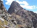
Coal Creek Peak looms above the plains
UN8826 & Scar Top from Crescent
South Boulder and Eldo from UN8826
Thumbnails for uploaded photos (click to open slideshow):
Thanks for posting! I’m planning on doing Eldo and Coal Creek sometime soon. This should help. I did Scar Top from Walker Ranch, and yes, nasty bushwhacking!
What a big day and time spent on the front range! The solitude of this journey would be another benefit to the day. I did an ncar to ncar 13 mile loop earlier this year and really enjoyed seeing the entire flatiron range and its three main summits. I wonder how many mountain lions spotted you with all of that bushwacking
I did the first 5 today. Brought my full backpack, but it took 4:45 to Crescent. And then fell off a bit more and was at 7 hours at Scar tip. Huge route finding mistake where I opted to descent following South Boulder creek instead of returning to my car at the fuller/rattlesnake th in Eldorado state park via the trail from walker. Made it back to my car just under 10 hours.
Nice! If you don’t mind more slightly illegal activity, returning from the Crescent Meadow area along the RR tracks to the top of Rattlesnake is a good option. Bring a light... there’s a tunnel or ... maybe 10?
I just stumbled across this TR. This sounds like a fantastic way to spend a LONG day near Boulder. Thanks for the novel route.
Caution: The information contained in this report may not be accurate and should not be the only resource used in preparation for your climb. Failure to have the necessary experience, physical conditioning, supplies or equipment can result in injury or death. 14ers.com and the author(s) of this report provide no warranties, either express or implied, that the information provided is accurate or reliable. By using the information provided, you agree to indemnify and hold harmless 14ers.com and the report author(s) with respect to any claims and demands against them, including any attorney fees and expenses. Please read the 14ers.com Safety and Disclaimer pages for more information.
Please respect private property: 14ers.com supports the rights of private landowners to determine how and by whom their land will be used. In Colorado, it is your responsibility to determine if land is private and to obtain the appropriate permission before entering the property.


 South Boulder from Eldorado Mtn")
 Eldo Mtn from Coal Creek Peak")
 Coal Creek Peak looms above the plains")
 UN8826 & Scar Top from Crescent")
 South Boulder and Eldo from UN8826")
")