Download Agreement, Release, and Acknowledgement of Risk:
You (the person requesting this file download) fully understand mountain climbing ("Activity") involves risks and dangers of serious bodily injury, including permanent disability, paralysis, and death ("Risks") and you fully accept and assume all such risks and all responsibility for losses, costs, and damages you incur as a result of your participation in this Activity.
You acknowledge that information in the file you have chosen to download may not be accurate and may contain errors. You agree to assume all risks when using this information and agree to release and discharge 14ers.com, 14ers Inc. and the author(s) of such information (collectively, the "Released Parties").
You hereby discharge the Released Parties from all damages, actions, claims and liabilities of any nature, specifically including, but not limited to, damages, actions, claims and liabilities arising from or related to the negligence of the Released Parties. You further agree to indemnify, hold harmless and defend 14ers.com, 14ers Inc. and each of the other Released Parties from and against any loss, damage, liability and expense, including costs and attorney fees, incurred by 14ers.com, 14ers Inc. or any of the other Released Parties as a result of you using information provided on the 14ers.com or 14ers Inc. websites.
You have read this agreement, fully understand its terms and intend it to be a complete and unconditional release of all liability to the greatest extent allowed by law and agree that if any portion of this agreement is held to be invalid the balance, notwithstanding, shall continue in full force and effect.
By clicking "OK" you agree to these terms. If you DO NOT agree, click "Cancel"...
Electric Pass Peak - 13,635 feet
Leahy Peak - 13,322 feet
Distance: ~9.8 miles, including detour to Cathedral Lake.
Elevation gain: ~4000 feet
The Friday night before this hike was one of those nights where you know for a fact that you want to climb something the next day, but no decision is made before 10 PM. When decision time rolled around, the objective became Electric Pass Peak near the popular 14er Castle Peak, just south of Aspen. If I had the time and energy, I would add Leahy to the hike as well. This decision lead to the revelation that living in Eagle County now means the Elks are within daytrip range. Yes!
After some quick research, I was pleased to find out that a nice trail takes adventurers within a couple hundred feet of the summit. I decided that Electric Pass Peak was sufficiently solo-friendly enough for me and got my stuff together in anticipation for an early departure the next morning.
4:30 AM arrived soon, and I was on the road by 5. I arrived at the trailhead shortly before 7. The trailhead is at the end of a short (less than a mile), somewhat rough dirt road which begins about 12 miles down Castle Creek Road from the roundabout in Aspen. There is a small sign for Cathedral Lake at the turnoff.
The trailhead.
I started up the trail a little after 7 and was brought up through the thick aspen forest. It was beautifully lush and green in there! Before long, I reached a clearing where I could see a waterfall ahead and slightly to the left. The trail in this section got a little steeper with some sharp dropoffs toward the creek below, but nothing remotely extreme.
The waterfall, a short way up the trail.
As I passed through more forested area, the aspen trees gave way to spruce trees. The trail then brought me to a large clearing where it crossed an extensive talus field. At the other end of the talus field, I noticed the trail start to switchback up a steep grassy slope, with spruce trees on the left, and steep talus on the right.
"No way it goes up there," I thought. I was bamboozled by this trail! It was super easy-going until now. The switchbacks were several, and they were steep, but they got me up a bit of elevation in no time at all. After the highest one, the trail keeps going to the left, into the forest. Here, I was able to capture a picture of a hummingbird perched on a branch. It may be the first time I have ever seen a hummingbird sitting still.
Looking down the steep switchback section.
Hummingbird.
Shortly after entering the forest, the trail comes to a fork. Left leads to Cathedral Lake, while right leads to Electric Pass. I took a right and soon exited the forest as the trail went up into an area covered by willows, with plenty of wildflowers. The views of Cathedral Peak started to open up in this area.
The trail junction.
Spires on Cathedral Peak tower above.
The only thing I didn't like was the weather. Since I left the trailhead, the sky above and to the west of my location was the only airspace which seemed to have clouds. They weren't threatening, yet, but puffy clouds early in the morning are never a good sign. I decided I would do a weather check every time I reached the next "landmark," so to speak. The sky never got better, but it never got worse either. At first, shortly after starting, I accepted that I may just go to the lake and then back down. Well, I reached the turnoff for the lake, and it still looked relatively okay. I decided I would attempt to summit Leahy first, since it was shorter and the closer of the two to treeline.
A little above Cathedral Lake.
Looking toward Electric Pass Peak (left) and Leahy Peak (right).
At this point, I couldn't stop thinking about how to pronounce this damn peak's name. Is it "lee-hee?" "Lay-hee?" "Leh-hee?" "Lee-hi?" Just "lee?" The English-speaking lady on Google Translate tells me it's "lee-hee." If only I had the cell signal to use Google Translate while I was out there on the peak, I could have saved myself so much internal turmoil.
I proceeded along the trail through the willows with an almost constant watch on the sky, as well as thinking to myself "Thank Jesus there is a trail through here."
Before I knew it, I was at the point where I was thinking would be a good place to leave the trail and hike directly up Leahy. This point is near a south-to-north switchback at about 12,400 feet. There are some small bushy willow areas here, but it is easy to find clearings that lead up Leahy's slopes. I found a nice clearing not too long after the trail turned back to the north.
Looking up Leahy from the point where I decided to hike directly up.
I started hiking directly up the grassy southwest slopes of Leahy, and farther up in my path was a small herd of elk. I didn't expect to see any of those this high up, but they were beautiful. I passed them and continued up the slope at a steady pace, stepping lightly to do as little damage to the tundra as possible. I eventually found a thin, continuous talus band to walk on, which carried me the rest of the way to the summit.
Most of the way up Leahy, looking out across the basin. Castle Peak came into view as I ascended.
Looking toward Electric Pass Peak on the way up the mellow slope of Leahy.
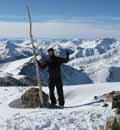
I arrived at the summit of Leahy and checked the time. I had arrived just under two hours after leaving the trailhead! The combination of having a lot of energy that morning plus some anxiety about the weather must have caused me to practically run up the mountain.
I did pause to enjoy the scenery and admire what a beautiful day it still was, even if a little chilly up top.
The view toward the east-northeast from the summit of Leahy.
Electric Pass Peak viewed from the summit of Leahy.
Cathedral Peak looking impossible.
Pearl Mountain (left) and UN 13,312 (right).
The weather looked the same. I decided the next "checkpoint" would be where the Electric Pass trail meets the saddle between Electric Pass and Leahy Peaks. The gentle, grassy descent to the saddle brought me through various types and colors of rock. First, there were large red blocks, resembling the rock found on the Maroon Bells, sticking out of the grass in various spots. Then there was an area of purple-colored rock. Lastly, a small point composed of small beige-colored rocks greeted me just before hitting the trail at the saddle.
A bit of a color gradient.
The weather still looked the same. Not bad, but not exactly great either. I decided I would just push hard to get to Electric Pass Peak's summit, then make a quick descent to Cathedral Lake. Then, I kid you not, not two minutes after starting up the remainder of the trail toward the summit, the sky to the west cleared. Yes! I continued upward. I stopped to look back down the trail and noticed a few runners heading up my way, with a couple of hikers ahead of them. People run up this thing?!
Looking back toward Leahy.
The trail switchbacked up along the ridge before cutting directly across the southwest face of the peak. The terrain here got steeper with more loose dirt and scree. Not steep enough to tumble down, but enough to be tedious. This part was short-lived, though, and after a couple more minutes, I was at the top of Electric Pass - not the peak, but just the pass itself. Here, Pyramid, part of the Maroon Bells, Snowmass, and Capitol all came into view. I love the Elks...
Crossing the talus/scree slope toward Electric Pass (the pass itself).
The final section of the hike to the summit from the top of the Electric Pass trail.
Looking back toward Leahy again, with the trail and some hikers in view.
The summit was not far from here. The trail didn't completely end either, as a social trail lead me the last 100 feet or so to the summit. I arrived at the summit, feeling absolutely incredible, and sat down for a little break. I gazed at the northern Sawatch, the Gores, to Cathedral and Castle, and then to the rest of the Elks to my northwest. What a beautiful summit!
Mighty, mighty Snowmass and Capitol from the summit.
Normal, zoomed-out view looking northwest up the Elks.
Castle Peak (left) and Cathedral Peak (right).
Looking back down the basin toward Cathedral Lake and beyond.
Looking toward unranked 13er Hayden Peak, with lower terrain surrounding the Roaring Fork Valley in the background.
Maroon Peak in the light; Pyramid Peak in the dark.
I ate a little snack, drank some water, took plenty of pictures, and got ready to head back down. The weather was still better than it had been since I left the trailhead. However, there was a small, but dark-bottomed cloud to my west-southwest, several ridgelines over. I was going to make a quick descent anyway, but the decision was reinforced. I thought to myself, "I bet this is going to be Mt. Hope, Part 2." If you were on Hope with me last year, you know what I mean!
I descended back to the top of Electric Pass, then made my way back across the face toward the opposite ridge. Upon reaching the ridge connecting to Leahy, the trail again became well-graded and nothing but enjoyable. I could see people making their way up and down the smooth switchbacks to the basin floor, half of them running. Seeing how that one cloud had gotten bigger, I decided to start jogging down. I'd fit right in!
The cloud developed rapidly as it moved over and the weather became gloomy. The jogging, even downhill at an only slightly steeper-than-optimal grade, was tiring at this elevation and with weight on my back. By the time I got to the basin floor, graupel was falling, and I pushed onward toward a junction with a spur-trail leading to Cathedral Lake. Throughout it all, there were people heading up, un-phased. The shower was pretty weak though, without a single clap of thunder. By the time I got to the junction (not the main trail junction, but a different one above the lake), the shower had passed and the sky was completely clear. Of course!
The shower passing through.
The sun was out, and the wildflowers were glistening. I took plenty of pictures of the abundance of Indian Paintbrushes.
Pretty pink flowers.
A forest of Indian Paintbrush surrounds the trail.
And then a cluster of them!
I don't know what these are called, but I'll call them "purple pricklies."
I made my way down to the lake for a relaxing break. It's a quick detour from the main trail and I would highly recommend taking a break there to anyone climbing the peaks in the area. I put my feet in, but that was nothing compared to the guy near me who walked in almost to this waist.
Cathedral Lake.
When the weather started to get cloudy again, I packed up and made my way back down the Cathedral Lake trail toward the junction. I re-joined the Electric Pass trail and made my way back to the trailhead, stopping to look at the pretty flowers every once in a while.
The spires of the Cathedral.
Daisies and aspen trunks.
Upon reaching the trailhead, it started to sprinkle again, and by the time I was on Highway 82 headed out of Aspen, the wind was blowing ferociously and the mountains to the southwest were just covered in white and grey. I sure got out of there in time.
My times for the day, at a faster pace than my normal:
Overall, a fantastic hike of two 13ers. I highly recommend Electric Pass Peak, as it is easily attainable and has fantastic views. Heck, add in Leahy too, which I would also say is a great introduction to off-trail hiking. I'll definitely be back.
~Tony
Thumbnails for uploaded photos (click to open slideshow):
Just did this exact same trip on 7/12 including lake visit (~6hrs too). Amazing views from Electric Pass. Your pics of the flowers are great. I went directly up the E ridge of EPP from Leahy (maybe 1 class 3 move, otherwise straight–fwd, although very windy & exposed in places), and came down the S ridge. I didn’t like the scree trail across the S face so much – not well maintained, and potential for rock fall from above. Nice to visit the lake too and get a good look at the Cathedral couloir route.
I was up there on 7-9-15 with fresh snow from the night before! I hiked the same loop with Leahy 1st & EPP 2nd. Nicely written report; but I should mention that pic25 is of Hayden Peak, not Hunter. Did you shortcut over Cottonwood Pass Road (not the one by Yale, the one by Gypsum)? To compare the difference 2 days can make - view my album here:
http://www.facebook.com/brad.hulslander.1/media_set?set=a.423207744549021.1073741906.100005793962815&type=3
Tony, this is awesome. I may be out in Snowmass in September, so these may have to be on the list. Thanks for the info!
Favorite lines of this TR: "If only I had the cell signal to use Google Translate while I was out there on the peak, I could have saved myself so much internal turmoil." – Been there man. Sometimes the only thing between you and having a good time is some good ole’ fashioned information! No cell service on the peaks?? What are we in, the dark ages??
Glad you didn’t have Mt. Hope, Round 2. Glissading EPP looks a little more rocky.
You just added some more peaks to my to–do list. So many mountains, so little time. Gorgeous summit views from the looks of it. Thanks for posting !
Caution: The information contained in this report may not be accurate and should not be the only resource used in preparation for your climb. Failure to have the necessary experience, physical conditioning, supplies or equipment can result in injury or death. 14ers.com and the author(s) of this report provide no warranties, either express or implied, that the information provided is accurate or reliable. By using the information provided, you agree to indemnify and hold harmless 14ers.com and the report author(s) with respect to any claims and demands against them, including any attorney fees and expenses. Please read the 14ers.com Safety and Disclaimer pages for more information.
Please respect private property: 14ers.com supports the rights of private landowners to determine how and by whom their land will be used. In Colorado, it is your responsibility to determine if land is private and to obtain the appropriate permission before entering the property.


 and Leahy Peak (right).")


 and UN 13,312 (right).")


.")


 and Cathedral Peak (right).")


 The trailhead.")
 The waterfall, a short way up the trail.")
 Looking down the steep switchback section.")
 Hummingbird.")
 The trail junction.")
 Spires on Cathedral Peak tower above.")
 A little above Cathedral Lake.")
 Looking toward Electric Pass Peak (left) and Leahy Peak (right).")
 Looking up Leahy from the point where I decided to hike directly up.")
 Most of the way up Leahy, looking out across the basin. Castle Peak came into view as I ascended.")
 Looking toward Electric Pass Peak on the way up the mellow slope of Leahy.")
 The view toward the east-northeast from the summit of Leahy.")
 Electric Pass Peak viewed from the summit of Leahy.")
 Cathedral Peak looking impossible.")
 Pearl Mountain (left) and UN 13,312 (right).")
 A bit of a color gradient.")
 Looking back toward Leahy.")
 Crossing the talus/scree slope toward Electric Pass (the pass itself).")
 The final section of the hike to the summit from the top of the Electric Pass trail.")
 Looking back toward Leahy again, with the trail and some hikers in view.")
 Mighty, mighty Snowmass and Capitol from the summit.")
 Normal, zoomed-out view looking northwest up the Elks.")
 Castle Peak (left) and Cathedral Peak (right).")
 Looking back down the basin toward Cathedral Lake and beyond.")
 Looking toward unranked 13er Hayden Peak, with lower terrain surrounding the Roaring Fork Valley in the background.")
 Maroon Peak in the light; Pyramid Peak in the dark.")
 The shower passing through.")
 Pretty pink flowers.")
 A forest of Indian Paintbrush surrounds the trail.")
 And then a cluster of them!")
 I don't know what these are called, but I'll call them \"purple pricklies.\"")
 Cathedral Lake.")
 The spires of the Cathedral.")
 Daisies and aspen trunks.")