Download Agreement, Release, and Acknowledgement of Risk:
You (the person requesting this file download) fully understand mountain climbing ("Activity") involves risks and dangers of serious bodily injury, including permanent disability, paralysis, and death ("Risks") and you fully accept and assume all such risks and all responsibility for losses, costs, and damages you incur as a result of your participation in this Activity.
You acknowledge that information in the file you have chosen to download may not be accurate and may contain errors. You agree to assume all risks when using this information and agree to release and discharge 14ers.com, 14ers Inc. and the author(s) of such information (collectively, the "Released Parties").
You hereby discharge the Released Parties from all damages, actions, claims and liabilities of any nature, specifically including, but not limited to, damages, actions, claims and liabilities arising from or related to the negligence of the Released Parties. You further agree to indemnify, hold harmless and defend 14ers.com, 14ers Inc. and each of the other Released Parties from and against any loss, damage, liability and expense, including costs and attorney fees, incurred by 14ers.com, 14ers Inc. or any of the other Released Parties as a result of you using information provided on the 14ers.com or 14ers Inc. websites.
You have read this agreement, fully understand its terms and intend it to be a complete and unconditional release of all liability to the greatest extent allowed by law and agree that if any portion of this agreement is held to be invalid the balance, notwithstanding, shall continue in full force and effect.
By clicking "OK" you agree to these terms. If you DO NOT agree, click "Cancel"...
Dates: June 17-19
Trailhead: Crystal (Lead King)
Mileage: 19
Elevation Gain: 9,484'
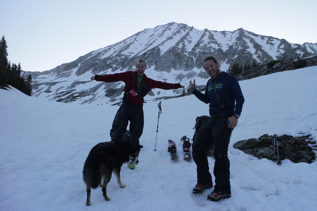
Partners: Joel and Zach
Joel and I have been discussing going in from the west for Snowmass and Hagerman since spring 2014. It was back on the docket for this year again. We even planned it out for the first week of May. But that's when the weather took that even more wintery turn. So we put it off a week. Maybe it will be better. Then we pushed it off another week, and another. For a month and a half, we had this duo planned, and unplanned. Not exactly the easiest way to plan ones spring! So this time, it was going to happen. We just had to hope for clear skies and maybe a bit of a breeze to help us out on a solid freeze.
Met Zach at the Dino Lot and we took his SUV, as I was a bit worried about taking my truck on a road that I had very little beta on. I knew the road after Crystal got rough, but I didn't know how much. Figured for a mile and a half, it wasn't worth possibly getting it stuck or damaged. Joel was a few hours ahead of us, and set up camp before us, as we were just arriving to start the hike. I had hoped to start the hike at about 6pm, but somehow 7pm was our start. The hike up was fast punctuated with super slow, as in many places the road was a raging river, and we took off our shoes and socks at least 3 or 4 times on the way up. My country girl self was laughing at my suburbanized feet. I used to never wear shoes growing up, and could handle sharp pebbles underfoot with ease. Living in the Front Range has softened my feet incredibly, and for all those stream crossings, I wish I had brought my flip flops.
We got to camp after dark, and Joel led us into where he was via headlamp, until he met us along the postholed trail. Being a short night, Joel immediately went back into his tarp tent to sleep, while Zach and I ate and got our camp set up.
Sunset on Snowmass and Hagerman
After a few hours of disturbed sleep, as I was on a slight slope, we were on the way up valley. We scouted a more direct route up to the face, but ended up having to go around, as the stream crossing was too much lower in the valley. Snow was still patchy at this elevation and slowed us down. Once back near the summer trail, we neared the base of the route, where we could see another group ahead of us. Interesting for a weekday! The cliffy area around the waterfalls was melted out, but that was all. The other group went up a more challenging route to the lookers right of the waterfalls, where I lead our group up the route that I remembered descending back in 2009.
The lower apron was filled with huge avy debris, and was hard as a rock at this point. Wasn't looking forward to skiing down this, so hopefully we could find a slightly different way on the descent. We found trail sections within the loose rock, once we left the snow. But soon we just traversed into the center gully above the overhanging waterfall cliff section. Steep firm and narrow through this section as we made our way up, through a super icy runnel and over onto a smoother snow gully to lookers right of the summit. We tried to find the boot prints of the group ahead of us, but since they had passed this section before a sun hit, their crampons made little impression. So we made our own booter. The lack of sleep caught up to Zach and me, and while we traded leads most of the way up the peak, Joel had to finish strong for us, as we both tapered near the end of the climb. The solar cooking also sapped what energy we had left.
Right below the summit, we met the other group and asked them about their route, and told them to follow our steps for the easier descent. From there it was just an internal race to the summit, before the snow went from money corn to slop.
Be careful who you go into the woods with...
First view of Snowmass Rough lower debris fan Avy fan up to the rock cliffs Joel climbing until the snow runs out Joel climbing above the waterfalls Zach with Siberia Peak behind - about to cross the icy runnel Joel leading up our ski gully Zach coming out of the traverse
Didn't spend much time on the summit. Just snap a few photos, drink something and transition. Since we had to ski the ridge for a bit, the snow was quite soft already, and we just wanted to get down to the good corn below. We only had a couple rocks to manuever around, a lot more snow than when Mike was here earlier in the season. From there it was a couple steep turns before it mellowed out to a nice 40ish for the majority of the snow gully. Pretty perfect corn was had!
Pyramid and the Bells Hagerman and it's impressive summit ridge cornice Capitol - the other white Elk 14er
Zach about to ski Snowmass
Joel and Max Zach riding past Joel slashing some snow Joel skiing past Zach riding by
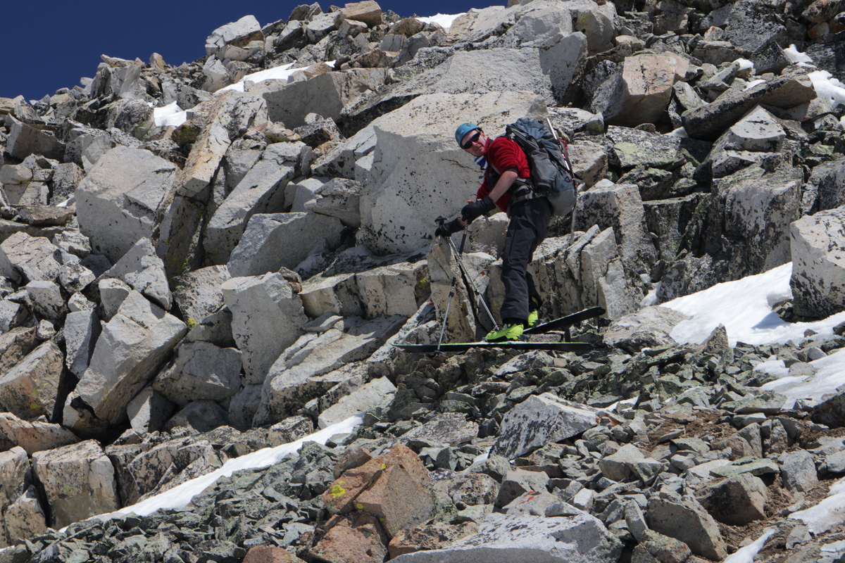
After traversing back into the main gully, the icy firm snow from the early morning had given way to nice corn. So what was steep and rather intimidating on the way up, was actually quite skiable. Until we got to the rock cliffs. Then it was a dry descent for a short bit, before we could get down the lower apron. Joel spotted a cleaner line to skiers right, so we traversed over and enjoyed non-slid smooth snow all the way down into the stream valley below.
Zach contemplating the steep exit above the waterfalls
Finding a better route below the rock cliffs
Looking back at our climb and ski
Once back in camp. We relaxed and ate and napped, until we could justify going to sleep. Not one of us is ashamed to say we were asleep before the sun set. I couldn't keep my eyes open, despite the great view.
Hagerman reflections Snowmass and Hagerman from camp
Too bad I can't keep my eyes open for this view from my bivy tent.
Day 3: Hagerman
This morning, we got up earlier than previous, since we would be skiing a solar line and we also wanted to get out of the basin early, if we could. But first we had to cross the swollen stream that feeds Geneva Lake. In the dark it wasn't easy to find the shallowest section. But we found a spot that looked fairly ok to my geoscientist mind. The water was ridiculously cold. And then it went over the knees soaking my pants and everything I had rolled up to try and keep dry. Once on the other side, to add insult to injury, we now had to climb a bank with icy snow on it in our bare feet. To say our feet were screaming at us would be an understatement. This was not pleasant at all. I hoped the return wouldn't be as bad.
We skinned up to the ridge and found the dry trail, where we booted to the base of the route on Hagerman. From there we skinned and then eventually transitioned to crampons up a hill before the face itself. From that hill we had a great view of our objective. We could see that snow went straight up to the summit on lookers left, but that the snow was of a better quality over to the lookers right of the face. So we decided to go up to the left and then come down on the right.
Bear print!
Treasure Sunrise Approaching Hagerman
The whole lower part of the face had slid in a monstrous way, probably only a couple days ago. Found a couple steep and super icy firm sections before we got up into the sun on our intended ascent route. From below it looked like we could sneak around a ridge cornice in one spot, and I lead to that point, but when Joel got there, he didn't like the snow. I didn't like the route below us, around the cornice, onto the ridge. So we decided to do a high traverse and cross into another gully with snow to the summit ridge.
Huge slide debris Starting up the steeper stuff Joel leading up the western side of the face Looking up at the summit and a undulating snow line Joel traverseing into another snow chute Joel and Zach nearing the summit ridge
We got to spend a bit more time on the summit today, than we did yesterday, as the sun had only just started to hit the line we wanted to ski. So we perched on the tiny summit for a while, before deciding to ski down the ridge and over to the top of our line. We just had to be super careful of the cornice we knew was under our feet. Joel kept his skis on the most, but he also doesn't have new ones like me.
Snowmass!
The Bells
Zach with a (snow)mass between his legs.
Joel skiing next to a cornice hole...
Joel rock skiing
Once into the desired snow chute, the snow was pretty good up top, but then quickly got thick down below. We had talked about traversing back to the center of the face to descend what we came up. But decided that going further east into the other drainage, and then following it back to the trail and the starting point below would be smoother and more quality than safety skiing avy grundle. (Note my GPS somehow got turned off for this descent - so it won't show our route)
Joel enjoying the corn Joel flying past Zach kicking up some snow Zach below Looking back up at our eastern line on the south face Joel skiing down drainage Looking back on Hagerman from the lower trail
The snow was pretty continuous all the way down the drainage, till the end. I decided to do a 10' climb out of the stream valley so that I could get a continuous slide all the way out. While Joel and Zach continued down further and then had a flatter traverse out.
On the transition to trail hiking, I was entertained by Joel and Zach in the video I will put below. But I first have to beep out their bad language... Don't know why, but Zach sounds like a Canadian!
The Bells and Fravert Basin
Little lake along the trail back to camp
The stream crossing was much easier and even slightly enjoyable on the return. Was able to find a shallow yet wide section of stream that didn't go over my calves. Then traversed along a beaver dam to the other side, where putting the skis back on prevented postholing.
The stream crossing - in daylight
Back at camp, we had some drama as Zach couldn't find the car keys. But after the second time checking his sleeping bag, he found them. I packed my day pack a bit more efficiently, but that meant that I couldn't get both skis and boots on my pack in the normal configuration, so I had to take one boot off a ski and strap it next to the skis. After a bit of experimentation, I got it all to stay put. Not bad for a 38L pack!
After finding the trail to the cliff next to the waterfall, we get back on trail and hauling tail down the basin. I can hear my grandmother now - haste makes waste! I was wearing trail runners, no ankle support. Gotta save that weight, right? Well, about a half mile from the 4WD trailhead, my left ankle rolls more than 90 degrees and I hear a loud pop. It was louder than the babbling stream right in front of me. The instant it happened, I had flashbacks to when I broke my leg last June. No - Not again! The pain wasn't nearly as bad, and it was over in an instant. Oh, it still hurt like you know what, but it was tolerable. Of course me yelling for Joel and Zach probably sounded pretty shrieky, since they were just a little bit ahead of me at that moment.
I dropped to my other side and got my pack off. I almost expected to see my ankle all mangled, but it was there in a normal position. Zach got to me quickly and did an assessment. Glad to have an ICU nurse and mtn rescue guy on the team now! He told me he would be bringing a full medical kid with him, and here he got to use some of it. While Joel ran down the trail to drop his gear off by his bike and trailer (brilliant call), so he could then bring my gear out the short distance, I put my ankle into the little icy cold stream next to me for about 30 minutes. At the time, most of my pain was where I sprained the ligaments in my ankle, and not much where my fibula is, so Zach didn't think I had broken it. Now with an x-ray, I did fracture the lower part of my fibula, at the ankle. Who knew an ankle roll could break a leg!?
I had the choice of: use my SPOT - again, or hobble out on my own power. With Joel carrying my gear on his bike and trailer, I figured I could hobble out with my trekking poles. So Zach taped and then wrapped my ankle, and I made my first tentative steps. So far, so good. My ankle stability seemed pretty good, so maybe I didn't completely tear my ligaments. Hoping for just a class 1 sprain, but it's likely a 2, with some serious damage - again. Same ankle I had a class 2 sprain over a decade ago.
After the short distance on the trail, it was all downhill road walking. Zach had to help me across one raging stream, acting as downstream support so I didn't have to. Had to walk across in my trail runners. No getting cute taking them off to avoid getting them wet. Without the weight, I was able to keep a decent walking pace. So fast, we both were wondering where Joel was. How could I be beating him downhill, when he has a bike? About halfway down, he caught up and has and ATV in tow. Mark and his friend Mark, then graciously give me a ride back down to Zach's vehicle, so I can save my ankle. Amazing the people who are willing to help with little thought! Of course, he now has a story to tell of the time he rescued a lady with a busted ankle who just skied that cool mountain up there
From there it was a horrible drive out down that rough road. I could tell Joel was getting tired, when he stopped and threw a tiny rock into the stream from the road. Like that was going to help. Or when he mouthed "I hate this road", back at us. He busted one tire rim on the way in, and we saw him bottom out on a rock at least once on the way out. This road is not easy soccer mom SUV terrain.
Once we got to Marble, we hit up their BBQ joint and got treated to some live music as well. I almost made it through my pound of delicious brisquet! Then just the long drive home.
How an engineer makes an overstuffed pack work! Waterfalls!
Zach taping my ankle
View from the ATV
Joel actually riding the bike...
So after seeing the doctor last week, it seems I have about 6 weeks of recovery - in my stupid boot again. After going through the broken bone swelling and bruising phase, which has kept me with my leg elevated, I'm back to light walking already. Not exactly what I wanted to happen, but then it could have been worse - again. So hopefully I won't be out of the mountains for too long this time. Already got new boots with ankle support ready to go. Guess light weight trail runners are just not good for me.
My GPS Tracks on Google Maps (made from a .GPX file upload):
over the scenery. Such incredible mountains and tough lines. Kudos to you and your partners for getting it done. Bummer about the leg, but at least it was on the hike out. Heal up soon – I’d love to get out with you again! Cheers.
Well done, glad you’re all getting after it this year!
Caution: The information contained in this report may not be accurate and should not be the only resource used in preparation for your climb. Failure to have the necessary experience, physical conditioning, supplies or equipment can result in injury or death. 14ers.com and the author(s) of this report provide no warranties, either express or implied, that the information provided is accurate or reliable. By using the information provided, you agree to indemnify and hold harmless 14ers.com and the report author(s) with respect to any claims and demands against them, including any attorney fees and expenses. Please read the 14ers.com Safety and Disclaimer pages for more information.
Please respect private property: 14ers.com supports the rights of private landowners to determine how and by whom their land will be used. In Colorado, it is your responsibility to determine if land is private and to obtain the appropriate permission before entering the property.


mass between his legs.")


 Sunset on Snowmass and Hagerman")
 First view of Snowmass")
 Rough lower debris fan")
 Avy fan up to the rock cliffs")
 Joel climbing until the snow runs out")
 Joel climbing above the waterfalls")
 Zach with Siberia Peak behind - about to cross the icy runnel")
 Joel leading up our ski gully")
 Zach coming out of the traverse")
 Pyramid and the Bells")
 Hagerman and it's impressive summit ridge cornice")
 Capitol - the other white Elk 14er")
 Joel and Max")
 Zach riding past")
 Joel slashing some snow")
 Joel skiing past")
 Zach riding by")
 Zach contemplating the steep exit above the waterfalls")
 Looking back at our climb and ski")
 Hagerman reflections")
 Snowmass and Hagerman from camp")
 Approaching Hagerman")
 Huge slide debris")
 Starting up the steeper stuff")
 Joel leading up the western side of the face")
 Looking up at the summit and a undulating snow line")
 Joel traverseing into another snow chute")
 Joel and Zach nearing the summit ridge")
 Snowmass!")
 Zach with a (snow)mass between his legs.")
 Joel enjoying the corn")
 Joel flying past")
 Zach kicking up some snow")
 Zach below")
 Looking back up at our eastern line on the south face")
 Joel skiing down drainage")
 Looking back on Hagerman from the lower trail")
 The stream crossing - in daylight")
 How an engineer makes an overstuffed pack work!")
 Waterfalls!")


