| Peak(s): |
Mt. Wilson - 14,256 feet Pikes Peak - 14,109 feet "Middle Point" - 13,266 feet |
| Date Posted: | 04/09/2015 |
| Date Climbed: | 04/04/2015 |
| Author: | bergsteigen |
| Additional Members: | Gueza |
| Peak(s): |
Mt. Wilson - 14,256 feet Pikes Peak - 14,109 feet "Middle Point" - 13,266 feet |
| Date Posted: | 04/09/2015 |
| Date Climbed: | 04/04/2015 |
| Author: | bergsteigen |
| Additional Members: | Gueza |
| Humility, Redemption, BetaB's, and Gaping in the Sad Juans - Plus Pikes Peak or Dust! |
|---|
Mt WilsonTrailhead: Cross Mountain Mileage: 11 Elevation Gain: 5,110' Chunky Ice Scrapers: Eric and me The Wilsons... every time I've come here, it's always been an adventure. A painful adventure. Bruised, battered, ego shattered and otherwise mentally drained. I was hoping for better this time. Moneymike said Mt Wilson was skiing great! He sent some beta on Wilson Peak. Thin, but I'd entertain the Coors line, with NW as backup. El Diente - well we'd see how much snow there would be for the Mohagany. Dr Wilson was my undergraduate geophysics advisor. It would be cool to say I skied "his" peaks next time I saw him. He always tried to get me to go ski the high peaks in the Adirondacks in winter. I thought that was crazy at the time... Simple logistics too. 3 days, 3 peaks, refuel in T-ride. Eric even let me drive the carpool so I could have CasaSubi, while he tent camped. So on the drive down to pick him up, I finally got my Thule Box, and made the stop-n-go drive down to a park n ride in COS, where I looked up at Pike's east face. Long drive out to T-ride, punctuated only by the annoyances of having an old beater Subi. Seems like a plastic flap was coming lose on the outside, and was making the car sound like HeliSubi. Some pink duct tape at the next stop, no more flapping! The almost full moon lit our way to the trailhead, and got Eric all excited for the next day. I just wanted to go to sleep, it would be a short night. A few hours later, we were skinning up the well used trail. At about 11K we left it and started the fairly easy bushwack into the proper drainage. Eric was following glimpses of tracks. Were they pennies from MoneyMike? Or from some other skiers. We just hoped they were heading where we wanted to go. After dropping some elevation, we exit the trees and see our prize. It would have been nice to wait there for sunrise, but it was fairly chilly this morning, so we kept going.  We had some wind to go with the chill of a deep freeze overnight, so we knew we had plenty of time to summit. The sun rising over the ridge behind was a welcome warmth bringer, and made things feel ever so much more hopeful. From this vantage point it can be difficult to decipher which ridge bump is the summit - but it's really the obvious one at the direct end of the drainage. Eric kept skinning up the firm icy slope, whereas I switched to crampons and booting. Less effort, not slipping with skins would help for 3 days of this, I thought. After the first steep slope, Eric also transitioned for the final push. Footprints went to the left (south) of the summit, so we followed along.   Cool view of Lizard Head    Climbing the left branch - Photo Credit Eric We knew from Mike, that there wasn't continuous snow from the summit. There rarely is. So at the high saddle, we take off our crampons and turn the corner to find a nasty loose gully to the summit. The initial part is the worst. Just loose crap on other loose crap. Nearing the summit, it gets better, but also harder. I found the last moves to be class 4, since I'm short. But you may be able to keep it class 3 if you're taller.   We enjoyed the summit for a while. The last 2 times I was up here, I was either racing darkness or a storm, so my stay was brief. The views were great, and it was nice to soak them in for a while. Too bad the views of Wilson Peak were soul crushing. It looked dry, very dry. Fears of a melted out NE face were now on my mind. Looking at the south faces of the 13ers to the north was even more disappointing. The south facing line on El Diente was likely a white thong of death right now. To me the Fox was saying a big ol Nope too.       With as warm as we felt on the summit, as well as how late it was, there would be just about as much warming as we'd likely get for the day. I was hoping it would be enough for some lovely forgiving corn. So we scrambled back to the top of the line and got ready. Eric dropped it first. Hmmm a bit icy. As I went, it was still quite firm, but I hoped it would improve as we got lower down, and away from the worst of the wind at the saddle. Unfortunately, it didn't improve. So I sought out the smoother areas of snow, and made my way down. It hurt quite a bit, as it was hard and icy. Met Eric over in the middle of the basin on the way to the top of the Boxcar, where we just chilled for a bit. Let it warm a wee bit more...   Me skiing down Mt Wilson's bowl - Photo Credit Eric  After a bit of a break, we skied over to the top of the Boxcar, where we could still see the side stepping from the week previous. Uggg. In that narrow entrance, I could see why they did that. But it totally crapped our day, since the snow was still quite chilly. After a bit of contemplation, we both decided to go for it. Eric only made a couple more turns than me, so I don't feel quite so bad for my slow rough entrance into the aesthetic couloir.   After the choke, conditions improved, a bit. The skiers left side was warm enough to be enjoyable (if it wasn't for the ice debris and slashtastic remains of the previous skiers), while the right side was still quite firm and icy. We made our way down as best we could. The couloir felt longer than it was, just because linking too many turns together wasn't really possible for me. I'm quite comfortable on 45-50 terrain, when conditions aren't horrific. The slashed and trashed slope was an icy disaster. One jump turn ended in me slamming my left shin into a giant ice chunk. That was painful. The exit out of the couloir was also side scraped to death, and in the shade now, so that was a slow go for both of us as well. I had even hoped the lower apron would be lovely corn, but I only got a couple good turns before it went icy again. Traversing more left, I found the corn I was looking for, and tore it up to where Eric was waiting. We were both glad that couloir was done!   Me skiing the upper Boxcar - Photo Credit Eric   At least the views are spectacular - Photo Credit Eric 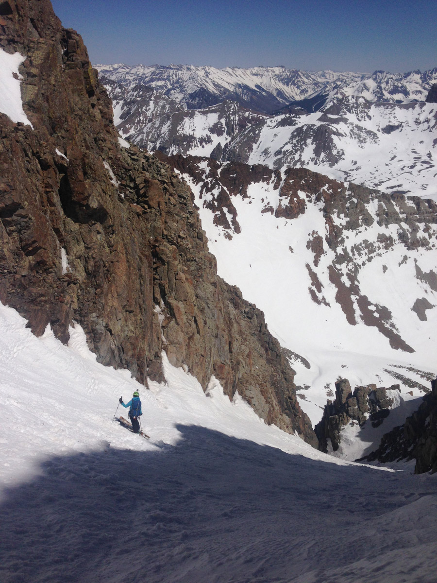 Evil shadows - Photo Credit Eric Once on our way down to the bushwack back to the car, we got the corn slope we had hoped for higher up. Both of us tore it up as hard as possible, to make up for the previous sub-par ski. From there it was a matter of climbing up and then traversing back to the trail. At least the cooler temps kept the lower snow from being a nightmare. Small victories!   Corn, glorious corn!!! Eric tearing it up. Pt 13,300ETrailhead: Ophir Pass road - base of line! Mileage: 3 Elevation Gain: 2,603' Lazy Corn Seekers: Eric and me So after deciding the other 2 Wilsons were now OUT, and suicidal without a lot more snow, we had to come up with plan B while eating dinner in T-ride. We both wanted something else in the Sad Juans (as I'm now calling them for the 2015 skimo season). We went through Eric's list of SJ's that he needed. But there wasn't any beta on Yankee Boy Basin in a while, or for Grizzly Gulch. Neither of us wanted anymore BS approaches and long slogs. Something simple and fun, with lots of corn. Since 14ers didn't seem like a good plan, it was time to wrack my brain for 13er ideas. A friend is working at Silverton this season, so I checked out what he had been doing lately. And came up with Kendall Mountain, just at the edge of town. His photos made it look good, and the exit didn't look horrific. I had wanted Grand Turk to Sultan connection, but with a shuttle required and my friend not even being available till 4-5pm at the earliest, that was out. So we made the long drive to go a short distance to Silverton for the night. Next morning, we get up early and notice something really odd about the moon. It was eclipsed! Huh? I didn't realize that was happening tonight! I was so startled and confused, I didn't take a photo. We drove into town, and tried to find the entrance to Idaho Gulch. From one direction, I found avy debris over the road, so I had to go around to the other end to find the start. At this point, civil twilight was about to begin, so we decided to drive a bit further out to get a better view of the route. That's when we realized how much snow had melted in the past week... the exit looked - unpleasant. On to Plan D now? I'm losing track. Let's drive up to Red Mountain Pass as see what looks good. On the way up Eric spots something he gets excited about. With me driving, I wasn't able to gape as much as him. So what I saw looked ok, but kinda boring. At the pass, neither of us was very excited about what we saw nearby. So down to Ophir Pass road. Thankfully he convinced me to drive further to spot the line he was talking about. Soon as I saw it, I also had a dreamy look on my face as well. Mmmm that would corn up nicely!  So I started down the Ophir Pass road and after the bridge saw two trucks parked at the side next to the high clearance 4x4 sign. Hmmm should we just park it here and walk the mile or so? The next part of the road didn't look terrible, but I was worried about farther, as well as places to pull out. I didn't want to be the SubiBlock on the road. So we geared up there. Eric started up first, as I was finishing gearing up. I started up the road, taking some gaper photos of nearby peaks in the rising sunlight, mostly with my head down. Soon I saw Eric without a pack coming quickly down the road at me. Hmmm what did he forget? According to him, the road got so much better, that we could drive. We had forgotten 4x4Subi. Drop pack, get Subi. We ended up driving to the base of the line, where there are a couple nice pullouts. Brilliant! Easy breezy day to be had!     It was an easy booter all the way up to the summit. Eric still had a ton of energy, so I let him run up the slope. I was content to keep a lazy pace, since we were still early for the corn harvest. No need to rush. The views were incredible. So many lines to come back for. I was practically drooling I was gaping so hard. The summit had one of the best 360 degree views I've seen in a long while. So I made Eric get out of the way, while I spun in a circle with my camera. Oh my! The summit pitch even had a fun little scramble among the loose Sad Juan scree.     Weminuche! After soaking in the amazing views, we scramble back to our stash, and hang out, waiting for the snow to ripen. As we wait, we note 6 other skiers coming uphill! Wow, popular place! We definitely chose well today. Plus we'll drop first, and get the best lines. No slop / chop/ or icey crap! Once the snow was ready, we started down our respective lines. I went a bit more solar, but it left with a great camera angle on Eric as he dropped a steeper line on the ridge line. From there, we both just tore down the corn snow slope and thoroughly enjoyed ourselves. Eric just saw the light at the end of the 14er ski project... great 13er lines!     Eric catches a bit of air  Eric realizing how fun skiing 13ers is! Once at the bottom of the main slope, we just had to pick an exit line. A few require a dry traverse, but Eric found a route down that was snow to the road. Simple and beautiful way to get redemption after a rough day on Mt Wilson the day before!  After drying out at the base, we started the drive to Monarch Pass. We were planning to ski Aetna's Grand the next day. It's a classic line every skier should do eventually, just because. But as we crested Monarch Pass, we saw something sad. It was out. Not fully, but enough that the snow wasn't continuous. Uggg what a rough snow year. With that disappointment, Eric wanted to go home and do college and family things on Sunday instead. Can't say I blame him. Guess I'll finally go hit up the east face of Pikes tomorrow! Plan E? I don't know anymore!  Pikes PeakTrailhead: Pikes Peak Road Mileage: 10.4 Elevation Gain: 3,158' Earning our Pikes Peak Ski: Rick and me Simple plan. Drive to summit. Wait. Ski down. Boot up. Drive home. Easy right? Eric said the road was open at 6am. Others have said the road is typically open to the summit as well, just not after storms. So I got there about 8am. Don't need to rush this one, I'll just be waiting. I get to the entrance gate. It's deserted. No one! Hmmm. After some googling, I find out the road opens at 9am. Fine. I'll just relax in the sun as I wait for the employees to show up and open the gates. Once open, they say the road is only open 15 of the 19 miles. Hmmm, guess I'll have to work for it today. Not like I can drive and ski somewhere else at this point, it's late! I drive up to the "end of the allowable road" and turn around and go back to where I saw another truck full of skiers/climbers. I hated losing that elevation, but I wasn't going to park in tourist grand central station. Plus lower down, would at least have a fun exit ski. There a guy named Aaron comes up to ask if we can ski the snow he sees. He's fresh from Jersey and has his snowboard in the back. I say that's my plan! I then cheekily ask if he'll give me a ride up to the "end", to save about 500' of gain. He agrees. Rick in the truck next to me also perks up at this suggestion and so we both clamber into Aaron's truck and drive up as far as we can. Here the ranger tells us that we can not walk on the road, at all. So I ask, can I walk just below the switchback, and go over to the snow and climb. Yes you can, is the reply. Ok... let me erode a slope instead of walking on a road. Gotcha. Whatever! Rick's a New Mexican in the Air Force and was looking to ski his first 14er. He's been perusing this site trying to find a good option. He settled on Pikes, since he thought it looked easy enough. He asked to tag along, and I thought as long as he can keep up, and doesn't get frightened off by the view of Pikes from the road (which looks farther away than it is), he'd be welcome company. Well true to form, the young guy kept out in front of me on the road - uhhh - trail, all the way up until the end where I knew of the shortcut (ie trail) and beat him to the summit proper.    At the summit we meet a couple that passed us on the last switchback up. They offered us food, so they wouldn't have to carry it back down. Once he said the cookies were gluten free - he gave me two. Mmmm cookies on Pikes without cookiehiker, not bad! The wind was howling so bad, I put on all my layers while sheltering from the wind by the building. Here is where I listened to an guy excited for his first 14er ski. When we looked down the east face line, he thought it was further right. So we went and investigated, using valuable time. The line looked quite tasty, but it cliffed out and it looked like a horrific climb back up. So I said nope, and we reclimbed back to the top and dropped the east face line.   The line held just about every type of snow. Breakable crust, hardpack, powder and even a smidge of softish corn like substance. I kept an eye on my altimeter watch, and called the descent at about 1K. That should cover any and all BS skiing down the road to get a true descent (yeah I'll be back for the Y eventually)     Rick had just bought new crampons the other day for this trip, as was super excited that they were not just wasted weight and that he'd be able to use them. Always fun to see someone new experience a sport for the first time. I may have been doing this for over a decade now, but watching it first hand again, is quite priceless.    On the way back up the face, I knew our timing to beat the 5pm gate closure was going to be super tight. The detour to the yummy face cost us dearly. But if the snow along the road was continuous and steep enough to ski - we had a chance. Too bad that evil wind picked up at the worst spots. Oh, you're going uphill into the wind, here let me turn that up for you! Uggg! Try as I might, I couldn't get down to my car fast enough. 5pm clicked over as I was dropping that last slope. Threw my skis and pack in the back. Took off one ski boot, and had one of the best drives in my life. I made it to the gate in 15 minutes and sincerely apologized to the gate attendants (who I didn't fully expect them to still be there). Rick must have begged them to wait, as he got out 10 min faster than me. So yeah, 5pm is a very hard deadline, and it will cost you otherwise. But as they were still there and I was so sorry, I got a major break on the price. It's $500 if no one is there and you call it in. I got away cheaply at $40. The price of viewing the yummy line.  Line from Devil's Playground back to my car I'll add in a video if either Eric or I make one. I ran out of memory again, and Pikes cut out just as I was hitting the powder - figures! Thumbnails for uploaded photos (click to open slideshow):  Mt Wilson and South Wilson pre-dawn")
 The east bowl of Mt Wilson. Summit just right of center. Eric is still skinning up")
 Booting up to the summit - dead ahead")
 Taking the left branch up to the summit")
 Turning the corner to scramble up to the summit")
 The loose class 3/4 scramble from the summit.")
 Wilson Peak and Gladstone")
 Wilson Peak looks ever so dry...")
 El Diente")
 Looking down at the east bowl, and the entrance to the Boxcar")
 Eric's summit pose")
 My boring summit pose")
 Eric dropping off the saddle")
 Looking back up at Mt Wilson from the top of the Boxcar")
 The scars remain at the top of the Boxcar")
 Looking back at the first choke in the Boxcar")
 Eric slicing through the chop")
 Eric getting some of the sparse soft chop")
 Looking up at the Boxcar from the base")
 13300E from 550. Great eye Eric!")
 The peak from 10' from where I parked")
 pano on the way up")
 Eric going low dagger on the upper more steep section")
 Summit from the ridge")
 360 Summit Pano")
 Wilsons!!!")
 Ice Lakes Basin and friends")
 Eric shredding")
 Skiing with a view")
 Looking back from the flank")
 Pikes from the lake - inset Y couloir")
 Taking the road, like everyone else from Crags")
 Summit selfie")
 View of the East Face line from the top")
 Evil time sucking temptation - Leave it!")
 Me tearing up the corn - Photo Credit: Eric")
 The east face line")
 Some powder to be had, looking back up the line")
 First time on crampons!")
 Rick leading a booter for the first time")
|
| Comments or Questions | ||||||||||||||||||
|---|---|---|---|---|---|---|---|---|---|---|---|---|---|---|---|---|---|---|
|
Caution: The information contained in this report may not be accurate and should not be the only resource used in preparation for your climb. Failure to have the necessary experience, physical conditioning, supplies or equipment can result in injury or death. 14ers.com and the author(s) of this report provide no warranties, either express or implied, that the information provided is accurate or reliable. By using the information provided, you agree to indemnify and hold harmless 14ers.com and the report author(s) with respect to any claims and demands against them, including any attorney fees and expenses. Please read the 14ers.com Safety and Disclaimer pages for more information.


