Download Agreement, Release, and Acknowledgement of Risk:
You (the person requesting this file download) fully understand mountain climbing ("Activity") involves risks and dangers of serious bodily injury, including permanent disability, paralysis, and death ("Risks") and you fully accept and assume all such risks and all responsibility for losses, costs, and damages you incur as a result of your participation in this Activity.
You acknowledge that information in the file you have chosen to download may not be accurate and may contain errors. You agree to assume all risks when using this information and agree to release and discharge 14ers.com, 14ers Inc. and the author(s) of such information (collectively, the "Released Parties").
You hereby discharge the Released Parties from all damages, actions, claims and liabilities of any nature, specifically including, but not limited to, damages, actions, claims and liabilities arising from or related to the negligence of the Released Parties. You further agree to indemnify, hold harmless and defend 14ers.com, 14ers Inc. and each of the other Released Parties from and against any loss, damage, liability and expense, including costs and attorney fees, incurred by 14ers.com, 14ers Inc. or any of the other Released Parties as a result of you using information provided on the 14ers.com or 14ers Inc. websites.
You have read this agreement, fully understand its terms and intend it to be a complete and unconditional release of all liability to the greatest extent allowed by law and agree that if any portion of this agreement is held to be invalid the balance, notwithstanding, shall continue in full force and effect.
By clicking "OK" you agree to these terms. If you DO NOT agree, click "Cancel"...
We have to try. Even if it is another 800 miles roundtrip on short notice, with a chilly 4 A.M. wakeup along some desolate billion star highway. We have to try. Even if it involves navigating spooky terrain in a far out basin above the nose candy streets of Telluride. We have to try. Even if failure snuffs out the euphoria surrounding our successful ascent of Wilson Peak only days prior. We have to try...
Blows Against the Empire: Mount Wilson in Winter
"I come and go like a comet, we are wanderers, are you anymore?" - Jefferson Starship, 1970
Team: Eric, Joe, Kevin, Sarah, Shawn, me
Route: Slate Creek approach to NE couloir
Stats: 11 miles, 4,700 vert, 11.5 hrs, moderate snow
Kevin, Shawn, Sarah and I agreed to rendezvous near the Cross Mountain TH Saturday night. This is located about 16 miles above Telluride on CO 145, which is basically a stunning two lane blacktop frequented by residents of Rico, diesel truckers and Ted Bundy wannabes. Kevin had to work on Monday so I told him to name his start time and we'd be ready to rock. We invited Greg "Hollywood" Gorrell to join us but he had obligations which is really just a politically correct way of saying his excuse was "top down f"-ing weak." That's right, Summit Lounger, come at me.
Word on the street is the Slate Creek bushwhack is pretty vicious. Roach uses the term "heinous" in his guidebook (31.4). Dad Mike I think threw out the word "torture." I started having flashbacks to Ruby Basin - cold sweats, buckling knees, blistering rear-end rash, etc. We agreed that a fifth set of legs would be very beneficial. Kevin invited The Wolfman but he didn't think we were cool enough. Sigh... Shawn vouched for a colleague named Joe. Joe had a buddy named Eric. Eric is into Modus. The team of four morphed to six and at 4:51 AM Sunday morning we set off into the darkness unsure of what we'd encounter or how long we'd be gone.
The temps felt pretty good for January. I could feel my hands this time around and didn't need the down jacket. Around 11,000 feet, we stepped off the friendly confines of the Lizard Head Pass bootpack and entered the unknown. Shawn and Kevin zigged and zagged us through the forest, breaking trail the whole way. Around sunrise we found some shelter in a tiny stand of trees. Wind forecast for the day was 10-15 mph but had been consistently in the 20s so far and could be heard swirling ominously above treeline. We took a break and surveyed the terrain ahead. From here on out, we chose our route very carefully.
South Wilson, Mount Wilson, and Gladstone Peak
Enter the Dragon
One foot in the grave sick.
There was a conditions report a few weeks earlier that described a veritable war zone of powder atrocities up here. This almost made us bag our climb of Wilson Peak. But we didn't see or feel anything up and over Lizard Head Pass and through Bilk Basin on 1/18. And we didn't see anything but the occasional rollerball action up on the skyline today. I don't know what happened to all of the "old growth trees snapped in half." Maybe the beavers are just as busy up here as they are down in Telluride? Ha! Ha! Yeah, I got problems.
Rollerball action...
We pressed on, venturing deeper into Slate Creek. We stuck to bare rock and admired our position. The area definitely had a Valley of Death feel to it and the topography wants to lean into you and whisper.
Shhhhhh...
Upper Slate Creek
Council of War
We passed the entrance to the boxcar couloir then roller-coastered before beginning a languid ascending traverse to the base of the NE gully. This position is directly below the south face of Gladstone Peak and is in my current Top 3 for Colorado awesomeness.
Getting closer.
The NE gully.
I was the last one to reach the perch. And just before I did, Sarah's helmut came bouncing toward me. I scooped it up and entered some kind of wind vortex. The bursts came from every direction. We did our best to switch from snowshoes to crampons. My glove was blown off my hand and landed at Joe's feet. Sarah was knocked down twice. The second time she careened into Shawn's pack. Shawn's pack then pinballed into him and sent his jacket up like a kite before depositing it 75 yards away. I was so pissed off that the F-bomb train was literally rendered speechless.
Spindrift and The Vortex. We swapped shoes for spikes on the right edge of the rocks several hundred yards ahead.
Upward. Hoping for a break in the wind. Eric laying in an awesome booter. Shade like dusk. Cold. Walls constricting. Summit block in the distance. A line of sun in the snow. Temporary warmth. Snow feels fine. Starting to feel the hands again. Steeper. No signs of instability. 360 degree wind. Top of the boxcar. Options to the summit. Left on snow. Rock in center. Right on snow with the summer route ghost-peppery finish.
Shawn had to retrieve his jacket here.
Eric and the booter. Summit in the center.
Upward on firm snow.
Options.
We planned to take rock to the summit but the wind had us on our heels. Six people poking around on fractured San Juan awfulness didn't sound so good anymore. And it didn't look like a quick jaunt either. Eric and Kevin had the same feeling and they continued on snow to the left, disappearing around the corner as they headed up to the south col, where we scored protection from the wind.
Mountaineering.
Steeps.
The finish was steep but not holy sh-- steep. Benners told me earlier in the week that it was in the 40s and maybe 50 degrees at the very very very top. Views of El Diente and Kilpacker Basin were incredible. We were now 100 feet from the summit of Mount Wilson. All we had to do was traverse a short, somewhat sketchy snow slope and then scramble up 2+/3 junk to the top.
Christmas card-worthy. Nothing like scaring the heck out of relatives during the holidays.
Joe tops out to mesmerizing views.
I knew Kevin wanted this one badly. Congrats, my friend.
Looking down our ascent route.
Wilson Peak and Gladstone
Kevin wanted to get a group summit shot but things were pretty airy. We agreed to drop down to the col and get one there. But at the col, all we could think about was the downclimb and the danger zone. So we didn't get one. Does this mean the ascent doesn't count?
Heading home.
Terrain from the summit to the col. This area doesn't see a lot of traffic. Achtung baby or hasta la vista baby...
Sarah Bear has 99 problems but the El Diente snowflake ain't one...
Here we go...
We faced in on the downclimb which always seems to take an eternity and made it down to the snowshoe drop without issue except for the wind. I almost sensed anger in its relentlessness. I don't want to say we stole one but I'm not sure how often this route *goes* in January. A leisurely break and we then snaked through the final questionable sections before returning to the forest. Our trench in the trees was all over the map, however. It seemed to almost go in circles. But we eventually made it.
Farewell Slate Creek...
Hello Forest of Suckass...
So this is what this area looks like during daylight hours...
Sarah and I didn't have to work the next day but the others did. Can you say "I'll take things that absolutely blow for $200, Alex?" We de-geared over jalapeno cheddar chips and parking lot beers before saying our goodbyes. Burgers and fries in Ridgway and then a little "dashboard party" as Sarah likes to call it up at Weehawken for the night - '80s tunes, IPAs, you know the drill.
If someone would've told me I'd stand on top of Mount Wilson in January two or three years ago, I would've looked at them like they were on another planet. We had to try. It doesn't matter if it is Quandary or Pikes or Capitol or Snowmass. You have to try. You can do it. Gear up and be somebody. Make the myths.
Thank you Shawn, Joe, Eric and Kevin for a viciously sick outing. One that I will never forget. These are great days we're livin'. Until next time...
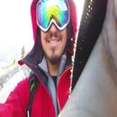
Consider this our summit shot, cuz mountaineering always seems to have a rock n' roll feel to it.
Thumbnails for uploaded photos (click to open slideshow):
I agree 100% with that analysis, Kevin. The views of Gladstone from there are incredible. Pumped for you all! I tipped a Tempter IPA in your direction on Sunday night .
...of seeing those mtns covered in snow! Solid work on a difficult winter climb! Pics 2 & 3 show some of the southeast face of South Wilson... do you have any other pics that show that aspect? Much appreciated if you are willing to share!
I think I felt the winds exfoliating my face again as I sit here in the cozy confines of my corporate cubical. Excellent write–up that perfectly captures the changing feelings of the day.
Yep I thought that coat might have been a goner, but just when I thought it might sail away over the ridge between Gladstone and Mt. Wilson the mountain gods decided to nicely deposit in a safe place for me to retrieve it.
Great work on this excellent summit. Loved the write up and narrative for the climb. Looks like a pretty great day out there. Congrats to all for gettin after it!
well worth the 2 year TR hiatus Pap! 1/31/2015 6:14am
Kevin, I liked this TR so much I went back in time and reread a few of your old ones. Great stuff. Looks like y’all did this one right and then some. Hope the post climb festivities up in Yankee Boy made that Maharaja taste that much better!
Your lead photograph is truly amazing. Suitable for framing, for sure. What a fantastic TR. Didn’t know about this route, until now. The wheels are turning. Nice work on it.
Good to see you back writing a TR, Papi! I was cracking up reading this, especially the roller ball reference. It was sweet that everything fell into place for this trip other than the wind part. I bet there are some winters when this route is never "in" as the Wilsons usually get a healthy dose of snow with few dry windows. The avy chutes in that drainage are about as intimidating and unavoidable as Montezuma Basin. Great job, Papi!
right now. Where are you? Can’t we just be friends? What happened to your mind on Mt. Wilson? Is this payback because I did not poach your trench? Congrats on the summit!
Caution: The information contained in this report may not be accurate and should not be the only resource used in preparation for your climb. Failure to have the necessary experience, physical conditioning, supplies or equipment can result in injury or death. 14ers.com and the author(s) of this report provide no warranties, either express or implied, that the information provided is accurate or reliable. By using the information provided, you agree to indemnify and hold harmless 14ers.com and the report author(s) with respect to any claims and demands against them, including any attorney fees and expenses. Please read the 14ers.com Safety and Disclaimer pages for more information.
Please respect private property: 14ers.com supports the rights of private landowners to determine how and by whom their land will be used. In Colorado, it is your responsibility to determine if land is private and to obtain the appropriate permission before entering the property.


")
 South Wilson, Mount Wilson, and Gladstone Peak")
 Enter the Dragon")
 One foot in the grave sick.")
 Rollerball action...")
 Shhhhhh...")
 Upper Slate Creek")
 Council of War")
 Getting closer.")
 The NE gully.")
 Spindrift and The Vortex. We swapped shoes for spikes on the right edge of the rocks several hundred yards ahead.")
 Shawn had to retrieve his jacket here.")
 Eric and the booter. Summit in the center.")
 Upward on firm snow.")
 Options.")
 Mountaineering.")
 Steeps.")
 Here we go...")
 Christmas card-worthy. Nothing like scaring the heck out of relatives during the holidays.")
 Joe tops out to mesmerizing views.")
 I knew Kevin wanted this one badly. Congrats, my friend.")
 Looking down our ascent route.")
 Wilson Peak and Gladstone")
 Heading home.")
 Terrain from the summit to the col. This area doesn't see a lot of traffic. Achtung baby or hasta la vista baby...")
 Sarah Bear has 99 problems but the El Diente snowflake ain't one...")
 Farewell Slate Creek...")
 Hello Forest of Suckass...")
 So this is what this area looks like during daylight hours...")
 Consider this our summit shot, cuz mountaineering always seems to have a rock n' roll feel to it.")