Download Agreement, Release, and Acknowledgement of Risk:
You (the person requesting this file download) fully understand mountain climbing ("Activity") involves risks and dangers of serious bodily injury, including permanent disability, paralysis, and death ("Risks") and you fully accept and assume all such risks and all responsibility for losses, costs, and damages you incur as a result of your participation in this Activity.
You acknowledge that information in the file you have chosen to download may not be accurate and may contain errors. You agree to assume all risks when using this information and agree to release and discharge 14ers.com, 14ers Inc. and the author(s) of such information (collectively, the "Released Parties").
You hereby discharge the Released Parties from all damages, actions, claims and liabilities of any nature, specifically including, but not limited to, damages, actions, claims and liabilities arising from or related to the negligence of the Released Parties. You further agree to indemnify, hold harmless and defend 14ers.com, 14ers Inc. and each of the other Released Parties from and against any loss, damage, liability and expense, including costs and attorney fees, incurred by 14ers.com, 14ers Inc. or any of the other Released Parties as a result of you using information provided on the 14ers.com or 14ers Inc. websites.
You have read this agreement, fully understand its terms and intend it to be a complete and unconditional release of all liability to the greatest extent allowed by law and agree that if any portion of this agreement is held to be invalid the balance, notwithstanding, shall continue in full force and effect.
By clicking "OK" you agree to these terms. If you DO NOT agree, click "Cancel"...
Here are the accounts of my solo daytrip of Pyramid Peak via the West Couloir/NW ridge and since I can only add a little to the discussion of the route, I will let the work of the much more articulate Floyd do the majority of the talking. Or not, if you are so inclined.
If Impatient, I recommend fast forwarding to 3:57
I must say, there is something about this range that has always captivated my simple sensibilities. Apart from the striking jagged ridgelines with rock better suited for your dining table (to match the cherry cabinets of course) and the sweeping faces caked in snow, the culture of the Roaring Fork valley and their love of the surrounding mountains is unmistakeable. An area truly born from the mountains where a peak is a great deal more than just a checkbox.
I am usually up to invite the select crew of people I have grown to trust and enjoy their company, but for this go-around it would appear I would be going solo and was actually quite excited to hopefully have the valley all to myself.
Discounting the one or 2 30 second hands-on-pole, head-on-hands naps and the fact that my eyes weren't even open half the time, the 6.2 mile, skin up the groomed road from Lazy T was as awesome as one could imagine (crickets chirping). With no views this time, I valiantly searched for a remedy to the monotony and came up with exhale ice on my coat and Zevon's "Roland the Headless Thompson Gunner" as my only sources of respite (music would probably help this....Mock, yeah. Ing, yeah. Bird, yeah. Yeah, yeah...) First Morning Rays on Maroon
A track had been laid down between Maroon and Crater lake (bummer ). I would later find tracks on the ridgeline when I topped the gully and very faint ones higher up on the ridge. Wonder who it could have been? Probably just some badass Aspenite on a milk run (even though it appeared they overnighted).
Looking Back Towards Crater Lake
Bushwacked my way a little bit to the gully (the first obvious big one on a topo) and started up. The snow in the bottom portion felt firm and recent slides had left a hard surface with 4-5" on top. I ditched the splitboard in a safe location in case an avy were to roar down the gully (sans me hopefully) and booted up, eventually switching to crampons.
More Up. Standing on Recent slide.
If you try to sit, I'll tax your seat
Made my way probably half way up the gully before I deemed the snow conditions a little too risky then continued my ascent up crappy scree on the left side.
Another View of the Topout
Standing at 12,680 and the Start of the NW Ridge for Me
Batter Up. Went up First Couloir Hooking Left (Taken on Descent)
View towards the NE Ridge across the Amphitheater Cirque. Wonder if that's the bypass I've heard about??
With a little snow cleaning, the 4th class headwall felt easier this time then in March of last year. Unfortunately, the infamous bowl was a little more loaded than what I would of liked. It was the very first section of the traverse that slid on me last year causing Luke and I to turn around. Armed with some new knowledge (been hangin out with too many damn skiers), I proceeded to hurl rocks at this section in a feeble attempt to make it slide. It did not and the thuds sounded as inviting as a 60 year old ice cream truck driver....so naturally, off I went.
Crux Headwall, Taken on Descent after Rap
No Way Around This Puppy
Boy Have I Got Just the Popsicle for You!
Once that I was over with and I could breathe a little, I was confronted with the following view.
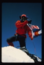
Summit on the Right
A little disheartening if I'm honest but it was actually pretty fun and probably took me a good 30 minutes (little more work involved than it may appear especially with the snow). Tried to stay left as much as possible to avoid snow.
Some Rise, Some Fall, Some Climb, To Get to Terrapin
A View East
Excitable Boy, They All Said
Climb Up was Fun and None too Serious. Descent with Sugar left a lot to be Desired so just decided to Rap
A Look Down at the Sketch Bowl
The Infamous Bowl on the Return. Notice the Old Crown. Yikes
Looking into the Gullet of the Beast
Glissaded some down the West gully and set off a slow moving wet slide from the top that would end up going down a good 500' on the line. So you're welcome for that.
Well You Wore Out Your Welcome With Random Precision
Stats on the Ride:
Leave Car - 2:45am
Maroon Lake - 5:40am
Topout Gully - 10:15am
Summit - 12:30pm
Car - 7:15pm
Total: 16.5 hours
Mileage/Vert: 21 miles, 6k
Gear: Normal junk and a 30m.
Being the good buddy that he is, Monster5 hiked up the road unbeknownst to me and ran into me a mile later. Even though he had single handedly ruined my solo effort, I gotta admit I thoroughly enjoyed the company for the last bit as gliding down that road was getting horrendously old. We then went over to Luke's for some awesome homemade dinner....thanks fellas! I'll make sure to repay you guys with 9.5 tomatoes next time I see you!
Tread Lightly My Friends. Couple Skin Laps Up Buttermilk the Next Day and Got to Enjoy This View!
Thumbnails for uploaded photos (click to open slideshow):
Austin (apsnow, aka one of the damn skiers) nailed it on the head. I didnt just wing this climb. I saw a window based on what weather had been doing and took it. Thankfully it worked out. I’m not even close to a badass in any sense of the word, just a guy willing to explore a little bit of the unknown.
Please dont let my mild mannered writing style come off as carelessness
Anyways, appreciate your comments. She is very much a looker.
Caution: The information contained in this report may not be accurate and should not be the only resource used in preparation for your climb. Failure to have the necessary experience, physical conditioning, supplies or equipment can result in injury or death. 14ers.com and the author(s) of this report provide no warranties, either express or implied, that the information provided is accurate or reliable. By using the information provided, you agree to indemnify and hold harmless 14ers.com and the report author(s) with respect to any claims and demands against them, including any attorney fees and expenses. Please read the 14ers.com Safety and Disclaimer pages for more information.
Please respect private property: 14ers.com supports the rights of private landowners to determine how and by whom their land will be used. In Colorado, it is your responsibility to determine if land is private and to obtain the appropriate permission before entering the property.


")
")
")
")
")
")
")
")
")
")
")
")
")
")
")
")
")
")
")
")
")
")
")
")
")
")
")
")
")
")
")
")