Download Agreement, Release, and Acknowledgement of Risk:
You (the person requesting this file download) fully understand mountain climbing ("Activity") involves risks and dangers of serious bodily injury, including permanent disability, paralysis, and death ("Risks") and you fully accept and assume all such risks and all responsibility for losses, costs, and damages you incur as a result of your participation in this Activity.
You acknowledge that information in the file you have chosen to download may not be accurate and may contain errors. You agree to assume all risks when using this information and agree to release and discharge 14ers.com, 14ers Inc. and the author(s) of such information (collectively, the "Released Parties").
You hereby discharge the Released Parties from all damages, actions, claims and liabilities of any nature, specifically including, but not limited to, damages, actions, claims and liabilities arising from or related to the negligence of the Released Parties. You further agree to indemnify, hold harmless and defend 14ers.com, 14ers Inc. and each of the other Released Parties from and against any loss, damage, liability and expense, including costs and attorney fees, incurred by 14ers.com, 14ers Inc. or any of the other Released Parties as a result of you using information provided on the 14ers.com or 14ers Inc. websites.
You have read this agreement, fully understand its terms and intend it to be a complete and unconditional release of all liability to the greatest extent allowed by law and agree that if any portion of this agreement is held to be invalid the balance, notwithstanding, shall continue in full force and effect.
By clicking "OK" you agree to these terms. If you DO NOT agree, click "Cancel"...
Snowmass via S Ridge from Schofield Park (Crested Butte)
From Crested Butte, I drove up Gothic to Schofield Pass. From the first parking lot in Schofield Park (trailhead for West Maroon Pass), continue about 1.4 mi to a warning sign. From all I had read about the road through the Punch Bowls, I knew I couldn't take my Subi down there. A high clearance 4WD is indeed necessary, but a short wheelbase isn't strictly needed as there are no steep, sharp switchbacks to Lead King Basin trailhead. Descend at your own risk.
Warning at top of the Punch Bowls
From here, it's about 4 miles to the Lead King Basin trailhead through the Devil's Punch Bowls, mostly downhill. Once you cross a bridge (There was also a ROAD CLOSED sign at the same point), you can continue down the road where you'll have to ford the river (had to do it barefoot; too deep to stay dry). To avoid this, you can backtrack a couple hundred feet from the bridge and cross over a footbridge onto a trail in the woods. Unless you know where to look, you'll miss this following the road. It was only when I was hiking back that I discovered the other end, which conveniently begins right before you have to cross. The trail meets back up with the road at the top of the Punch Bowls. Close to the bottom of the Punch Bowls, I passed a blue Jeep getting ready to be towed out. The front of his roof was caved in, but everything seemed to be OK. I was trying to make Geneva Lake before dark (I had left directly from work), so I didn't stop to ask questions. Not sure if he had flipped off the road or if a boulder had come crashing down on him, but he certainly wasn't happy about it. Not a kayaker or river rat otherwise, but the rapids looked pretty nuts.
Right at the top of the bowls
At the bottom of the bowls. Wrecked jeep right of and above center
A great diversion for the trip back included me jumping into the pool from the 15(ish) foot cliff just below the jeep. Great way to end a trip!
About 2.3 mi from the parking lot, you reach the Crystal/Lead King junction. Go left and you reach the Crystal Mill and the town of Marble past that. Stay right and continue on to Lead King Basin. From here, you get the first view of Snowmass and the aptly named S Ridge.
First glimpse of Snowmass
The road will eventually reach an open meadow and you'll want to cross the bridge at this point. The trailhead parking lot is shortly up the hill. If you hit a switchback, you've gone too far. A few navigational snafus cost me over a hour here, and the quickly coming darkness forced me to camp at the trailhead rather than Geneva Lake. Lesson: Get a larger scale map for more details. Also, I found that I had lost my headlamp along the way, meaning I couldn't continue or get a super early start like I wanted. Lesson: Secure your shit
Cross this bridge
Don't miss the trailhead!
Was out of camp by 5:45 (late) the next morning and quickly made my way up to Geneva Lake. Here I ran into a Denver couple (Andrew and Lindsey:marit77) also planning on doing the S Ridge. After my solo Bells experience, I decided a little company would be welcome and they seemed friendly enough (and they were through the whole thing). Stay attentive and stay left after Campsite 5 or you'll miss the hill that takes you up to Little Gem Lake. Once you reach Little Gem, you can hang a hard right and go down to the creek and back up straight to the base of the ridge. From here, take whichever route looks best to gain the ridge. We chose the second gully from the right.
Took the dark gully (center screen) to the ridge
Looking back from the gully entrance
Geneva from the top of the gully
On the ridge, the rock was surprisingly solid. The large granite slabs were a nice change of pace from the fractious mudstone of the Bells. Not much to say here but just keep on trucking. If the ridge gets too difficult, the best course is usually to drop to the left (west) side and find a path. There was one section close to 14,000' (ish) where it looked good to go over a notch to the left (west), but the better course was to climb some solid slab to the right (east). We decided later that that section was probably the crux of the route.
Andrew and Lindsey on the ridge
Soon enough, you'll gain the summit! At this point, we took a quick snack break and took some pictures. A couple cloud to ground lightning strikes accompanied some mean looking clouds to the northwest past Capitol and we were eager to not be the highest objects in the sky. As we descended however, we didn't see any more lightning and we only got a few drops of rain. By the time we got back to Little Gem, it was a bright and sunny day.
From the summit looking down to Snowmass Lake. Pyramid and the Bells in the distance
North Snowmass and Capitol
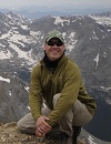
Me on the summit block
Any idea why the actual elevation isn't listed?
Oh, Colorado weather, how you tease
Hiked back to Schofield Park that same day. Andrew was nice enough to drive me just a little ways past the Crystal junction, saving a bit of downhill hiking stress on my knees. We exchanged contact info, hoping to team up for another 14er in the future. Shortly thereafter, I was back at the Punch Bowls. At the end of the long day, their cool pools were a welcome reprieve from the heat.
Ticked another one off the list, made some friends, and on to the next one!
Thumbnails for uploaded photos (click to open slideshow):
From the parking lot at the top of the Punch Bowls to the Lead King TH, it was about 4 miles. It's about another 1.6 miles to Geneva and an additional 1.2 to Little Gem.
Tried the standard route a month ago and failed. Was planning to try the S-ridge the week of 8/3 so your report's timing is perfect. I think this is the best way to go and will never go up the standard route slog again. Great job!
Caution: The information contained in this report may not be accurate and should not be the only resource used in preparation for your climb. Failure to have the necessary experience, physical conditioning, supplies or equipment can result in injury or death. 14ers.com and the author(s) of this report provide no warranties, either express or implied, that the information provided is accurate or reliable. By using the information provided, you agree to indemnify and hold harmless 14ers.com and the report author(s) with respect to any claims and demands against them, including any attorney fees and expenses. Please read the 14ers.com Safety and Disclaimer pages for more information.
Please respect private property: 14ers.com supports the rights of private landowners to determine how and by whom their land will be used. In Colorado, it is your responsibility to determine if land is private and to obtain the appropriate permission before entering the property.


 to the ridge")


 Warning at top of the Punch Bowls")
 Right at the top of the bowls")
 At the bottom of the bowls. Wrecked jeep right of and above center")
 First glimpse of Snowmass")
 Cross this bridge")
 Don't miss the trailhead!")
 Took the dark gully (center screen) to the ridge")
 Looking back from the gully entrance")
 Geneva from the top of the gully")
 Andrew and Lindsey on the ridge")
 From the summit looking down to Snowmass Lake. Pyramid and the Bells in the distance")
 North Snowmass and Capitol")
 Me on the summit block")
 Any idea why the actual elevation isn't listed?")
 Oh, Colorado weather, how you tease")