Download Agreement, Release, and Acknowledgement of Risk:
You (the person requesting this file download) fully understand mountain climbing ("Activity") involves risks and dangers of serious bodily injury, including permanent disability, paralysis, and death ("Risks") and you fully accept and assume all such risks and all responsibility for losses, costs, and damages you incur as a result of your participation in this Activity.
You acknowledge that information in the file you have chosen to download may not be accurate and may contain errors. You agree to assume all risks when using this information and agree to release and discharge 14ers.com, 14ers Inc. and the author(s) of such information (collectively, the "Released Parties").
You hereby discharge the Released Parties from all damages, actions, claims and liabilities of any nature, specifically including, but not limited to, damages, actions, claims and liabilities arising from or related to the negligence of the Released Parties. You further agree to indemnify, hold harmless and defend 14ers.com, 14ers Inc. and each of the other Released Parties from and against any loss, damage, liability and expense, including costs and attorney fees, incurred by 14ers.com, 14ers Inc. or any of the other Released Parties as a result of you using information provided on the 14ers.com or 14ers Inc. websites.
You have read this agreement, fully understand its terms and intend it to be a complete and unconditional release of all liability to the greatest extent allowed by law and agree that if any portion of this agreement is held to be invalid the balance, notwithstanding, shall continue in full force and effect.
By clicking "OK" you agree to these terms. If you DO NOT agree, click "Cancel"...
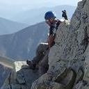
I hiked the Bierstadt/Sawtooth/Evans loop yesterday (Sunday the 13th of July). This was my longest hike, and I really enjoyed the route. Bierstadt was my first 14er actually; I hiked it with my girlfriend about a year ago. This time I wanted to conquer Sawtooth and Evans as well! I had brutal leg and back workouts in the gym this week, so my legs were already beat up to start this journey. But I figured if I can do it on sore legs, I can do longer hikes on fresh legs.
I left my house at about 3am and arrived before the sun at the Guanella Pass TH. There were maybe 6 other cars parked at about 4:40am. I could already see headlamps along the trail, with several along the ridge near the summit; shoutout to those people for an early start! I was on the trail by 4:47am. The sunrise over the ridge Looking West with the sunrise
The initial trail had plenty of puddles and mud patches, but nothing that couldn't be avoided. I later talked to a group of campers that said it rained until about 3:30 or 4am, so that explains the mud. I made quick time up Bierstadt, summitting in 1 hour and 49 minutes after 3.62 miles according to my GPS. My first ascent last year took almost 5 hours with a lunch break, so that was surprising. There were several people on the summit, but it wasn't crowded by any means. Time for Sawtooth! Bierstadt Summit Looking Down the Sawtooth
Last year when I summitted, my girlfriend and I looked at the Sawtooth and agreed that you would have to be insane to try and descend it. It's interesting how my perspective changed after hiking a few more mountains, and testing out Class 3 with the West Ridge of Quandary. The route looked much less intimidating than what I remembered. The descent was slow, but not painful. Most of the drops are hip height or less, so it just makes for slow going. The trail is not particularly well marked on the way down, although I don't think it particularly matters. There were a few portions that I found to be rather steep, and after I descended them, I saw a much easier route down. This wall was one in particular. It is basically a mini-wall that I downclimbed, but I assume the standard trail avoids this dilemma. If you are ever in doubt along this route, take your time to route find and I'm sure you can avoid anything challenging. Looking down at Summit Lake Looking back at a wall obstacle
I made a marmot friend along the descent. There were 2 sections of hard packed snow that you have to traverse. I didn't posthole though and they were not difficult in my regular hiking shoes. Some snow along the Sawtooth My marmot friend Another snow traverse
I encountered a group of hikers near the saddle of the Sawtooth who were coming up from the lakes. I warned them of some rockfall higher up; I heard a rock come loose above me and took cover, but nothing happened. I think someone else was descending above me and set it loose. Just as a general warning, there are portions of loose rock, and the rock seems less stable as you near the saddle. I wore a helmet through this section just in case.
I began to ascend on the other side of the ridge for the latter half of the Sawtooth. This side has considerably more exposure and definitely earns the Class 3 ranking. The trail is well marked with cairns though, and is stable. There are a few badly placed ledges that force you close to the edge and ensure that you stay a little bit puckered. You have a beautiful view of an alpine wall though which makes the ascent very worth it. Almost to the Sawtooth Saddle Looking at the trail on the other side of Sawtooth A wrap around
Once you clear the Sawtooth, the rest of the hike is Class 2 and relatively uneventful. Head for the top of the large valley interspersed with boulders. There are a few cairns along the route, but staying glued to the trail isn't particularly necessary. I summitted Evans in 4 hours and 50 minutes after 6.3 miles according to GPS. The route to Evans was crowded, and the summit was a party. If you've been to the summit of Evans, the highest point is a boulder that is rather precariously perched near the sheer face on the backside of the mountain. A brilliant tourist was climbing this in sandals for a photo op. As if this wasn't bad enough, his young daughter crawled out onto the boulder and he picked her up and put him on his shoulders. I had my phone ready to call 911. On the road to Evans
I began the descent after about 5 hours and 5 minutes. There were plenty of groups coming up the trail which made for a crowded descent. The gulley off of Evans is very easy to locate from the top of the valley. You are basically funneled into it. To be honest, the gulley kind of sucked to descend. The Gulley
I enjoy hiking all types of terrain, and even enjoyed the dreaded Mt. Bross descent. This descent made Mt. Bross feel like a luxury cruise. The route is steep and loose rock/dirt for about 1500' vertical. It is marked with cairns, and the grassy parts have a beaten path. I encountered 3 hikers ascending that left a very obvious bootpack/trail through the willows, a huge thanks to those guys!!! Now for the fun part.
A look at the Sawtooth Nearing the Willows
I knew that the willows section would be muddy and difficult to navigate. The navigation part proved easy, partly due to the path left by those 3 hikers, thanks again guys. I felt a little like a tracker, following their boot prints and broken branches. Then I encountered some mud. I managed to avoid the first mud crossing successfully, but soon realized that this would be futile and time consuming. So I took my low-cut Merrell's for a little mud path; they needed some exfoliation. The trail mixed with a stream in several areas, producing wonderful ankle to mid-shin deep mud. After the first few steps it became rather fun to trudge through!! I navigated to the Bierstadt trail without too many difficulties in route finding. On the trail there were many hikers coming up! There was also a restoration project going on. I want to thank everyone involved in that project for donating your time and labor to help improve and maintain the trail. I thanked the members that I saw, and was pleased to hear many other people doing the same. Without those volunteers, my hike would have been much less enjoyable, so thank you! I am signed up for the Quandary project next weekend, I encourage everyone to check these out because I guarantee hiking would be much less fun without these people's work. There was one last stream crossing that I purposefully plowed through to get rid of some mud I arrived back to my car in 7 hours and 30 minutes after 10.94 miles of hiking according to my Garmin. The drive home was traffic filled, it took almost 3 hours.
Overview: This route is a great intro to Class 3 climbing, with some exposure but nothing unmanageable for a first timer. The route with Evans is a bit long, but definitely worth it with an early start. If you're looking to make the loop more difficult, you might consider the East ridge of Bierstadt, which looks to be pretty exposed Class 3. The mountain was crowded, so an early start is a must.
Thumbnails for uploaded photos (click to open slideshow):
on writing B-S-E report that doesn't suck. So many TRs get posted this time of year that don't add any value for the reader looking to do this route. You did a great job of describing what you experienced and added some great pictures as well. Thanks, I enjoyed reading this trip report.
BTW, if you ever go for this mountain combo in the future try the east ridge, it's awesome fun!
Thanks for the suggestion! I wish I would have done better research on routes beforehand... I just read about the east ridge route literally this morning. It would have been a nice climb, especially with that class 3 Point. I might come back for more practice on Class 3 before some of the more challenging peaks.
Caution: The information contained in this report may not be accurate and should not be the only resource used in preparation for your climb. Failure to have the necessary experience, physical conditioning, supplies or equipment can result in injury or death. 14ers.com and the author(s) of this report provide no warranties, either express or implied, that the information provided is accurate or reliable. By using the information provided, you agree to indemnify and hold harmless 14ers.com and the report author(s) with respect to any claims and demands against them, including any attorney fees and expenses. Please read the 14ers.com Safety and Disclaimer pages for more information.
Please respect private property: 14ers.com supports the rights of private landowners to determine how and by whom their land will be used. In Colorado, it is your responsibility to determine if land is private and to obtain the appropriate permission before entering the property.


 The sunrise over the ridge")
 Looking West with the sunrise")
 Bierstadt Summit")
 Looking down at Summit Lake")
 Some snow along the Sawtooth")
 Looking back at a wall obstacle")
 My marmot friend")
 Another snow traverse")
 Almost to the Sawtooth Saddle")
 Looking at the trail on the other side of Sawtooth")
 Looking Down the Sawtooth")
 On the road to Evans")
 A wrap around")
 The Gulley")
")
 A look at the Sawtooth")
 Nearing the Willows")