Download Agreement, Release, and Acknowledgement of Risk:
You (the person requesting this file download) fully understand mountain climbing ("Activity") involves risks and dangers of serious bodily injury, including permanent disability, paralysis, and death ("Risks") and you fully accept and assume all such risks and all responsibility for losses, costs, and damages you incur as a result of your participation in this Activity.
You acknowledge that information in the file you have chosen to download may not be accurate and may contain errors. You agree to assume all risks when using this information and agree to release and discharge 14ers.com, 14ers Inc. and the author(s) of such information (collectively, the "Released Parties").
You hereby discharge the Released Parties from all damages, actions, claims and liabilities of any nature, specifically including, but not limited to, damages, actions, claims and liabilities arising from or related to the negligence of the Released Parties. You further agree to indemnify, hold harmless and defend 14ers.com, 14ers Inc. and each of the other Released Parties from and against any loss, damage, liability and expense, including costs and attorney fees, incurred by 14ers.com, 14ers Inc. or any of the other Released Parties as a result of you using information provided on the 14ers.com or 14ers Inc. websites.
You have read this agreement, fully understand its terms and intend it to be a complete and unconditional release of all liability to the greatest extent allowed by law and agree that if any portion of this agreement is held to be invalid the balance, notwithstanding, shall continue in full force and effect.
By clicking "OK" you agree to these terms. If you DO NOT agree, click "Cancel"...
My friend Pat and I concocted a brilliant plan to drive to the Lily Lake Trailhead under the cover of darkness on a hollow Monday eve. With an 11:15 p.m. departure time from Golden we were guaranteed a no sleep gnarly ridge traverse under a 60% chance of super cell thunder storms for pretty much all of Tuesday. Some call this stupid. I call this living.
Monday flew by as I tried to get school work done, laundry, feed myself, clean my abode etc. etc.... but mostly I wanted to take a nap from 7-9:45 p.m. because I knew the next 24 hours would be no sleep, all party. I managed to dose off when I was awaken by the most terrifying thunder storm ravaging the streets of Lakewood and its surrounding burbs. Was it a sign? Should I call Pat and cancel? I am sooooo tired. These are the moments one makes a decision. Do I listen to my lazy blerg and get back in my comfy bed or do I go attempt something out of my comfort zone with no guarantee of success. Pat and I both admitted to each other we almost backed out but in the end we left Golden in torrential rain and sped south bound towards the Sangres.
Normally I hate driving period, but driving through the night with no other cars/no traffic was kind of peaceful, the drive down 580 to the Lily Lake TH was anything but. The road is bumpy (and very much high clearance) and 22.4 miles long. It is the most remote TH I have ever been to. We got in our sleeping bags in the back of Pat's truck around 3:30 a.m. with a 5 a.m. wake up call. Just as we began to pass out a partaaayyy truck rolled in busting some techno jams. I expressed my fear of being murdered, Pat said he had a knife, and the party truck left the scene.
Alarms buzzed at 5 a.m. we reset them for 6 a.m. Alarms buzzed at 6 a.m., I complained, we got up and hit the trail by 6:30. We signed the wilderness log in sheet and Pat noticed a man named Martin had checked in heading for Lindsey. Besides a truck that found the best parking spot to be head on in to a tree (belonged to a man and his two daughters), Martin was the only other person around and the only one attempting Lindsey besides us. We were excited to meet him in passing.
I really love the Sangre de Cristo range and I have only seen the Blanca group from a far so I was REALLY excited to be there albeit tired. The Lily Lake trail is straight forward (only minor confusion in a two hour sleep haze) and mellow for the first mile or so. We stayed straight at the junction with Lily Lake. There were several minor creek crossing and one bigger one. I have a bad track record with moving water but I was able to get across with little angst. The trail meanders until suddenly and rather abruptly it starts going up, straight up, loose dirt...ugh my least favorite.
(Taken on the way out) I found the logical way to cross while Pat ham dogged across the widest section with fewer rocks and n
Dying is easy, living is hard.
We grunted and grinded along an alpine stream made of small childrens dreams until we crested out of tree line and got our first real view of the Huerfano Basin. It was stunning. I have explored many a beautiful area but I had to pinch myself this was so breathtaking. These mountains demand respect with jagged terrifying ridge lines. The views of Blanca Peak are heart stopping. The wildflowers are everywhere. Marmots a plenty were joyfully frolicking through green pastures. There was no trash, no foot steps, no people, just a faint trail leading up to a saddle. I felt unbelievably small and so grateful.
Pat identified mountains for me, "over there to the right, we have Gnarly Mountain...." We both looked around and asked each other, "Where's Martin???" Onward we forged up steep loose dirt and some blocky talus to the saddle between Mount Lindsey and the one and only, the infamous Iron Nip. This was our first real view of Lindsey and holy mama cow it was love at first sight. I could see the challenges, struggles, and fun that lay ahead.
Gnarly Mountain, I think it's unranked.
Sneaky selfies.
Grunt work.
This planet is spectacular. Respect it.
Taken from Lindsey/Iron Nipple saddle from top left clockwise: West (Blanca Massif), North (Iron Nipple), South (Lindsey), Ea
I would love to embellish the truth and pretend that I have nerves O' steel, but I don't. Exposure causes my breath to grow heavy, my heart to beat to faster, and I actively have to keep myself in check. I don't just cruise through exposed class 4 with grace and ease, like I was born to mountain goat my way through cliff bands. It is an extra special real challenge for me but I refuse to let it stop me from accomplishing the things I dream about at night. That being said there was not a chance in hell I was going to do the class 2 standard gully nightmare. I would rather grab my fear by the horns and wrestle it all the way to the summit than slip and slide my way up an unstable gully.
From a far the headwall was intimidating. I did not read any trip reports or do too much research on this ridge. Just enough so I knew it was in my ability level but we would be forced to find our own way. We stayed ridge proper and the crux for myself was several moves approaching the headwall and then dropping down to the base of the headwall (difficult 4?, tons of exposure). On the headwall itself we climbed straight up a crack, the last move was slightly overhung. On the down climb off the ridge we located an easier class 3 escape so we did not have to repeat that sequence. Some work must be done to keep this ridge a class 3 or maybe Pat and I were too busy looking for Martin.
Here's us ridging it.........
Initially we were on the trail to the gully of doom but immediately realized and scrambled our way to ridge proper.
Ridge proper, the way things should be.
And a random Pano.... We got some Little Bear, Blanca, and Ellingwood.
To the headwall we go...
Near the headwall ridge proper becomes a daunting task (the crux for me). This is avoided far below on the North side of the
Following creepy proper moves some creepy traverse moves were required as we moved towards a hopeful crack.
A lot less exposure and a little bit easier in this crack.
Almost to the overhung move. A good shot of ridge proper behind me.
Last couple of moves.
Pat told me not to look down.
Little over hang and we are out!
The summit was fun and we were sure we'd see Martin but he still remained elusive. Pat determined he was wearing a rock colored suit. Pat also found an Ipoo'd (a tool (shovel) to bury your poop) a few feet from the wind shelter...any takers? He packed it out.
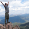
Here we have a summit shot.
In the presence of giants. (Summit pano)
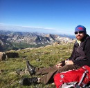
Food inspector.
These beauts... Little Bear, Blanca, Ellingwood, California
The down climb required complete vigilance and was potentially more difficult than the climb itself but we moved quickly and were back at the saddle by 10:15 a.m. I insisted we go for the Iron Nipple (I have a full on obsession with 13ers). It was funnnnnnnnnn......some light, minor, and easy class 2/3 scrambling and a mini knife edge to get to the summit. The route is obvious. If you are doing Lindsey the nip is a must. The summit register was one I could open, win!
Me vs. Pat, knife edge.
My favorite pano of all time in all the lands (from the summit of Iron Nipple)
Iron Nipple summit photos.
Mount Lindsey from Iron Nipple
We were ready to head down when Blanca Peak started erupting.
We arrived back at the saddle for the third time at 11 a.m. and started doing something that resembled an exit from Huerfano Basin. We crossed a large snowfield to avoid loose dirt and located a fresh set of male hiking boot tracks, MARTIN!!!!! We were hot on his track and determined to find him before the days end until we stumbled across a baby marmot eating a flower. We talked to it like it was a cute puppy and snapped endless pictures. They have little hands!!! I was pleased to learn Pat shared my love for marmots (cutest animal alive). We chatted about what they were, both acknowledging rodent but beavers? rats? ground hogs? I think we settled on beaver rat. I googled it when I got home and they are actually large squirrels.
Fat baby marmot butts
Precious
Frightening clouds engulfing Lindsey.
Approaching tree line we ran in to the father and his two daughters and had a very entertaining conversation with them. What lovely people. However, I forgot to ask him why he parked his car in a tree. They had a hot lead on Martin's where bouts but it was becoming obvious he was to ninjaesq to be caught by two newbie climbers.
Back at the stream made of childrens dreams we made an unnecessary crossing to investigate an old mine. Turns out we are both big scare-dies. I thought a mutant cave dweller was going to come out and attack us while Pat said he hadn't come this far to have a mine collapse on him. Probably a bit more reasonable.
The alpine stream made of childrens dreams...
I'm in a mine.
When we got back to the trailhead Pat bee lined it to the wilderness check in and saw Martin had safely returned. It was his 53 fourteener and he had taken the NW ridge route up and returned via the north gully. Martin where art thou in your rock colored suit??? We may never know but good job bud, good job.
We were stalked by a cop for 23 miles back to the I 25 junction. In our sleepless paranoid I just climbed two mountains state we were convinced he was setting us up for the perfect takedown even though the worst thing he could do was issue a speeding ticket. When we pulled over to get gas, so did he. Turns out he was just driving to the most happening spot (said gas station) in Walsenburg Colorado to gossip about the previous nights evacuation of a boy scout troop who was camping near an area about to flash flood. Home we went.
That was some of the neatest 24 hours of my life. Thanks for the laughs Pat, twas a blast!
Edit~~~~Breaking News: Following a hot lead on instagram, #mountlindsey Martin was located and we are now following each other. Thanks to technology and social networking the mystery of Martin was solved, he was in the gully while we were navigating the ridge. We can put this case to bed....that's what she said.
Thumbnails for uploaded photos (click to open slideshow):
...here, last name Martins, first name G. Great trip report - seems my fun would have been exponentially increased by meeting up with you guys!! I too ran into the gent from Texas with dogs and daughters - quite interesting. I'll be sure to holler next time should we be on the same peak!
...Trip report. The photos are great! What did you two use to take your photos?
I just read the route description for this hike on here the night before you posted this TR. Definitely moved this hike up my ”to-do” list. Looks like a blast!
... is the only way I could describe the cascading waterfalls through the terraced flowers along the path. Good call on the ridge both ways. My friends & I came down the gully... pratfall to bloodied palm on a stupid dinner plate. Nice TR on a great route!
Actually thinking about doing this hike soon and the pictures inspired me to give it a shot! Nice TR! Keep em' coming.
Caution: The information contained in this report may not be accurate and should not be the only resource used in preparation for your climb. Failure to have the necessary experience, physical conditioning, supplies or equipment can result in injury or death. 14ers.com and the author(s) of this report provide no warranties, either express or implied, that the information provided is accurate or reliable. By using the information provided, you agree to indemnify and hold harmless 14ers.com and the report author(s) with respect to any claims and demands against them, including any attorney fees and expenses. Please read the 14ers.com Safety and Disclaimer pages for more information.
Please respect private property: 14ers.com supports the rights of private landowners to determine how and by whom their land will be used. In Colorado, it is your responsibility to determine if land is private and to obtain the appropriate permission before entering the property.


 I found the logical way to cross while Pat ham dogged across the widest section with fewer rocks and n")


, North (Iron Nipple), South (Lindsey), Ea")


. This is avoided far below on the North side of the")


")


")


 (Taken on the way out) I found the logical way to cross while Pat ham dogged across the widest section with fewer rocks and n")
 Dying is easy, living is hard.")
")
")
")
")
 Gnarly Mountain, I think it's unranked.")
 Sneaky selfies.")
 Grunt work.")
 This planet is spectacular. Respect it.")
 Taken from Lindsey/Iron Nipple saddle from top left clockwise: West (Blanca Massif), North (Iron Nipple), South (Lindsey), Ea")
 Initially we were on the trail to the gully of doom but immediately realized and scrambled our way to ridge proper.")
 Ridge proper, the way things should be.")
 And a random Pano.... We got some Little Bear, Blanca, and Ellingwood.")
 To the headwall we go...")
 Near the headwall ridge proper becomes a daunting task (the crux for me). This is avoided far below on the North side of the")
 Following creepy proper moves some creepy traverse moves were required as we moved towards a hopeful crack.")
 A lot less exposure and a little bit easier in this crack.")
 Almost to the overhung move. A good shot of ridge proper behind me.")
 Last couple of moves.")
 Pat told me not to look down.")
 Little over hang and we are out!")
 Here we have a summit shot.")
")
 In the presence of giants. (Summit pano)")
 Food inspector.")
 These beauts... Little Bear, Blanca, Ellingwood, California")
")
 My favorite pano of all time in all the lands (from the summit of Iron Nipple)")
 Me vs. Pat, knife edge.")
 Iron Nipple summit photos.")
")
 Fat baby marmot butts")
")
 Precious")
 Frightening clouds engulfing Lindsey.")
")
 I'm in a mine.")
 Mount Lindsey from Iron Nipple")
")